

Greg
-
Posts
1,873 -
Joined
-
Last visited
Content Type
Profiles
Blogs
Forums
American Weather
Media Demo
Store
Gallery
Everything posted by Greg
-
First flakes here in Wilmington.
-
Exactly what I was pointing out in another post not to mention the CMC running cold which gives some pause also.
-
True, but we can still cash in when we have the upper 20's and low 30s a t this time of year. The mid 30 would be toward the Boston and SouthShore areas for sure but if the dynamics take over it would start as a mix, then a wet sleety snow for those areas.
-
That is usually good news in a step-down process that we're in now. It's good that both Oct and Nov won't go down in histoy as being both above average leading into the winter season.
-
As Will stated, even a NE Wind with a decent high, doesn't have to be a great high in place, would be fine for even Wilmington. I've seen it myself many times even in December. But an east wind and especially a southeast wind would most definitely be a mid-level and even low-level killer for snow with any weak high or marginal airmass in place.
-
I don't think the coastal devestation reached quite 78 magnitude with 3-4 consecutive high tides but it was close. but Boston reported a peak tide of 9.35 ft (2.85 m), which was 1.05 ft (0.32 m) less than the record set in 1978.
-
The problem for BDR is twofold actually. Number 1, it's in a valley. Many call it a shadow effect of the winds down sloping whether from an overall easterly or westerly direction. Number 2, they use a snow gauge. This has to catch snow that is already hindered by the valley shadow effect and also any wind will cause the snow to bypass the gauge a little regardless of a funnel put on top. With these relatively significant hinderances, one can pretty much see why a conservative snowfall report is somewhat the norm for that particular location.
-
-

What strength will the El Niño peak at in 2023-2024?
Greg replied to George001's topic in Weather Forecasting and Discussion
1.8/1.9 January 2024 Peak of 3-month average. -
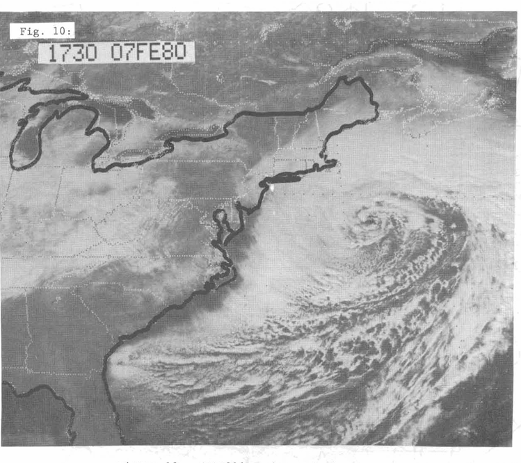
1979-1980 Winter: Predominately a subtropical jet vs the polar jet stream year. As some on the board have illuded to a more active subtropical jet stream potential this coming winter season.
-
Not sure that's actually a state record. Depends upon how far back he compares. 30 years, 60, 90? '78 had that in several places in less that 24 hours and that was a 30 hour storm.. April Fools Days storm of 1997 had a few of those. that was a 24-Hour storm and of course Blizzard of January 2005, 24-Hour storm. So again, not sure what Ryan is looking at.
-
The last hurrah? Putting all the eggs in the Tuesday 3/14 basket
Greg replied to Ginx snewx's topic in New England
Trying to see what I can make of the EC-Fast Euro on the Pivotal now. Just to see what it has. -
The last hurrah? Putting all the eggs in the Tuesday 3/14 basket
Greg replied to Ginx snewx's topic in New England
12Z GFS coming in! -
The last hurrah? Putting all the eggs in the Tuesday 3/14 basket
Greg replied to Ginx snewx's topic in New England
Euro gets Eastern Mass good. Nice hit this run. Nice to have Euro on your side. -
The last hurrah? Putting all the eggs in the Tuesday 3/14 basket
Greg replied to Ginx snewx's topic in New England
Oh well, that's crazy uncle for you -
The last hurrah? Putting all the eggs in the Tuesday 3/14 basket
Greg replied to Ginx snewx's topic in New England
Herpe looks somewhat similar to the evolution the CMC depicts. -
The last hurrah? Putting all the eggs in the Tuesday 3/14 basket
Greg replied to Ginx snewx's topic in New England
CMC and RGEM models are not as great with the thermal profiles as the GFS And NAM. A Usual bias with these models but the precip look good overall. -
The last hurrah? Putting all the eggs in the Tuesday 3/14 basket
Greg replied to Ginx snewx's topic in New England
Exactly! -
The last hurrah? Putting all the eggs in the Tuesday 3/14 basket
Greg replied to Ginx snewx's topic in New England
As I stated earlier, just get that H7 away from that CT coastline and let the Primary Ocean low do its job. -
The last hurrah? Putting all the eggs in the Tuesday 3/14 basket
Greg replied to Ginx snewx's topic in New England
GFS till gives a wallop to Eastern Mass for sure. -
The last hurrah? Putting all the eggs in the Tuesday 3/14 basket
Greg replied to Ginx snewx's topic in New England
Try more like the 1970's. -
The last hurrah? Putting all the eggs in the Tuesday 3/14 basket
Greg replied to Ginx snewx's topic in New England
Same here. -
The last hurrah? Putting all the eggs in the Tuesday 3/14 basket
Greg replied to Ginx snewx's topic in New England
After reading all this stuf from everybody and knowing the 18Z are usually slightly amped, I do hope that H7 based on all the models stays a little more south than scrapping the CT coastline like that. Need that to be less amped so it can allow the primary ocean low to do its job. -
The last hurrah? Putting all the eggs in the Tuesday 3/14 basket
Greg replied to Ginx snewx's topic in New England
The main track of the primary is always most important in winter storms. -
The last hurrah? Putting all the eggs in the Tuesday 3/14 basket
Greg replied to Ginx snewx's topic in New England
This is one of those scenarios that can bust for both Eastern Mass and Western Mass in either direction. Personally, it has a little bit of a flavor of April 6-7, 1982, in the back of my mind. Not to a tee but something along those lines.

