Geoboy645
-
Posts
652 -
Joined
-
Last visited
Content Type
Profiles
Blogs
Forums
American Weather
Media Demo
Store
Gallery
Everything posted by Geoboy645
-
Yeah I would not want to be out in the country after nightfall. I went out of town a little bit a couple hours ago on the backroads and it was already pretty bad. It's going to be basically impossible to go anywhere after nightfall once the wind picks up. I'm guessing our totals are pretty similar to yours, maybe a little less. But it is hard to tell at this point.
-
I mean he finally got banned and within 10 days we get two major snowstorms and are now about to have a big cold blast after we had a record warm December before he got banned. It's only weird if it doesn't work.
-

Winter 2023/24 Short Range Discussion
Geoboy645 replied to Chicago Storm's topic in Lakes/Ohio Valley
Yeah with the water content of the base and the upcoming cold blast. This snowpack isn't leaving anytime soon to say the least. -
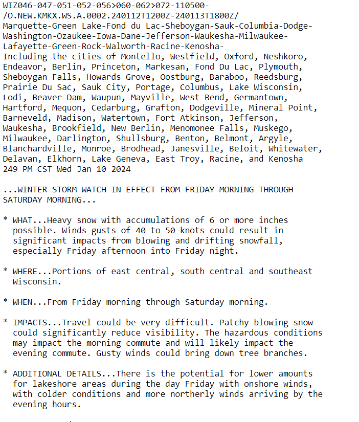
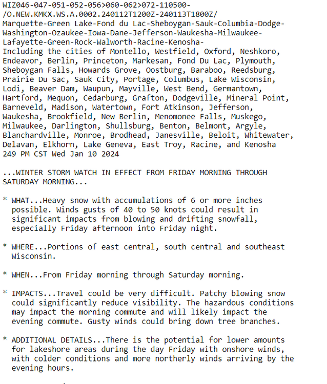
And now MKX has their watches out. And all I am going to say to that is...
-
Yeah that's what I'm looking forward to as well considering I think we have maybe had 6-8hrs of sunshine since December 19th. But yeah this is basically right on schedule for our cold waves so there really won't be any records I don't think. It'd be nice to actually have a cold wave like this on January 15th though, feels like its been a while since we have had that.
-
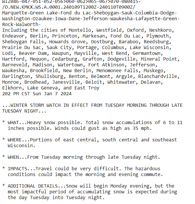
The models have been in pretty good agreement for the last couple days that after the big storm on Friday and Saturday, we could get a legit cold wave for at least the early part of next week. Some runs have had temps as low as the -20s for overnight lows. And while it doesn't look like wind will be quite as big of a factor at this point compared to January 2019, WC's will still probably be within warning criteria as well. Whatever areas max out on snow from this weekend, especially if they maxed out on snow yesterday, could really get down in temperature.
-
Yeah this is looking like its going to be anice hit for us. But I am not looking forward to the drive on 151 during that defo band tomorrow afternoon and tomorrow night. That's not going to be fun.
-
MKX just came out with their Winter Storm Watches and they have decently strong wording all things considered. In fact, with those totals and gusts I wonder if we don't see the B word come out at some point. Some of the open areas are going to be pretty close to that threshold I think on Tuesday. (If you saw this on the other thread, no you didn't)
-
Winter 2023/24 Medium/Long Range Discussion
Geoboy645 replied to Chicago Storm's topic in Lakes/Ohio Valley
Well the next 4-5 days look like 40's and 50's with rain. A nice forecast that will get greenup going with no real frost in the forecast. Seems like we are finally turning the corner into Spring. A pretty typical first week of spring forecast.... wait what do you mean it's the first day of winter?! -
This storm was really the first snowstorm I remember somewhat completely. If I recall it had blizzard conditions for a while at Madisn. This is the one that caused the interstate to close between Madison and Janesville, leading to a bunch of people being stranded for quite a bit. It's the reason why there are crossing gates at select interchanges in Wisconsin on the interstates. This storm, the 6/7/08 tornadoes, and the 08 flooding are the events that really got me into weather. I would love a repeat of this storm, without the people being stranded of course.
-
This incoming rain event over the next couple days looks to be a real drought helper if not a complete buster. Pretty good shot at widespread 1-3" of rain over most of the drought areas. For some spots in S MN and Iowa that have really missed out on the rain this summer. This could legit double their 90-day rain totals at least according to AHPS. Overall a very welcome rain, even if a bit late for crops and the harvest.
-
To expand on this, MKE is located at General Mitchell Airport. General Mitchell is not only well within the UHI, but also dramitically affected by its distance to the lake of only about 2 miles. This is why sometimes MKE really isn't the best gauge for the entire Milwaukee metro or even the city.
-
Hard to believe that that gauge was at major flooding for an extended period of time not more than 5 months ago.
-
-
Interesting note, there is currently a Red Flag warning for the SW and Central areas of Wisconsin. From what I can tell at least since IEM records start in 1986, this is one of if not the first time that these areas have been under a Red Flag warning at this time of year. In fact this is only the 10th time MKX has ever issued a Red Flag warning in general. Not very surprising considering the drought, and with the holiday weekend there are certainly quite a few potential ignition sources. Especially considering that people don't really think of fires all that much in this part of the country, and especially not outside of March/April during our usual fire season.
-
This upcoming heatwave over Labor Day weekend looks to be near record-breaking at least in the northern areas of the subforum. Here at Green Bay, our point forecast for both Sunday and Monday is 95 as of right now. It's a lot harder to get Green Bay up to 95 in general compared to Madison or Milwaukee, but to do it this late in the year is quite extraoridinary. This would be the first time Green Bay has hit 95 or above in September since 1955! And to potentially do it two days in a row is even more spectacular. The only other time Green Bay has exceeded 95 on consecutive days in September was on 09/09-11 1931 where the temp was 95,97,95. If we overperform and reach 96 on either Sunday or Monday it'll be only the third time ever that Green Bay has reached that temp in September behind 09/10/1931 and 09/08/1933. We are also looking at the first 70+ degree lows in September since 2015, which while not nearly as record breaking is still pretty significant.
-
It is amazing that despite having 3-4" of rain in a relatively short amount of time, there's really no runoff issues at all. Just goes to show how dry things truly are rn. In an average summer, this would probably have been at least a minor flood event. This event should at least put the drought off for a week or two, depending on how hot things get next week and for how long.
-
It is currently an ungodly 88/81 rn at Peoria. That is just gross, especially for 10pm at night.
-
https://reservoircontrol.usace.army.mil/nae_ords/cwmsweb/cwms_web.cwmsweb.cwmsindex This gauge was at 500 CFS at 6:30 pm last night. It's now at 48,000 CFS (!). That's almost a 100x increase in flow in 18 hours, and an increase of 30,000 CFS in 2 hours (!).
-
Err these fires are from Alberta and not California. Alberta decidedly did not have an incredibly wet winter. And yes, it is involved with climate change because this ridge pattern that is giving Alberta such bad fire conditions is almost an exact carbon copy of the June 2021 heatwave that oh you know led to the very natural 110 degrees in the Olympic Rainforest. A pattern that almost assuredly couldn't have happened without climate change. And this super unprecedented pattern happened again all of not even 2 years later... Which has led to consistent 80s to 90s and very low humidity and wind which are like the best pattern for fire spread from literally any ignition source.
-
Well this week is the week of the crest. We are now at Mdt or Major forecasted crests at every gauge from St Paul to south of Keokuk IA. And an astounding ~300 miles of forecasted major crests from Winona to Burlington, IA. The crests themselves have gone up slightly, and pretty much every gauge is going to have a top 10 if not 5 or even 3 or 2 crest all time. No crest looks to break records as of rn, at least north of Dubuque. South of Dubuque, is a maybe at some spots including Davenport which is now only 1 ft below the 2019 record crest. Even to the south of Keokuk there are several gauges that are going up into mdt stage, and we have at least forecasted flood stages down to the Illinois confluence. The pattern this week looks to focus the rain south and west of the basin, mainly in the Arkansas and Kansas basins which are quite low because of the drought in the plains. This should help with the crest south of the Missouri, although this is so far out that may very well change. Back up north, we are going to have lock and dam closures at various points along the river during the next week, which will greatly affect shipping along the river. Overall, this is looking to be the worst week of flooding along the Upper Mississippi since 2001 north of Dubuque and 2019 south of Dubuque.
-
As a side note that doesn't really apply to the subforum per se but is still something to note. The first of the meltwater pulses from the megapack in the Sierras seems to be starting this coming weekend. This means that a lot of the rivers in the Central Valley are also about to go back up into flood stage potentially. This will also greatly intensifying the already bad Lake Tulare situation. Looking ahead into next month, we are going to be having two major long-term flooding events occuring at the same time in two different parts of the country. Talk about a far cry from the widespread drought of last Autumn.
-
Well each day the crest forecasts just keep going up and up. Every gauge sans one (Alma, WI) from St Cloud to Burlington, IA is forecasted to crest in either moderate or major flood stage within the next 2 weeks. With every gauge from Dubuque to Burlington cresting in major stage. Which is particularly insane because the crest still isn't even in the forecast period that far south. It's barely in the forecast period for Minneapolis and Hastings. Which btw, those areas are likely to experience a very long time at major flood stage. Hastings for instance has reached major flood stage as of last night, and isn't actually supposed to crest until at least next week Wednesday. This is because as the main Mississippi crest north of Minneapolis pulses through, the Minnesota crest from the Coteau des Prairies is going to be right behind it. That crest hasn't even reached New Ulm, and the main snowpack melted a week ago at this point. Plus now we have the new snow from today's storm which will send the rivers back up in that drainage basin and the Upper Mississippi. The Black has also been pushed back up to moderate stage at Black River Falls and Galesville from the rain and snowmelt the last couple days, which is the reason why the gauges south of La Crosse are just going nuts. Most of them are practically a straight diagonal line up, such as McGregor IA. There, they may actually break the 1965 crest at the pace it is increasing. At least it seems that most streams sans the ones named, and the Wisconsin at Portage, are pretty much done with significant flooding, for now. Emphasis on the for now.
-
And the crests continue to go up and up on the Mississippi. ARX is now expecting at least April 2019 level crests along its entire stretch of the river, with some gauges nearing 2001 levels. For instance, McGregor IA which is just across the river from Prairie Du Chien is expected to reach a top 3 crest on record. Only behind 1965 and 2001. La Crosse is forecasted for a top 5 crest behind those years and 1952 and 1969. Governor Evers has declared a state of emergency already for the flooding. And the rain the next two days, which could be as much as 2 inches in spots including the areas that just got 10"+ of snow two days ago, is going to make things even worse. Especially south of the Black River. It's not just up there though. Dubuque is forecasted at least to 22ft, with that number almost certainly increasing as the crest becomes in view of the forecast period. And even as far as south as Davenport, which is already forecasted at 18.2 ft, which is major flooding. And that is with the crest potentially being 10 days out yet and a continued wet pattern for the forseeable future. 2023 is already shaping up to be a renowned flooding year on the Mississippi, and we've barely started this. P.S: I know that I have been basically the only one posting anything in this thread, but I really don't care. This is too major of a event to be not talked about. If a random snowstorm in January can get incessantly talked about for days and days, this should be too.
-
And now we have forecasted moderate flood stage as far south as Davenport. Out of the 133 gauges that have current forecasts by the NCRFC in their coverage area. 57(!) of them are forecasted to be at moderate or major flood stage within the next week. And that number is probably going to continue going up with the wet pattern forecasted for this week and next weekend. We really went from a dodged bullet to an oh **** moment in like the last 36 hours. This is going to be a very long 2-3 weeks at least for the Mississippi River basin. Oh and btw this is exactly how 93 started, a large snowmelt flood that just kept getting added on because it wouldn't stop raining for three months. Now not saying that that's going to happen here obviously, but the parallels are troubling.