Geoboy645
-
Posts
652 -
Joined
-
Last visited
Content Type
Profiles
Blogs
Forums
American Weather
Media Demo
Store
Gallery
Everything posted by Geoboy645
-
So having driven around a bit this morning. Looks like most streams are at least bankfull if not minor to moderate flooding. The Crawfish is a touch below it's crest in March 2019 on Fall River with likely a few more hours of increases at least. Areas that haven't flooded since that or 2018 are flooded rn. There is so much water just sitting on the fields still. The Rock at Waupun is at MDT stage, and Spring Creek in Lodi is at major stage. And the Wisconsin is going to be at flood stage at Portage, so drainage for the tributaries between the Dells and Lake Wisconsin is going to be slower than usual. If we end up with anything more than an inch on Tuesday, we are in serious trouble.
-
It never ends!
-
And just as I say that MKX issued an areal flood warning for the western half of Columbia county citing standing water in Lodi and washouts and road closures. This is going to be a long few days.
-
That is an incredible amount of rain over two days. I estimate we got about another 2 inches from the round tonight. And we are probably in the neighborhood of 4" over the event here. Combined with an inch from Wednesday and we are at over 5 inches for the week. And probably 10 for the month. Luckily this round moved relatively quickly through. But there is just water everywhere rn. The Crawfish is back up to just below where it was on June 4th, and that's before really any response to tonight's rain. We are probably going to have some flooding issues on every one of the quick response type streams in the area. Unfortunately for Marshall and Waterloo, that especially includes the Maunesha. And unfortunately, we may do this all over again for rain on Tuesday and then next Friday and Saturday. 48 hours is going to be nowhere enough time to dry things out before the next round.
-
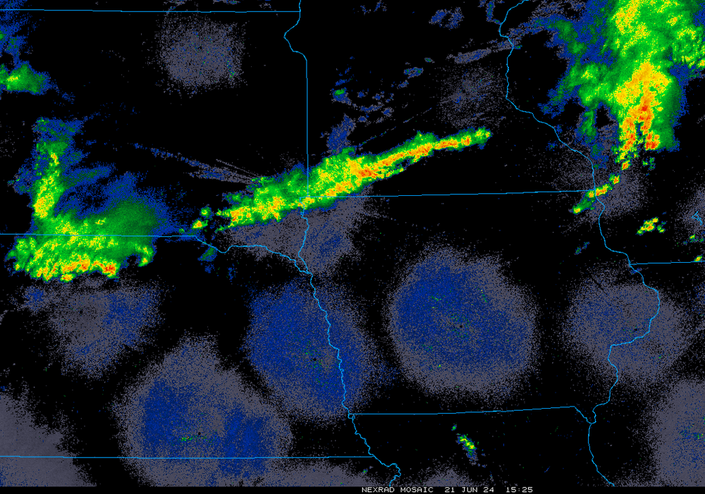
The corridor along and just N of Hwy 78 from Prairie Du Sac to I 39 is getting slammed according to MKX radar. Radar estimated 3 to 5 inches with more coming. And that is some rough terrain to have that much rain on. Edit: Looks like the max is around Parfreys Glen and Prentice Creek. Both of which experienced major flash flood events in 08.
-
Crazy what a few tens of miles difference makes. We have had like .75 here so far. With a 2-3 inch spot N of Sun Prairie that I'm sure is doing wonders to the Maunesha.
-
Not what you want to see at all rn over the flooded areas.
-

2024 Short/Medium Range Severe Weather Discussion
Geoboy645 replied to Chicago Storm's topic in Lakes/Ohio Valley
Well this came out of nowhere.
-
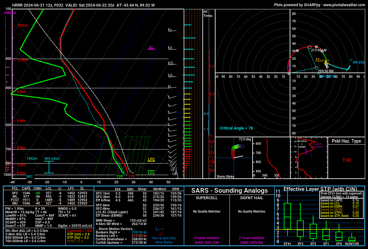
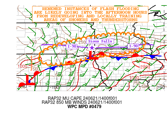
The whole 90 corridor from Chamberlain to Adrian got 3 to 7 inches of rain last night. With another area of 6 plus just S of Sioux Falls. Pretty much every major river from the James to the uppermost Des Moines and pretty much every tributary of the Minnesota is forecasted for moderate to major flooding over the next week. And there's a good chance that some of the same areas could get multiple inches tonight. Even further E, where a corridor from Rochester to Winona is forecasted at 4 to 6 inches in the next 72 hours. Even over here we are forecasted for 2 to 3 inches of rain which is an uh oh amount because we are still so wet locally from the 5/21 to 6/4 stretch.We got 9 inches during that stretch, have had not a lot for 10 days and then just got an inch two days ago with the 2 to 3 forecasted. And tbh, this type of setup has the potential to potentially significantally overperform. This is a very significant flood event underway for the areas to the west, with more to come.
-
As I say that, a FFW now for the West Side of Madison. A training series of popups has dropped like 2" in the last hour, with it still raining. Bad timing with rush hour as well. And today is not that big of a rain setup and we are doing that. Yikes.
-
Well the heavy rain the last couple of days is starting to make it's way into the main stem rivers. The Mississippi at St Paul is now forecasted to get to essentially major stage by the 26th with additional rises thereafter. This is mostly thanks to the Minnesota which is at or forecasted to be at flood stage from New ULM eastward to the Twin Cities. And additional rain is expected, with WPC MDT risks on both tomorrow and Friday, including over the Twin Cities themselves. And the flood threat may extend down here over the weekend, with a chance of storms every day from now until Sunday. And considering we just got a storm that dumped .5"+ of rain in like 20 mins, the atmosphere is certainly primed for heavy rainfall.
-
Some areas just W of the Sawtooths have had 2.5" of rain in the last hour. If those areas drain to the lake, ouch. I would not want to be on some of those streams for the next few hours.
-
Yeah I would not want to be in the eastern BWCAW rn. Areas N of Soudan have 7+" of rain according to KDLH. And there's FFW's all the way to the North Shore now. That is some terrain I would not want to be stuck in a flash flooding event while camping for sure.
-
Yeah the wind has definitely kept things on the not too terrible side. Honestly yeah this heatwave turned to be kind of a nothing burger around here. Warm days and nights, but nothing out of the ordinary, and definitely not what was modeled earlier this weekend. Oh well.
-
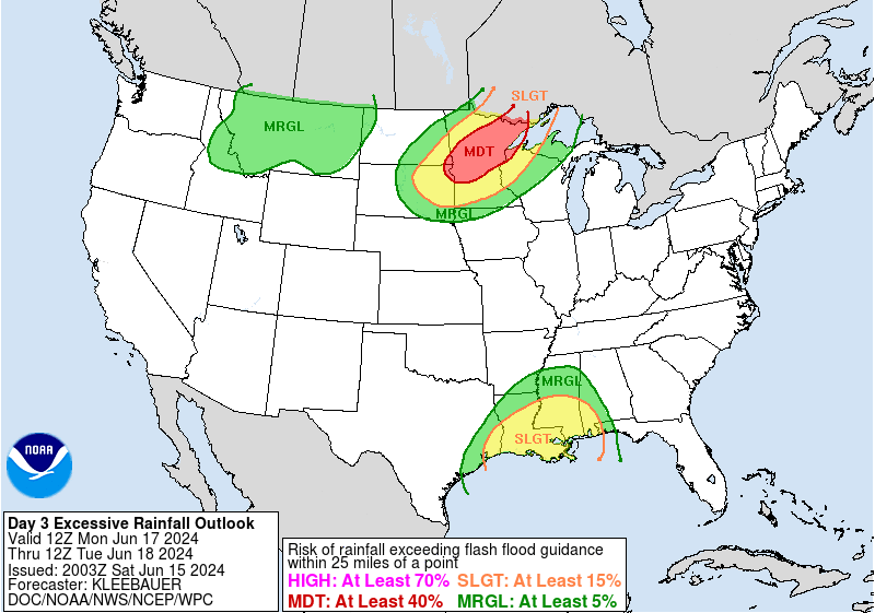
As a corollary to the heatwave, the models have really honed in on a potentially significant flooding event across MN and N WI over the next 7 to 10 days. The WPC has a rare for the region Day 3 MDT for Flash Flooding on Monday, with quite a hefty discussion. They mention the possibility of a flash flooding event not seen in the region in at least the last 10 years within the MDT. Some runs have had as much as 10 inches of rain over the next 10 days in some areas. To make matters even worse, some areas of MN have received as much as 8 to 10 inches in the last month, with several streams at or near flood stage already. Talk about a far cry from the last three summers of flash drought in the region.
-
Summer 2024 Medium/Long Range Discussion
Geoboy645 replied to Chicago Storm's topic in Lakes/Ohio Valley
Yeah that's a big problem considering the potential totals. And this would be efficient summer rainfall so it'll be heavy rainfall rates. Idk how well the Twin Cities can handle a lot of rain on top of it tbh. Minneapolis is pretty flat and the lakes aren't really reservoir like lakes. It's a system that hasn't been stress tested with the amount of growth in that metro over the last 30 years iirc Edit: it appears that the last time the metro had a big flash flooding event at least according to the MNDNR site for flooding was 7/19-22 1987. That period set a diurnal record of 9.15 inches at MSP. There's been 37 years of rapid growth since then, especially in important watersheds such as Minnehaha Creek. And that event was pretty localized and not at the same time as the rest of the state being dumped on with already high rivers. -
Summer 2024 Medium/Long Range Discussion
Geoboy645 replied to Chicago Storm's topic in Lakes/Ohio Valley
Uhhh, thats a lot of rain. That would cause some serious issues on the Minnesota, Upper Mississippi, St Croix, Chippewa, Black, and Wisconsin rivers. Almost 9 inches of rain in the Twin Cities in 10 days would be a really big deal. They have missed a lot of the big summer flooding events within the last 15 years, that's looking like that will change here. -
Well it is looking more and more likely that next week will bring a significant heatwave to the subforum, especially to the S and E parts of the forum. Models have been consistent for a few days on at least 4 or 5 days of mid to upper 90s highs and mid 70s lows starting on Sunday and continuing at least until Friday. Detroit already has a point forecast of 97 on the 19th and 20th which is pretty notable for 5 days out. There's a pretty decent chance that some areas away from the lake in OH and IN tag 100 for the first time since 2012 imo. This ridge is portrayed on some models as going over 600dm which is significant for the region as a whole, let alone being centered over ...Erie PA. Further NW this will probably be more of a typical warm wave with maybe warmer than usual nights. Here in Madison area we are going to be right on the edge of it, as per usual, and it's going to really depend on exactly where it sets up each day if we get the main heat or not. All in all, a potentially significant amount of heat is in store for next week across the Midwest.
-
I think the big thing with this upcoming heat wave isn't so much pure temps, but the dews and the overnight lows. As of rn, the point here has around 90 and 70 degree plus lows every day after Sunday. Downtown Chicagos point is at like 92-95 with mid 70s lows for multiple days in a row. While not super rare, 3 or 4 nights in a row with those lows is still a big deal, especially for people without AC. And the extended looks like more of the same at least S of 80.
-
We ended up getting trained by storms from about 7 to 10:30 last night up here. The closest wunderground station with reliable precipitation data has 2.14" of rain for yesterday. We are now at around 9" of rain since May 21st. The killer is is that even the smaller rain events have overperformed.
-
Y'know what would be nice, if it stopped raining here for a couple days. We have had 6+" of rain since last Monday, with more tomorrow. And its been like an inch or more of rain everytime it rains. Even yesterday's more moderate rain still had a heavy cell that pushed us over an inch here and dumped 2+ between Fall River and Beaver Dam. A brief break on Wednesday/Thursday before even more rain chances over the weekend. All of the rivers are at bankfull, the marshes are getting flooded, and most fields have at least a bit of standing water in them. Easily the most water we have had since 2019. If we get a major rain event (like 4"+ or even 2" if it falls very quickly) we are going to have some major problems across the area. It doesn't even need to be an 07/08/18 style marathon. Even a May 04 event would be very bad rn with how saturated we are.
-
Yeah can we not do a repeat of that? It's going to take at least another week to get fully cleaned up here from Tuesday, and with the Crawfish still quite high we are prone rn to any major rainfall. That's honestly my biggest concern atm out of this stretch, as essentially the corridor from Lodi to Doylestown to Fox Lake to Waupun can't take a whole lot more rain after Monday/Tuesday. As well as points west along the Baraboo, although they are still coming off the drought there so its not as bad. If we get unlucky with either total rain amounts or rainfall rates we could be talking some potential issues along the drainages along that corridor come Monday. We have the potential for the biggest flooding event in the area since the Wild Card flooding in October 2019 in my opinion.
-
Well last night's QLCS was a long night here. We got the initial tor-warned round through at about 8, that line didn't do too much damage. However, we got the straight-line winds from the SW from the 2nd round, and that did some damage around here. There are probably a few dozen fallen or snapped trees around the area from the wind, with some areas losing power as a result. If I had to guess we probably got 70+ winds, if not 80+ in the most exposed areas. Notably with the wind coming out of the SW, areas that would be relatively protected from our typical NWerly squall lines experienced the full brunt. Coupled with weakening from last years drought and EAB, no wonder we lost so many trees. Easily the most wind damage we have had here in almost a decade. The last time being the downburst on 7/13/15. After that round came through, some redevelopment occured and we had about 4-5 mins of quarter-sized hail. And while all of this was going on, we got at least 2" of rain. Combined with the rain from the MCV on Monday, some areas to the north of me have had 4-5" within the last two days. The Crawfish is up to bankfull now for the first time in at least a year if not longer. Been a very busy last two days here.
-
Meanwhile up here in GRB, we actually have had a bit of a precip streak going since Friday. Every day since then has had at least .01 inches of rain. And the forecast for the next week shows a pretty good chance of that streak going all the way to potentially next Sunday if later. If we get to 8 days, so Saturday, it's a top 10 all time streak for days above .01 inches of rain. And 11 is our record, from April 1973. GRB has also mentioned areal flooding concerns as we get into the later part of the week, as even though this hasn't been heavy rain with the highest being .32 on Saturday, the streak of days starts to add up after a while. Especially if we get into some heavier stuff on Thursday.
-
Pretty impressive flip-flop between yesterday, today and tomorrow. Yesterday, 78 and sunny to partly cloudy all day with showers and storms later in the night. Today, midday highs barely breaking 45 and rain pretty constantly all day. And then tomorrow it's supposed to warm back up to 68 and partly cloudy. In fact, the lowest temps of the period were at like 1 today when it was 43 out. Temps have been slowly rising since then and should continue all night long.