cold air aloft
-
Posts
116 -
Joined
-
Last visited
Content Type
Profiles
Blogs
Forums
American Weather
Media Demo
Store
Gallery
Everything posted by cold air aloft
-
2019/2020 Mountains and Foothills Fall/Winter Thread.
cold air aloft replied to Tyler Penland's topic in Southeastern States
I'm at work in Canton and rates have finally increased enough to start sticking. Even the roads are starting to slush a little. -
2019/2020 Mountains and Foothills Fall/Winter Thread.
cold air aloft replied to Tyler Penland's topic in Southeastern States
The micro climates in our area is interesting. Just a mile or two in distance can make a huge difference in precip and temperatures. -
2019/2020 Mountains and Foothills Fall/Winter Thread.
cold air aloft replied to Tyler Penland's topic in Southeastern States
That's interesting. All of the temperature stations I've seen in Maggie are between 28-32. -
2019/2020 Mountains and Foothills Fall/Winter Thread.
cold air aloft replied to Tyler Penland's topic in Southeastern States
They are saying the WWA is sufficient for now. -
2019/2020 Mountains and Foothills Fall/Winter Thread.
cold air aloft replied to Tyler Penland's topic in Southeastern States
Maggie Valley -
2019/2020 Mountains and Foothills Fall/Winter Thread.
cold air aloft replied to Tyler Penland's topic in Southeastern States
GSP just released a lengthy updated discussion which is worth reading. For what it's worth they've increased the forecasted snow amount imby from 2-4 inches to 3-5. Basically, as has been noted, the heaviest precipitation hasn't arrived yet. -
2019/2020 Mountains and Foothills Fall/Winter Thread.
cold air aloft replied to Tyler Penland's topic in Southeastern States
Yes they are, I've been checking in over there as well. Radar returns to our west are amped up as well. -
2019/2020 Mountains and Foothills Fall/Winter Thread.
cold air aloft replied to Tyler Penland's topic in Southeastern States
On my morning walk around Maggie. Light flakes falling with a slight NE wind. I can smell the paper mill a little. You Haywood County folks know that’s a good sign. Good luck y’all! -
One More Shot: Feb 20-21 Event
cold air aloft replied to Tar Heel Snow's topic in Southeastern States
The latter. -
2019/2020 Mountains and Foothills Fall/Winter Thread.
cold air aloft replied to Tyler Penland's topic in Southeastern States
A Murphy to Manteo event would be awesome. The way this Winter has gone for most of us so far, it would be poetic justice. -
2019/2020 Mountains and Foothills Fall/Winter Thread.
cold air aloft replied to Tyler Penland's topic in Southeastern States
At work in downtown Canton and the snow is coming down at a steady clip. -
2019/2020 Mountains and Foothills Fall/Winter Thread.
cold air aloft replied to Tyler Penland's topic in Southeastern States
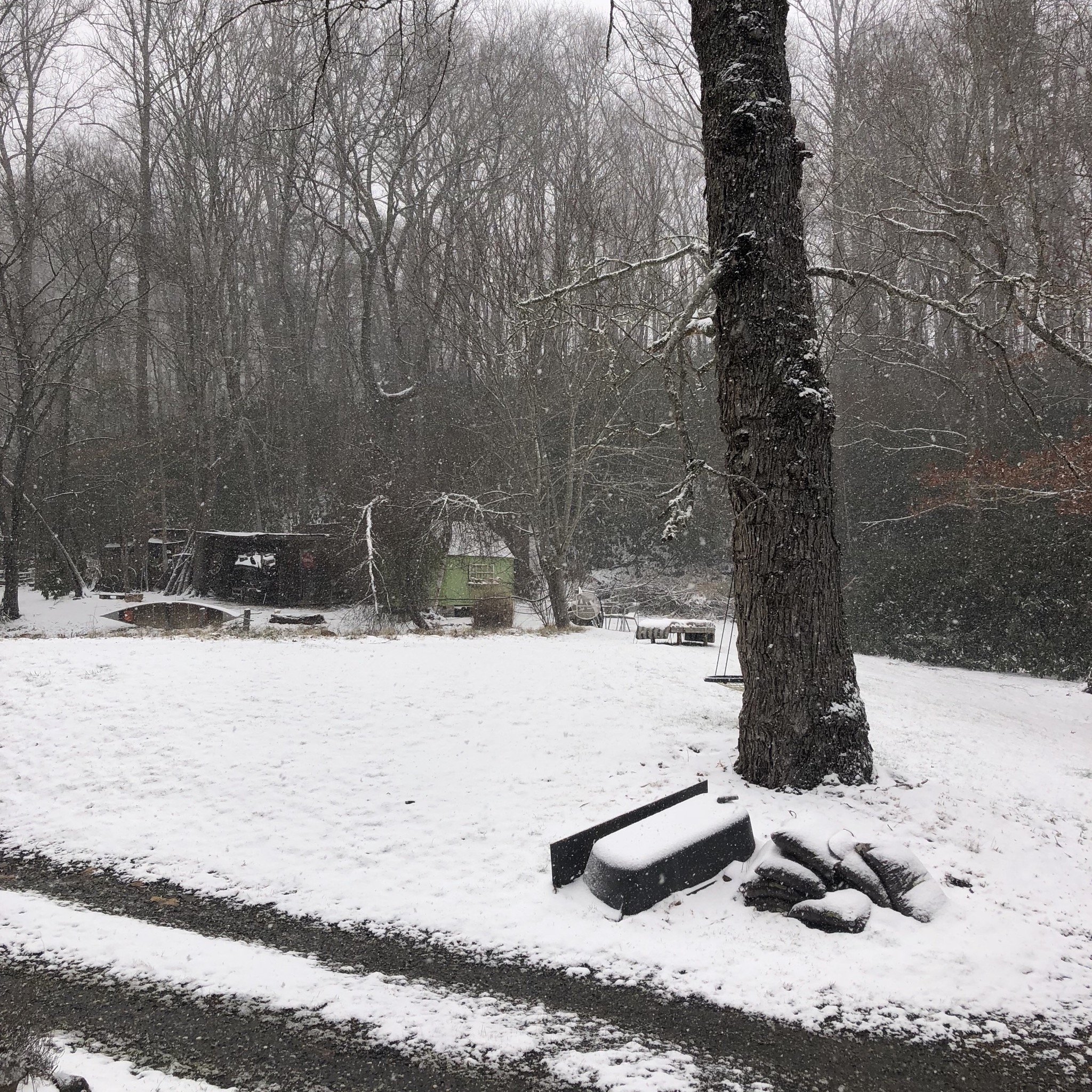
A nice little event in Maggie Valley.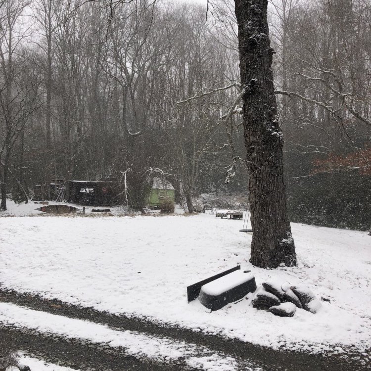
-
2019/2020 Mountains and Foothills Fall/Winter Thread.
cold air aloft replied to Tyler Penland's topic in Southeastern States
Unfortunately radar returns have filled back in to the west. -
2019/2020 Mountains and Foothills Fall/Winter Thread.
cold air aloft replied to Tyler Penland's topic in Southeastern States
Yeah, even though this Winter has been beyond disappointing so far, if you have lived in this area for any length of time you know we still have two more months for something to hit. I actually kind of like the back half of Winter events, freezing rain is less of a worry and with the changing dynamics in the atmosphere as we get closer to Spring, the chances for some thunder snow increases as well. Plus, just the law of averages says we get at least one legitimate event. I'm not going to quit on Winter on January 30. -
2019/2020 Mountains and Foothills Fall/Winter Thread.
cold air aloft replied to Tyler Penland's topic in Southeastern States
Maggie Valley usually doesn't do well with a pure NW flow event, but this event seemed to have more of a due north to south orientation which helped us to cash in. Nice to finally have it look and feel like Winter. -
2019/2020 Mountains and Foothills Fall/Winter Thread.
cold air aloft replied to Tyler Penland's topic in Southeastern States
2 inches in Maggie Valley and still coming down at a decent clip. -
2019/2020 Mountains and Foothills Fall/Winter Thread.
cold air aloft replied to Tyler Penland's topic in Southeastern States
Looking at the current radar returns in central Missouri, the trough is definitely not completely void moisture. From the Kansas City NWS forecast discussion this morning: National Weather Service Kansas City/Pleasant Hill MO 500 AM CST Mon Jan 20 2020 .Discussion... Issued at 336 AM CST MON JAN 20 2020 Interesting weather set up for Monday, which begins with a surface high centered roughly over the eastern Dakotas. With the center of the ridge situated well off to the north, cold air will continue to filter into the region for the next day or so. This would normally keep the weather pretty fair, but currently over central Minnesota a shortwave trough is currently diving southward into Iowa and eventually will move over the forecast area. Now, moisture within the column will be difficult to find, but this trough may provide just enough lift and the air mass may just be cool enough to condense the limited moisture into precipitation in the late morning to late afternoon hours. Maybe we can pick up a little something tonight into tomorrow morning with the frigid air in place. I'm grateful for whatever we can get this Winter. -
2019/2020 Mountains and Foothills Fall/Winter Thread.
cold air aloft replied to Tyler Penland's topic in Southeastern States
At work in Canton. 43 degrees with graupel. I'll take any kind of wintry weather we can get at this point. -
2019/2020 Mountains and Foothills Fall/Winter Thread.
cold air aloft replied to Tyler Penland's topic in Southeastern States
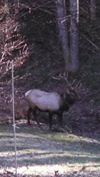
Man, what a beautiful photo! -
2019 Mountains and Foothills Spring/Summer thread
cold air aloft replied to FlatLander48's topic in Southeastern States
Looks like another squall line of thunderstorms is developing in SW part of our region. -
Congratulations, Haywood County is a great place to live. The Smokies and Balsams help to create some fascinating weather situations around here as well. Enjoy!