

tunafish
-
Posts
2,042 -
Joined
-
Last visited
Content Type
Profiles
Blogs
Forums
American Weather
Media Demo
Store
Gallery
Posts posted by tunafish
-
-
anyone tell @PhineasC that was an earthquake that woke him up this AM?
-
5 minutes ago, OceanStWx said:
We're going to need your liquid it looks like, because the PWM precip sensor is hosed. Claiming over 5" for the day.
I did swap guages as soon as it flipped around 145 this AM, so feel confident in my amounts.
-
 1
1
-
-
3 minutes ago, OceanStWx said:
We're going to need your liquid it looks like, because the PWM precip sensor is hosed. Claiming over 5" for the day.
Ha. That was supposed to be 0.62" rain, not 0.61" but I can give you guys a rundown when I call later just to make we have it all straight.
-
Just now, PWMan said:
The funny thing is that it may last longer than last Saturday's fluff bomb.
Finally some sad little flakes mixing in....
certainly will! It's double the QPF this go around. The pack went, per daily 7AM obs, from 11" to 9" to 8" to 7" to 4" to 2" before we started accumulating again.
-
11 minutes ago, PWMan said:
Not a single flake of snow here; sleet of varying intensity all day with surface temps in the low 20s. Maybe an inch of accumulation?
yeah my last measurement brought us up to 1.5" sleet on 0.88" liquid. And that was on top of 0.61" rain.
disgusting.
-
41 minutes ago, dendrite said:
Getting a big push of WAA right now.

Will that push east or is cold air starting to drain down the coastal plain?
-
1 minute ago, Lava Rock said:
I get 3" sleet. Sweet
Sent from my SM-G981U1 using Tapatalk
just think, that's like an extra two weeks that you don't have to deal with your lawn!
-
 1
1
-
-
13 minutes ago, OceanStWx said:
GFS is probably the fastest at 9 PM for getting sub-freezing, and NAMs/HRRR/RAP are all closer to 11 PM/midnight.
Earlier than I thought. Late night on the couch instead of an early morning alarm it is! Thanks.
-
1 minute ago, OceanStWx said:
It's for the combo. Basically frozen precip adding up to 1 inch of QPF.
Still looking at 1-5AM for the flip down here? Gonna set my alarm an hour earlier than the goalposts just to be sure.
-
Might be too early to ask, so I can check again in 24 hours, but what's the rough window of time you expect PWM to flip from liquid to frozen? -
2 minutes ago, Superstorm93 said:
Pick yer poison.
I'll have the cyanide, please.
-
1
-
 2
2
-
-
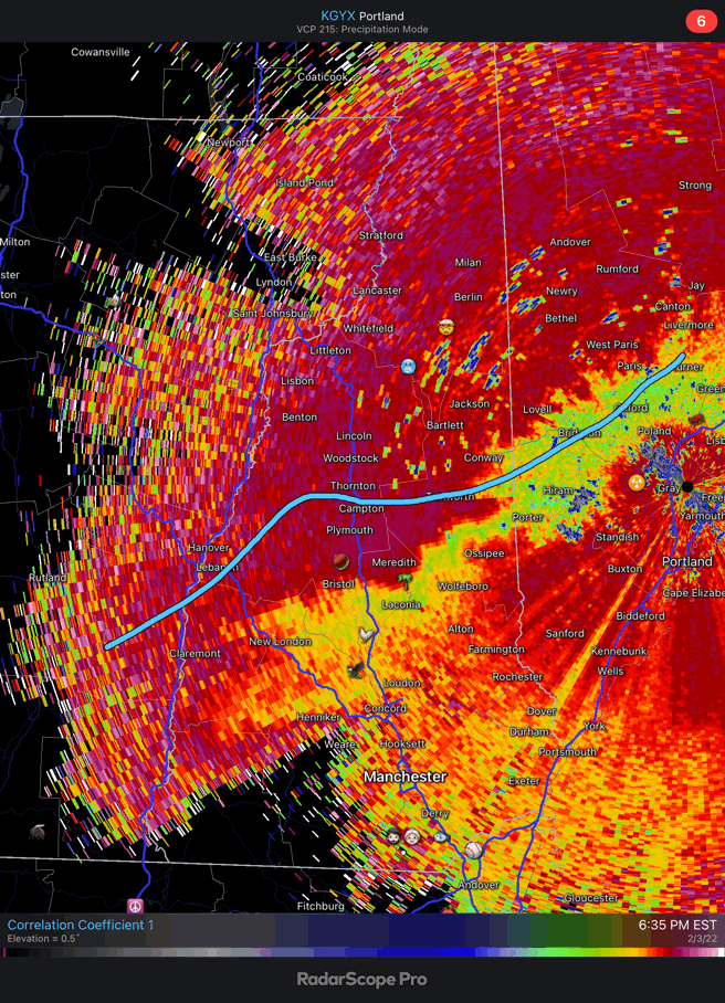
PWM officially hit blizzard status
-
4
-
-
Threw a 3rd snowboard out JIC with the wind. Will average them. Let's goooo
-
 1
1
-
-
1 hour ago, OceanStWx said:
No.
About as classic a going down with the ship forecast as there ever was. PWM ended up with 2 inches after a blizzard warning was hoisted to Sugarloaf.
I think like 5 or 6 of our warnings verified out of 33.
Was that the one where York county still ended up with double digits? That one stung.
Edit: saw your map. Me and @Digityman were toaster bathin' together on that one.
-
Hopkinton, MA - 32"
-
2 minutes ago, Digityman said:
For the first time in a while, I think @tunafish and I are liking being about a mile off the coast....
This helps make up for that all rain event on MLK day, that's for sure.
-
2
-
-
Noob question: What impact does confluence have on the storm?
-
7 minutes ago, DotRat_Wx said:

Shutesbury on the line AGAIN
-
2
-
-
getting some OES here right now. Related to this event?
I'll save you the click.

-
1
-
3
-
-
8 minutes ago, weathafella said:
Dry January. It’s gaining traction
Between Dry January and No Nut November, December must be very, umm, wet.
Onto the GFS...
-
2
-
-
Aren't we outside Reggie range? Or are people looking for changes upstream?
-
1
-
-
2 minutes ago, PhineasC said:
Board is lagging already. 00z may crash it for a bit.
welcome to the north country internet service
")
-
1
-
2
-
-
Last threat we had endless RI geography talk. Now we have CT geography talk. Can it, FFS.
-
6
-
-

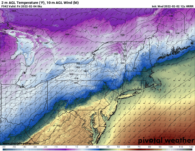
Coastal cyclogenesis and minor to moderate impact Feb 8/ 8.5, primarily SE areas ...for now.
in New England
Posted
Good, euro can keep it's QPF.
Last thing I need is an inch of rain on top of a glacier (4" depth with 1.5" QPF locked up in it).