

chris21
-
Posts
596 -
Joined
-
Last visited
Content Type
Profiles
Blogs
Forums
American Weather
Media Demo
Store
Gallery
Everything posted by chris21
-
There’s no doubt there is more snow in the initial thump in dc at least than 00z... check the soundings..Held steady with qpf in the dc metro.
-
Check out their snowfall accumulation maps.
-
For those keeping track... this a far better run snow wise than 00z for the dc metro at least.
-
Feb Long Range Discussion (Day 3 and beyond) - MERGED
chris21 replied to WinterWxLuvr's topic in Mid Atlantic
Hope they start trending toward the globals but have they ever not been amped and north? It’s anecdotal but I feel like anytime there is a southern slider we can at least count on the srefs to throw us .50 of digital qpf when everything else is dry. -
Feb Long Range Discussion (Day 3 and beyond) - MERGED
chris21 replied to WinterWxLuvr's topic in Mid Atlantic
Suppression fail crew has already taken the 00z shift away from the warm fail crew. -
Feb Long Range Discussion (Day 3 and beyond) - MERGED
chris21 replied to WinterWxLuvr's topic in Mid Atlantic
Was on a terrible streak but nailed the ice storm from impressive range and consistency. -
Feb Long Range Discussion (Day 3 and beyond) - MERGED
chris21 replied to WinterWxLuvr's topic in Mid Atlantic
Strongly disagree, could barely walk outside my house Saturday and sat night. It didn’t accumulate anywhere? NWS reported a .25 inch ice in adams Morgan. -
Feb Long Range Discussion (Day 3 and beyond) - MERGED
chris21 replied to WinterWxLuvr's topic in Mid Atlantic
Ehhh... happens a lot... but we just had a high impact freezing rain event two days ago that was apparently “impossible in dc” even though I’ve seen it many times. -
Feb Long Range Discussion (Day 3 and beyond) - MERGED
chris21 replied to WinterWxLuvr's topic in Mid Atlantic
Yeah, if you look at the strength and location of the high and arctic air nearby and light northeast flow it’s actually a classic situation for a major ice event in dc. Def doesn’t look like an all snow event in dc, but I would certainly not sleep on the sleet/ice potential with this storm given the synoptic setup. -
Feb Long Range Discussion (Day 3 and beyond) - MERGED
chris21 replied to WinterWxLuvr's topic in Mid Atlantic
An east based nao is not the greatest snow look in dec, but with shorter wavelengths it becomes less of an issue in March. West is still ideal always. -
Feb Long Range Discussion (Day 3 and beyond) - MERGED
chris21 replied to WinterWxLuvr's topic in Mid Atlantic
Did pretty well with the ice storm. Showed about .3-.4 qpf consistently and handled the shortwave pretty well I thought. -
Feb Long Range Discussion (Day 3 and beyond) - MERGED
chris21 replied to WinterWxLuvr's topic in Mid Atlantic
Absolutely... heavy zr at 15 would be far more efficient at accretion than heavy zr at 31. -
Some fz drizzle currently in NW.
-
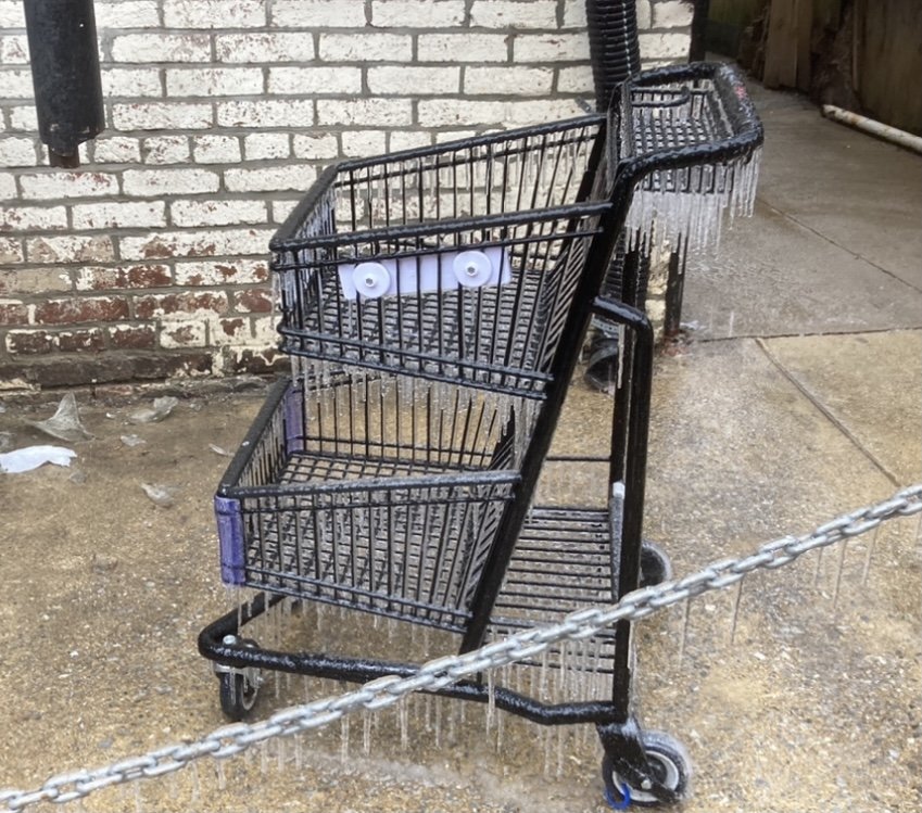
Actually it was far worse than forecast. At least here in NW DC. 27 degrees and falling.
-
Same situation in Mt. Pleasant. Temp has ticked down once again to 28.
-
Mt. Pleasant is def encased in ice!! 29 with sleet/freezing rain continuing. Huge NAM bust lol.
-
I kept pointing that out but everyone told me it was going to be a “non-event”. Looked like a clear high impact event in dc to me at least.
-
Wow, 28 up here in NW. moderate sleet and freezing rain.
-
Precip looks to be redeveloping on nexrad. Looks like a couple more hours of precip prob. Unless temps rise, conditions will continue to deteriorate as the sun begins to fall.
-
With a light ne flow at the surface and really a classic cold air damming look I’ve been wondering the same thing....
-
I think accrual will gradually catch up if the temp does not budge much. Tonight is supposed to be only around 27-28. I just don’t see how all of this doesn’t freeze given past similar situations.
-
Oh man... the sidewalk in front of my house is straight ice in mt. Pleasant. The temp fell to 27 also... don’t think that bodes too well looking at the radar.
-
Sidewalk has caved in nw... sheet of ice. Temp has ticked down 27/23 with freezing rain and an occasional sleet pellet.
-
Not helping much at all in dc now but our temps are a bit lower... 27/28.
-
Already a bust in dc. I thought the NAM was king! lol, this winter....

