
JSharp
-
Posts
126 -
Joined
-
Last visited
About JSharp

-

February 11th,12th and 13th Event. Little Something Something.
JSharp replied to Mikeymac5306's topic in Philadelphia Region
2.3 inches at midnight. This is definitely a heavy wet snow. I'm finally up to double digits for the season. -
1/19/25 Eagles Playoff Winter Storm obs
JSharp replied to Ralph Wiggum's topic in Philadelphia Region
Recorded 3.8 inches here in extreme western Delco. That dry slot prevented me from hitting the NWS 4-6 totals on their map. But it was a decent little storm regarding the snow rates between 5 and 7 PM. -
1/19/25 Eagles Playoff Winter Storm obs
JSharp replied to Ralph Wiggum's topic in Philadelphia Region
After the last couple of winters, it feels like a Herculean effort to get a plowable event. -
1/19/25 Eagles Playoff Winter Storm obs
JSharp replied to Ralph Wiggum's topic in Philadelphia Region
Over a half inch here in Chadds Ford, PA , 20miles west of Philly Int. -
Hello neighbor! It sure came down quick between 1 am and 4 am! Over 3 inches now.
-
3.3 inches herein Chadds Ford Township, PA in far western Delaware County.
-
5 inches already between Qtown and Allentown?....Holy crap!
-
I'm worried about getting dry slotted here in the Delaware/Chester County area.
-
Bravo to NWS Mount Holly! They stuck their nose out when others we mocking their storm totals map and their WSWs. Here in Chadds Ford Township, PA, I ended up with 5.3 inches, which was the biggest storm in two years..... since the 5 incher in late Jan 2022.
-
My cousin was having a baby shower in Shillington that day, which I was planning to attend. Shillington only saw around 2 inches but down my way in Chadds Ford, we saw 7 inches. Roads were all shutdown from accidents and I couldn't go up there because there were near whiteout conditions .
-
Nope. This one was in February, when the Eagles usually don't play. The storm you are thinking about was the December 2013 event, which dropped 8 inches in South Philly. That was during the Eagles game. That came from an overrunning setup, vastly different from a Norlun trough setup.
-
Attached is a great read of the Feb 3-4, 2009 event, which might be very similar to this one. https://www.weather.gov/phi/02032009wss
-
I remember a Norlun trough in February of 2009 which setup over Philadelphia and Gloucester/Camden Counties. This sucker dropped up to 10 inches in the City of Philadelphia and up to a foot in Gloucester county. South of West Chester, where I live, only saw 4 inches. I think parts of Lancaster County (Manheim Twp.) got 12 inches in another very narrow band (10 miles wide).
-
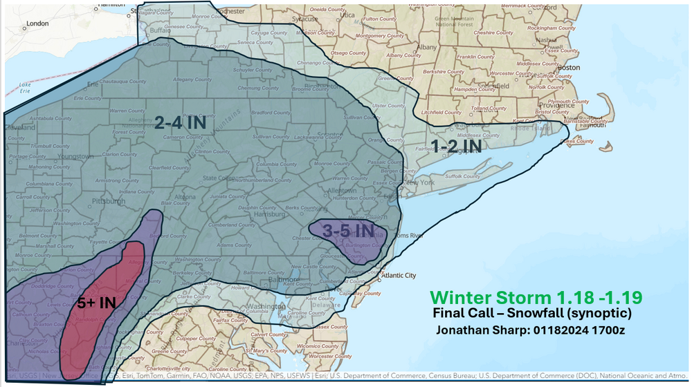
This is the my Final Call snow map that I made around noon today.
-
Finally a storm that didn't bust for the Philly Metro.


