Cobalt
-
Posts
4,908 -
Joined
-
Last visited
Content Type
Profiles
Blogs
Forums
American Weather
Media Demo
Store
Gallery
Everything posted by Cobalt
-
Interesting that the EPS and GEFS now have the PNA nearing neutral around the 13th. Perhaps that could be an early storm signal with some brief west coast ridging? Alongside -EPO, and AO/NAO relaxing from their -3SD minimums. Probably too early into the pattern's progression, but worth noting.
-
-NAO signal on the EPS continues to get more impressive, a 3.4 sigma block appearing as a D12 mean is something. The days leading up to this regime change don't seem particularly toasty either. Some strong + and - temp variation, but the EPS has the first 7 days of December nearing average.
-
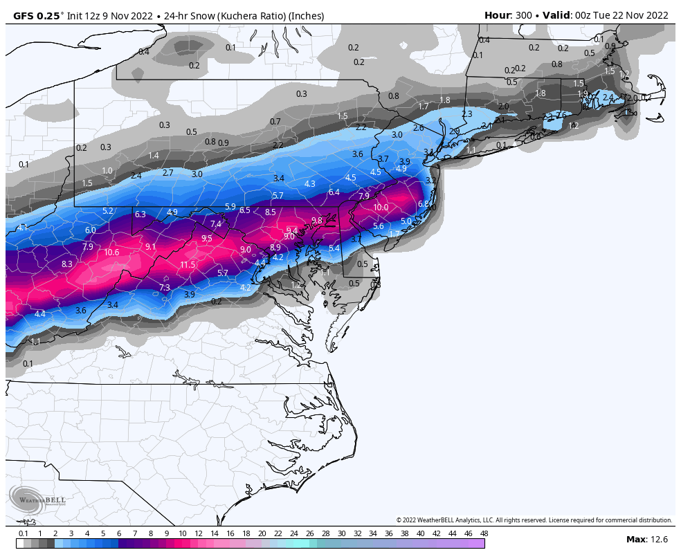
Just your casual 6-12" November snowstorm followed by single digits and sub-zero temperatures.

-
That look on the EPS reminds me a lot of November 2017. Not identical, but overtop there are definitely similarities to the start of the month in both figures.
-
-
Chilly day on tap for Monday

-
Looks like they're back
-
was debating on posting that there, awfully dystopian.
-
bring your pets if you feel teh need
-
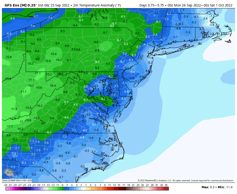
Looks to be relatively chilly closing out September. A rarity given current climo.
-
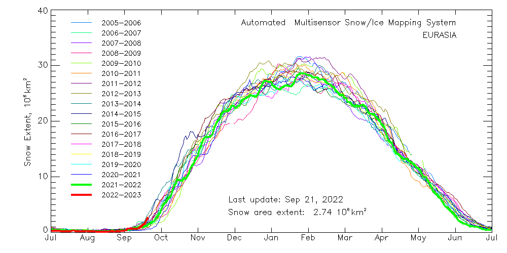
Eurasian snow extent is off to a pretty decent start. Compensating for North America's sluggish (lowest in the dataset to date) snow extent atm.
-
yeesh
-
That 0.6" is 19/20, right? That was a neutral iirc, but it was preceded by a weak Nino in 18/19, so not sure it fits the qualifications you mentioned. Regardless, even with that out of the dataset it's easy to tell where the floor and ceilings are given current climo.
-
I think 22-23 has potential to be one of the winters of all time. Maybe not the biggest, not the smallest, but definitely one of them.
-
33 degrees with moderate snow at 12:30pm on April 18th, kinda nuts.
-
Big snowflakes in Harrisonburg right now, mulch and grass are beginning to get a coating.
-
C+. 13.7" in January is the 3rd most in my 12 year dataset. February was awful, but the March storm helped cap off the winter pretty well.
-

3/12 Event: Winters Last Hurrah at Least East of Mountains
Cobalt replied to Weather Will's topic in Mid Atlantic
Might just be that he’s on chrome, I use the chrome app and it’s not working for me. Moderate snow in McLean, non paved surfaces covered -
Reminds me of that one March event we had in 2015 (March 20th?). Similar timing with it being early morning, and only the elevated and favored areas really got much, which I believe was a slushy 1-4", while UHI hell had nothing but snowTV.
-
There's a bit of a difference in timing between models. GFS is 9-12z Sunday, meanwhile Euro is 0-6z Monday. Probably just noise at this point, but I'd imagine we would want an earlier onset
-
UKIE likes the weekend event
-
Mhm, better cold press and a stronger HP overtop compared to previous ensemble runs.
-
Mid-Atlantic forum winter 2021/22 snow totals thread
Cobalt replied to North Balti Zen's topic in Mid Atlantic
1/3 - 6.5". Fast moving snow bomb. 5" in 4 hours, areas to SE eclipsed double digits. 1/7 - 3.8". Speedy redeveloper w/ a miracle snowband, 1.6" in just one hour. 1/16 - 2.6". Frigid powder turns to sleet/rain with wicked winds. 1/29 - 0.8"* 2/13 - 0.6"* Season Total: 14.3" * = Based on spotter reports Interestingly enough, this is the snowiest La Nina winter for my location (all above measurements are from McLean, Virginia), since at least before the 2010/11 winter. Probably the snowiest Nina since at least 1999/00, which is pretty impressive. Still holding out for a minor event to send us over 15".