

Cobalt
-
Posts
5,222 -
Joined
-
Last visited
Content Type
Profiles
Blogs
Forums
American Weather
Media Demo
Store
Gallery
Everything posted by Cobalt
-

Feb Long Range Discussion (Day 3 and beyond) - MERGED
Cobalt replied to WinterWxLuvr's topic in Mid Atlantic
Improved cluster! Seems like the GEFS is in the ICON/Euro/EPS camp. Canadian politely declined joining for the 0z suite, not without apologizing of course.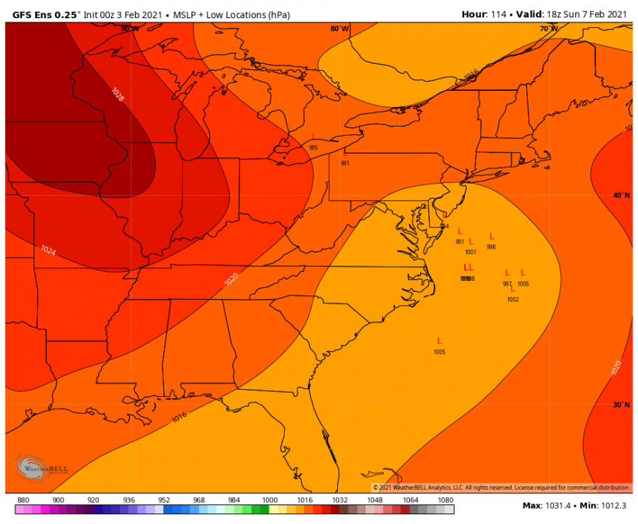
-
Feb Long Range Discussion (Day 3 and beyond) - MERGED
Cobalt replied to WinterWxLuvr's topic in Mid Atlantic
GEFS looks quite improved for the weekend threat. Almost in line with the EPS in both precip and snow mean. Waiting for additional panels to come out such as lp locations. -
Feb Long Range Discussion (Day 3 and beyond) - MERGED
Cobalt replied to WinterWxLuvr's topic in Mid Atlantic
To hit our region? Maybe Feb 12-14 2014?? At least I think but it couldve been hybrid. -
Feb Long Range Discussion (Day 3 and beyond) - MERGED
Cobalt replied to WinterWxLuvr's topic in Mid Atlantic
That's what I was thinking. Certainly not frigid for us but there's still cold air to tap, basically right nearby. Of course we'd be playing with fire, but it could boast well. -
Jan 31st - 33rd Storm Obs and Disco like it's 1979
Cobalt replied to Bob Chill's topic in Mid Atlantic
1.5" on the board as of 10:15am to put the storm total at 5.1" here in McLean!! Despite the big dog potential on this storm, for a Miller B (hybrid?) it's been pretty exceptional. Not often can you have snow falling for 3 days constantly re-whitening surfaces off and on like this. Still light snow now so hopefully that total can be added on to a bit, but this 2nd half of the storm has certainly exceeded my expectations -
Uhh yeah, mhm. Basically my first 2,000 posts were all me being a 14 year old weather weenie. On this board I made the worst impression I could've conceivably made. I can see why you guys are harsh to newbies who don't know their place, because even if that caused sidetracks from the main issue at hand (I recall having a multi-post sequence in regards to speculation about me being possibly being conceived in the Feb 2003 blizzard which was... un unpleasant thread to say the least), in the end the harshness helped big time. It denounced the weenie-posting side of me but at the same time encouraged me to learn more from the more respected members of the forum. I'm still not an exceptional poster in the slightest, but those nudges in the right direction certainly strayed me off of a path of being 5-posted, and for that I'm grateful. Everyone's gotta start somewhere in this field, and while most people start off rocky, this place is an exceptional way for people to get their footing in the world of meteorology. It's not the one month members weenie posting that concerns me, it's the people who know exactly what they're posting and do it anyways with no regard to the discussion that they're disrupting.
-
Jan 31st - 33rd Storm Obs and Disco like it's 1979
Cobalt replied to Bob Chill's topic in Mid Atlantic
.5" since midnight. 4.1" on the storm, and despite the WAA fail it's still been a pretty great event considering everything. Hoping to get close to verifying the WSW with snow showers through today. -
Feb Long Range Discussion (Day 3 and beyond) - MERGED
Cobalt replied to WinterWxLuvr's topic in Mid Atlantic
12z had that feature too. Not really sure how that doesn't impede the storm but it's still an interesting solution, but yeah how can a 999 lp near Ohio and a 985lp off the coast of NJ both strengthen like that at the same time? :p -
Feb Long Range Discussion (Day 3 and beyond) - MERGED
Cobalt replied to WinterWxLuvr's topic in Mid Atlantic
Euro's Sunday storm doesn't have the trough digging as much as it did for the massive 12z storm, but still gets the job done. 0z GEFS also backed off of the Euro idea with a flatter and more broad trough (product of less ridging out west to my novice eyes?), but still has the window there. Will be interesting if the EPS bleeds to the GEFS solution, but obviously we're still way at range. Euro's solution is still pretty fun to see still lol -
Jan 31st - 33rd Storm Obs and Disco like it's 1979
Cobalt replied to Bob Chill's topic in Mid Atlantic
Went on a Jebwalk and it surprisingly snowed decently the entire time. Came back to see how that band has basically pivoted over us, super nice. -
Woww, those death bands must be crazy up there!
-
Jan 31st - 33rd Storm Obs and Disco like it's 1979
Cobalt replied to Bob Chill's topic in Mid Atlantic
3.6" total on the event. 2.5" with the initial WAA thump, as well as 1.1" so far today (not counting the massive sheet of ice I had to deal with when clearing my board, when did that happen?? Maybe like a quarter of an inch of solid ice). Pristine winter day out there. Hoping the ice preserves the snowpack until our polar blast next week. Also got to enjoy the snow with my German Shepherd. He honestly might be a bigger snow weenie than I am lol. Glad peeps in N Maryland cashed out big from this, you guys deserved it!! Hoping this is just the start of a memorable February -
Fights over snow are... interesting to say the least. It's as if we're the last of our civilization fighting over a bastion of water, only in this case it's frozen water, and even that frozen water is pixelated, and even then the pixelated water is on a screen sent from a bunch of supercomputers a continent away.
-
I was actually thinking.. although that was a reverse bust, it feels like most of our good patterns this past decade have been ushered in by busted forecasts. Feb 2014 started off with the Jan 21 storm being forecast as a 5-8" storm, but fell short near and around DC. Feb 2015 started off with the Feb 14 storm where most areas were forecast to get 5-10" but a nasty dry slot cut things off.. heck even March 2013, managing to get a near WSW level event in late march is impressive, and of course that month started with Snowquester. Perhaps we need to understand failure to get a taste of success around these parts.
-
It's borderline comical at this point. The Euro sees our Miller B woes and throws us a bone with a Miller A all the way out at day 7.. might follow the Bob Chill way and just unsubscribe from WxBell and focus on stuff within 3 days lol. But hey, regardless of what falls today through Tuesday, we had a tracking period where a storm threat never lost its grip from 7 days out and.. we got the storm! Just needed a few things to go right to get more, but with the grass covered it's still looking pristine out there.
-
Jan 31st - 33rd Storm Obs and Disco like it's 1979
Cobalt replied to Bob Chill's topic in Mid Atlantic
1.9” as of 10:15am here in McLean. Rates a bit higher than they were this past hour, but still somewhat light snow. Can’t complain though, getting most of a January’s worth of snow in one storm certainly isn’t a gut punch, even if it isn’t the 1’+ costal we were all hoping for. Meanwhile Gus absolutely loves it, so if he’s happy I’m happy. Kicking around the ball for him while powder accumulated makes this all worthwhile. . -
Jan 31st - 33rd Storm Obs and Disco like it's 1979
Cobalt replied to Bob Chill's topic in Mid Atlantic
NWS updated totals and extended the 6-8" line a bit south of DC, and lowered 8-12" totals to the immediate north. Still a pretty decent event Remember that regardless of what falls, anything above 4" for the metro area is still one of the biggest La Nina snowfalls so far this century! Enjoy it everyone!! Certainly doesn't look to be our last threat of the year either. Anyways, goodnight, hoping to wake up to the WAA snows arriving at our doorstep -
I remember him mentioning that the full moon and strong costal combo would boast well for a major DC/Baltimore snowstorm.. For 1/4/18. I jumped off the team Roger ship then, but his forecast verifying would surely bring me back.
-
Feb Long Range Discussion (Day 3 and beyond) - MERGED
Cobalt replied to WinterWxLuvr's topic in Mid Atlantic
One of the mets who doesn't post here all that often chimed in back in mid January and mentioned how most of the Canadian airspace was dominated by low pressure systems, which was in part causing a majority of Jan to perform a rug pull. Just checked the EPS and it's an incredible reversal, HP train all the way from the source. Seems like the GEFS isn't as cold and dry as it was showing 1-2 days ago either, looks pretty EPS-like. Fun times ahead!! Also the EPS brings back our constant barrage of 50/50 lows and spins them around from day 8 onwards -
No please, it's already shifted Northeast from 12z just by the slightest thought of you returning to NoVA. Think of the weenies dude, gotta take one for the team.
-
Jan 31st - 33rd Storm Obs and Disco like it's 1979
Cobalt replied to Bob Chill's topic in Mid Atlantic
Shut up Chuck -
Feb Long Range Discussion (Day 3 and beyond) - MERGED
Cobalt replied to WinterWxLuvr's topic in Mid Atlantic
Aaand just like that the Euro has basically diluted the torch that next week's cutter would've provided and instead the temperatures for that 1-2 day period are just slightly above normal, more akin to a typical post-storm warmup. That seasonal trend has been absolutely bonkers since the blocking regime entered the picture. -
It's still honestly mind blowing that we're at the very least guaranteed snow from this lead. Haven't had that in ages. Furthermore, I had to take a step back and realize that as long as this doesn't completely fizzle out (less than 4 or 5" I believe), then this will be a top 3 La Nina snowfall in my lifetime. Not sure if that's extremely good or a testament to how pathetic La Nina winters have been so far this century.
-
Check this out. Definite west cluster that are likely a clobbering with the costal. Would explain why the 12 inch probabilities went up a fair bit (for reference, the larger L is the op Euro, the rest are the EPS low pressure cluster) I'd imagine the numbers PSU referenced for the ratio of SE to tucked has drastically changed.


