Cobalt
-
Posts
4,908 -
Joined
-
Last visited
Content Type
Profiles
Blogs
Forums
American Weather
Media Demo
Store
Gallery
Everything posted by Cobalt
-
Based on history, yes. Jan 30 2010 happened right as the blocking was established, no? Of course that gave us a great snowfall because it was a juiced STJ Nino system, but that bullseyed North Carolina and Southern Virginia anyways. Even in March of 2018 we were teased with the 12-13 system that gave SW VA some snow and redeveloped and crushed New England. Even there we had to wait another 10 days to get our storm which would’ve been a MECS/SECS if it had happened a month earlier. My point? Chill out a bit, we’ll get our pattern, and in prime snow climo I wouldn’t have it any other way. Judging by how you claim to like digital snow almost as much as snow on the ground, you still should prefer long range tracking like what is coming up exponentially better than a shutout pattern like last year. .
-
I honestly hate to feed the beast by responding to your weenie tirades, but as others have stated, isn’t anything before Jan 15th low probability anyways? As the GFS has demonstrated not wanting to show blue over us (even with sub 540 heights and bountiful precip), before the cold air is established when the PAC becomes more favorable, it seems like our axis of snowfall would be incredibly thin anyways. And besides, our prime climo for snowfall is Jan 15-Feb 15 anywho. Digital snow can be wonderful, but maybe the reason that the models correct and shift snow away from us in the med range in patterns like this is because.. history suggests that the pattern currently in place isn’t ripe for a substantial snowfall in our area, at least yet?? .
-
The Euro Control is somewhat farther NW than it's Op brother, but it highlights the marginal temps and what we're dealing with in regards to snow chances before the pattern asserts itself. Not much of accumulation, but interesting that it's a fair bit farther NW
-
I feel like I remember hearing somewhere that March 5 2013 was a Miller B. Is this thinking correct? I know areas near Richmond got a WSW level event and of course out near the Shenandoah area they got double digit snowfalls. Would the track being farther to the south suggest that it was more of a hybrid?
-
Pretty decent cluster for 7 days out. I'll be away on vacation until the 13th (go figure), but hopefully this storm can be willed into favoring a fair bit of the subforum. Not a terrible track, and it seems like some of the Ops/Ens want to deliver on that "gravy" as was mentioned earlier by PSU and others.

-
Glad to see that parts of the subforum can get NAM'ed, even in a shutout pattern
-
Don't worry, we scored on our first drive, and while we've stagnated since, I'm sure that the halftime pep talk will spring us right back into action for the second half.
-
0z Euro trying to do something with our Jan 3rd costal but 850s are... pretty toasty
-
Basically exactly 7 days in the future. That's honestly kind of uncanny
-
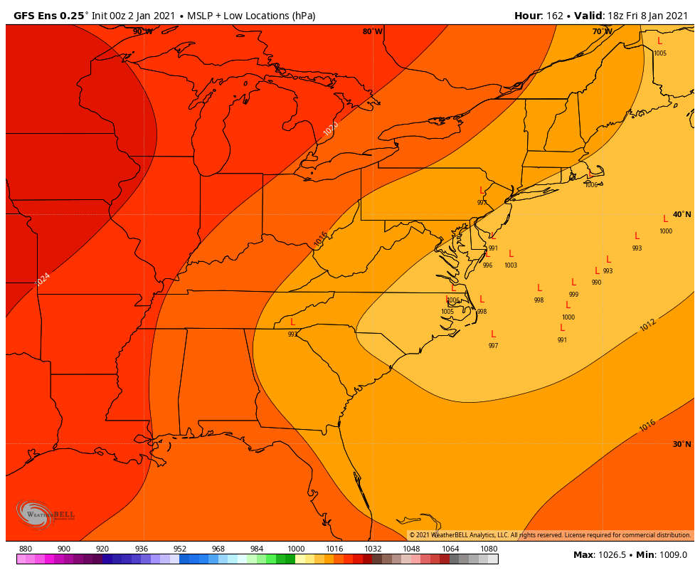
GFS still has that Jan 3 low that the Euro showed and lost but it's a good bit off the coast. Jan 4 2018 redux anyone?? edit: Ninja'd!
-
The ICON had a similar idea with a trailing wave following the cutter but it was all rain. Split the difference and you’ve got a storm! .
-
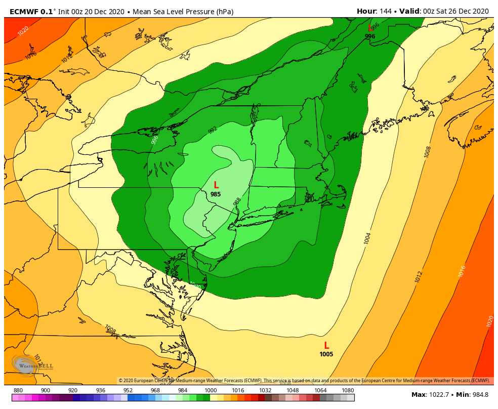
Awesome stuff!! Glad you guys are gonna get a white Christmas
-
Believe so, and apparently it was a bit more consistent with last week's event as well. FWIW it's a good bit less cutteriffic in the LR but then again the GFS seems to have been pretty spot on with the Dec 28 and new years cutters so idk.
-
Hah, I’m leaving on the 3rd over here. Seems like these sort of storms like to move out a day or so In timing, so perhaps you’ll get your wish ! .
-
Haha basically explains my entire time here during that late Dec 2017 pattern that DT kept woofing about. I remember posting all of the ensemble snow means and freaking out about how they were 6"+ 10 days out. In reality? I think I got 0.8" from that pattern. In all honestly I'm not sure how you guys managed to put up with 14 year old me :p but nowadays I reserve my snowfall map postings to just 4 a day way healthier
-
DT's first call, FWIW for western peeps
-
0z Euro is encouraging it seems


-
Is this in regards to having a trailing wave follow up on the arctic front? One singular GEFS model had that on the 12z guidance, but it seems like if that happens, it has some good upside (at least according to that one member)
-
We also saw 8-9 inches on the 15 day mean in December 2017... look how that worked out :p
-
Still out there but the GEFS has a whopping 3lps in the location of the GFS :p Although these lps seem to be overshadowed by a cluster of consensus around the great lakes. Seems like a recipe for nothing? Stale airmass, great lakes low. I guess there's time to iron out the details though

-
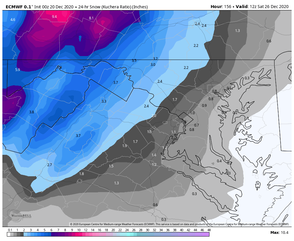
2.5" - 12/16-17. Fun WAA that had 1.5"/hr rates turned sleet/freezing rain. Icebox after the storm. .3" - 1/25 Season Total: 2.8"
-
Had a nice period of -SN/SN to close out the storm with that final band that pivoted through. 2.5" final hope you guys in MD get crushed with this band!!
-
Oh gosh, I'm terribly sorry to hear that something like that happened. My condolences.
-
That's awesome!! Really glad you guys are getting a huge hit out of this, radar looks loaded out there
-
2.3" before changeover. 100% sleet now. How well does sleet tend to accumulate around here? :p