Cobalt
-
Posts
4,908 -
Joined
-
Last visited
Content Type
Profiles
Blogs
Forums
American Weather
Media Demo
Store
Gallery
Everything posted by Cobalt
-

Feb Long Range Discussion (Day 3 and beyond) - MERGED
Cobalt replied to WinterWxLuvr's topic in Mid Atlantic
I agree. 12" on top of the 2.5" I've gotten so far this year would be around the most snow my area has seen in a La Nina in my lifetime (no 95-96 or 99-00 to throw in there of course), and we'd obviously have a chance to get some SECSY/HECSY action with the Modoki Mod Nino + low solar next year -
@CAPE Thanks for the kind words. I know I'm not up to par with some of the expert posters here, but their collective knowledge has certainly helped with my understanding of meteorology these past few years. I checked back to when I first started posting in December 2017 and.. I honestly can't believe you guys managed to bare with me through all my weenieisms :p but I guess everyone has to start somewhere. Snow hardships certainly helped to quell my weenie ways that winter
-
Feb Long Range Discussion (Day 3 and beyond) - MERGED
Cobalt replied to WinterWxLuvr's topic in Mid Atlantic
I know that the accuracy tends to drop off significantly out there, and that's also why I prefaced my post with saying that outside of 3 weeks the weeklies really go out of their way to go towards typical ENSO patterns. Although with that being said, my takeaway from that week 4 h5 map was that it was surprisingly not doing what it did the past few runs at that range, and instead tried to get us back into a favorable progression despite it's biases. Not worth much this far out, but will certainly be super fascinating to follow in about a week or two. yeah basically what CAPE just said -
Feb Long Range Discussion (Day 3 and beyond) - MERGED
Cobalt replied to WinterWxLuvr's topic in Mid Atlantic
Usually you'd expect the weeklies to do its best to revert back to a nina pattern and to pump the SE ridge, but even going a month out the blocking looks decently stout, SE ridge squashed too. Workable look especially when considering Weeklies bias 2 weeks out. -
Snow squall warning time
-
I remember reading somewhere that in terms of tree growing ordinance, a yearly minimum low temp of 22 is similar to areas such as Houston and New Orleans. Anyone up for planting some palm trees?
-
In my short lifetime, Feb/March 2015 is also an epic period that completely slashed the narrative of that winter. 2 warning level events, a bunch of great WWA level events, and of course 3"+/hr rates for 30 minutes in that absurd Valentine's day snow squall. The first time 5th grade me had gotten back into following weather after being sad over March 6 2013 (surprisingly I have 0 recollection of 13/14, unfortunately), but yeah that was also an epic stretch.
-
Feb Long Range Discussion (Day 3 and beyond) - MERGED
Cobalt replied to WinterWxLuvr's topic in Mid Atlantic
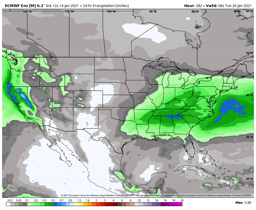
Impressive precip signal for the PSU v2 storm, especially for 12 days out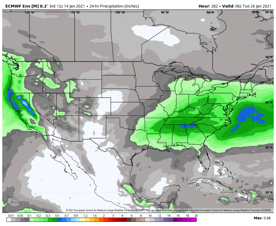
-
Feb Long Range Discussion (Day 3 and beyond) - MERGED
Cobalt replied to WinterWxLuvr's topic in Mid Atlantic
Big cluster of lps that take it through the great lakes, still a cluster of weaker waves that take the lp near our latitude though, but it's certainly not the favored camp. -
Perhaps 17-18 is more fitting, given how scorched North America was in February
-
Feb Long Range Discussion (Day 3 and beyond) - MERGED
Cobalt replied to WinterWxLuvr's topic in Mid Atlantic
Who are you and what did you do with Ji!??? -
Feb Long Range Discussion (Day 3 and beyond) - MERGED
Cobalt replied to WinterWxLuvr's topic in Mid Atlantic
I will say, the 0z EPS centered the snow mean basically identically to that 12z Euro run. Makes sense given that the window looks wayy more favorable for points North -
Feb Long Range Discussion (Day 3 and beyond) - MERGED
Cobalt replied to WinterWxLuvr's topic in Mid Atlantic
Seems like the faster the storm ejects out of the SW, the less of a chance there is for the SE ridge to pump up heights ahead of the storm? At least that's what it seems like given that solution compared to the GFS cutting. Hoping blocking can pull through, but as that Eric Webb tweet I posted earlier, that seems to be fleeting a bit -
Feb Long Range Discussion (Day 3 and beyond) - MERGED
Cobalt replied to WinterWxLuvr's topic in Mid Atlantic
If there's one thing we're good at, it's front end thumps -
Feb Long Range Discussion (Day 3 and beyond) - MERGED
Cobalt replied to WinterWxLuvr's topic in Mid Atlantic
-
Since we're on the topic of snowless periods.. how does the early 14/15 winter pattern compare to what we're going through right now? Obviously the pattern we're in has for sure been serviceable, but I'm mainly contrasting that winter and this one because it seems like Feb '15 essentially flipped a switch after a super dormant period with not much domestic cold. I know that was a PAC based shift, but before that from late Nov to late January (outside of the fluke warning level clipper), it was basically a snowless pattern for 60 days, going all the way into what would be the peak climo of late January. What went into that big shift?
-
Feb Long Range Discussion (Day 3 and beyond) - MERGED
Cobalt replied to WinterWxLuvr's topic in Mid Atlantic
Posting this for reference to check in 5 days, but the GEFS keeps muting any cold within day 10. Makes sense right now given no EPO and a fight between the western trough and the -NAO, but here, given that we'll have the EPO to help bleed the cold in, if this look gets muted and warms us up DESPITE some PAC help.. then yeah we're probably screwed. Also a check to see if the progression keeps getting delayed..
-
Putting on my Weather Will cap but.. PSU v2 storm looks ripe on the snow mean.. as good of a signal as you can get this far out As for the 21/22 threat.. this isn't actually a disappointing mean. We're south of the center of the mean and the 850s are borderline, but we have blocking on our side at the very least. Glad we're dealing with a signal rather than a flicker so to speak.
-
The high should hold right? Thats why we pay big bucks for blocking Primary goes into Wisconsin and there's still blue over our area, so probably lol
-
Para GFS does the same split that big brother GFS does, meanwhile the ICON has a progression similar to the Euro.
-
DT's take on the GEFS earlier today. Interesting seeing the EPS flip-flop with the GEFS as being the coolest/most wintry ensemble now as well.
-
Here's the ensemble 850 temps during the peak of precip (198hrs) Seems pretty darn borderline, however, here is the same panel at 0z Even with the SER flexing itself ahead of time, the 850s still are manageable. Surface temps aren't the best, but it's still not a bad place to be this far out. This seems like a characteristic of overrunning, no? Borderline 850s and a thump of moisture. Certainly beats looking at a South Carolina bullseye at this length out, at least imo.
-
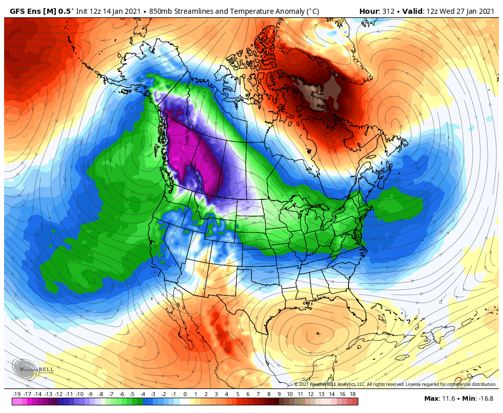
Somehow despite the ridging being extra prevalent through hrs 200-280, the 12z GEFS actually looks on par if not a tiny bit better at hr 288 when compared to 6z. Curious as to if a few outliers are pumping up that ridge during that day 10 time. I'd imagine they're doing what the op GFS did from 18z through 6z and are just losing the -EPO?
-
Control concurs with a decent event. EPS seems to take the snow mean to the north of us, but that's to be expected at this point. With the block we're def in the game, hope that look holds.
-
Para GFS is super close to a great solution for us.. more expansive cold as well as a larger snow shield, just a bit too North.