Cobalt
-
Posts
5,216 -
Joined
-
Last visited
Content Type
Profiles
Blogs
Forums
American Weather
Media Demo
Store
Gallery
Everything posted by Cobalt
-
I remember it being the only model to hold onto the Feb 7th system as well. Pretty nice run it's on.
-
ICON panels still coming out, but it looks pretty darn juiced. Nice to see models not lose any precip with some actually getting wetter as we get towards 40hrs until onset. Gives us a cushion for when/if they lose a bit of juice as they have so far during this winter in short range.
-
Some of those 1hr panels have 0.2-0.3" of precip fall, basically all sleet. Not sure I've ever seen sleet accumulate as fast as snow before, but regardless that would be ~0.6-1" of sleet an hour? Can't imagine seeing that happen, but it would be quite the sight.
-
NAM has 850s at -3 to -5 at hr 45, meanwhile 700mb temps are +3. Need to see the charts on that, it's likely not right, but that would be an unholy sleet bomb for sure.
-
:/
-
Thursday's system is outside of the Day 3-7 Hazards Outlook, but this shows the potential for cold following the event. Might be a deep winter look if a majority of the subforum avoids rain or temps shooting up on Friday.
-
Yeah, I guess the main takeaway is that it starts everyone EZF north as snow. Wave 2 looked pretty potent but obviously it doesn't go out to that range.
-

Feb Long Range Discussion (Day 3 and beyond) - MERGED
Cobalt replied to WinterWxLuvr's topic in Mid Atlantic
I think your idea of the lack of a temperature gradient plays into it too. Whether it's the PAC torch lingering from November or warm SSTs in the Atlantic, we really haven't had much of a major fluctuation in temperatures. No temps in the 60s whatsoever (not many days peaking over 50 either), but not many subfreezing highs either. The entire period from Jan 15 to Feb 15 was basically as climo as you could manage in a winter. Now that we actually have a major temp gradient into the country now, we're finding ourselves in a potential snowy setup in a rather imperfect pattern. This is closer to banter/speculation now, but I've wondered how the major loss of snowpack plays into things too. Not as of recently, but with how rapidly the Dec 16-17 snowpack melted off with the Christmas Eve deluge. That basically wiped the 30"+ snowpack away for the areas that got that big of a snowfall. Those same areas would've gotten a snowpack efresher with the Jan 3 system, but I just remember the potential pattern change being delayed shortly after the rainstorm came into range with it being modeled to erase that snowpack. Im not too informed on how that would've impacted January, and I imagine it wouldn't have done much, but surely losing that square mileage of snowpack factored into the lack of any major temperature gradient in the Eastern US. -
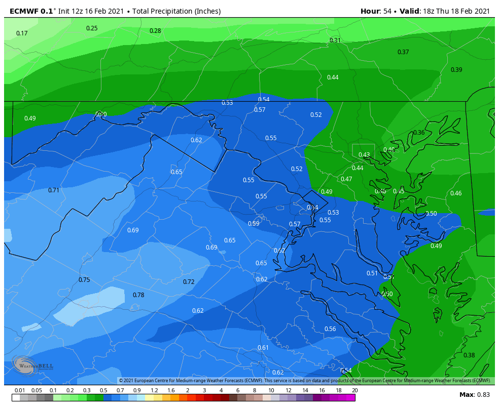
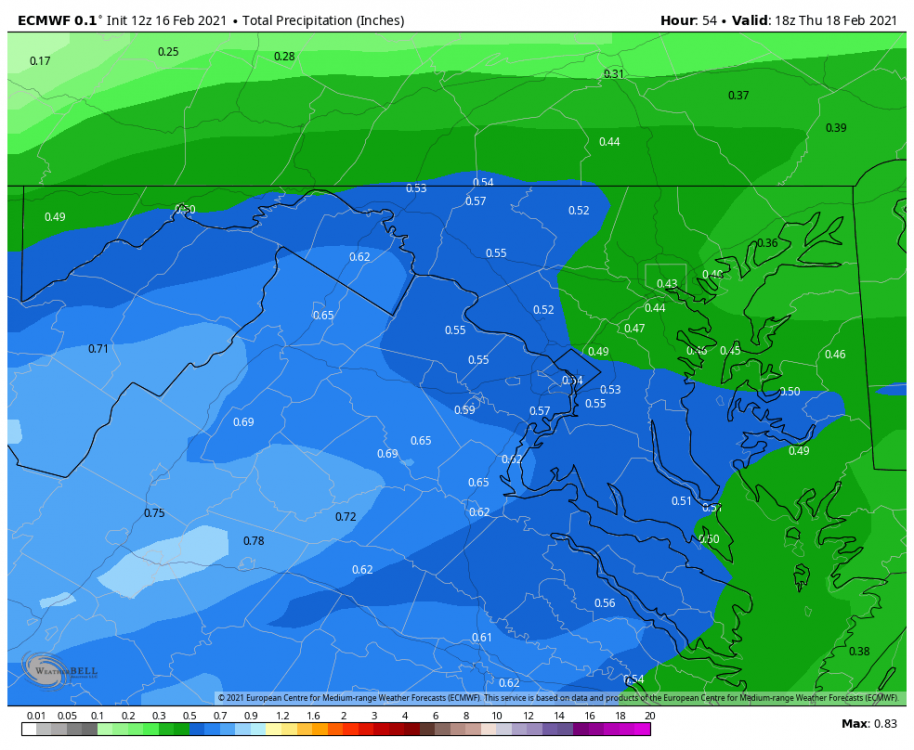
As others have mentioned, 850s/700s basically hang on and keep DC and Northwest snow outside of a few 1hr panels. Regardless, here's how much falls before 850s get borderline. Pretty exciting stuff.
-
Changes back to snow for a good bit of the area through 05z Friday. Great run for most! Glad it's catching on to the initial thump being faster/wetter.
-
His pep talk for the SE crew would be equally as inspiring

-
RGEM, GFS Para (and now Canadian) also pick up on some form of backbuilding with light snow bands all the way out to late Friday/early Saturday. Not really sure why they do this, unless it's part of the costal development? Regardless it would be a period of light snow after the main system departs to freshen up the snowpack/sleet.
-
Feb Long Range Discussion (Day 3 and beyond) - MERGED
Cobalt replied to WinterWxLuvr's topic in Mid Atlantic
-
Wow, GFS Para tries to changeover areas NW of DC after initial mixing (some other guidance seems to be suggesting this too), but it adds 3-6" for those areas with that secondary burst of snow.
-
Feb Long Range Discussion (Day 3 and beyond) - MERGED
Cobalt replied to WinterWxLuvr's topic in Mid Atlantic
Is there any reason as to why it's so slow with onset of precip? It's been heading that way for most of the day, which is at the same time going against other guidance. But yes, the thermals overhead improving still inspire some confidence for the general subforum even with a drier solution. -
Feb Long Range Discussion (Day 3 and beyond) - MERGED
Cobalt replied to WinterWxLuvr's topic in Mid Atlantic
It still seems to be an outlier on how slowly it takes to get precip into our general area. I'd imagine that hurts us a good bit as was mentioned with the 18z Euro discussion. -
Feb Long Range Discussion (Day 3 and beyond) - MERGED
Cobalt replied to WinterWxLuvr's topic in Mid Atlantic
Yeah, it's pretty apparent to see those differences in timing when comparing the GFS to the Euro. GFS already has 0.3-0.4" of precip as of 12z Thursday in areas where the event hasn't even started on the Euro. I believe it's the slowest of all OPs at the moment. -
Feb Long Range Discussion (Day 3 and beyond) - MERGED
Cobalt replied to WinterWxLuvr's topic in Mid Atlantic
This is how much QPF falls before 850s give way (and 700s shortly after) for DC and southeast. Areas NW hold onto snow longer.
-
Feb Long Range Discussion (Day 3 and beyond) - MERGED
Cobalt replied to WinterWxLuvr's topic in Mid Atlantic
Euro continued the trend of having confluence linger north of us (which hasn't stopped for maybe the past 48-72hrs), but it seems like the SW might be a bit amped and it's a bit slower, allowing heights to rise a bit in front. At least that's the explanation that I can see, since the GFS is like 6hrs faster and doesn't allow heights to rise as much in front. -
Feb Long Range Discussion (Day 3 and beyond) - MERGED
Cobalt replied to WinterWxLuvr's topic in Mid Atlantic
We don't get NAMed anymore, we merely get runs that would be deemed ICONic -
Feb Long Range Discussion (Day 3 and beyond) - MERGED
Cobalt replied to WinterWxLuvr's topic in Mid Atlantic
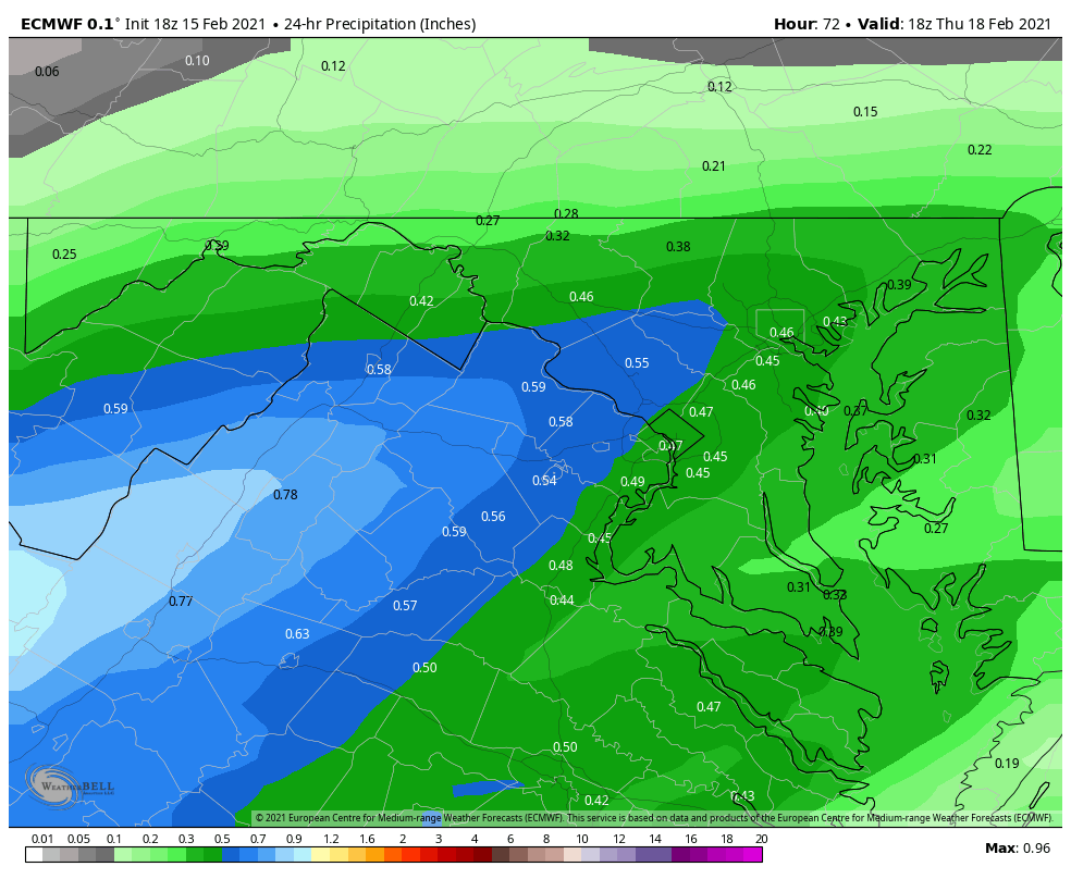
6z GFS drops 0.75"+ QPF for most of the area before any midlevel gets above freezing (at DCA/I-95 and points SE that is). 1" QPF jackpots in there too, and I'll leave it at that. -
Feb Long Range Discussion (Day 3 and beyond) - MERGED
Cobalt replied to WinterWxLuvr's topic in Mid Atlantic
Looping what the GFS does with today's system for Wednesday is super fascinating. That system wants to linger for as long as it can, and the trend isn't stopping. That's for sure contributing to the more suppressed look ahead of the Thursday system. Heights a fair bit lower ahead compared to 0z, which were lower than 18z, etc. At this point with our previous systems that got suppressed from flush hits (like Jan 28), this trend was screwing us over, but now it wants to get us into a somewhat decent look lol. -
Feb Long Range Discussion (Day 3 and beyond) - MERGED
Cobalt replied to WinterWxLuvr's topic in Mid Atlantic
Canadian has stuck with a progression that would fit your thinking. Check out hour 102. It's night and day different. -
Feb Long Range Discussion (Day 3 and beyond) - MERGED
Cobalt replied to WinterWxLuvr's topic in Mid Atlantic
the NAM and RGEM are.. just a tiny bit different at HR 84. Dunno, RGEM has been pretty good with figuring out the waves running along the boundary. Might've spent all it's energy on that and be out of gas though lol. But yeah it's a good bit colder at all levels and takes a more favorable track -
PDII maybe? That's actually kind of sad to think about. I guess it's what we get to be able to have 99% of our storms be 2" of slop to rain events with the other 1% being the big dog HECS storms that melt away after a week. What an area