

Cobalt
-
Posts
4,908 -
Joined
-
Last visited
Content Type
Profiles
Blogs
Forums
American Weather
Media Demo
Store
Gallery
Everything posted by Cobalt
-

January Storm Term Threat Discussions (Day 3 - Day 7)
Cobalt replied to WxUSAF's topic in Mid Atlantic
Not smart enough to analyze this but just figured I'd provide this here -
This weather stuff is easy.
-
January Storm Term Threat Discussions (Day 3 - Day 7)
Cobalt replied to WxUSAF's topic in Mid Atlantic
The off hour EPS runs are still barely out of range (I completely forgot the storm is still 6 days out until seeing this), but it seems like the EPS is insistent on a good slug of moisture. Here's the last panel of the run 6z GEFS looks pretty similar at this time too, and that certainly didn't have a North Carolina jackpot look on it's means -
January Storm Term Threat Discussions (Day 3 - Day 7)
Cobalt replied to WxUSAF's topic in Mid Atlantic
Goodnight, everyone. -
January Storm Term Threat Discussions (Day 3 - Day 7)
Cobalt replied to WxUSAF's topic in Mid Atlantic
That's actually pretty great agreement lol, I'd imagine that the 18z EPS looked juicier because it had more members subscribing to that idea, while the GEFS is straying from going away from it's op. In terms of an actual big hit in NC like what the op showed, I could only see one run that had an actual decent swath of snow and hit that far south. Far more had no storm at all compared to that, or a storm but it jackpotted us or Central VA, or a super weak storm that dotted snow into NC/VA. Getting near that hr 150 threshold too so hoping more members pick up on the storm. -
January Storm Term Threat Discussions (Day 3 - Day 7)
Cobalt replied to WxUSAF's topic in Mid Atlantic
Wettest 24hr period on the 0z GEFS vs wettest 24hr period on the 18z GEFS You get the picture. Certainly no south trend on the GEFS. -
January Storm Term Threat Discussions (Day 3 - Day 7)
Cobalt replied to WxUSAF's topic in Mid Atlantic
The costal huggiest panel for the 18z GEFS vs 0z '\ Definite improvement I'd say. -
The time that we actually have a blizzard on our doorstep (whether it be next week or next decade), it'll be fun to look back at what snow starved weenies we can truly be
-
January Storm Term Threat Discussions (Day 3 - Day 7)
Cobalt replied to WxUSAF's topic in Mid Atlantic
Seems like the GEFS doesn't agree all too much with the GFS. It's encouraging when the ensembles take a step in the right direction despite the operational taking a step back. Precip/snow maps still rolling out -
January Storm Term Threat Discussions (Day 3 - Day 7)
Cobalt replied to WxUSAF's topic in Mid Atlantic
I think it's light teal -
January Storm Term Threat Discussions (Day 3 - Day 7)
Cobalt replied to WxUSAF's topic in Mid Atlantic
Canadian has our storm at least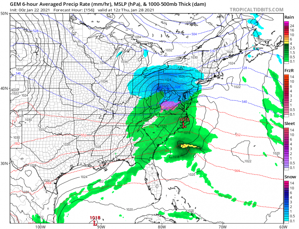
-
It's funny how snow starved we are that now we have blatant trust issues even when a model shows a clear bullseye over us. PSU's (great) post about how suppression isnt the worry for the day 6 storm immediately flipped my mindset to worrying about being too far south for the goods lol.
-
January Storm Term Threat Discussions (Day 3 - Day 7)
Cobalt replied to WxUSAF's topic in Mid Atlantic
When will the black arrows over the water arrive at my house?? -
The big thing though is that this is trending on all guidance, even ops. Perhaps once we get into 3k or 12k NAM range that the WAA trends in our favor, but as of now we're probably losing that part of the storm. At the same time, it's GFS/GEFS vs everything else for giving us a decent WWA level event on the backend of the storm, but I guess we gotta hope for that.
-
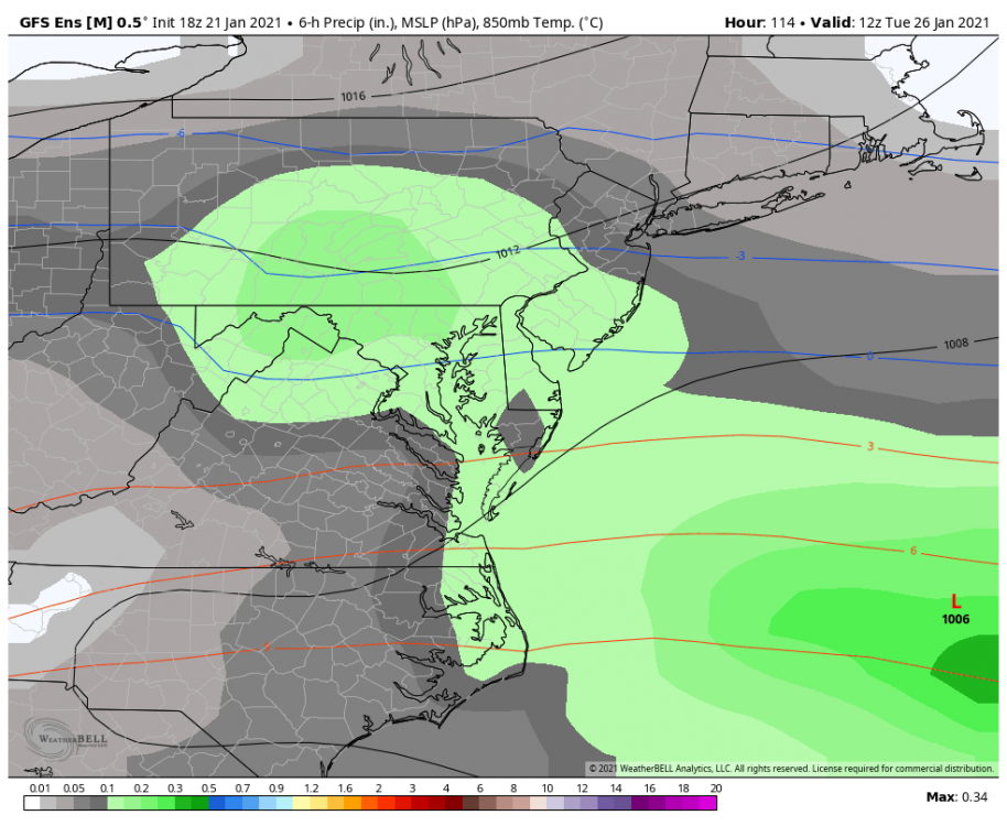
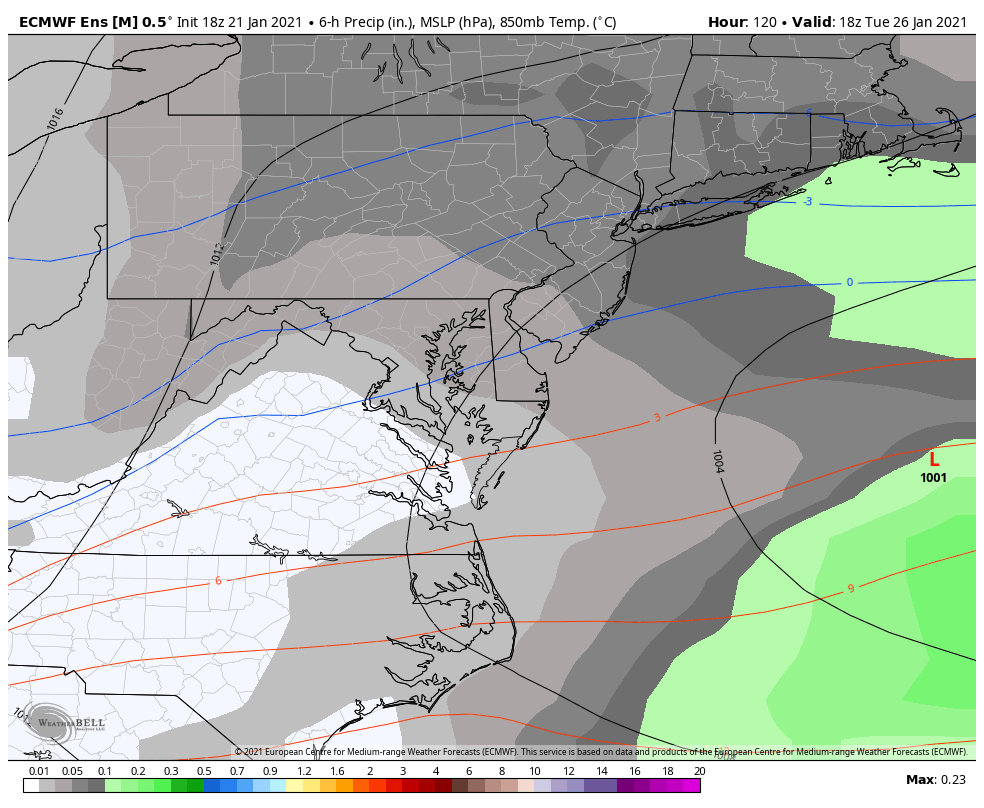
As I mentioned earlier with the GFS/GEFS, it seems like that group raises heights in front in turn for the system to come in and change over to snow at the end. The Euro/EPS likes none of this idea. I'd imagine the general DC area would fare better with the GFS option, as 850s crash to -3 with moderate precip still in the area. With the Euro, the WAA was as borderline as you could get, snowing at 0/-1 850s. Here's the EPS' precip depiction as the system leaves us Meanwhile, the GEFS has a fair bit more precip. Watch for this trend either on the ops or the ensembles. Given the blocking, we could totally score on an icy mix to snow scenario, especially in comparison to the torched WAA start. If only we had Arctic air in place..

-
January Storm Term Threat Discussions (Day 3 - Day 7)
Cobalt replied to WxUSAF's topic in Mid Atlantic
We're still 12-24hours out until the 6z and 18z EPS will go out far enough to cover the 28th storm but.. 18z EPS has the juiciest look yet. Decent consensus on a slug of moisture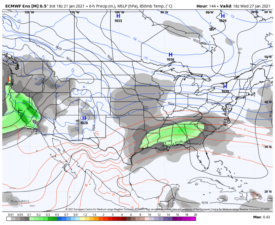
-
Or history might suggest that the GFS isnt done with the south shift and shifts a few hundred miles, setting it up perfectly for you guys *ahem December 2018*
-
January Storm Term Threat Discussions (Day 3 - Day 7)
Cobalt replied to WxUSAF's topic in Mid Atlantic
I guess a step back from 12z, but still a good signal I was actually thinking about your rule about where we want a storm for it to adjust north last minute. Seems like even the suppressed GFS is in a decent spot for us. Shades of those few Euro runs for Jan 2016 where it completely jackpotted Richmond.
-
January Storm Term Threat Discussions (Day 3 - Day 7)
Cobalt replied to WxUSAF's topic in Mid Atlantic
Reminds me of something... -
Seems like it succeeded?? Moderate snow back into DC at 114.
-
January Storm Term Threat Discussions (Day 3 - Day 7)
Cobalt replied to WxUSAF's topic in Mid Atlantic
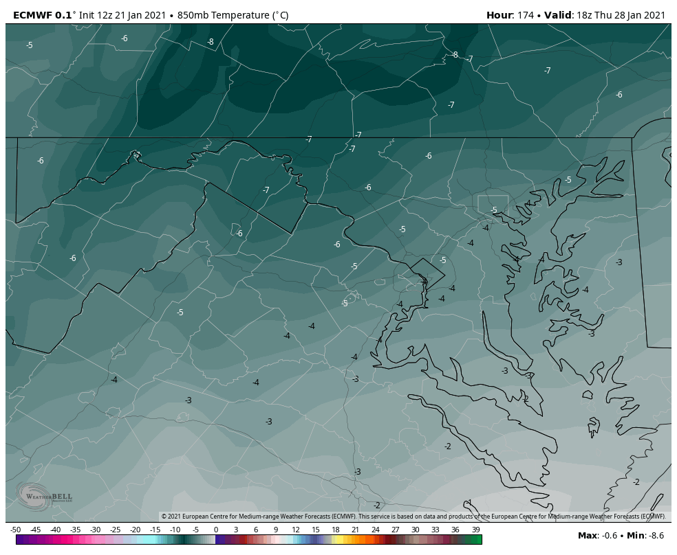
Consider the 850s during the heaviest part of the storm. The 850s get even colder after the low pulls offshore a bit (still snowing though). This certainly wouldnt be 10:1, especially for the elevated areas and places where their average ratios are already 12:1 or more.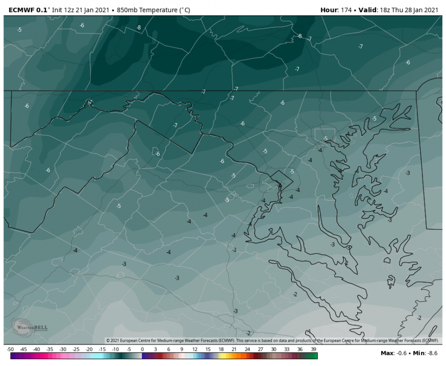
-
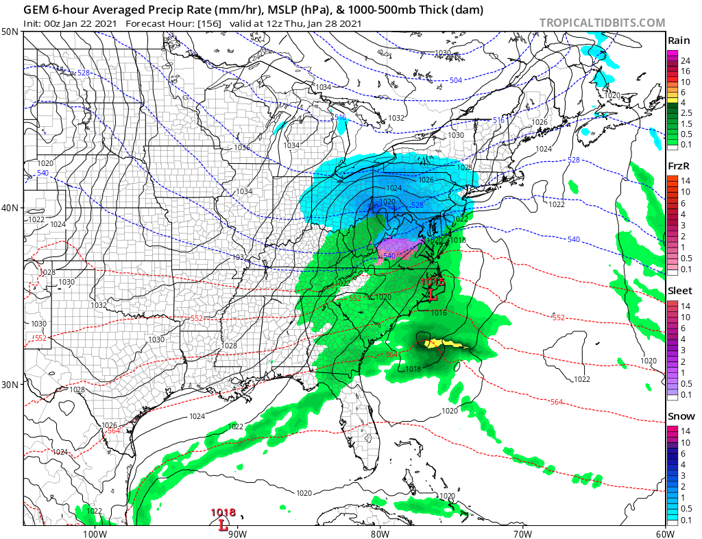
January Storm Term Threat Discussions (Day 3 - Day 7)
Cobalt replied to WxUSAF's topic in Mid Atlantic
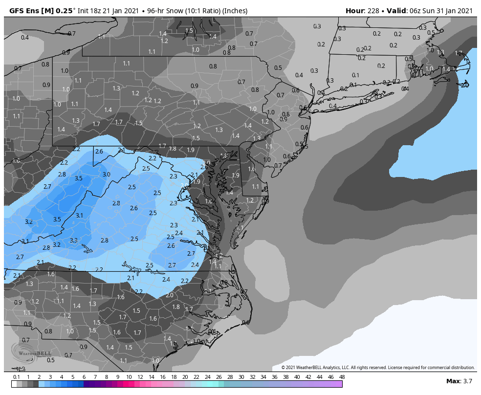
Remember that this includes snow from the Monday system. Here's what seems to be a better map. Also that doesnt include the fact that it's a fluff bomb for points NW.thumb.png.1114eca85b46ee41141207ecf8904b76.png)
-
Feb Long Range Discussion (Day 3 and beyond) - MERGED
Cobalt replied to WinterWxLuvr's topic in Mid Atlantic
Jan 2000 is one of the top analogs based on the GEFS for days 8-14. Also Feb 1994. -
Just like the GFS, the Euro takes a fair portion of our area back to snow. 1 more shift south like that and I'd imagine some parts of our subforum (you know who you are) would be shoveling this
-
March 5 2015 as well. 40s and rain changing to heavy snow. I think IAD recorded ~9 inches of snow in that.


.png.84d521e0710fc6f99c5cca1b046fe58f.png)
