Cobalt
-
Posts
4,908 -
Joined
-
Last visited
Content Type
Profiles
Blogs
Forums
American Weather
Media Demo
Store
Gallery
Everything posted by Cobalt
-

January Storm Term Threat Discussions (Day 3 - Day 7)
Cobalt replied to WxUSAF's topic in Mid Atlantic
Oh okay yeah the precip was still rolling with those panels, keeps DC and even immediate SE below 30 degrees but precip is spotty there, but ICON on board with a good storm. Pretty sure precip is still going in this panel for a fair bit of the subforum, but it's the ICON so ¯\_(ツ)_/¯ -
January Storm Term Threat Discussions (Day 3 - Day 7)
Cobalt replied to WxUSAF's topic in Mid Atlantic
Pretty great opener to 12z. Wonky surface depiction (the snow in SE VA is from Thursday), but my takeaway was that at precip onset, temperatures are actually pretty cold, mid 20s for a majority of the subforum -
January Storm Term Threat Discussions (Day 3 - Day 7)
Cobalt replied to WxUSAF's topic in Mid Atlantic
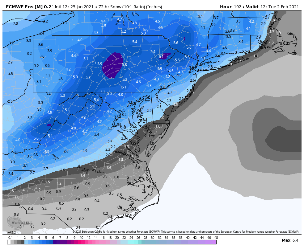
Hah that's not the control, but that too basically keeps the same idea. Despite the loss in snow mean the consistency is great -
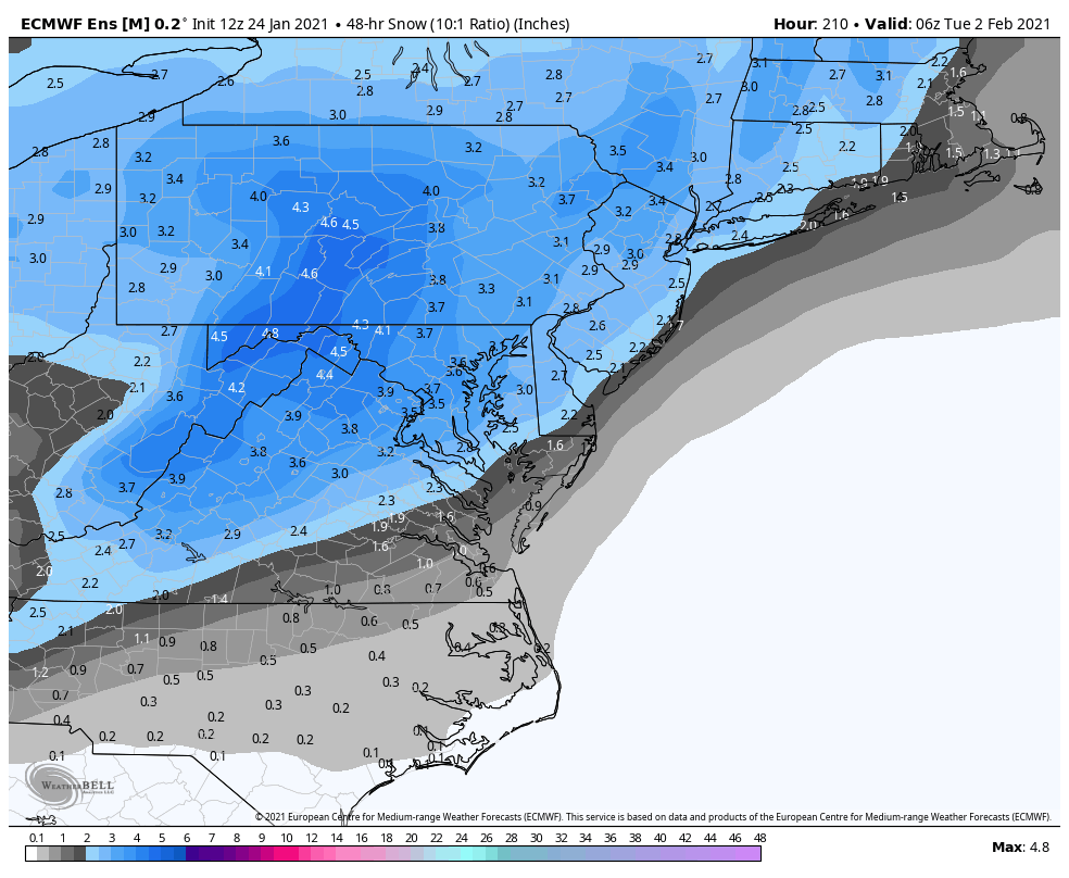
January Storm Term Threat Discussions (Day 3 - Day 7)
Cobalt replied to WxUSAF's topic in Mid Atlantic
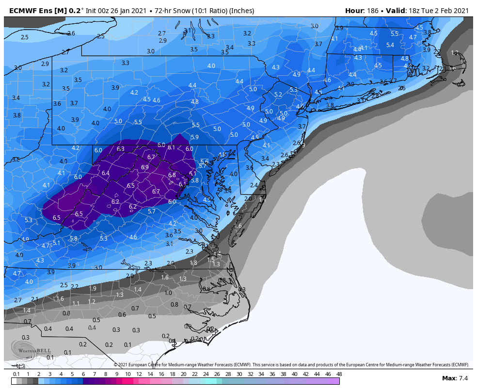
Here's the snow mean to go with it..
-
January Storm Term Threat Discussions (Day 3 - Day 7)
Cobalt replied to WxUSAF's topic in Mid Atlantic
Precip panels are running slow but def juicier, as well as a lot more members with a similar transfer to the op Euro. Great trends all around at the range you'd want to see them at -
January Storm Term Threat Discussions (Day 3 - Day 7)
Cobalt replied to WxUSAF's topic in Mid Atlantic
I hope the euro is as persistent and stubborn as it was for Thursday non storm. I mean the storm starts in 120 hours. If we get a nothing burger out of this.. the Thursday threat made sense since half of the models converged entirely but this has at least some snow on most of the models.. I'd assuume that in 24-48 hours time we will know if this thing has legs for us or legs to run away from us -
January Storm Term Threat Discussions (Day 3 - Day 7)
Cobalt replied to WxUSAF's topic in Mid Atlantic
I mean.. it has precip into Virginia at 120 hours out.. technically 5 days away?? -
January Storm Term Threat Discussions (Day 3 - Day 7)
Cobalt replied to WxUSAF's topic in Mid Atlantic
Previous run had the WAA snow falling apart too.. interestingly enough its on its own in that regard it seems -
January Storm Term Threat Discussions (Day 3 - Day 7)
Cobalt replied to WxUSAF's topic in Mid Atlantic
Pretty similar. Snows from hr 132 to hr 186 and still going lol. We could only hope -
January Storm Term Threat Discussions (Day 3 - Day 7)
Cobalt replied to WxUSAF's topic in Mid Atlantic
Para GFS looks pretty fun -
January Storm Term Threat Discussions (Day 3 - Day 7)
Cobalt replied to WxUSAF's topic in Mid Atlantic
No kidding! I feel like we're due for one to go our way though.. The 12z Euro run reminded me a lot of what the March 2017 Miller B storm turned out to be (half screw job), but that was a few tweaks away from working out big time. Glad to be tracking again though. -
January Storm Term Threat Discussions (Day 3 - Day 7)
Cobalt replied to WxUSAF's topic in Mid Atlantic
Fringed! -
I mainly just remember it being progged to be a snow to rain event from like 5 days out. Off and on 3-5" and 1-3" looks but it juiced up pretty well, typical CAD held serve and there was some sleet alongside it too.
-
Not sure if this is the right place to sidetrack this thread but.. I'm surprised people don't mention Feb 20 2019 with decent snowfall in that winter. I got 4.0" on the dot here in McLean, so surely a 2-4" event wouldn't be the biggest since the event prior to that. Anyways, I digress, 18z held serve, hoping for the best for everyone here!!
-
January Storm Term Threat Discussions (Day 3 - Day 7)
Cobalt replied to WxUSAF's topic in Mid Atlantic
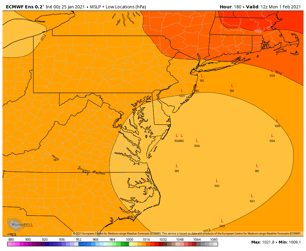
The primary drives through there and transfers offshore. 0z took way more lps on a visit through Michigan and western New York so that's actually not bad lol. Considering the cold air and CAD signal I guess it's advantageous for us to have it in Ohio/Indiana as PSU mentioned we wanted with the Thursday event. -
January Storm Term Threat Discussions (Day 3 - Day 7)
Cobalt replied to WxUSAF's topic in Mid Atlantic
Some good hits in this mean.. still favors NW but given the seasonal trends we're in a good spot this far out Lp cluster Don't look at the Euro control lol
.thumb.png.f7d7b8c1eccf4de85d87298f1e58ecc7.png)
-
January Storm Term Threat Discussions (Day 3 - Day 7)
Cobalt replied to WxUSAF's topic in Mid Atlantic
Confirms my thoughts in regards to the 0z low camp and the improved look on the 6z. Way less lows track into the great lakes and even a few transfers take it off the coast of NC. Good trends, and to be expected at this range. During this time with the Thursday threat the Euro fully lost the storm IIRC. -
Can someone explain what in the world the RMP model is?? Lovechild of RAP and Deep Thunder??
-
January Storm Term Threat Discussions (Day 3 - Day 7)
Cobalt replied to WxUSAF's topic in Mid Atlantic
Seems like a camp of lows at the 0z EPS favored a transfer in a pretty decent spot.. 6z looked even better with a bit more confluence and a weaker lp before transfer (but of course it only goes out to 144, which also shows how far out this is lol). Will be interesting to see the look at this panel for 12z, I'd expect some similar looking lps, maybe an improved camp of them.
-
January Storm Term Threat Discussions (Day 3 - Day 7)
Cobalt replied to WxUSAF's topic in Mid Atlantic
12z Para agrees, pretty decent hit for many DC and NW. Even though the GFS camp seems to not want to transfer to the coast until way late, it still has some decent front end snow with that retreating coldish airmass. -
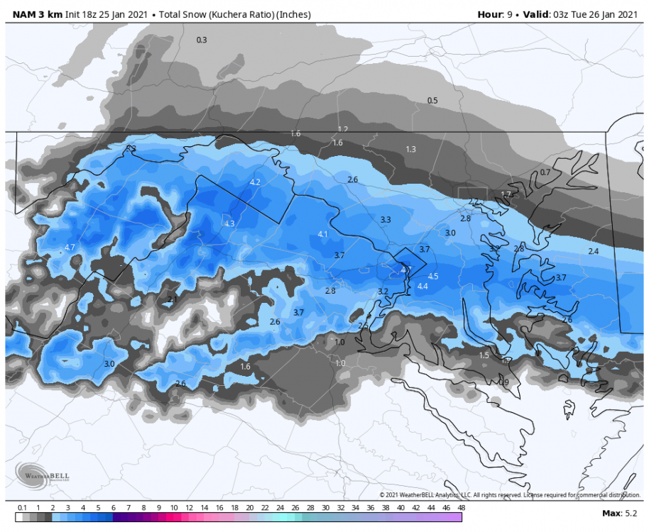
January Storm Term Threat Discussions (Day 3 - Day 7)
Cobalt replied to WxUSAF's topic in Mid Atlantic
This captures the full period I believe (initial thump and then costal redevelopment??)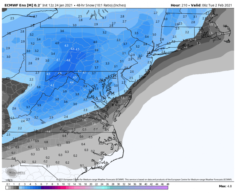
-
January Storm Term Threat Discussions (Day 3 - Day 7)
Cobalt replied to WxUSAF's topic in Mid Atlantic
I'll be the first to say it but.. right where we want it??
-
January Storm Term Threat Discussions (Day 3 - Day 7)
Cobalt replied to WxUSAF's topic in Mid Atlantic
Here's the probability of 1" of snow just to get the full picture: Compared to 18z and yeah you can tell which is better.thumb.png.dea8343403fe10f51f5bd63a2c24a5fb.png)
.thumb.png.3a1118f7e9af012b0655d6ab529f7367.png)
-
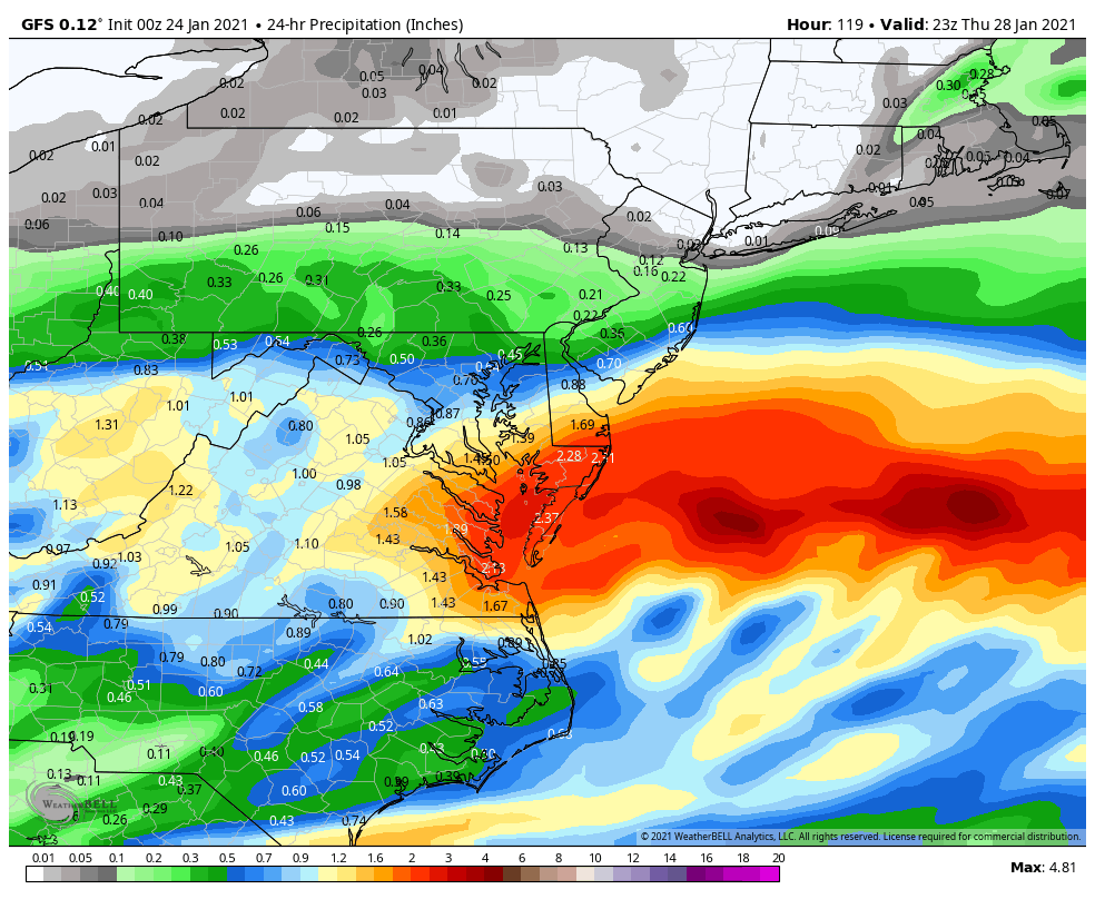
January Storm Term Threat Discussions (Day 3 - Day 7)
Cobalt replied to WxUSAF's topic in Mid Atlantic
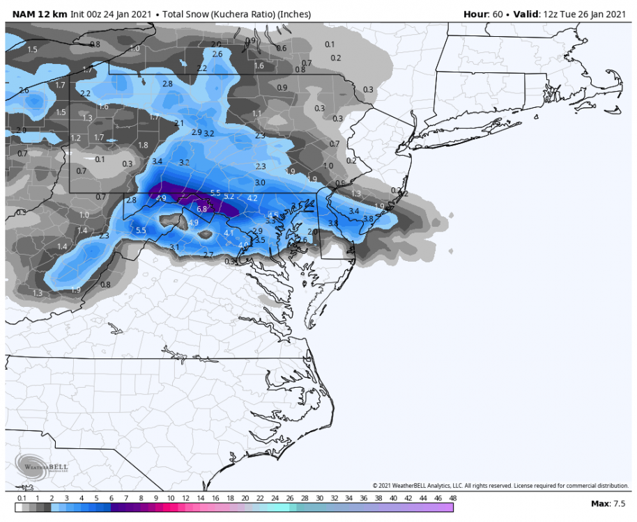
GFS is not gonna get a handle on the snow maps even with Kuchera.. using a precip map shows that yeah its pretty juicy for many.
-


.png.cb1937e4941b4dcb8636fbf6b0021968.png)


.png.d0100294bfe7edf1cb8eb623a0ceb50a.png)
.png.a3cec5c88ae25c9a8b4ab9e848f08704.png)