Cobalt
-
Posts
4,908 -
Joined
-
Last visited
Content Type
Profiles
Blogs
Forums
American Weather
Media Demo
Store
Gallery
Everything posted by Cobalt
-

January Storm Term Threat Discussions (Day 3 - Day 7)
Cobalt replied to WxUSAF's topic in Mid Atlantic
This is actually NW of 12z lol Control is still a bomb too. Weird that the EPS went up pretty well compared to it's Op brother.
.thumb.png.ad75e029ce0d539c72617a50eb8ffcf4.png)
-
January Storm Term Threat Discussions (Day 3 - Day 7)
Cobalt replied to WxUSAF's topic in Mid Atlantic
The EPS looks pretty similar to 12z, if not a tiny bit North. Certainly not a step back. I'd imagine that ensembles are pretty decent at this range. -
January Storm Term Threat Discussions (Day 3 - Day 7)
Cobalt replied to WxUSAF's topic in Mid Atlantic
GFS transfer still gets Norther Maryland into some of the costal snow.. let's see if it stalls there -
January Storm Term Threat Discussions (Day 3 - Day 7)
Cobalt replied to WxUSAF's topic in Mid Atlantic
Considering the worry of fringe.. that's a decent run. Still basically WSW snows for DC and west, Northern Maryland gets a great snow -
January Storm Term Threat Discussions (Day 3 - Day 7)
Cobalt replied to WxUSAF's topic in Mid Atlantic
The control is a full on Virginia special.. costal is pivoting bands up through DC at this time with temps in the mid 20s. Nuts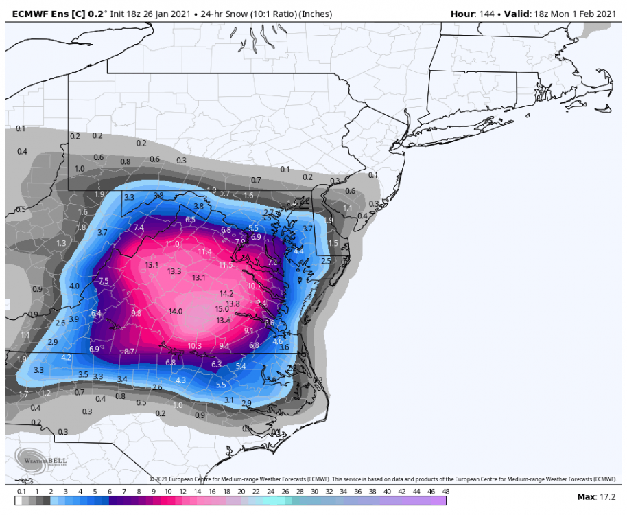
-
January Storm Term Threat Discussions (Day 3 - Day 7)
Cobalt replied to WxUSAF's topic in Mid Atlantic
As far as I remember, the actual costal feature of that storm was found pretty far in, maybe like 3-4 days beforehand. Before that the WAA was looking like the main event, and it continued to trend warmer, putting DC out of the game before the costal part got latched onto. -
January Storm Term Threat Discussions (Day 3 - Day 7)
Cobalt replied to WxUSAF's topic in Mid Atlantic
18z snow mean.. Compared to 12z.. Precip for these panels sucks to compare because it's only 24 hour intervals on WxBell, but the snow mean should suffice There's a word for this but I can't seem to find it... anyone?.thumb.png.1ed066e74211383ec95feb5fed6329d0.png)
-
January Storm Term Threat Discussions (Day 3 - Day 7)
Cobalt replied to WxUSAF's topic in Mid Atlantic
Definite improvement. Kuchera is even higher, and we get into the costal action this time. It's very obviously bleeding to the Euro. Even then.. if you find this a disaster, you need to move to a place that gets way more snow, preferably out of this subforum's range. -
January Storm Term Threat Discussions (Day 3 - Day 7)
Cobalt replied to WxUSAF's topic in Mid Atlantic
GFS has 4-6" from the WAA alone, with more to the North of us as the costal gets cranking. Def a step in the right direction, this feels like Saturday's trends for the Thursday event where the GFS slowly sank SE but we had that glimmer of hope -
January Storm Term Threat Discussions (Day 3 - Day 7)
Cobalt replied to WxUSAF's topic in Mid Atlantic
ICON at hr 117. Compared to previous run it's rather similar, hard to compare since it actually scoots the lp in faster, but the lp seems maybe like 25-50 miles north and somewhat weaker than the 12z run. Decent WAA thump with it too -
January Storm Term Threat Discussions (Day 3 - Day 7)
Cobalt replied to WxUSAF's topic in Mid Atlantic
Improvement -
January Storm Term Threat Discussions (Day 3 - Day 7)
Cobalt replied to WxUSAF's topic in Mid Atlantic
If we're taking the Icon's snowfall duration into consideration.. are you talking about this weekend or the weekend after that? -
January Storm Term Threat Discussions (Day 3 - Day 7)
Cobalt replied to WxUSAF's topic in Mid Atlantic
NAM range for onset of WAA might make sense.. by then the track before costal is pretty set and then the details that'll come into med/short range will just be the stuff after. Got a long 24-48hrs to go! -
No better time for dancing than after a pity party. Still lots of time for this to go wrong, but nevertheless the good vibes will continue. We'll all float on, good news is on the way
-
That's not what I meant in the slightest

-
January Storm Term Threat Discussions (Day 3 - Day 7)
Cobalt replied to WxUSAF's topic in Mid Atlantic
-
January Storm Term Threat Discussions (Day 3 - Day 7)
Cobalt replied to WxUSAF's topic in Mid Atlantic
The cluster! Ninja'd, but it doesnt matter, thats a great agreement and gives some leeway too. Great run coming up
-
January Storm Term Threat Discussions (Day 3 - Day 7)
Cobalt replied to WxUSAF's topic in Mid Atlantic
If you're considering the end of the storm, yeah. Transfer happens near hr 130. Still def EPS range though, the next 24-48 hours will really show if the Euro can nail this thing or if it completely lets go. WDI unloading on us to make up for the past 5 years?? -
I was told it might snow Monday? What's the Euro showing?
-
January Storm Term Threat Discussions (Day 3 - Day 7)
Cobalt replied to WxUSAF's topic in Mid Atlantic
That seems correct. Also a great overall bump in the snow mean. It's forced to be 5 days but it should be uncontaminated from other events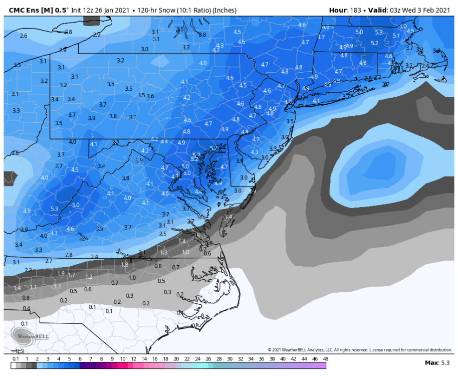
-
January Storm Term Threat Discussions (Day 3 - Day 7)
Cobalt replied to WxUSAF's topic in Mid Atlantic
How does this compare to 0z? -
January Storm Term Threat Discussions (Day 3 - Day 7)
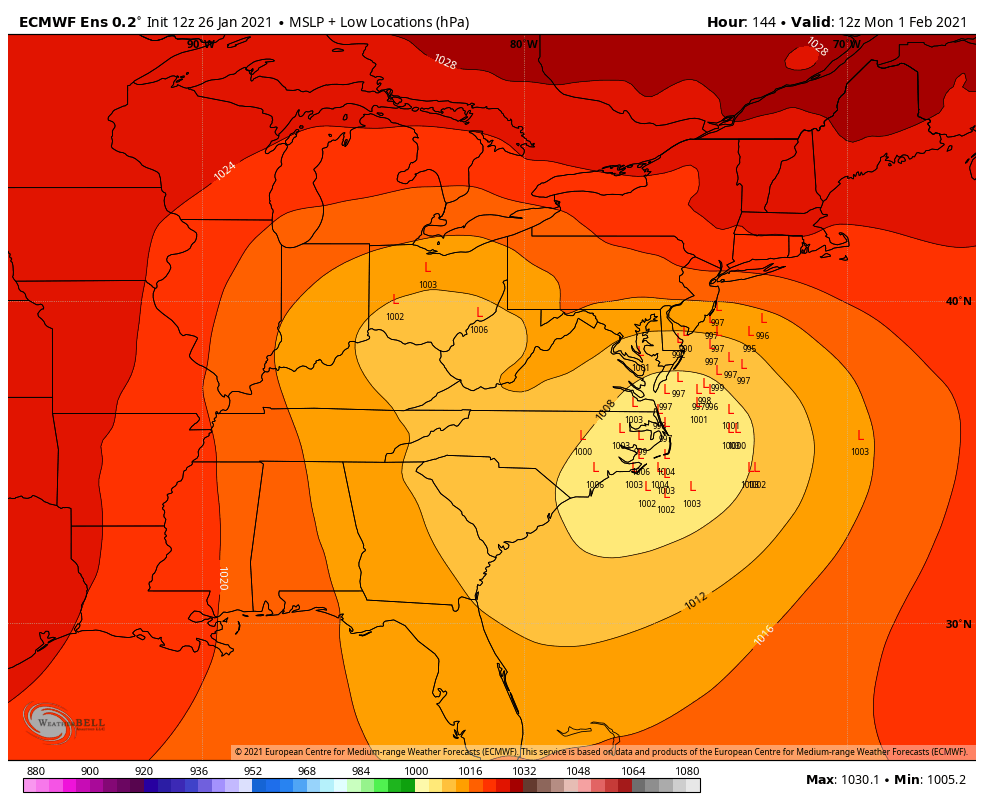
Cobalt replied to WxUSAF's topic in Mid Atlantic
Is that.. son of TPV 1 up in Maine?? This is giving me deja vu because I could've sworn that the Canadian was the first to pick up on this feature for the Thurs event
-
January Storm Term Threat Discussions (Day 3 - Day 7)
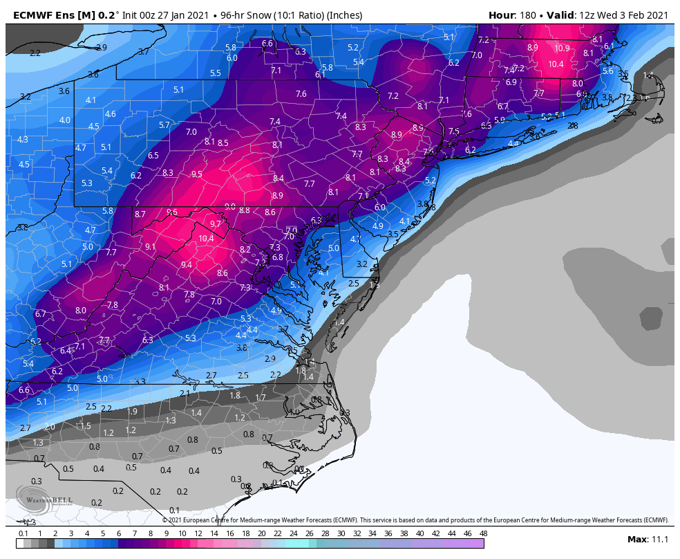
Cobalt replied to WxUSAF's topic in Mid Atlantic
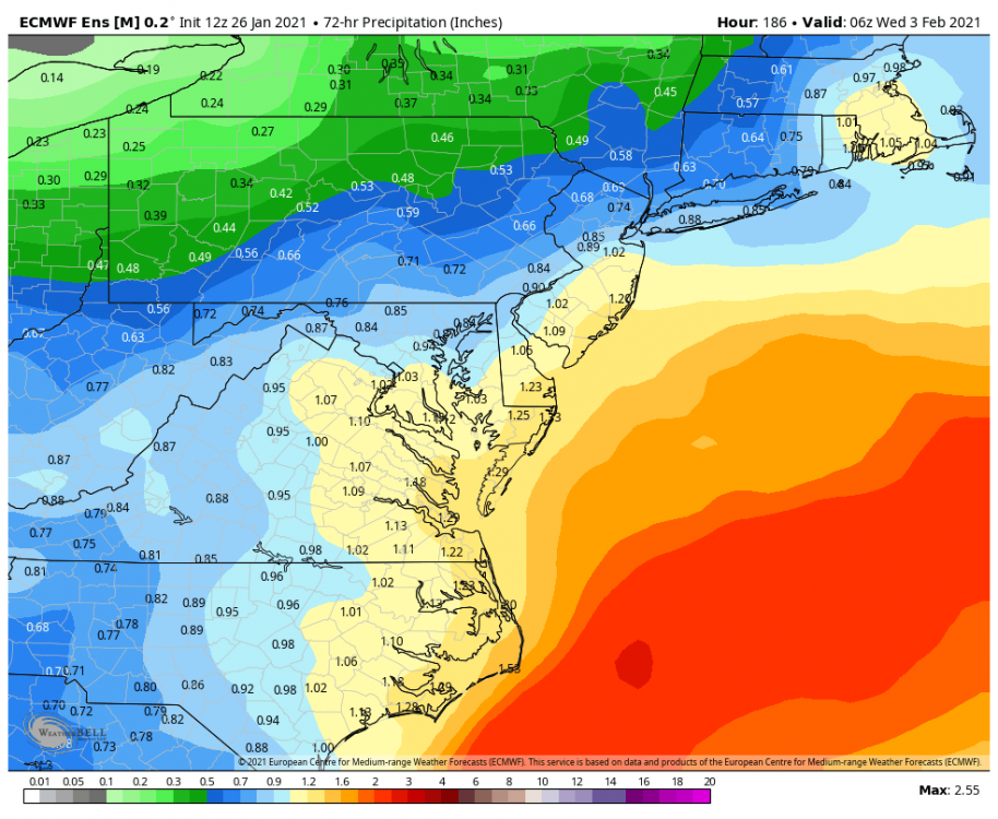
I think.. it's still going after 180? Precip panels not showing up for that timeframe but it appears so. Absolute eye candy, but at least it's not on a complete island... edit: yeah it keeps us snowing through 180 and maybe beyond lol -
January Storm Term Threat Discussions (Day 3 - Day 7)
Cobalt replied to WxUSAF's topic in Mid Atlantic
The low just... meanders. The fact that this GIF takes up like 5% of my attachment space shows that yeah it's pretty lengthy lol
.png.c83d14009c6e455f7ab1042c276c4947.png)


.png.df6833cca54ac3b7e3924c5a4ad3c32c.png)