Cobalt
-
Posts
5,203 -
Joined
-
Last visited
Content Type
Profiles
Blogs
Forums
American Weather
Media Demo
Store
Gallery
Everything posted by Cobalt
-

-
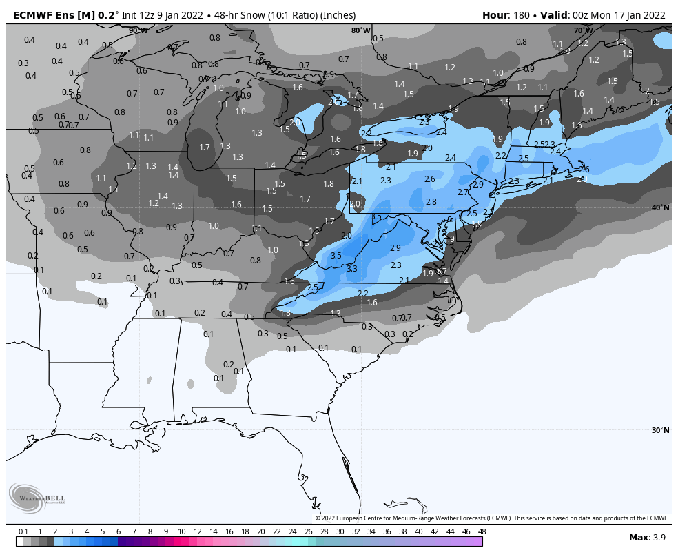
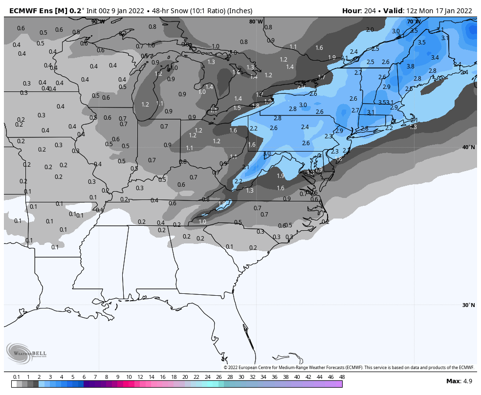
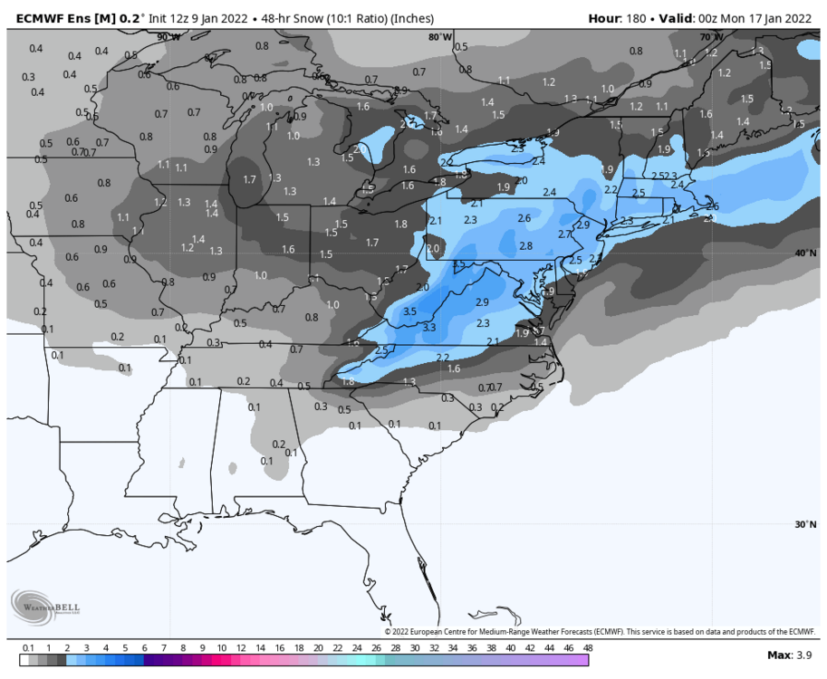
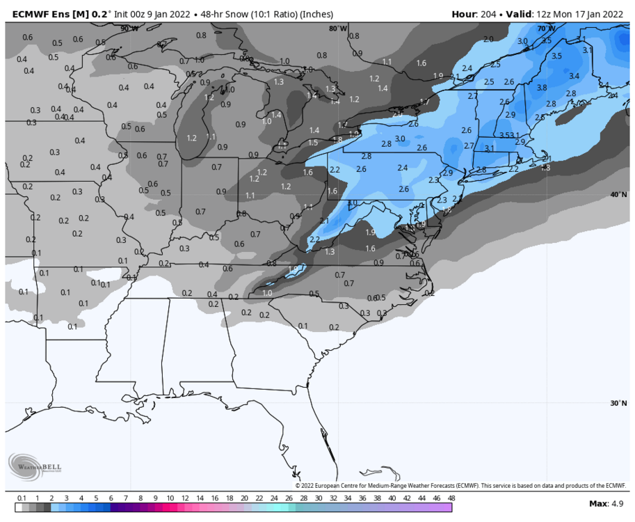
I've done LP comparisons with the OP and Ensembles in the past, but I think it has more weight at this range compared to within 100hrs. There seems to be two camps with the 0z EPS: closer to the coast, and suppressed solutions. The Euro falls in camp two, with this overlay of the OP and Ensemble showcasing that There's a lot of visual clutter here, but the large L represents the Operational run, put on top of the ensemble. It shows a 2 LP look but the most northeast one seems to be the correct position as this panel is mid transfer. This shows that the Euro op run is in the "suppressed" camp for sure. Here's the EPS run itself to clear up any confusion with respect to the OP This is actually a slight improvement from 12z. The spread is to be expected, but the mean is still showing a significant LP somewhere in the vicinity of offshore NC Finally, the look over top improved somewhat compared to 12z. The 50/50 signal shifted a tiny bit west, and the HP position and strength looks as solid as the EPS has shown so far
.thumb.png.c31b370c6a10928d5498b131809ac3d4.png)
.thumb.png.7aae2e53c7ce80d483440dad4b1a8849.png)
-
Canadian Ensembles build a signal for a favorable LP as well
-
The overall snow mean for that timeframe clearly highlights the window that we've been given
-
Pretty nice looking LP cluster this far out
-
Snow mean responds pretty positively to this, with some big hits mixed in. I was trying to find if there was any relation between the offshore D5 system and encouraging a more favorable track for our threat (in the circumstance where that D5 storm strengthened while also approaching 50/50 domain and acting as pseudo 50/50 low), but it's hard to view both LPs using the individual member WxBell maps so I gave up on that.
-
Pretty nice LP mean this far out. Would be more favorable if there wasn't a cluster suggesting the primary takes a route through northern IL, but there's also a (smaller) cluster suggesting the primary tracks through Kentucky. More to be desired but bears watching
-
Some rudimentary research, but here's what I could figure out. 2009-01-21 Tail end of a brutal cold pattern for most of the central and eastern US. 1-28 featured a snow to ice/rain event but the major storm (12-18"+) was confined to the interior NE. 2003-01-15 Southern slider with light accum for DC. 4-10" for SE Virginia. 1980-01-24 Couldn't find much other than a WSW event for North Carolina on the 30th. 1978-01-29 Follows a sizeable MA/NE storm on the 20th and predates the New England blizzard during Feb 5-7th (which we got scraps from). 1961-01-25 Follows a decent storm from the 18th-21st and predates a sizeable one from Feb 2nd-5th. DCA had a high of 18 and a low of 8 on the 25th, so a pretty frigid timeframe. 2004-01-20 Predates a pretty decent system on the 26th. Pretty broad range of 4"+ for most of the subforum. 2007-01-28 Couldn't find much until well after 2003-01-20 Same as previous analog 1996-01-03 Lol I wonder what happened here 2009-12-31 Not much other than a weak system on NYE Biggest takeaway for me is that just about all of these analogs occurred before a substantial system, even if that storm didn't target our general area. A lot were also coupled with brutal temperatures, so if there's any way to test if we can still get "true" cold, this would be the time.
-

Mid-Atlantic winter 2021-22 snowfall contest
Cobalt replied to AnEndlessMaze's topic in Mid Atlantic
#Nailedit -
3.8" here as the final. 2.0" -> 3.6" in just an hour, that band did some serious work. Existing snowpack was replenished and then some. Awesome week of winter weather! Hoping that it's just the beginning
-
2.3” with the band finally here. Insane fluff factor at the moment, easily SN+. .
-
0.9” as of 1:30, with nearly all of that falling in an hour. Hoping to push 2” before this thing scoots out of here .
-
Did Beans, Bill, and Ball enjoy the snow last Monday?
-
Enjoy it for another hour and a half
-
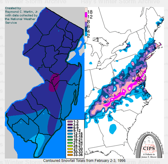
I mentioned that the axis of snow felt reminiscent of a random snowstorm accum map I saw from 95-96, and I just now found the match. Hmmmm The northern cutoff is drastically different but ofc you can't have it all
-
-
Not sure about DC, but I recorded 1.6" on 1/17/19, 4 days after DCA recorded a double digit snowfall. I could probably find the total, but that seems like the last time. A lot of our recent futility stems back to the period after the 18-19 winter.
-
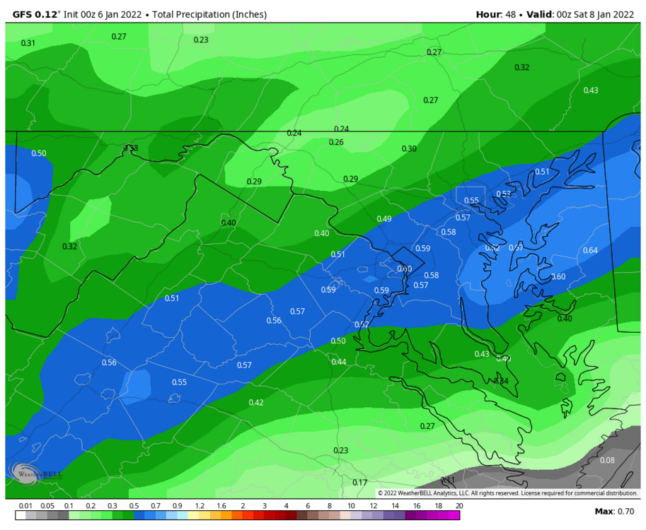
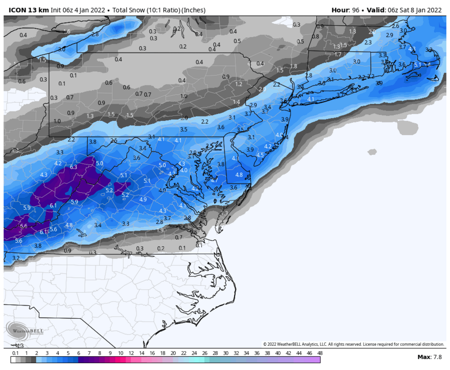
ICON likes snow for Friday
-
Mid-Atlantic forum winter 2021/22 snow totals thread
Cobalt replied to North Balti Zen's topic in Mid Atlantic
1/3 - 6.5". Fast moving snow bomb. 5" in 4 hours, areas to SE eclipsed double digits. 1/7 - 3.8". Speedy redeveloper w/ a miracle snowband, 1.6" in just one hour. 1/16 - 2.6". Frigid powder turns to sleet/rain with wicked winds. 1/29 - 0.8"*. Season Total: 13.7" * = Based on spotter reports -
6.5" final. Biggest La Nina snowfall since Jan 26 2011 (8.1"). 5" fell from 8am-12, including 2"/hr rates for part of that duration. Great storm, can't wait for the deep winter conditions tonight and tomorrow morning. Oh btw, I completely forgot to change my location back to McLean due to winter break. Apologies
-
5.8” as of 11am. Firmly into WSW criteria. The back end is close, but that band pivoting through DC looks like it might give us some action. Glad to hear that the SE peeps cashed in, great event for you guys!! .
-
3.6” now, so 0.8” in the last 30 minutes. Keeps getting heavier too. .
-
2.8” in McLean as of 9am. Would not be surprised to be exceeding 4” within the hour, heavy snow with yellows on the doorstep. 1.3” from 8 to 9. .
-
lol i'm sure they have. Thank you for making snow measuring a competitive sport!

.png.3b09d3e00365bb390309a637491290e9.png)
.png.60e52061afe3b2a0e38001812919b23e.png)