Cobalt
-
Posts
4,908 -
Joined
-
Last visited
Content Type
Profiles
Blogs
Forums
American Weather
Media Demo
Store
Gallery
Everything posted by Cobalt
-

Feb 12/13 Event Quest for Blues to Envelop More Rather Than Less
Cobalt replied to North Balti Zen's topic in Mid Atlantic
-
Feb 12/13 Event Quest for Blues to Envelop More Rather Than Less
Cobalt replied to North Balti Zen's topic in Mid Atlantic
57/33 in McLean. It's nice to have a snow event line up with the one weekend I'm home. Hoping for 1.3", that'll put my location over 15" for the year (the average in a data set of 11 winters here is 16.9", but that doesn't include 09/10). Should be close! -
Feb 12/13 Event Quest for Blues to Envelop More Rather Than Less
Cobalt replied to North Balti Zen's topic in Mid Atlantic
It's time to revive March 25th snows and make them the new December 5th. -
Feb 12/13 Event Quest for Blues to Envelop More Rather Than Less
Cobalt replied to North Balti Zen's topic in Mid Atlantic
I would be perfectly okay with getting 3" of SB Sunday snow to watch fall at home compared to watching 7" of snow fall at college. Too bad it's the NAM -
The Australian model disagrees, looks like it's saying that it's 4 months away
-
How ya feelin about next winter?
-
I mean.. we did have that one wet paste storm this time last year. Was impressive for some areas but ofc for most what little snow fell melted by midday.
-
If it makes you feel any better, it looks like the Canadian fringes you in an opposite direction by vaulting the initial precip well NW https://collaboration.cmc.ec.gc.ca/cmc/cmdn/pcpn_type/pcpn_type_gem_reg.html
-
-
story of your post quality too
-
Very light snow in Harrisonburg while walking to class. Nice ambience
-
Moderate rain showers, actually.
-
Trough goes negative a bit too late for us but still a pretty decent hit. Pretty interesting h5 setup
-
And even then.. it lined up with a pretty significant snow event for the central/southern parts of our subforum. The Jan 3rd event was -AO/-NAO, and all it took was the PAC puke to relax a bit for that event to be possible.
-
Timing certainly can't hurt at least.. would be somewhat uncharacteristic to go this far into the winter without an elevation dependent forum divider, but that's just my hunch.
-
One thing I'm looking out for is if the Atlantic becomes more favorable late into Feb. Past Ninas had that as a turning point, recently with March 2017 and 2018. Those didn't take a favorable PAC state to produce good snowfall in parts of the subforum.
-
Hold on, we got conflicting information here I believe Staten Island Chuck's protocol is different. Must've seen 6 more weeks of -PNA...
-
Re: @clskinsfanin the closed Med Range thread saying "I liked the long range look from a couple of days ago a little better with higher heights poking into Greenland" The 12z GEFS might strike your fancy. It's been showing up a lot at this range on the OP runs, so it's nice to see the ensembles hinting at it too.
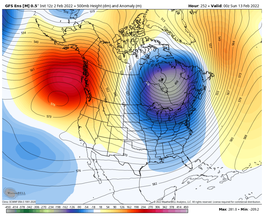
-
Late January and February Medium/Long Range Discussion
Cobalt replied to WinterWxLuvr's topic in Mid Atlantic
Pretty ugly looking CAD signal showing up for that too.- 4,130 replies
-
- 3
-

-
- prime climo
- cold canada
- (and 1 more)
-
Late January and February Medium/Long Range Discussion
Cobalt replied to WinterWxLuvr's topic in Mid Atlantic
Not sure I follow. The only Januaries I can see topping it are Jan 2016, Jan 2014, and maybe Jan 2011? That's still an above average month, if not top 4 or 3. It feels like we've lost our bread and butter Januaries as of late. They've either produced prolonged unproductive periods or plain old thaws. After our last 60 degree day this one was off to the races. I prepped up my own snow drought thread in anticipation for this year to be yet another entry in the list, but so far it's proven that it isn't a typical -PDO La Nina. If we don't get our February torch.. then that's yet another theme this winter goes against. -
Late January and February Medium/Long Range Discussion
Cobalt replied to WinterWxLuvr's topic in Mid Atlantic
11", all from January alone? That may very well be your 2nd or 3rd best January in the past decade. We still have ~60 days left where it can snow, so take a bit of a breather. In a land of sucky winters, a slightly below average winter is king. I think that's how the saying goes?- 4,130 replies
-
- 2
-
-
- prime climo
- cold canada
- (and 1 more)
-
Late January and February Medium/Long Range Discussion
Cobalt replied to WinterWxLuvr's topic in Mid Atlantic
Looks like 129 is the changeover panel, 850s are below freezing for points near and slightly SE of DC then. Surface temps in the mid 20s.- 4,130 replies
-
- 2
-
-
- prime climo
- cold canada
- (and 1 more)
-
January 28-29 2022 Miller abcdefu Storm Obs/Discussion
Cobalt replied to mappy's topic in Mid Atlantic
Sidewalks beginning to cave, 30 degrees with moderate snow atm -
January 28-29 2022 Miller abcdefu Storm Obs/Discussion
Cobalt replied to mappy's topic in Mid Atlantic
Light snow in Harrisonburg. There's still decent snowpack from the event two weeks ago, which is pretty impressive. -
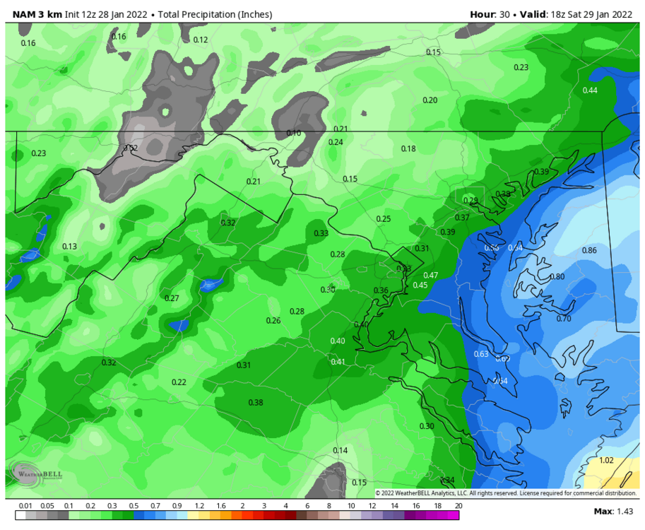
January 28-29 2022 Miller abcdefu Storm Obs/Discussion
Cobalt replied to mappy's topic in Mid Atlantic
3k NAM