DownpourDave
-
Posts
1,353 -
Joined
-
Last visited
Content Type
Profiles
Blogs
Forums
American Weather
Media Demo
Store
Gallery
Everything posted by DownpourDave
-
The Congrats Dendrite Deck Destroyer 3/23-3/25 obs discussion
DownpourDave replied to Ginx snewx's topic in New England
Gauge at Plymouth Campus Up to 1.72 inches.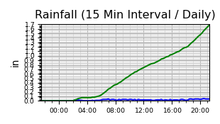
-
The Congrats Dendrite Deck Destroyer 3/23-3/25 obs discussion
DownpourDave replied to Ginx snewx's topic in New England
May make a run at 20”. Let’s see what the final 2 hours of this has in store. 17” right now.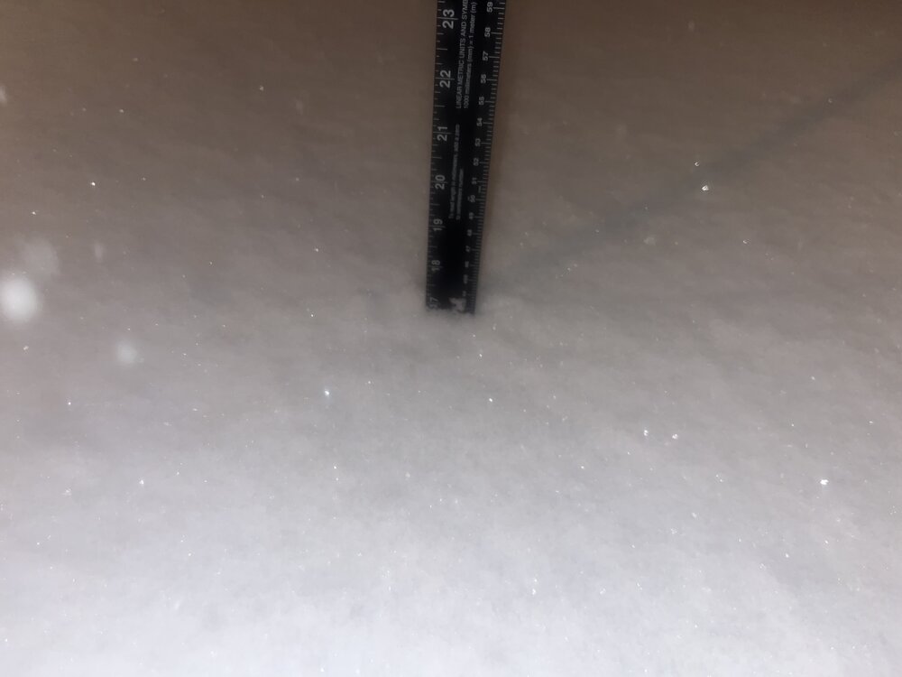
-
The Congrats Dendrite Deck Destroyer 3/23-3/25 obs discussion
DownpourDave replied to Ginx snewx's topic in New England
Just measured, up to 15.5” inches of snow. Liquid up to around 1.4 inches so roughly 10:1 ratios. -
The Congrats Dendrite Deck Destroyer 3/23-3/25 obs discussion
DownpourDave replied to Ginx snewx's topic in New England
Just measured, roughly 13 inches here. Rough estimate, snowboard not used. -
The Congrats Dendrite Deck Destroyer 3/23-3/25 obs discussion
DownpourDave replied to Ginx snewx's topic in New England
Sleet briefly mixed in, back to all snow. -
The Congrats Dendrite Deck Destroyer 3/23-3/25 obs discussion
DownpourDave replied to Ginx snewx's topic in New England
The signs were there…. Still wait and see but looks like the NAM was wrong.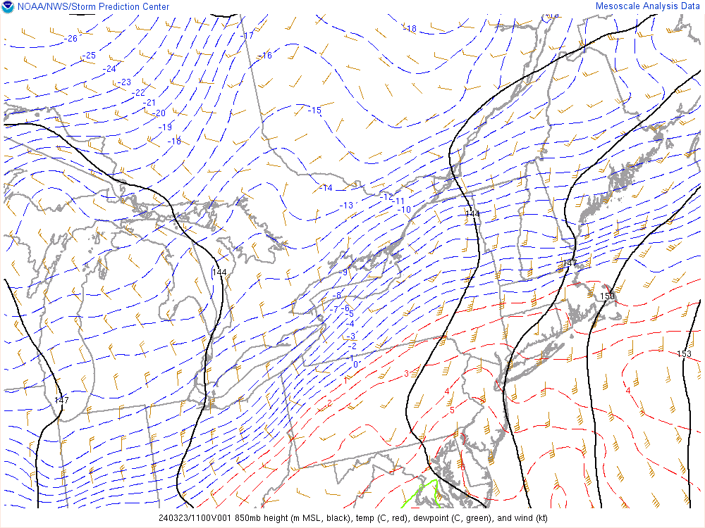

-
The Congrats Dendrite Deck Destroyer 3/23-3/25 obs discussion
DownpourDave replied to Ginx snewx's topic in New England
This is the farthest north I believe the mix line will get.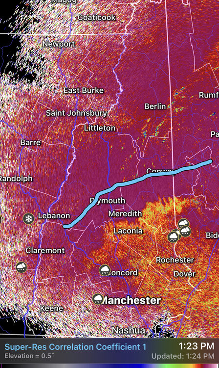
-
The Congrats Dendrite Deck Destroyer 3/23-3/25 obs discussion
DownpourDave replied to Ginx snewx's topic in New England
Thanks for the observations. I am estimating I have another 1 hour or 2. -
The Congrats Dendrite Deck Destroyer 3/23-3/25 obs discussion
DownpourDave replied to Ginx snewx's topic in New England
I could care less if the mix line gets up to me, I am just hoping Cannon stays all snow. -
The Congrats Dendrite Deck Destroyer 3/23-3/25 obs discussion
DownpourDave replied to Ginx snewx's topic in New England
Latest metar for MHT METAR KMHT 231153Z COR 05004KT 1SM R35/P6000FT -SN BR FEW008 OVC021 M01/M03 A3018 RMK AO2 SFC VIS 1 1/4 SLP237 P0009 60038 70038 T10111033 11006 21011 58004 -
The Congrats Dendrite Deck Destroyer 3/23-3/25 obs discussion
DownpourDave replied to Ginx snewx's topic in New England
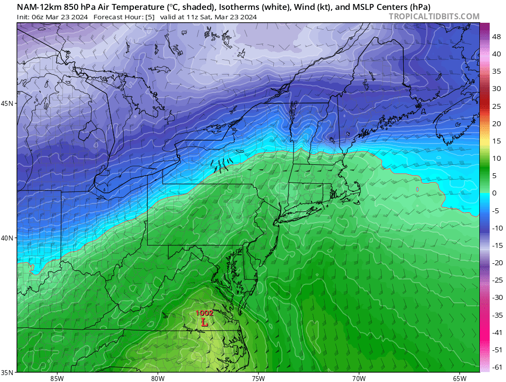
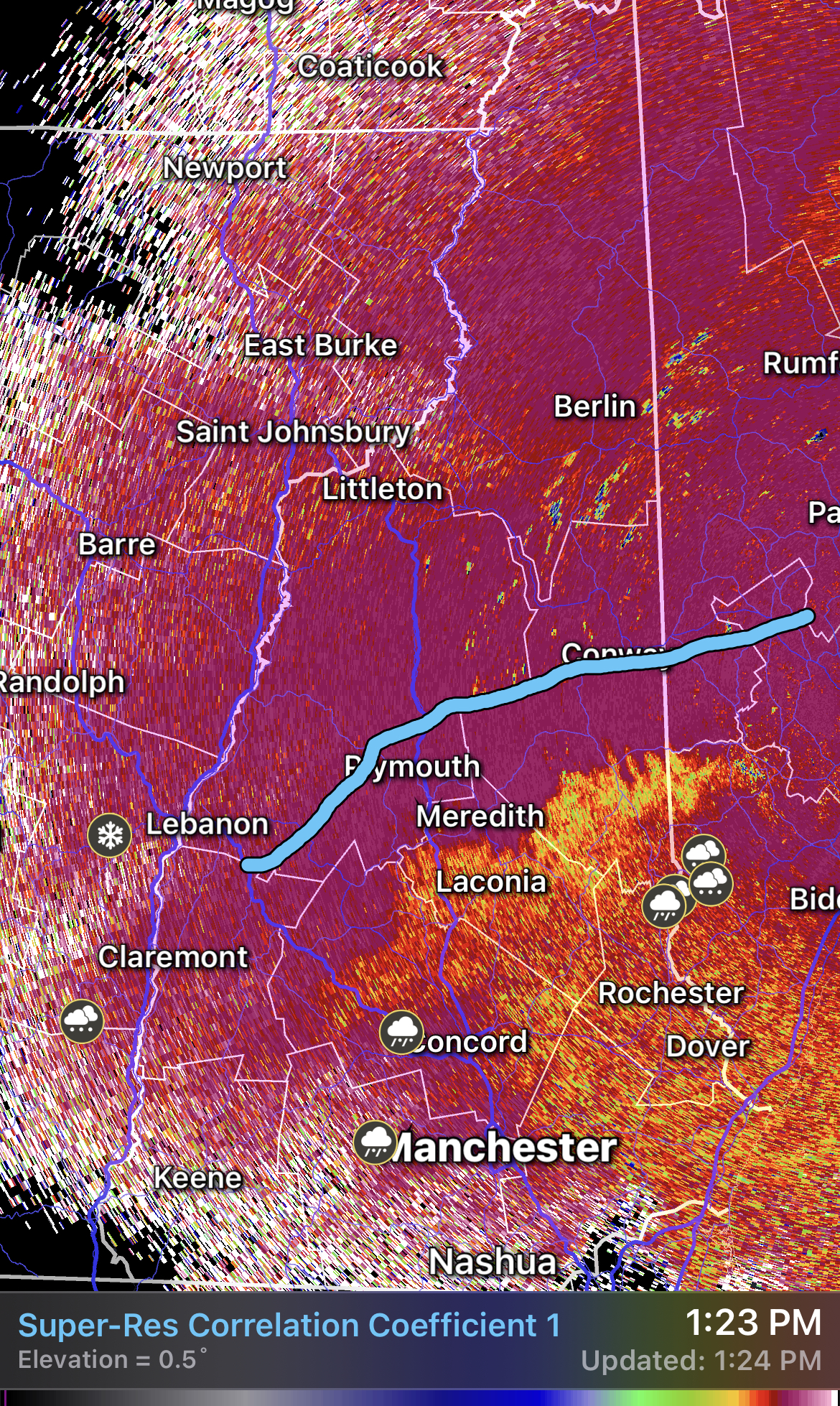
I honestly couldn’t find the warm layer. 850s and 925 below freezing from where radar says the sleet line is. Using cc as the sleet line, NAM is a touch too far north and HRRR is a touch too far south. -
The Congrats Dendrite Deck Destroyer 3/23-3/25 obs discussion
DownpourDave replied to Ginx snewx's topic in New England
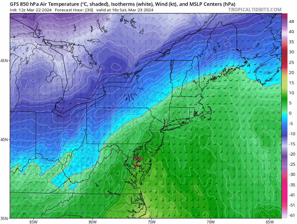
Do you think the NAM is right with the mid level warm surge. Now casting says the depiction is full of shit. Current 850s NAM 850s
-
The Congrats Dendrite Deck Destroyer 3/23-3/25 obs discussion
DownpourDave replied to Ginx snewx's topic in New England
No it is not. At least 850 temperatures.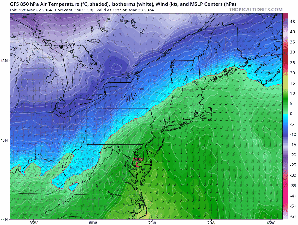
-
The Congrats Dendrite Deck Destroyer 3/23-3/25 obs discussion
DownpourDave replied to Ginx snewx's topic in New England
I personally think 8-12 is a good guess along with a wintery mix with maybe a flip back to snow at the end. If it verified a little colder aloft, those higher totals that the models are spitting are very well might verify. -
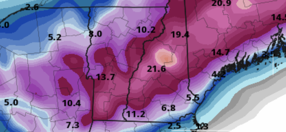
RGEM shows a Waterville Valley Jackpot. I might decide to ski Cannon on Sunday.
-
Lourdes did not leave, she was promoted to Provost. If you want I can say “someone from x class year” says hello if you’re not comfortable giving your name but are comfortable sharing what class year you were. Do you know Scott Reynolds who works at the CWSU in Nashua, NH? He teaches at Plymouth. I mention him because he’s one of my favorite professors there, him along with Dr. Sam Miller.
-
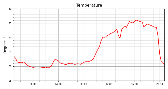
Can anyone guess when the precip started?
-
Anything specific I should say so that they know who the “hello” is from? I am guessing you were before Prof. Eric Kelsey’s time.
-
Pasty 1-2 inches here near Plymouth. Can confirm 93 is not great.
-
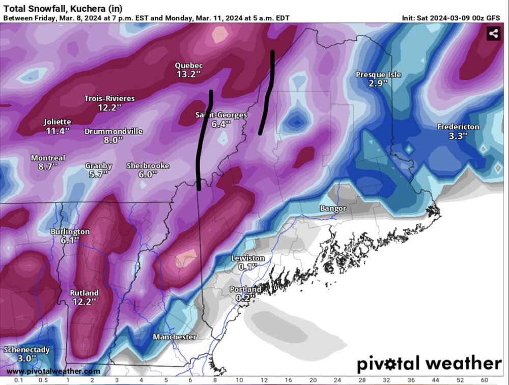
Most of the snow will be occurring at night so that will help with accumulations. This is probably a more realistic map.
-
Respectfully, you are wrong. CAD has a tendency of being under estimated by the models.
-
Surprised no one mentioned that the whites look to do well this weekend. CAD setup suggested by many of the models. You might even get some snow dendrite this weekend. At the very least the ski resorts like Waterville Valley and Cannon will replenish some of what they lost. Thermal profiles suggests the snow will be of the heavy wet variety so definitely will not be skiing on powder on Monday.
-
@NorthArlington101 pm please not sure if you got a notification for it
-
What Went Wrong in Winter 23-24/Base State/Will It Ever Snow Again??
DownpourDave replied to WxUSAF's topic in Mid Atlantic
Also, The historic 09-10 winter, 2016 one storm wonder, and the winters you mentioned all had neutral to positive PDO at times. That is one of the main differences between 09-10 and now (the PDO). We do not actually know if that historic winter would have worked with a strongly negative PDO. @psuhoffman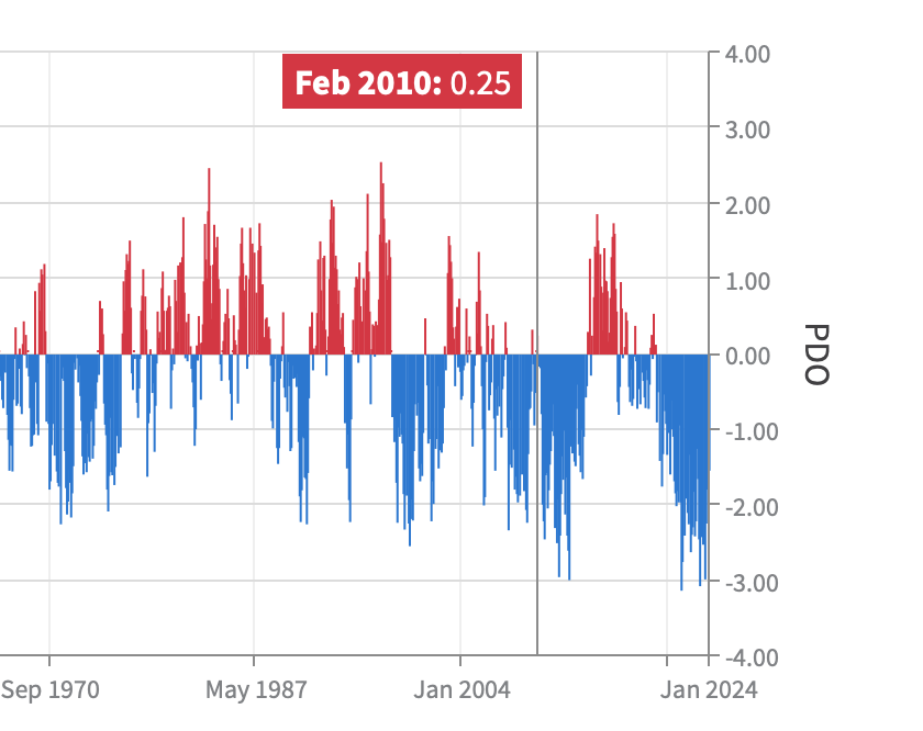
-
What Went Wrong in Winter 23-24/Base State/Will It Ever Snow Again??
DownpourDave replied to WxUSAF's topic in Mid Atlantic
in the grand scheme of things, 2016 was not that long ago. Have we warmed that much since 2016/reached a tipping point? Maybe the Tonga eruption was a factor in having us go past the tipping point?