DownpourDave
-
Posts
1,353 -
Joined
-
Last visited
Content Type
Profiles
Blogs
Forums
American Weather
Media Demo
Store
Gallery
Everything posted by DownpourDave
-
Upstate/Eastern New York
DownpourDave replied to BuffaloWeather's topic in Upstate New York/Pennsylvania
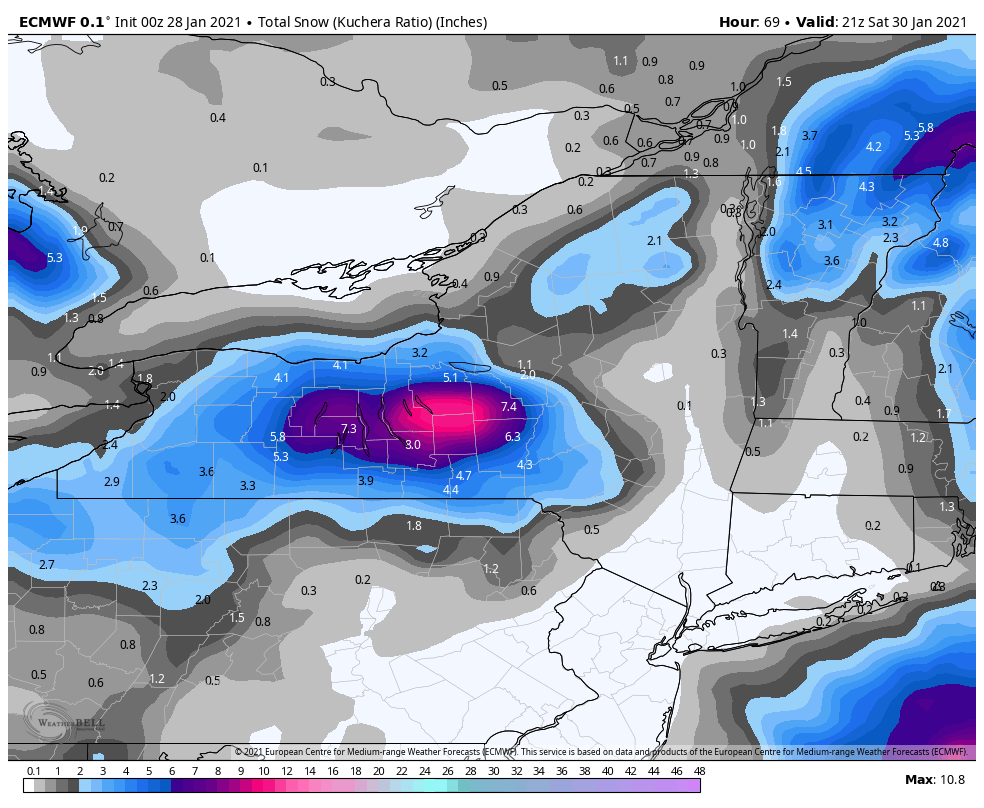
lol if Ontario county actually gets .2 precipitation *30 ratios = 6 inches of snow easy. -
Upstate/Eastern New York
DownpourDave replied to BuffaloWeather's topic in Upstate New York/Pennsylvania
remember when it was said Geneva does not get much lake effect snow. This particular run is interesting in that regard lol. 7 inches of LES.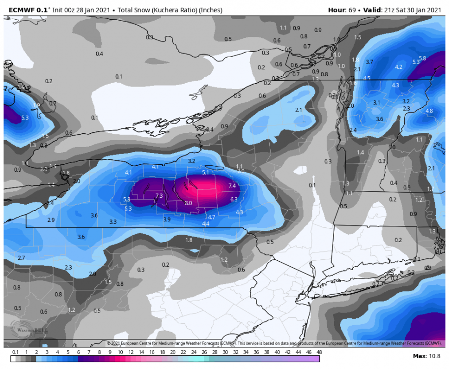
-
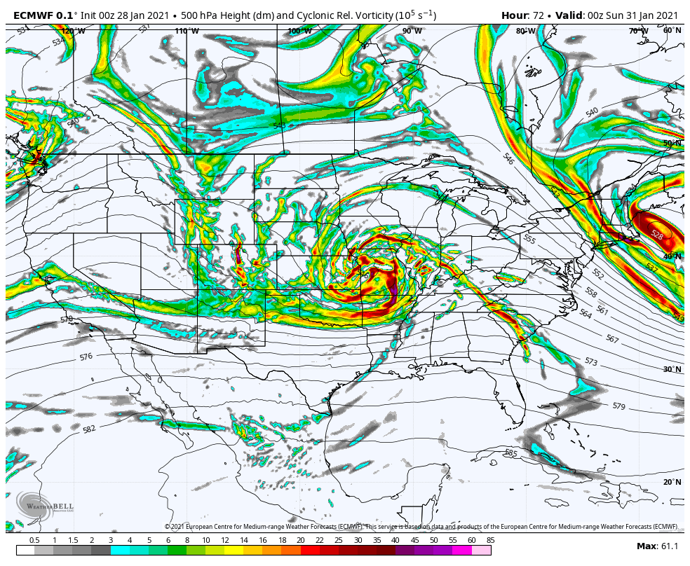
northern stream is quicker this run, this run should result in a complete phase.
-
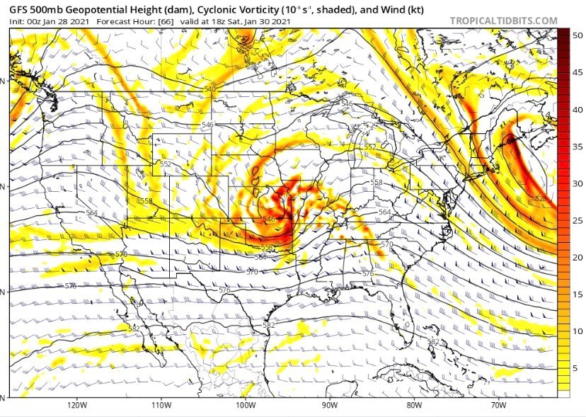
Closed upper-level low over Missouri at hour 72. Confluence has backed off a bit more vs 12z.

-
Upstate/Eastern New York
DownpourDave replied to BuffaloWeather's topic in Upstate New York/Pennsylvania
I would guess 3-4 inches currently in protected areas. 1-2 inches in exposed areas. -
Upstate/Eastern New York
DownpourDave replied to BuffaloWeather's topic in Upstate New York/Pennsylvania
yeah when we do get lake effect it is generally 1-3 while other places are getting blasted with 3 feet + -
Upstate/Eastern New York
DownpourDave replied to BuffaloWeather's topic in Upstate New York/Pennsylvania
I got it. So the CCB would be nice obviously but places Syracuse and west really should not count on it. We need to root for good snow from the WAA. -
Upstate/Eastern New York
DownpourDave replied to BuffaloWeather's topic in Upstate New York/Pennsylvania
Yes that run. The 00z gfs. -
Upstate/Eastern New York
DownpourDave replied to BuffaloWeather's topic in Upstate New York/Pennsylvania
what is your opinion about the gfs? How often do you see the finger lakes region get CCB action. Seems like it would not be very common. -
Upstate/Eastern New York
DownpourDave replied to BuffaloWeather's topic in Upstate New York/Pennsylvania
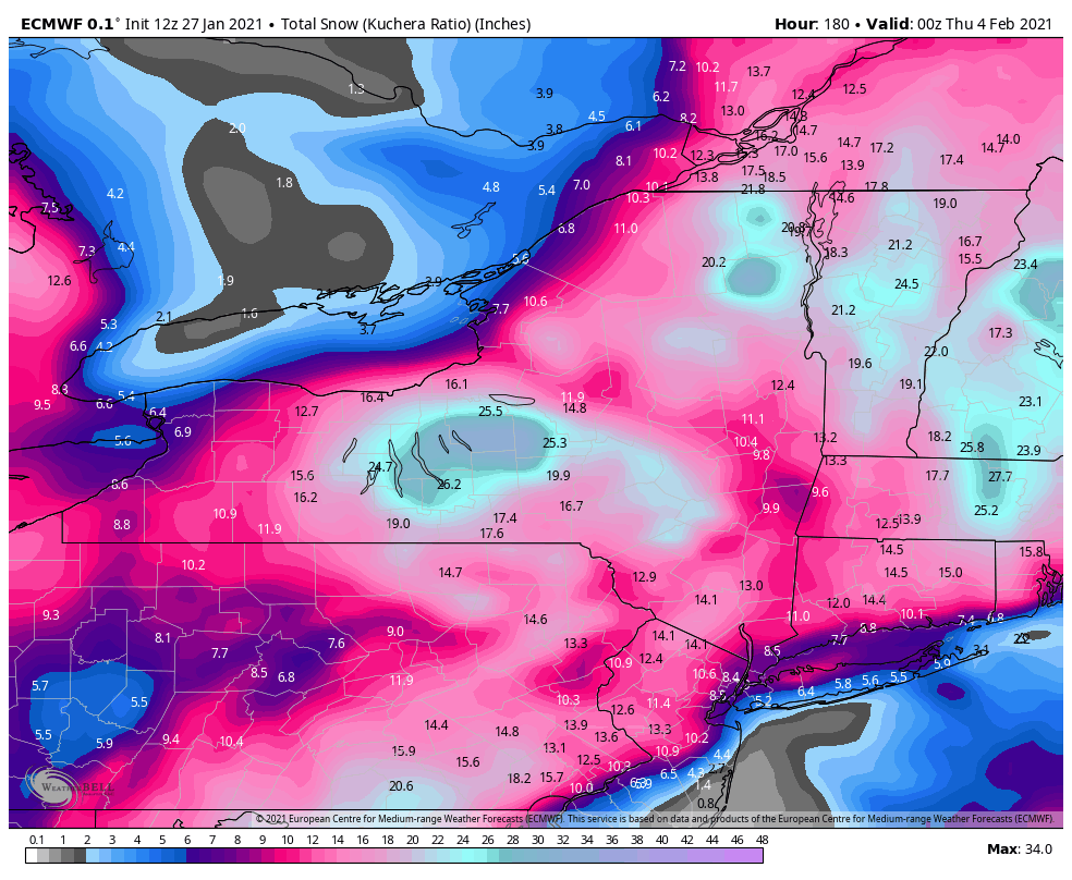
it is gorgeous. CCB pivots right over us. 24 hour + snowstorm with ratios in that CCB probably pushing 18:1 + -
Closes off over Kansas
-
Upstate/Eastern New York
DownpourDave replied to BuffaloWeather's topic in Upstate New York/Pennsylvania
even so it has been consistent. Maybe it will fall on its sword. -
Upstate/Eastern New York
DownpourDave replied to BuffaloWeather's topic in Upstate New York/Pennsylvania
Icon once again is a great run for us. Man I would love it to be correct. How good is the model.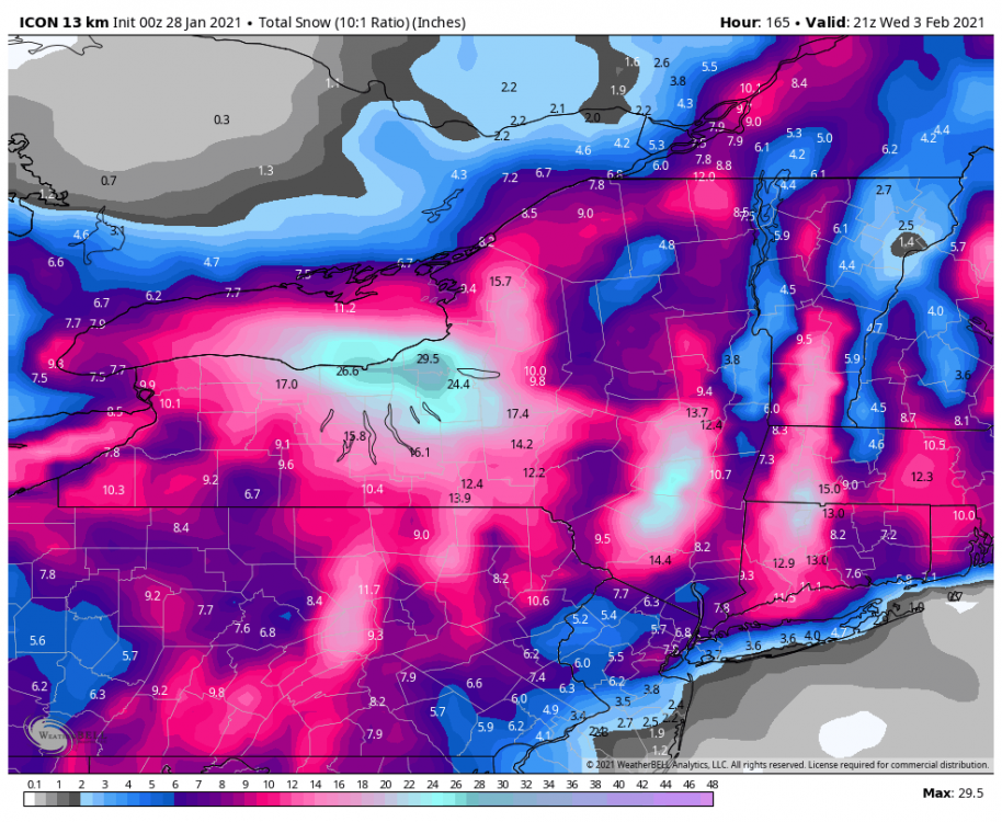
-
this is just silly
-
Upstate/Eastern New York
DownpourDave replied to BuffaloWeather's topic in Upstate New York/Pennsylvania
euro verbatim is cold smoke! 18:1 ratios it seems like.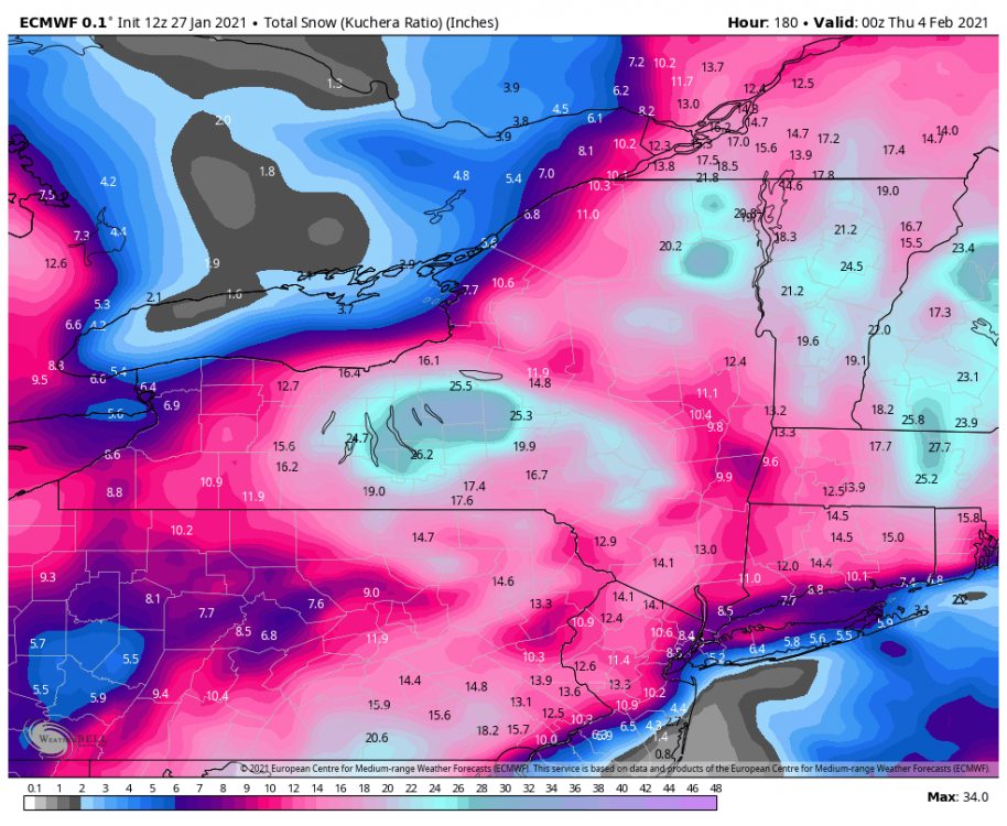
-
January Storm Term Threat Discussions (Day 3 - Day 7)
DownpourDave replied to WxUSAF's topic in Mid Atlantic
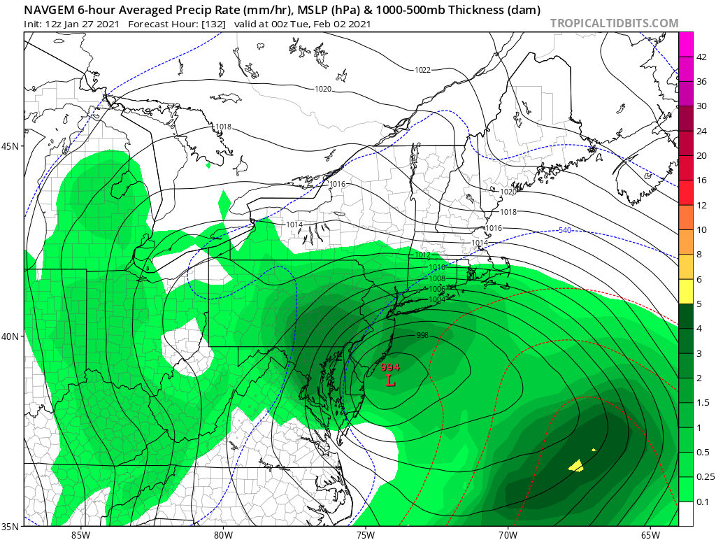
euro actually looks very similar to NAVGEM -
January Storm Term Threat Discussions (Day 3 - Day 7)
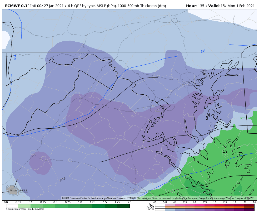
DownpourDave replied to WxUSAF's topic in Mid Atlantic
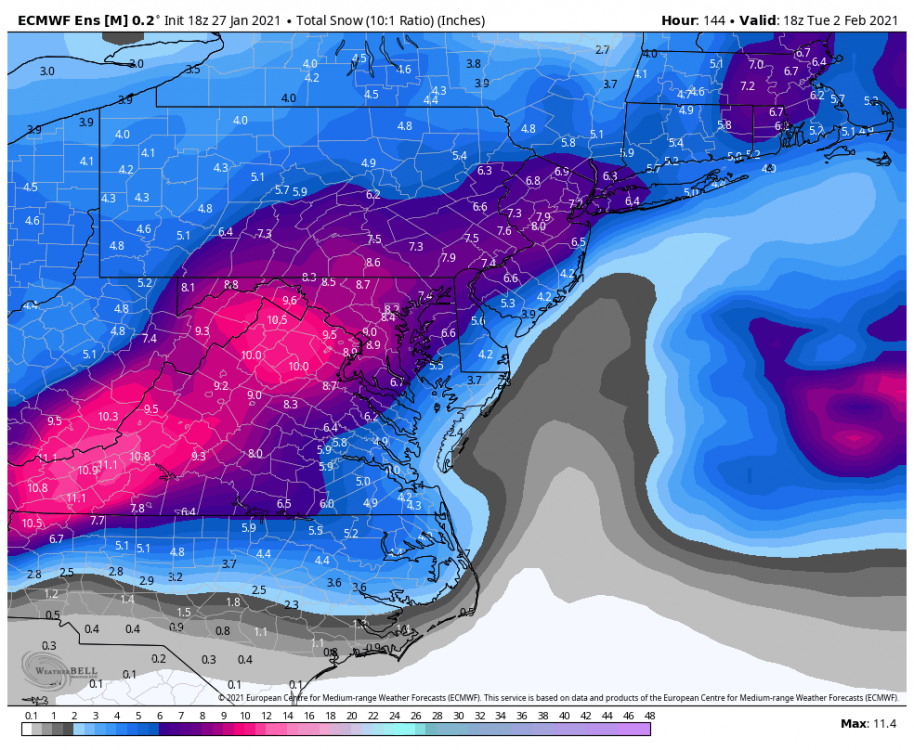
EURO destroys DC with the CCB starting at hour 111 -
January Storm Term Threat Discussions (Day 3 - Day 7)
DownpourDave replied to WxUSAF's topic in Mid Atlantic
maybe the NAVGEM finally gets one right. It obliterates the sub-forum with the CCB.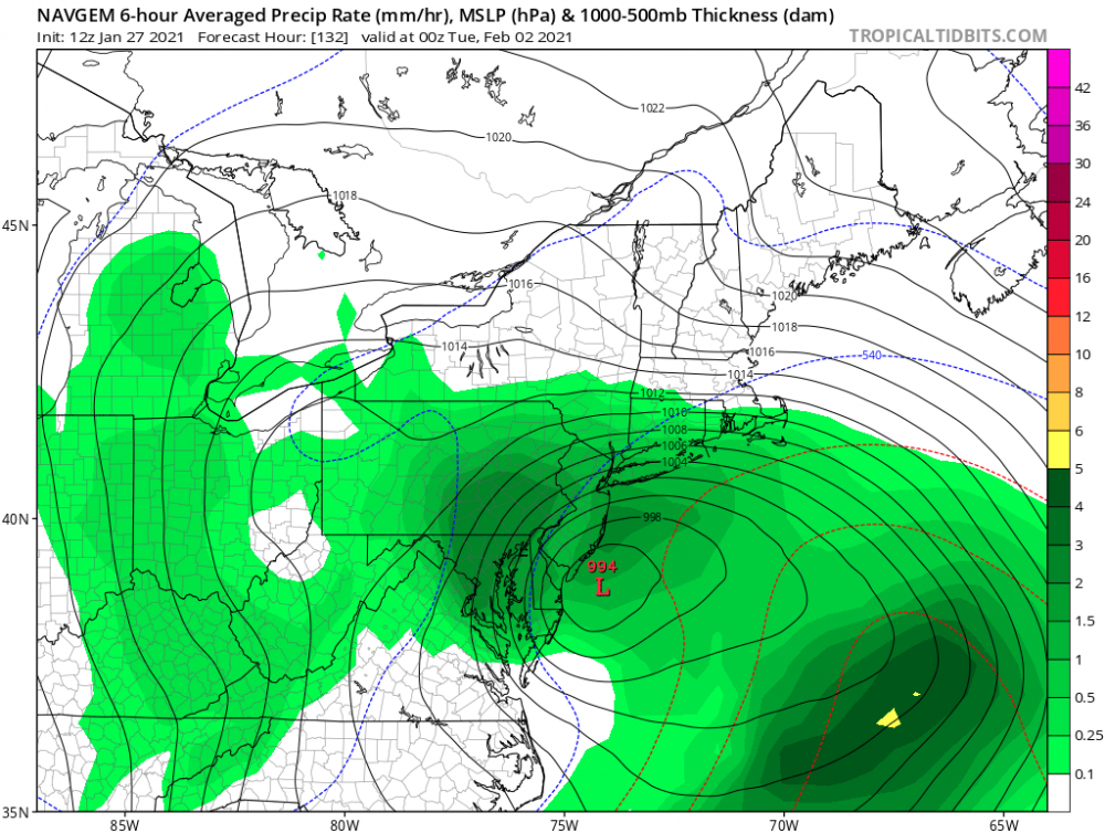
-
Upstate/Eastern New York
DownpourDave replied to BuffaloWeather's topic in Upstate New York/Pennsylvania
Icon is iconic. 2' to 3' of snow -
January Storm Term Threat Discussions (Day 3 - Day 7)
DownpourDave replied to WxUSAF's topic in Mid Atlantic

-
January Storm Term Threat Discussions (Day 3 - Day 7)
DownpourDave replied to WxUSAF's topic in Mid Atlantic
through 84 hours it is clear euro will come north of 12z run. Better ridging in middle of the country. -
January Storm Term Threat Discussions (Day 3 - Day 7)
DownpourDave replied to WxUSAF's topic in Mid Atlantic
through 78 hours, the shortwave is more amplified with the heights out west being a little bit higher. -
January Storm Term Threat Discussions (Day 3 - Day 7)
DownpourDave replied to WxUSAF's topic in Mid Atlantic
The storm just entering the western United States at hour 63. -
January Storm Term Threat Discussions (Day 3 - Day 7)
DownpourDave replied to WxUSAF's topic in Mid Atlantic
through 57, confluence over the NE is better. -
January Storm Term Threat Discussions (Day 3 - Day 7)
DownpourDave replied to WxUSAF's topic in Mid Atlantic
virtually identical to 18z euro through 54