Paleocene
-
Posts
2,053 -
Joined
-
Last visited
Content Type
Profiles
Blogs
Forums
American Weather
Media Demo
Store
Gallery
Everything posted by Paleocene
-

The February 22-23 Late Season Miracle: JV Disco/Banter Thread
Paleocene replied to bncho's topic in Mid Atlantic
Those of you who like gambling need to get in on predictive markets. I saw that writing on the wall yesterday morning that the storm was going to be a nj-boston special. I put down $10, that Boston would see more than 20 in this month, and now I can cash out for $25 before the storm even happens lol. Free money if you obsessively track models... And can tolerate a little bit of risk
-
The February 22-23 Late Season Miracle: JV Disco/Banter Thread
Paleocene replied to bncho's topic in Mid Atlantic
Go to Cape May! Pretty town, not a city, on a peninsula so you'll get destroyed by wind lol. Easy access to garden state parkway which should be priority to clear My bar for my backyard is 4" otg.. including roads... Monday am. We'll see. Not the 36" I was promised LOL -
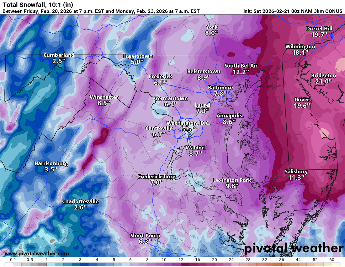
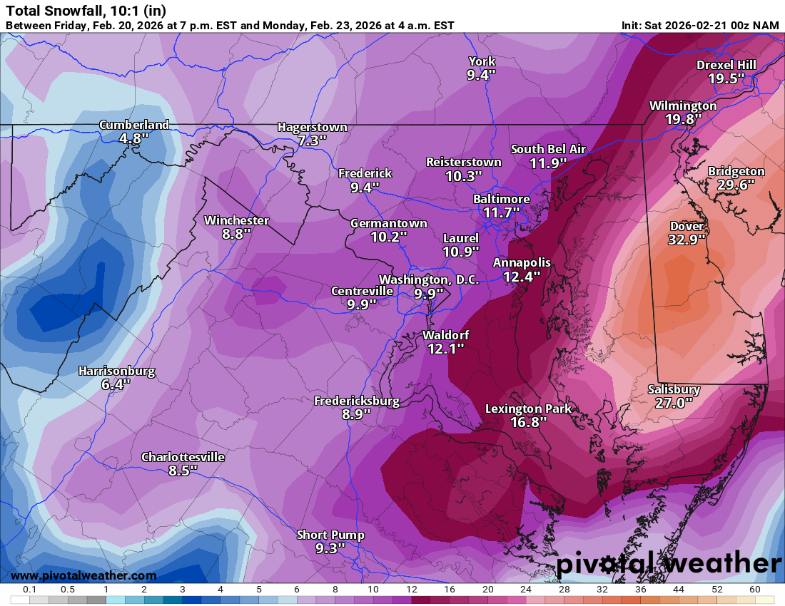
3k. still snowing after hour 60, so not done with totals here.

-
Hmm? Maybe not everywhere on the map (eg where you live), but on many places it does?? 9.9 --> 7.5 for MBY == -25%. Fredericksburg 8.9 --> 5.8 == -33%
-
still a bit more to come for delmarva. snow depth cuts totals in half kuch maybe drops by 25-33%
-
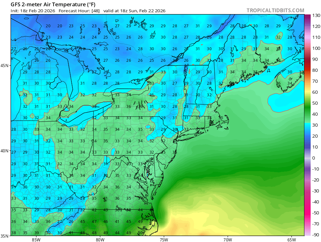
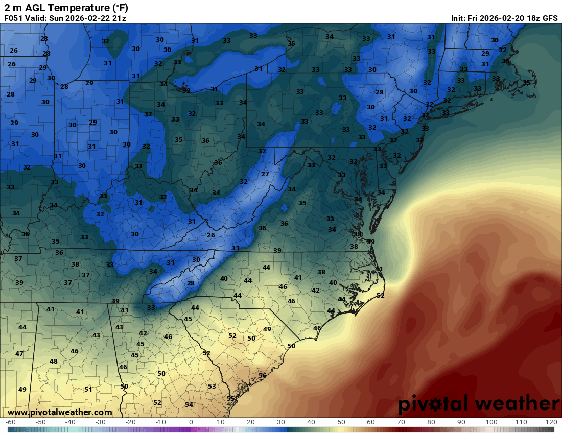
Indeed. Which is why in my hot UHI backyard im gonna be sweating thermals. Maybe the mesos will show better temps and I can stop worrying
-
I'm on that 33 lol. And that's 21z. Worse earlier in day

-
Some spots on the Jersey Shore got nearly 3" on that run. But yeah, no more 4" lollies
-
Worth noting that GFS still has us sweating thermals at the surface. upstairs looks good at all levels. We're gonna be praying for good rates in the cities to overcome the UHI death zones!

-
still a bit more to come for east of the bay after this panel.
-
Agreed and they have time to hoist watches if things trend colder.
-
Feb 22nd/23rd "There's no way..." Storm Thread
Paleocene replied to Maestrobjwa's topic in Mid Atlantic
Someone probably posted this a bit ago, but the GEFS really hasnt backed off the tucked solutions at all. Pretty amazing. Orientation / trajectory / position changed a bit, but I see no caving to the easterly/OTS low solutions that euro suite was spitting out. Caving to the GFS, who'd have thunk it. -
Feb 22nd/23rd "There's no way..." Storm Thread
Paleocene replied to Maestrobjwa's topic in Mid Atlantic
I don't remember 2014, but the 2011 was the 'commuteaggedon' puke/paste job which left people stranded on i-66 and elsewhere for many hours. -
Yep same here. Fun start to the day
-
Dumping rain in silver spring now
-
Feb 22nd/23rd "There's no way..." Storm Thread
Paleocene replied to Maestrobjwa's topic in Mid Atlantic
Lol March 2013. I remember staying home from work that day (I guess we were told to not come in?) and watching it rain/snizzle. Almost as bad as boxing day, but in March, so it hurt less. We were supposed to get like a foot in DC -
Feb 22nd/23rd "There's no way..." Storm Thread
Paleocene replied to Maestrobjwa's topic in Mid Atlantic
Lol I understand the synoptics. I was joking about PSUs 10,099 posts in 39 seconds about the IVT. I'll run away with my tail tucked between my legs now -
Feb 22nd/23rd "There's no way..." Storm Thread
Paleocene replied to Maestrobjwa's topic in Mid Atlantic
and @clskinsfan Indeed. Multiple paths to win here. I was mostly being critical/joking about PSU because I think he knows that he's not gonna get the jack on any coastal (if one happens). He wants the IVT jack in his backyard. The man is always rooting for his jackpot. The Euro also looks *this close* to getting captured... one can dream -
Feb 22nd/23rd "There's no way..." Storm Thread
Paleocene replied to Maestrobjwa's topic in Mid Atlantic
Euro trendy on snowfall. Love to see it. -
Feb 22nd/23rd "There's no way..." Storm Thread
Paleocene replied to Maestrobjwa's topic in Mid Atlantic
but what about the IVT guys -
Feb 22nd/23rd "There's no way..." Storm Thread
Paleocene replied to Maestrobjwa's topic in Mid Atlantic
Slippage back east with the low mean on the GEFS. Still an awful lot of tucked members, though. Toss, we're getting a blizzard. -
Feb 22nd/23rd "There's no way..." Storm Thread
Paleocene replied to Maestrobjwa's topic in Mid Atlantic
You're just mad the imaginary coastal doesn't jackpot your backyard! We southrons know how this is going to go, so we're focused on an all-time model yeeting of the (entire model suite) by GFS. IDGAF about some IVT junk that drops 2" of slush that doesn't stick to roads here. -
Feb 22nd/23rd "There's no way..." Storm Thread
Paleocene replied to Maestrobjwa's topic in Mid Atlantic
My wife doesn't approve of me having this app. I'm gonna lay down some cash after 18z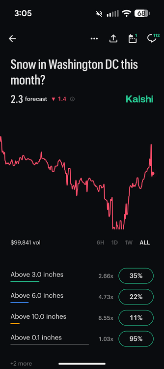
-
Feb 22nd/23rd "There's no way..." Storm Thread
Paleocene replied to Maestrobjwa's topic in Mid Atlantic
Hey if we get skunked at least you win "most epic digital snow map in a specific threat tracking thread" award 2026 -
Feb 22nd/23rd "There's no way..." Storm Thread
Paleocene replied to Maestrobjwa's topic in Mid Atlantic
GEFS really leaning into the tucked solution as we get closer. At hour 84, the OP run that just annihilated most of us was well west of where the offshore cluster is. The low was over the southern Chesapeake.