

Paleocene
-
Posts
1,396 -
Joined
-
Last visited
Content Type
Profiles
Blogs
Forums
American Weather
Media Demo
Store
Gallery
Everything posted by Paleocene
-
Same here. Don't want to disappoint a 7 y/o. Good luck! I'm prolly 2 miles west of you, a bit higher up.
-
I know when I start switching my expectation from rooting to snow to rooting for sleet, things aren't looking good. I was hoping this would be like the feb '14 miller A(?) storm that gave me 5-7" ish inside the beltway (plus rain/sleet mix) while NW areas got 12"+.... but last 24 hours of trends have me thinking that's an unlikely scenario. But such is climo where I am :-D
-
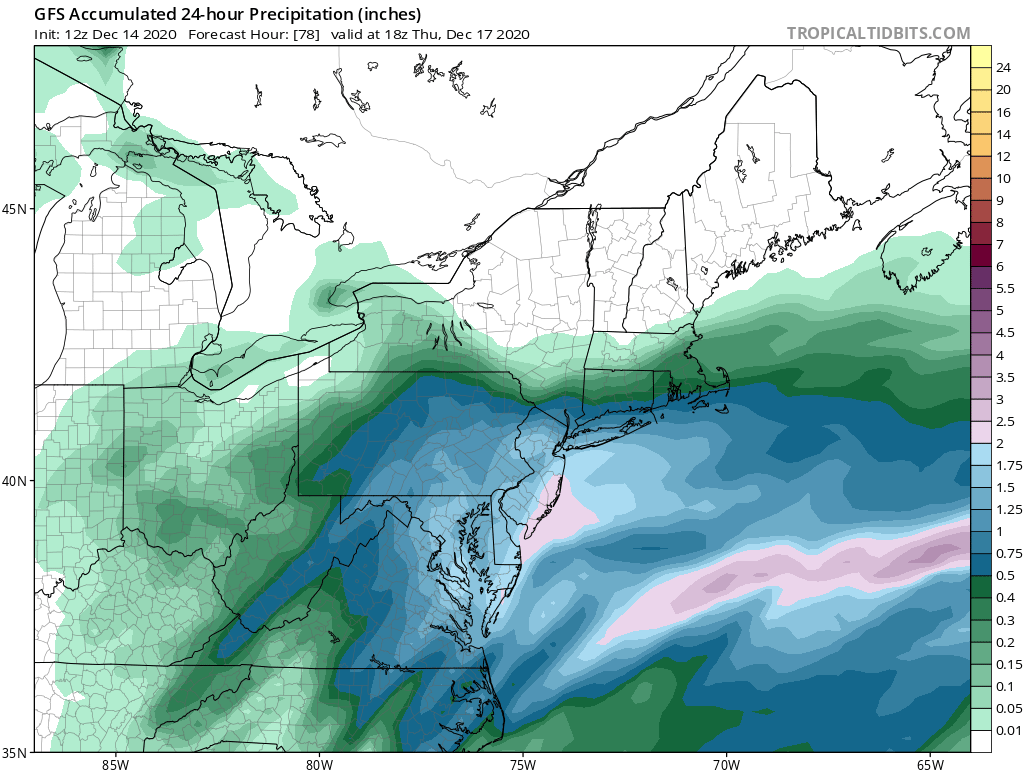
12z today for 18z thurs 24 hour precip, versus 00z last night for same time. I see a different spatial distribution especially comparing north of M/D to south. I like being centered just outside DC in that 1.5 inch zone..prob is its looking increasingly liek a chunk of that will be rain/sleet :-(

b.thumb.png.4027e55ba16b8e3291530f622a285215.png)
-
Man, I am loving that look on the 18z GFS. Please GFS gods, give us that heavy axis here right along the fall line. I'm in Silver Spring (just east of downtown near route 29) and I'm on top of a hill at 326'. My friends in Hyattsville or Brookland DC could see significantly less than me, a few hundo feet lower.
-
I have a four pack of these crispy boys waiting in my pantry. Got them from the source at dogfish HQ in Milton in November. Will def crack one if it snows on weds eve.
-
That'll be a hell of a midnite jebwalk.
-
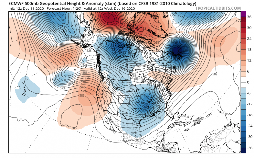
This looks really pretty to my meteorologically uneducated eyes. Pretty cool to see that 50/50 and the block. I remember past discussion of neutral or negative tilt being desirable for the area of low pressure in the southern US, this is relatively neutral right?
-
This is good news indeed. I'll take my chances inside the beltway with that. 5 days out to get temps right...
-
Great CAD signature at 120 hours on the euro.
-
Here are the fresh GEFS ensemble lows. that is a hell of a cluster east of assateague
-
Don't want to spam the thread with pics but holy smokes the CMC buries i-95 corridor
-
cranking!
-
GFS 12Z on 12/11, for 12z thurs 17th. Capturing the projected wednesday storm 12/16
-
Freezing line at hour 126, at the surface, basically parallels I-95 south of baltimore. 850s line runs through charles, anne arundel, queen annes
-
CMC had too much Molson.
-
Not bad
-

Mid-Atlantic winter 2020-21 snowfall contest
Paleocene replied to PrinceFrederickWx's topic in Mid Atlantic
BWI: 12.2" DCA: 7.5" IAD: 14.5" RIC: 6.0" SBY: 7.0" -
I still haven't had to turn on the furnace, seeing if I can hold out until Friday/Saturday. Indoor temp dropped to 65 once but has held relatively steady for the past month around 68-70. Don't think that will last if lows in the 40s/30s happen. Turned on the AC once when it was humid around Sept 20th, but it has been a very good window-controlled HVAC season this fall.
-
I am noticing some color in maples and dogwoods in my inside-the-beltway neighborhood this week. Poplars are still deep green but they're going to start to tinge yellow in a few weeks. The changes seem a bit early this year, not that I mind! Here's a photo of a dogwood on the NW side of my house that's mostly under a canopy of poplars.
-
Dry as a bone in my corner of Silver Spring since the middle of last week. Lawn is becoming thirsty, even in the shade.
-
Thicc chunky bois floating down in east silver spring. Almost all snow. Temps still at about 35 though.
-
-
I'm having rain-radar hallucinations; it's been a while without precip in Silver Spring. I'm nowcasting this storm in my head like its late January and we're expecting 1.0QPF of frozen, lol. Very low cloud cover inside the beltway in Maryland, no moisture yet.
-
Got what I expected here in College Park. Took a jebwalk along the NW branch of the Anacostia in some light sleet. Wondering if we'll get that second wave of ice...
-
thicc and juicy snowy bois are spinning down in college park. we're holding strong at 28/28... unusual, as we're usually part of the UHI/fall line crowd that warms up.
b.png.9dbe5c19d86629dcc626c9744bf39f00.png)


