Paleocene
-
Posts
2,054 -
Joined
-
Last visited
Content Type
Profiles
Blogs
Forums
American Weather
Media Demo
Store
Gallery
Everything posted by Paleocene
-
Good thing the NAM has never been wrong
-
No idea who this is but i like what they're saying
-
I remember being outside with my kid 48 hours after the storm and it was drip drip drip in the warm January sun. The way it can really cook around here that time of year lol
-
Is this transferable across space and time? If so I'll drive you to Wisp this weekend for $3k
-
Sref is a JV ensemble. This thing is gonna jackpot DC and Baltimore
-
I hope the broader Baltimore crew hits on this one. 4 plus inches. They're due
-
rain in georgetown
-
-
I want that 0.3 contour over my house please.
-
@Jebmanthis is an all time jebman post/dispatch from the fringes of metropolitan coruscant, i mean Austin. Good luck to you down there. I havent been since 2017 and I guess I shouldn't go back!
-
Dawg why do you think we are on this forum. I'm here to look at colorful maps and dream about snow
-

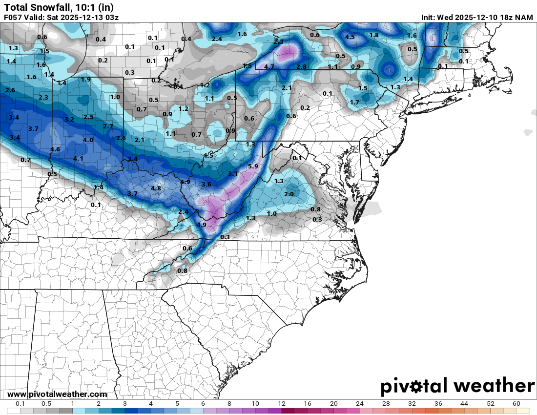
12/12: The little Friday clipper that could? Or won't.
Paleocene replied to dailylurker's topic in Mid Atlantic
This is wildly off topic but good to hear. My wife and I talk about moving somewhere more rural when the kids are older, and getting out of the silver spring rat race. I don't know where you lived in Rockville, but how do you feel about all the driving you have to do in a rural area? The biggest thing we like about where we live is we can walk to schools with the kids, and walk to a lot of daily errands like the post office, grocery, library, health and personal appointments, etc. I really don't drive much. I think I would get over the driving because I grew up in a place like that, but my wife didn't. Anyway, off topic but I hope you get a lot of snow and it sounds like the trade-offs were worth it to GTFO from the DMV inner suburbs. -
12/12: The little Friday clipper that could? Or won't.
Paleocene replied to dailylurker's topic in Mid Atlantic
I don't have the ultra zoomed in maps, but here's the cville jack on 18z NAM. maybe GFS will save points north
-
12/12: The little Friday clipper that could? Or won't.
Paleocene replied to dailylurker's topic in Mid Atlantic
paging @SnowenOutThere, looks like cville jack again. -
Sign me up for 0.3 of frozen
-
I went to bed once overtime was about to start, because I knew they would blow it after that debacle that was the regular part of the game. You made the right call lol
-
Looks like a great weekend to head for the hills and go out to Deep Creek... a foot plus via 10-1 ratios.
-
Feels like Deep Winter (TM) in Silver Spring. Heavy overcast, 30 degrees, 7 degree dew point, sometimes a bit of wind. Cold!
-
Temps dropping and moderate snow... that's the dream combo!
-
Off topic but have you ever gone to flag ponds nature park in calvert? North of the cliffs so worse for snow today, but gorgeous trails with huge trees, and less people.
-
Stay strong, sending good thoughts your way. Otherwise, hope southern end of this forum gets a dumping tomorrow. My brother in law is an asst. principal in Richmond public schools, and he for sure could use a day off!
-
@dailylurkerjackpot you and me
-
Surprised to wake up to a car topper here in silver spring inside the beltway. Roads are clear because MoCo salted them
-
Montgomery County Supernintendo of Schools just sent this to everyone: We want to connect with families following this morning’s weather event and the concerns we’ve heard from some of you. We know that winter weather—even when light—can add stress, change routines, and make the morning feel uncertain. Our decision to open under Code Green (Normal Operations) was made after a thorough review of the latest weather data, road reports, and updates from our transportation and facilities teams. At our morning decision deadline, all indicators pointed to light snow with minimal expected impact to bus routes or school buildings. That is exactly what we saw this morning. Schools and offices opened safely and smoothly as could be expected, and instruction and services continued. That’s not to say there weren’t issues - there were. We also have issues every morning. We know that today’s decision seems incongruent with Tuesday’s decision. We are learning from each weather event, even when all we have to go on is forecasts, imperfect, or incomplete information. A few schools reported a small number of staff absences this morning, which is not uncommon during winter weather. Many of our employees commute from across the region, and conditions can vary greatly from one area to another. School leaders adjusted quickly and learning continued. When winter weather comes our way, we will be vigilant even when the situation seems uncertain, our transportation and facilities teams stay in constant communication with local government partners and neighboring school districts and of course, we’re checking multiple weather forecasting sources. Today we even heard from many in our community about exactly what was happening in real time right in many neighborhoods. All of this added to helping us to make our decision to open on time. Winter has only just begun, and each weather event gives us new information that will help us improve for the next one. We will continue to communicate clearly, act with safety in mind throughout this winter season. We’re in this together.
-
We need the cold air first to win (at least in UHI-world). So i'll take the cold and hope for the best.