

Paleocene
-
Posts
2,052 -
Joined
-
Last visited
Content Type
Profiles
Blogs
Forums
American Weather
Media Demo
Store
Gallery
Everything posted by Paleocene
-
Line building out in the 81 corridor just before 4pm.
-
HRRR and NAM both swing a line of storms through NOVA-DC in the rush hour window. Fingers crossed.
-
Dumpage
-
Lots of booming and darkness to my west near downtown silver spring. Hoping the cell parking over the 270/495 split comes this way.
-
Exactly right - I just came in from a morning walk an hour ago thinking it would be cool in the house, nope, gotta crank the AC again. Stifling! Picked up a quarter inch in some scattered showers after 8pm last night. Paltry but things are damp.
-
Got maybe 0.15" yesterday in a brief shower. And that's basically it over the last week - squeaked out a half inch last Monday. The sunnier neighborhood lawns are browning out, but its still decently green here
-
That storm up in the moco hoco borderlands is loud and tall and looks productive from here in silver spring maybe 15 miles south
-
Getting some storms out in the sticks in WV. Cooling things off... Eating outside at a pizza place
-
Near Lost River State park in WV, sitting at 92. Not bad in the shade, DP is below 70. At the park pool this afternoon it was pleasant. Water was refreshing, light breeze, air temp probably 95 at the worst. A hot summer day, but not urban heat island death. All these trees out here keep the ground nice and cool. Plus maybe 1500 feet elevation
-
Went for a jog just now before the sun goes above the treeline in my nhood. Great way to start sweating in sixty seconds! We're bailing and headed out to WV later this am... Maybe it will be 95 instead of 101 lol
-
Same issue for me; up to 79 with upstairs unit running. downstairs unit doing fine - lowering that temp to help it keep up.
-
These clouds popped over central/southern MD since 11am. Preventing the searing heat from cooking just a tad.
-
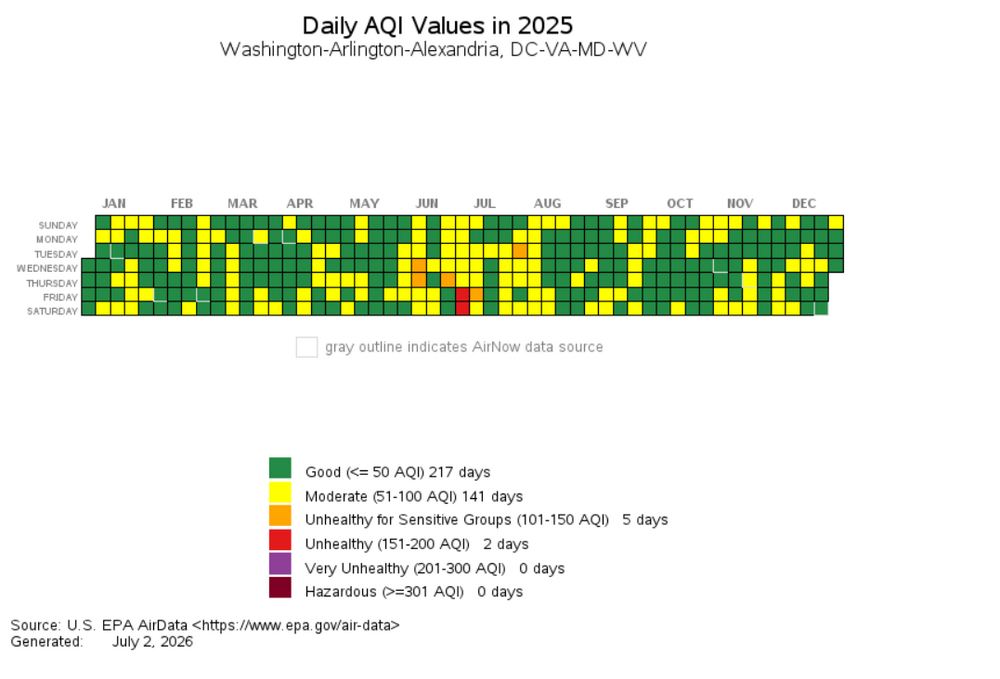
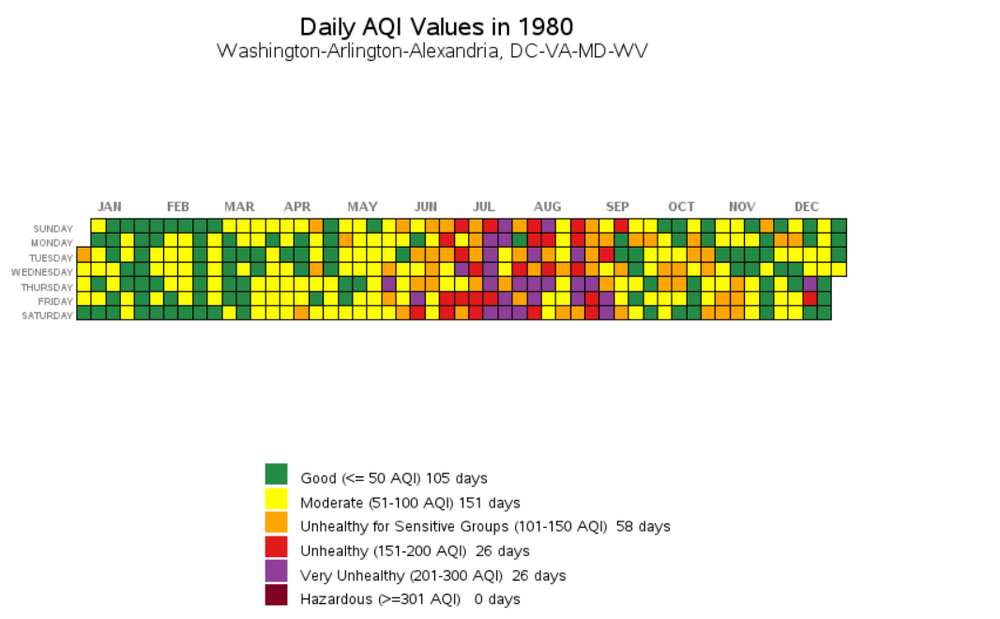
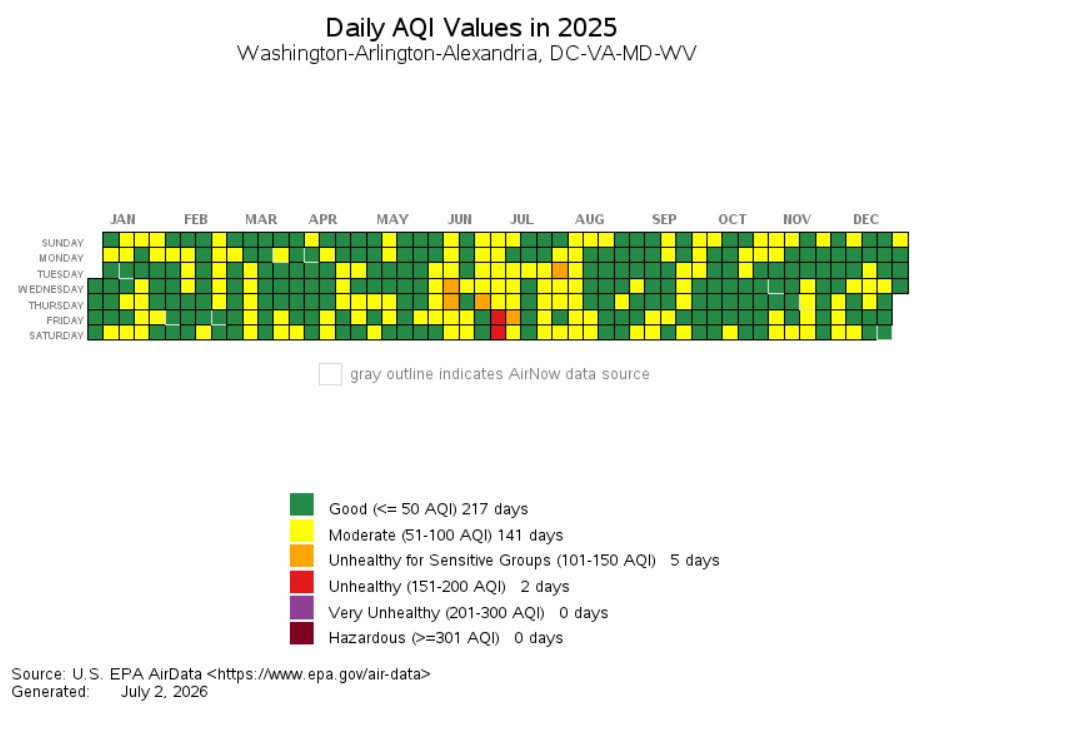
Hear hear - I work in urban planning so think about this stuff a lot. 2025 versus 1995 for the AQI... great visualization tool on this page https://www.epa.gov/outdoor-air-quality-data/airdata-tile-plot (which I think I got off this site years ago). sorry for the digression.. edit - adding 1980 for fun - thanks clean air act
-
Mesonet picking up a DP of 79 with air temp 94 in college park. cooking. "apparent temp" (is that heat index? @Eskimo Joe) 111! @dailylurker are you doing a heat hike
-
That would be impressive. I can't recall a reading at DCA of 105, but admittedly I don't track summer heat . Edit:: Google tells me this happened in 2012. I was here and it was super hot, just don't remember the 105 reading
-
It doesn't look great this year because MBY has been relatively dry. Ignore my sad garden lol. Basic story: we bought the house in 2022, very close to the Silver Spring metro in one of the nearby single family neighborhoods. It's on a roughly 50' x 200' lot, so it's a very deep narrow backyard behind the house. It was owned by an older gent who lived alone, and did the absolute bare minimum. I'm talking mow the lawn and that's it - he let a few azaleas grow, but didn't plant anything. Rhododendrons in the back quarter of the yard were overrun by wild grape and other vines. There was a mix of turf grass, weeds, and vines back there. But a lot of it was just urban/suburban weedy unkempt mess. In the summer of 2023 I noticed we had a decent number of fireflies. Less than what I shared in that video above, but enough to notice and appreciate. So I looked into a bit and decided to just let the back quarter of the yard be "wild" - I don't cut the grass, and I use a weedwacker on the more annoying vines that are trying to climb shrubs and trees I'm planting. The grass is scrubby this year because of a lack of rain - in previous years it was more of a rolling field of grain type look. My brother lives in upstate NY on 16 acres of former farm field which is now a meadow slowly returning to forest. He has an absolutely insane number of fireflies that put on a show like in my video, but scaled up by 50x. So I'm trying to replicate that in miniature. I've added a few native trees (swamp white oak, tulip poplars that grow from seedlings and are now 10+ feet tall just in a few years, red maple, red and white oak); and reclaimed the rhododendrons. I think the other important thing I do is drop a bunch of leaf litter back there. Instead of putting it all on the curb in November, I go back there and dump 4-5x trash cans worth of birch, poplar, oak, etc leaves all over the place. I'm a bit worried that the "meadow" is this year losing a battle to wild grape, morning glory, virginia creeper, and even some english ivy that is just everywhere around here. I may have to eventually rent some sort of turf grinder/soil churner type device and replant wildflowers and native grasses. However, 2026 is definitely the best firefly year of the past 4. Sorry for the digression! Back to weather. It's nice out because it's cloudy.
.thumb.jpg.03f6f96d42735dc5f48d3b14e3f57037.jpg)
-
https://streamable.com/010pjd Backyard fireflies peaking in silver spring. This is after three years of curating their habitat with a couple hundred square feet of "meadow" and dumping leaf litter in a few areas. Everyone should do it!
-
Hey, that's me! Getting some decent rain the past hour or so though.
-
Got fringed on the first round and missed the strong storms of round 2 to the south last night, picked up 0.25" ish from the combo. Drizzle this morning...hoping to make it to an inch
-
Northwest flow is great in Ohio right now. Taking my older kid to cedar point today (he's in the roller coaster phase of early teen years). Sunny, crisp, low humidity, 10/10
-
Electric in my backyard last night, doing the shimmering/flickering deal. Everyone should leave some high grass and leaf piles in a few patches to give them a fighting chance. I'm just a few blocks from the asphalt and concrete canyons of downtown silver spring... But I have many lightning bugs
-
These days make the 95-100F with 70 dew point days tolerable
-
10/10 morning right now
-
Love the 90 degree day tracking. Who's tracking 70+ degree dew point days? Yesterday was a nice respite but back over 70 here inside the beltway. Yuck. Slightly more tolerable with cloud cover and a breeze
-
I saw on reddit that it was the blue angels, tho I didn't catch it. Practice for the 4th, perhaps?


.jpg.65d89b14f566b71e04b24cab76a81d9d.jpg)