EastKnox
-
Posts
162 -
Joined
-
Last visited
Content Type
Profiles
Blogs
Forums
American Weather
Media Demo
Store
Gallery
Everything posted by EastKnox
-
Hard to say. I looked at temps on wunderground and it looks like a little warm nose trying to push up west of the plateau ahead of the main warm front.
-
-
I've seen that page too. The page hypes about every GFS fantasy storm that pops up. Those thousands of followers swear by the page's "forecasts." I can't help myself to occasionally comment and attempt to educate a few of those thousands.
-
Yesterday around 5 pm, it appeared to me that a few cumulus had formed in the wake of the smoke. I wondered if the smoke/heat provided a little extra lift in that area, but thought I was nuts for thinking so. I was in the powell area around 8 pm when that second trailing storm passed south of the fire and noticed on radar (and outside observations) that the outflow boundary from the second cell pushed the smoke further north into the halls and powell area. The smell was distinct.
-
Just posting to make sure this subform is still working. MRX WWA stands out like a sore thumb.

- 116 replies
-
- 1
-

-
- banter
- chewing the fat
- (and 5 more)
-
Education and Questions/Discussion Regarding Weather Features
EastKnox replied to EastKnox's topic in Tennessee Valley
Found this gem from WFO Louisville for all of you severe weather trackers. SvrWx_Fcstg_TipSheet.pdf -
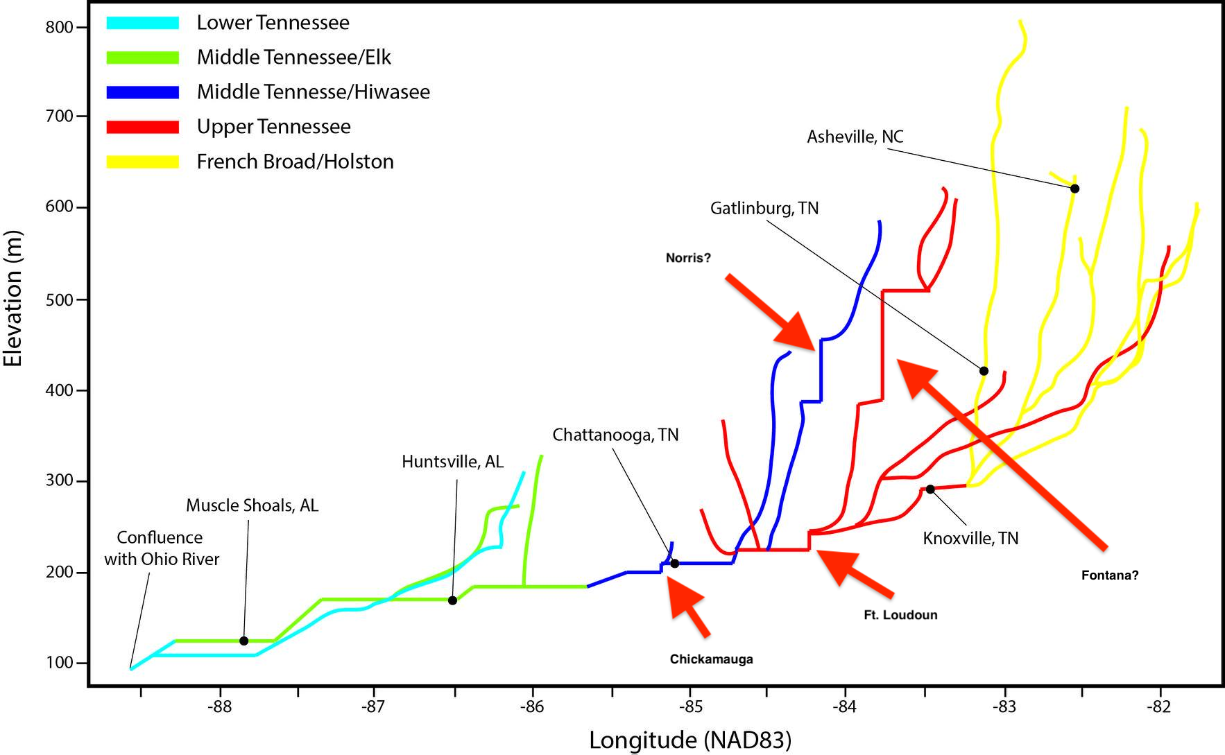
That's why I put question marks because it doesn't exactly line up (obviously the map isn't designed to be to scale). The vertical drops seem to match dam heights, but the placement relative to other features doesn't seem to fit in correctly. Here are some longitude coordinates of the dams: Norris: -84.1, Fontana: -83.8, Ft. Loudoun: -84.2, Chickamauga: -85.2, Watts Bar: -84.8. Also interesting in this graphic, Knoxville is set too far east. On the map it is -83.4ish, in reality it is -83.8 (confluence of Holston and French Broad Rivers). Weather must be slow when we are dissecting a river watershed graphic.
- 116 replies
-
- 1
-

-
- banter
- chewing the fat
- (and 5 more)
-
I tried to identify some dams from this map.

- 116 replies
-
- 4
-
-
-
- banter
- chewing the fat
- (and 5 more)
-
Ok, ok...one more and I won't beat the dead horse any longer. Excerpts from this article on cnn.com : https://www.cnn.com/2019/03/05/us/alabama-tornado-survivor/index.html ----------------------- "He's pretty banged up .Really sore. He said that he heard some loud noises. He didn't even know that there was bad weather in the area. I didn't know either," she said. "My mom told me there was supposed to be bad thunderstorms, possible tornadoes. But I mean, we hear that quite often whenever it rains bad down here," ------------------------ So sad that people choose not to be aware of potential bad weather. They did make a good point in the article that they mostly watch Netflix, so maybe not be exposed to local bulletins. I think social media fills that gap, however, there are too many social media weathermen posting model data to the masses and each of those posts becomes "another time when the weatherman was wrong" in their minds. I did chuckle a bit when reading the part of the second quote above equating tornado watches with heavy rain. I often wonder how many people think that way.
- 116 replies
-
- 1
-
-
- banter
- chewing the fat
- (and 5 more)
-
First of all, thoughts and prayers for families and communities that experienced loss of life and property yesterday in Alabama. Next, does anyone else get annoyed that the media overplays the "we only had 5 minutes warning" statements? Yes, the actual tornado warnings were issued at 1:58 p.m. local time about 7 minutes before the tornado touched down. But with SPC pinpointing that area with outlooks a few days prior, Enhanced risk the day before and Tornado Watch at 11:04 a.m. local, there was plenty of warning that this could be a possibility. I know I'm tuned into the weather because I love watching it, but I think more and more people are becoming complacent with watches and warnings and largely ignoring them. The WFO's are in a tough spot between calling too many warnings and having people become immune to them - then waiting too late to call warnings and response times are not adequate.
- 116 replies
-
- 4
-
-
- banter
- chewing the fat
- (and 5 more)
-
I love the Cherokee Purples. I haven't been able to put out a garden for the last 2 years but if I get a chance to grow a few tomatoes this year, Cherokee Purples it is.
-
Getting closer to the event, I particularly enjoy studying the actual and model soundings for a given location for severe wx; since tons of data is to be had in just one picture.
-
Education and Questions/Discussion Regarding Weather Features
EastKnox replied to EastKnox's topic in Tennessee Valley
Thanks for putting this here, I had wondered if there was an easy way to put that part of the discussion into this thread. -
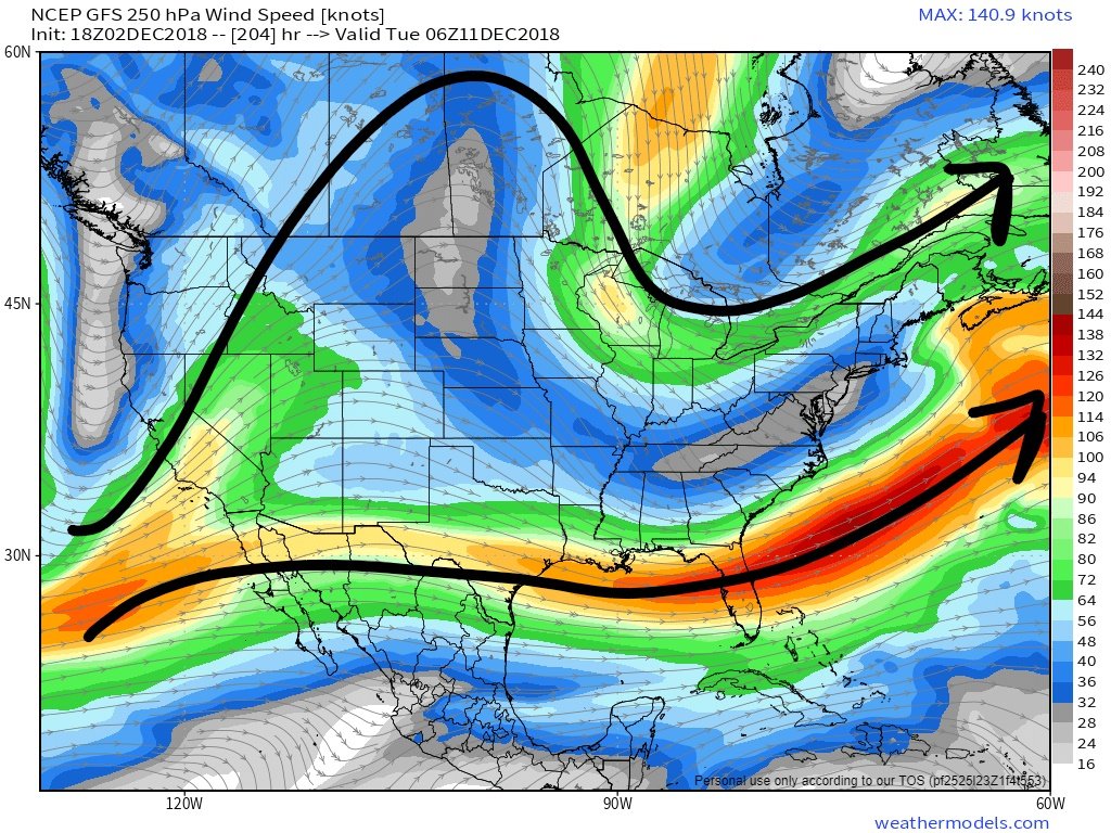
I have started this thread in order to have a place to ask questions about weather phenomena and features we see in models. In particular, I'll see some discussion happening about an upcoming weather event, but may not understand all of what I'm reading. I don't want to muck up the main discussion with general questions so I thought that a separate thread could be helpful for us with less knowledge. Of course, this isn't an atmospheric sciences course condensed into a forum thread, but maybe a few tidbits of info will be shared that we can benefit from. I'll start with one that relates to our current situation. I hear a lot of about split flow of the polar and subtropical jets. What is the best way to identify the split flow? Have I identified it correctly in the 250 mb winds chart below, or would you look elsewhere? (500 mb) and do you look for certain heights (like 540 dm in the 500mb chart) to identify the polar jet?