greendave
-
Posts
65 -
Joined
-
Last visited
Content Type
Profiles
Blogs
Forums
American Weather
Media Demo
Store
Gallery
Everything posted by greendave
-
April Fools anyone?
-
Beauty is in the eye of the beholder. This winter - the story of the haves and have nots. IMBY - we had storms to track, but ultimately still below average snowfall for the year. In a year where New Orleans, Florida panhandle, CharlestonSC, grand strand and tidewater VA out performed us, its a tough pill to swallow when several "big dogs" were possible, but never came to fruition. In general I acknowledge the "southeastern states" region - probably a solid B+ but that is very sporadic/inconsistent. For me personally, given the extremely high potential of multiple events, but with ultimately low results I give this winter a C-/D+. That being said, I've accepted the fact, applied first dose of Prodiamine before yesterday's storms, the bass will soon be moving up to spawn, and maybe - just maybe (weather related) the morels will give a good flush this year.
-
February 19-20 Major Winter Storm Threat
greendave replied to NorthHillsWx's topic in Southeastern States
This is undoubtedly the best thing that has ever occurred on these forums. Period. -
Feb 2014 had back-to-back storms that I'd argue gave moderate tree damage in the CAD favored areas b/t Triad and Triangle. I know in Burlington - we had a 4-day power outage with the first storm if memory serves me. Noted - Wake and immediate areas avoided these.
-
Fwiw- interesting microclimate observation. made a trip to Greensboro this am - in the vicinity of US70 & Huffine Mill Rd. There was a noticeable amount of ice in the tops of the trees just north of US70. Nothing on surface and did not notice ice anywhere else b/t west side of GSO and Burlington. Back home and noticing that small little area is roughly 40-100’ higher elevation than anywhere else in the immediate area. Cool!
-
micro flakes just started Burlington, NC (1 mi ESE of Elon)
-
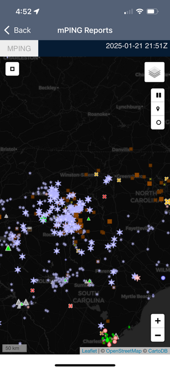
fwiw - concentration of mPING snow reports just blossomed b/t HKY and CLT - encouragement perhaps along (NW side) of I-85 corridor ?
-
or yeah - what he said
-
My somewhat scientific (but not professional meteorological) answer. Asheville is in a basin completely surrounded by higher terrain. Orographic lifting on the periphery (windward), downsloping and for various reasons - less precip. on the leeward. I believe its true Asheville and Roanoke, VA are historically the "driest" urban/metro areas East of the Mississippi due to similar geographic situations.
-
I've seen it before. Alamance Co.: Swepsonville - frz rain/sleet/very little snow mix. They ended with a sloppy <1" accumulation. 4.8miles as the crow flies - Hwy 62/Alamance Rd exit (Home Depot/Sheetz) pouring big snow. I'm 2mi. NW of there - we ended with 5-6" of all snow if memory serves me....I-40/85 is real. Hold the Line.
-
-
Dr. Jonathan Wall with addl sources of evidence to support the CFS. https://twitter.com/_jwall?lang=en
-
Oh how I miss Boone winters....and football......and food....
-
Well - of 272 NFL games this year, there's a running average of 13.5 games that go to OT. So there's always that 5% of OT turning out in our favor....and look how much chaos ensues after the 2min warning.
-
Well - if you know what freezes over - i'll meet ya'll for a good plate of 'cue, burger, or a hazy IPA if that's your thing....lil' ol' Graham is coming around....there's even a little barcade we can rent out....do i smell a Spring Equinox party?
-

-
1 mi ESE of Elon. Microscopic flurries.
-
point is - the atmosphere "appears" to be juicing up. And we already have groundtruthing in areas lacking echoes- most recently union co. nc
-
sharing is caring and winning is giving.... let's reel it in!
-
its already been eluded to - but radar beginning to liven up - particularly around Wadesboro, Albemarle, and most noticeably to the west - Wilkes County.
-
1 mi. ESE of Elon and i'm finally seeing flakes mixed in @ 7:09pm - 34.9 degrees
-
#truth
-
January 20-22 “bring the mojo” winter storm threat
greendave replied to lilj4425's topic in Southeastern States
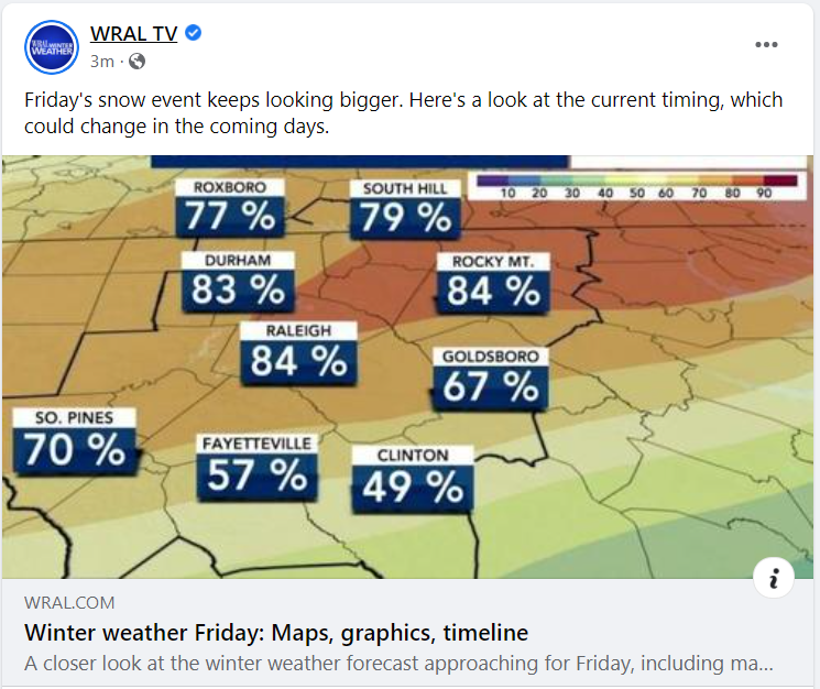
Brad P. on board 4-6" bullseye on RDU - extending west to Burlington, as far south as fayetteville. 2-4" ring from GSO down to NW and W side of CLT.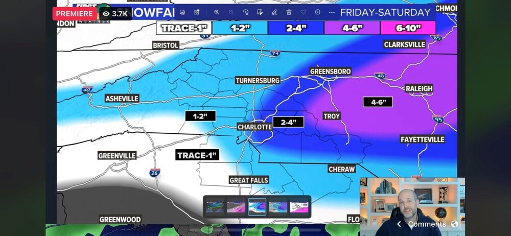
-
January 20-22 “bring the mojo” winter storm threat
greendave replied to lilj4425's topic in Southeastern States
I'll leave this here....posted at 11am.