GunBlade
-
Posts
474 -
Joined
-
Last visited
Content Type
Profiles
Blogs
Forums
American Weather
Media Demo
Store
Gallery
Everything posted by GunBlade
-
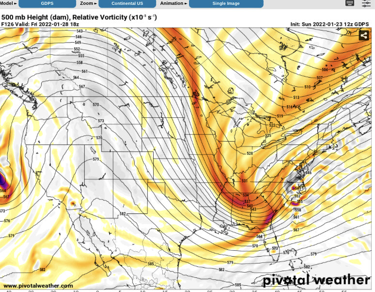
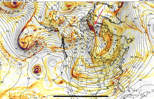
Yea we need that ULL diving down from the arctic to be a little stronger and/or slower to help those waves dive down more in the plains instead of coming down through the Midwest/Ohio Valley. Canadian is showing the storm now as well. Still a little late to phase but nice to see it showing up. Biggest thing I’ve noticed is Canadian and others have the energy about 12 hours ahead of GFS which has caused them to not phase or dive down through the Ohio valley and phase too late. In a couple more days the location and timing of those waves in Canada should become clearer.
-
Canadian didn’t get it done either. But the players are on the field. Pay attention to that ULL in Canada on future runs. It helps drive the other waves south and west in the 18z GFS screenshot. It’s much weaker on the 00z GFS and let’s the other waves coming from Alaska slide further east and down through the Midwest instead of the Great Plains. The Canadian is even weaker but then also a little faster with the energy coming down from the arctic and ahead of it. Allowing those waves to slide even further east and then ejecting some energy southwest into the plains. The remaining northern energy eventually phases with a third piece of energy coming down from Alaska. By then though it’s so far east and north the low forms off the coast of SC instead of down in the Gulf.
-
For anyone who hasn’t done it let any long range model auto play the entire run and watch all of the northern waves coming our way, diving down, one after another and southern waves coming across Texas and the gulf. The past few years we can’t get this type of pattern for an extended duration. Our best bet for big snows down here is those waves coming together perfectly to create the storm the GFS has been hinting at next weekend. I feel like we used to hope for lows coming into the gulf being suppressed down to Cuba because we at least had a shot at the high moving out faster and the low turning up the coast. Instead we’ve had app runner one after another or no cold air. Whether next weekend happens or not, there are ALOT of opportunities in the next 10 days for those waves to give us at least a shot at something good and temps look to be as good as we can hope for in the SE. And in the end at least we have something to track and hope for. For the pessimistic Ted Lasso fans, it’s the hope that kills you. The rest of us will let you know when there’s no hope again.
-
 So does this!
-
After several hours of snow the latest HRRR totals look nearly the same as they were showing for the whole storm earlier today lol. Gotta love SE winter weather.
-
That was my thought as well. What the ice doesn’t bring down the snow piled on top at the end very well could.
-
For anyone near the coast in the freezing rain how are things there? Radar has looked no bueno.
-
Rates really picking up here in Matthews as well. Going to be a pretty sight tomorrow morning.
-
I think most people down here see snow so little and it melts so fast they want totals over duration. For me, there’s nothing better than watching it snow from sunrise to sunset. But in the end I’d prefer higher totals over duration in hopes it sticks around for more than 1 or 2 days to enjoy with the kids. For reference, the storm last week was Charlotte’s first 1” or more snow in 1,133 days. Pretty dismal. Every snow could be the last one we see for years so emotions run high with every one.
-
Nearly every model is showing the western snow shield starting to build back up around this time and drop a couple inches in CLT between now and 1 am. Hope they’re right and we can somehow squeeze out a decent little event here.
-
Right now it’s 30 in Matthews with a -7 dew point….wow.
-
January 20-22 “bring the mojo” winter storm threat
GunBlade replied to lilj4425's topic in Southeastern States
Sorry was having issues on VPN getting images to work. Here you go.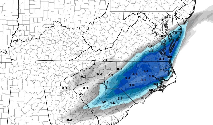
-
January 20-22 “bring the mojo” winter storm threat
GunBlade replied to lilj4425's topic in Southeastern States
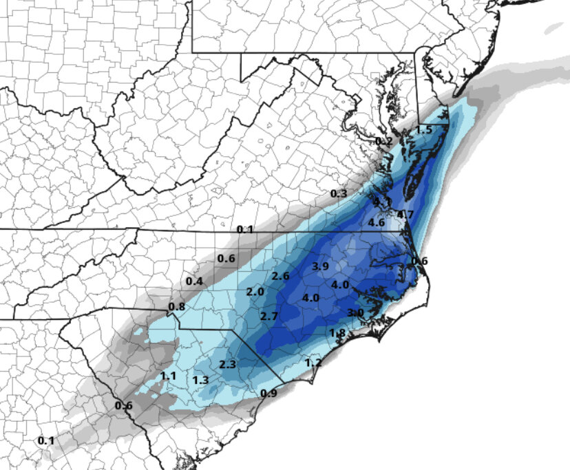
15z HRRR giving CLT a little more love as well with 1.5" this run. -
January 20-22 “bring the mojo” winter storm threat
GunBlade replied to lilj4425's topic in Southeastern States
This does not actually close off to an ULL. That map is also lower level pressure -
January 20-22 “bring the mojo” winter storm threat
GunBlade replied to lilj4425's topic in Southeastern States
RAP is looking great as well. Going to be a good run. -
January 20-22 “bring the mojo” winter storm threat
GunBlade replied to lilj4425's topic in Southeastern States
GFS decreased totals by about 1/2 inch for many areas and even more for some. Northern wave was a little weaker and looks much like the 18z RGEM overall with slightly lower totals. -
January 20-22 “bring the mojo” winter storm threat
GunBlade replied to lilj4425's topic in Southeastern States
18z RGEM actually has lower totals for nearly all of NC and SC outside of the NE corner of NC into VA. Still looks better than the NAM, but moving toward lower totals isn't the trend I would want to see. -
January 20-22 “bring the mojo” winter storm threat
GunBlade replied to lilj4425's topic in Southeastern States
It does (barely) but the northern wave is slightly faster and weaker this run compared to the last run. I wouldn't put much faith in that expansion west of moisture as it is not driven by the ull energy and will be hitting very dry air and is often overdone in modeling. -
January 20-22 “bring the mojo” winter storm threat
GunBlade replied to lilj4425's topic in Southeastern States
Miniscule differences in this run for the NAM so far, doubt much will change for the remainder of the run compared to 12z. NAM definitely did not move closer to the GFS but it doesn't look to be any worse than it's last run... -
January 20-22 “bring the mojo” winter storm threat
GunBlade replied to lilj4425's topic in Southeastern States
NAM so far looks similar but the southern energy looks a little stronger. See how that plays out shortly. -
January 20-22 “bring the mojo” winter storm threat
GunBlade replied to lilj4425's topic in Southeastern States
Canadian made a big step towards the GFS with the H5 looking very similar compared to the prior Canadian run. -
January 20-22 “bring the mojo” winter storm threat
GunBlade replied to lilj4425's topic in Southeastern States
With a typical low yes. But this is more dependent on the northern and southern streams phasing, where that occurs, how much they dig etc... The big Ukie run a couple days ago went neutral/negative tilt right over the NC/TN/SC/GA borders and then closed off even near the coast the next frame. The most recent GFS run for instance is still positively tilted and centered in the piedmont of NC. -
January 20-22 “bring the mojo” winter storm threat
GunBlade replied to lilj4425's topic in Southeastern States
As mentioned a lot, how the upper level energy is handled is what will make or break this for many. There may be a better resource for this but below is the SPC current data to view the 500mb energy. As several mentioned nowcasting, it becomes as much about monitoring current conditions compared to model predictions and subsequent model runs. Tiny differences in this energy has big implications. https://www.spc.noaa.gov/exper/mesoanalysis/new/viewsector.php?sector=19&parm=pmsl# -
I live just south of Charlotte and we were shut down for a week after that storm. I doubt I’ll ever see anything like that again in my life as long as I love here. Yet for some stupid reason, every possible storm on the horizon I hope inside will be just like this… Funny thing is my family moved down from Iowa in 1987 thinking they’d get away from snow and less than a year later Charlotte had its second biggest snow all time in 1988. This 2004 storm was “officially” less than that storm for one day snow but we ended up with over 16” in total at our house. Sad how exciting just 2-4” is now after being here for a storm like that. And yea burrel that Bermuda snow triangle you live in is crazy. I’ve hung around this board for years, never contributed much, and seen that happen to you over and over again.
-
I had hoped to take photos of an ISS moon transit on the 21st. The outlook of snow made that not happening feel better. So I’ll be really annoyed if we don’t get snow either.

