

Newman
-
Posts
2,112 -
Joined
-
Last visited
Content Type
Profiles
Blogs
Forums
American Weather
Media Demo
Store
Gallery
Posts posted by Newman
-
-
18z HRRR looks solid for most across the CWA, WSW criteria met for Berks and the Lehigh valley. Upper Bucks, Chesco, Montgomery as well. Philly itself flirts with the snow/mix line for much of the game tomorrow, but ultimately remains on the "snow" side of the line. Worst conditions in Philly are probably when the storm is pulling through with the last hour or two as temps crash and ratios/rates are enhanced a bit. So, I would expect a snow or snow/mix during the entire game tomorrow with the 4th quarter possibly being the worst.
-
 4
4
-
-
We got a surprise 5" or so of snow in Laramie last night. Was only expecting 1-3" max.
-
GFS looks like it'll be just a bit more tucked than 12z, unless the kicker behind it does it's part
-
20 minutes ago, Violentweatherfan said:
Can you post that map with the warm nose
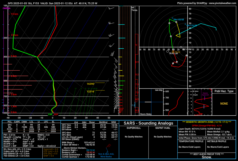
I was just looking at the sounding at PHL around the height of the storm. You can see that warm nose at 850. The column is still below freezing verbatim, but in reality we all know how these things go if they're that tucked.
-
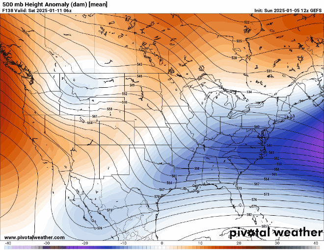
As of right now, I would lean still towards this being a Mid-Atlantic special as compared to an I-95 bomb up the coast to Boston. If there's no phase, well then we have no storm. If there is a phase, the decaying NAO block and 50/50 low should limit how north this got AND there appears to be a kicker wave on it's heels coming down the ridge over the west coast. Anything can happen, but just my early thoughts. We'll see lots of shifting around, probably some good and bad, in the coming days. I would be shocked if the current storm cyclogenesis process looks the same in 5 days
-
1
-
-
1 minute ago, Violentweatherfan said:
With a storm that intense and close to the coast, wouldn’t there be mixing issues. I know it’s fantasy land but just saying.
Verbatim if we took the GFS as is, it actually reaches the latitude of about the DelMarVa and then gets kicked east. It's almost a perfect track for the Mid-Atlantic states. You can actually see a warm nose/WAA in Philly at 850mb, the flow off the Atlantic would certainly bring mixing issues into play for those over the coastal plain. But at this juncture it doesn't matter as you said, let's get the storm to solidify on models first.
-
Major shift on the GEFS
-
4
-
 2
2
-
 1
1
-
-
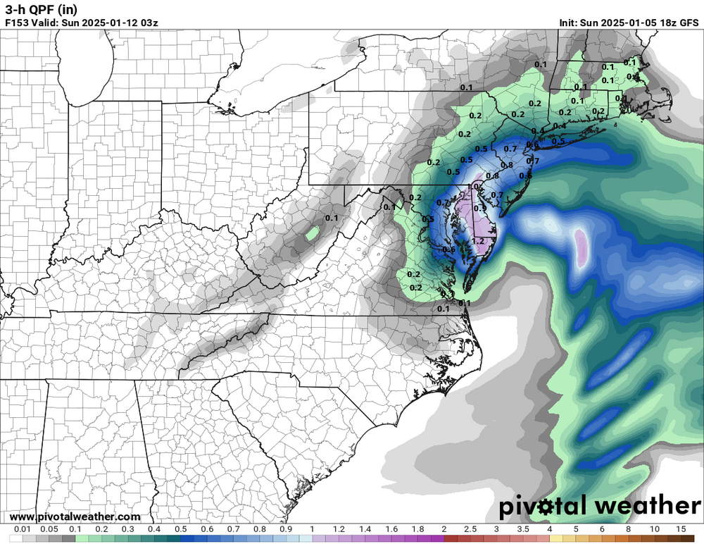
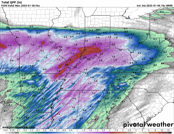
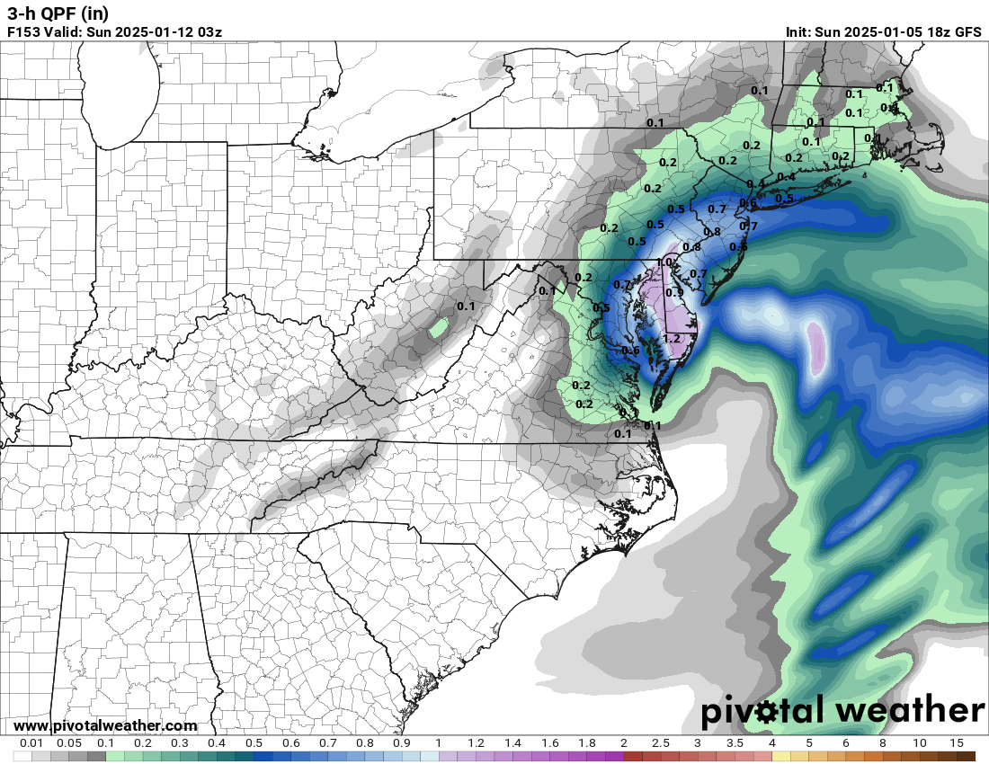
That GFS drops a solid 1"+ of QPF in some locations along I-95 in only 3 hours. That, at a minimum in such a dynamic storm, would drop like 15 inches or more of snow in only 3 hours
-
 2
2
-
 1
1
-
-
Can we talk about the GFS dropping 0.7-0.8" of QPF in only the span of 3 hours? Holy crap, talk about the snowfall rates in that
.thumb.png.25da8fc30cb2d20bc0f33fe0048ac6be.png)
-
5
-
 1
1
-
-
1 minute ago, snowwors2 said:
Seeing it or are you being Nostradamus‼️
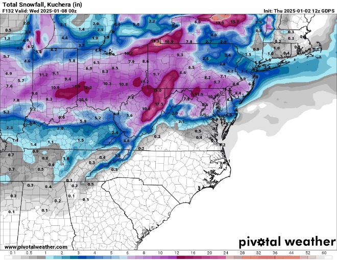
I saw it coming in lol. As soon as I saw the southern energy phase in and the trough turn neutral over the Ohio Valley, I knew a bomb was imminent. But holy smokes, not 2-3 feet right up I-95 type of bomb
-
1
-
 1
1
-
-
This 18z GFS run will be one to remember...
-
1
-
1
-
-
3 minutes ago, Kevin Reilly said:
Thought blue areas were requiring 4” T remembering from distant past off the top of my head?
-
1
-
-
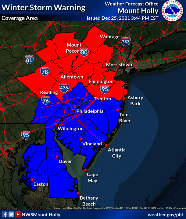
A reminder of the local Mount Holly CWA Winter Storm Warning criteria... Red requires 6 inches of snow and blue requires 5. Winter Weather Advisories are a little bit different, but most areas require 2 or 3 inches of snow. I would think most counties under a watch right now get upgraded to a warning by the morning, maybe not Burlington or Ocean in NJ but we'll see. I still believe the northern guidance (i.e. GFS and NAM's) meet in the middle with the southern guidance (RGEM, Euro, ICON). If that is the case, then just Delaware, Chester, and the southern NJ counties will be under a warning. Also... I am not a Mount Holly meteorologist so I am not speaking on their behalf, though I should hopefully (fingers crossed) be an NWS meteorologist at another office here in the west in a few months...
-
3
-
2
-
-
0z NAM not gonna make many friends here... Shifted south in response to the confluence lobe being significantly further south this run
-
 1
1
-
-
Those on the northern fringes of the snow field should definitely remain cautious. Looking at soundings across the LV and Berks as the precip moves in around 12z on Monday, we're looking at 12 degree dew point depressions. The WAA and moisture advection helps to close that gap quickly, but there won't be any time to waste with regards to appreciable QPF because it's a quick hitter overall... in and out in only 6 hours or so between 12z and 18z on Monday. If the secondary trailing surface low can move north, that would extend things. But as of now, that's looking unlikely
-
1
-
-
18z GFS is definitely a touch better for SE PA
-
1
-
-
Only looking 36hrs out into the Ohio Valley, we're talking QPF differences of 1-2" in some locations between the HRRR (long-range, I know), the NAM, and the RGEM. The NAM and RGEM being drastically different arises from their depiction of the mid-level vort sliding through, of which the NAM is much more potent and neutrally tilted to allow for a healthy PVA regime, the RGEM is simply flatter and less robust. Looking at H5 trends between the two, it seems they are converging closer together without an all-out "fold" of one model to the other. I suppose we'll see, the Sterling NWS AFD is excellent if you haven't checked it out. Also to note... there are some timing differences to make note of, but not *that* large between these models to expect such huge differences
-
9
-
2
-
-
5 minutes ago, winterwarlock said:
why is Mt Holly putting out such high amount for Philly with some of the models not the nam not giving them much
Compared to the prior forecast, totals were shifted southward a
bit as the overall storm track is a bit more southerly on this
set of guidance. However, its quite possible it shifts back
north next cycle, so was a bit generous with the coverage of the
winter storm watch when comparing it to actual forecast totals,
which even at this stage I wouldn`t take as anywhere close to
being in stone. A bit of shifting can still mean several inches
of difference, especially around Philly and points north.
-
2
-
-
Canadian went even more south as well
-
1
-
-
GFS looks good for much of SE PA
-
4
-
-
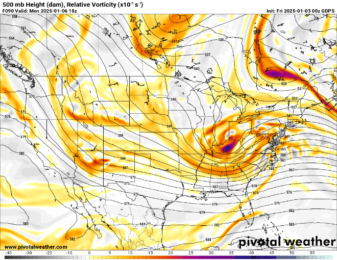
That confluence actually ends up quite a bit further south on the 18z NAM. But the vort itself seems to be more potent and juiced up and that northern confluence almost tries to phase into the backside of our upper-level shortwave trough. So it kicks up the heights ahead of our storm just a bit as it's passing through, which helps to increase positive vorticity advection and hence we see that secondary surface low spawn as it slides east associated with the vort pass.
-
5
-
-
One thing to note is the orientation of the vort lobe north of Maine plays as much a factor as the strength of it, if not more. The models showing that in a zonal W -> E orientation allow it to squash heights much more effectively. Those that keep it more NW -> SE oriented (i.e. the recent 12z GFS) allow for *just* enough space for our system to amplify to get appreciable snows into SE PA
-
4
-
-
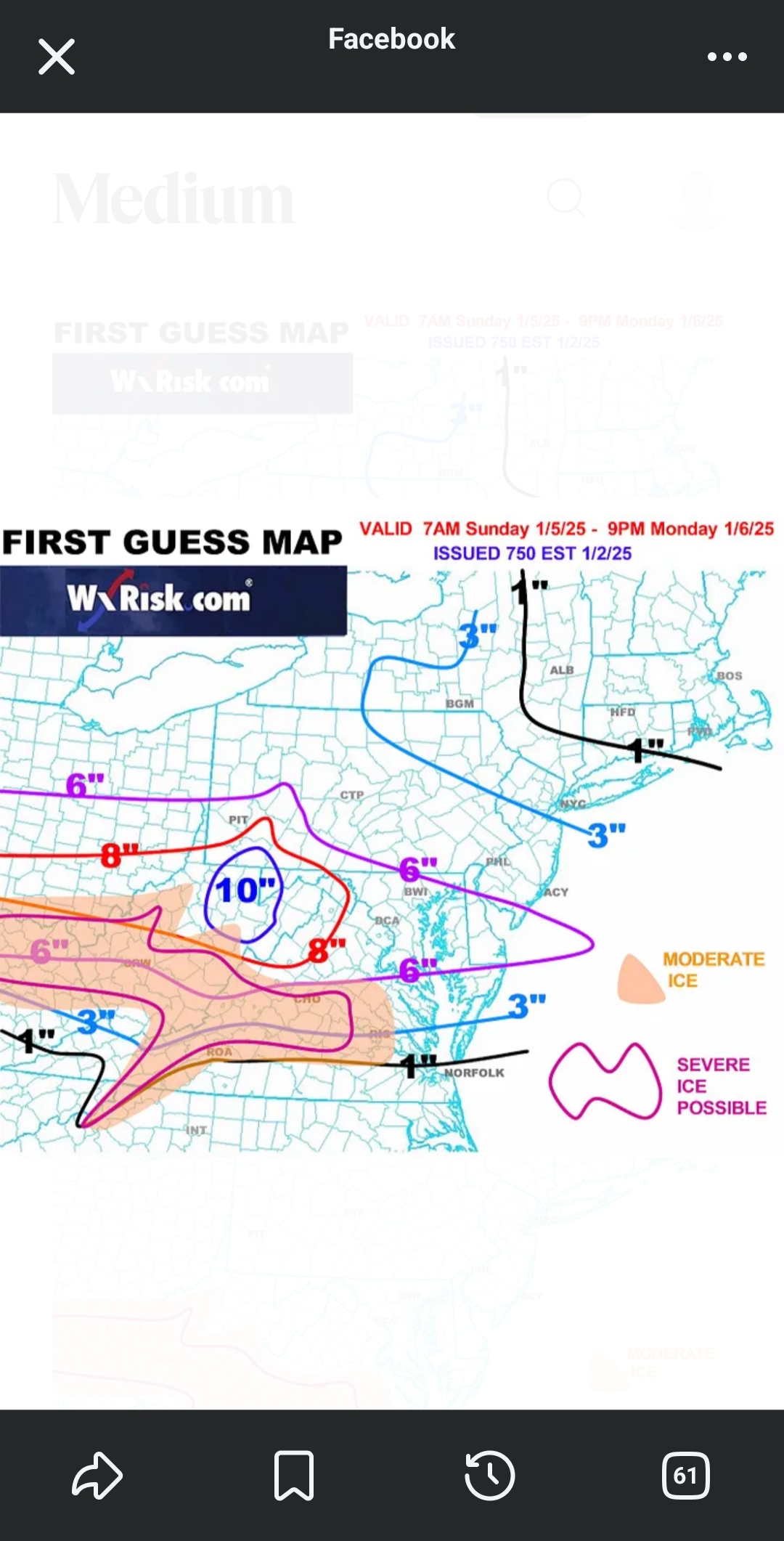
13 minutes ago, tcutter said:
DT first guess map
Not much love for eastern PA
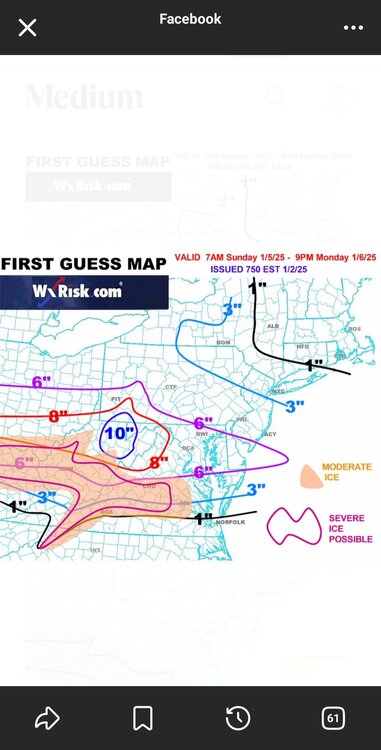
The 3" line all the way up to Easton is actually pretty bullish right now
-
 1
1
-
-
Here's a comparison of the early 0z runs. The Canadian trended slightly stronger with our vort, but it's still positively tilted and not closed off. The GFS and ICON, however, close it off and slide it under the region. The timing is almost identical, and the confluence is lifted far enough north on almost all models to leave room for this to come north. The difference comes down to how potent the shortwave is and if it turns neutral or even negatively tilted
-
2
-

.png.42a7dbe7bc8a7412277b9ecebb1d8550.png)
Central PA Winter 2024/2025
in Upstate New York/Pennsylvania
Posted
Brother in Lititz just measured a bit over 4" in grass