Newman
-
Posts
2,500 -
Joined
-
Last visited
Content Type
Profiles
Blogs
Forums
American Weather
Media Demo
Store
Gallery
Everything posted by Newman
-
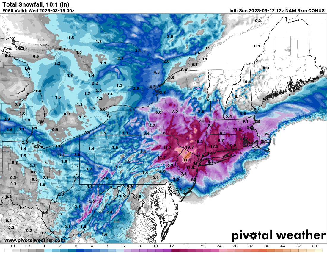
Clearly need to see some other models coming on board. FV3 is still warm and north, as is the RGEM. That is, if you're looking for the insane amounts
-
The cutoff kinda reminds me of Jan 2015 on the Nam runs. Sharp gradient from Philly to Trenton to NYC
-
3k Nam is a Northern Jersey bomb

-
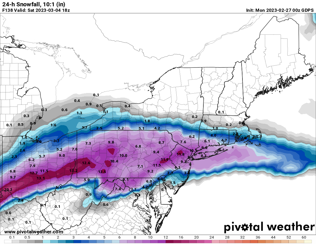
It would be pretty hilarious though if the Euro storm did happen verbatim and we ended up above average on snowfall for the season
-
It was clear as day that would be the base state we'd be working with all winter, I wish I had been wrong!
-

Central PA Winter 2022/2023
Newman replied to Blizzard of 93's topic in Upstate New York/Pennsylvania
Precip has picked back up and it's mostly all sleet, 42F -
Central PA Winter 2022/2023
Newman replied to Blizzard of 93's topic in Upstate New York/Pennsylvania
Sleet mixing in here too -
E PA/NJ/DE Winter 2022-2023 OBS Thread
Newman replied to Ralph Wiggum's topic in Philadelphia Region
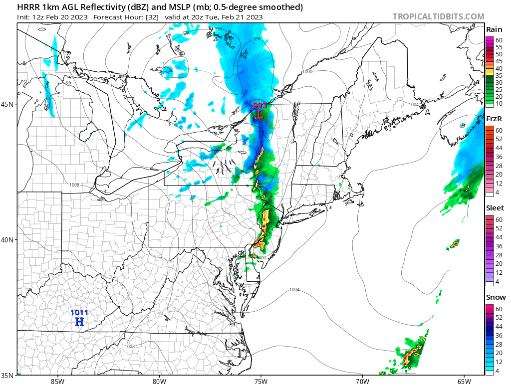
13z HRRR -
E PA/NJ/DE Winter 2022-2023 OBS Thread
Newman replied to Ralph Wiggum's topic in Philadelphia Region
Canadian holds suit for end of week
-
E PA/NJ/DE Winter 2022-2023 OBS Thread
Newman replied to Ralph Wiggum's topic in Philadelphia Region
The 0z NAMs got alot worse though, HRRR and some of the other mesos better -
E PA/NJ/DE Winter 2022-2023 OBS Thread
Newman replied to Ralph Wiggum's topic in Philadelphia Region
18z GFS stops the bleeding for now, has a front end thump for the late week storm -
E PA/NJ/DE Winter 2022-2023 OBS Thread
Newman replied to Ralph Wiggum's topic in Philadelphia Region
Latest HRRR... Mount Holly has issued a WWA for Lehigh County on north with only 1-3"
-
E PA/NJ/DE Winter 2022-2023 OBS Thread
Newman replied to Ralph Wiggum's topic in Philadelphia Region
Yeah the Euro is solid for areas tomorrow night -
The GEFS is going to be slightly improved from the 6z run. There's at least some reflection of a HP up north now. It's not much, but something

-
E PA/NJ/DE Winter 2022-2023 OBS Thread
Newman replied to Ralph Wiggum's topic in Philadelphia Region
Canadian for late week storm -
E PA/NJ/DE Winter 2022-2023 OBS Thread
Newman replied to Ralph Wiggum's topic in Philadelphia Region
If the 6z NAM is right about temps today, then ChescoWx and Kamu might see mid-60s to near 70 while Redsky and Birds69 don't get out of the upper 40s -
Central PA Winter 2022/2023
Newman replied to Blizzard of 93's topic in Upstate New York/Pennsylvania
And there's even a tornado warning now right near Trenton, NJ. What a wild February day -
E PA/NJ/DE Winter 2022-2023 OBS Thread
Newman replied to Ralph Wiggum's topic in Philadelphia Region
Tornado warning right near Trenton, NJ! -
Central PA Winter 2022/2023
Newman replied to Blizzard of 93's topic in Upstate New York/Pennsylvania
Was quite a gusty shower that came through Millersville like an hour ago or so. Lots of branches and small debris scattered everywhere -
E PA/NJ/DE Winter 2022-2023 OBS Thread
Newman replied to Ralph Wiggum's topic in Philadelphia Region
Tomorrow could be interesting with some strong showers/storms moving through in the afternoon. A very low freezing level of 850mb, steep low-level lapse rates, some SBCAPE, and a deep mixed-layer will give a shot for some thunder, small hail, and gusty winds. Then we turn to Thursday where there will be a very legit shot for 70s across SE PA. The NAM, which is usually biased cold, even has it. Wherever the boundary sets up though will be the difference between mid-40s to the north and low-70s to the south

-
E PA/NJ/DE Winter 2022-2023 OBS Thread
Newman replied to Ralph Wiggum's topic in Philadelphia Region
@RedSky I remember you talking about how cloudy it was everyday throughout January. Well, looks like SE PA had a top 10 cloudiest January -
E PA/NJ/DE Winter 2022-2023 OBS Thread
Newman replied to Ralph Wiggum's topic in Philadelphia Region
59 at midnight, will probably be the high for the day. Currently 51 -
E PA/NJ/DE Winter 2022-2023 OBS Thread
Newman replied to Ralph Wiggum's topic in Philadelphia Region
We just hit 60 over here in Lancaster -
Central PA Winter 2022/2023
Newman replied to Blizzard of 93's topic in Upstate New York/Pennsylvania
Just hit 60 at MU, broke the record high for the date Edit - Now 61 -
Central PA Winter 2022/2023
Newman replied to Blizzard of 93's topic in Upstate New York/Pennsylvania
HRRR and RGEM are very bold in bringing mid-60s to parts of the area later today