Newman
-
Posts
2,500 -
Joined
-
Last visited
Content Type
Profiles
Blogs
Forums
American Weather
Media Demo
Store
Gallery
Everything posted by Newman
-
Atlantic Canada is a hurricane magnet recently
-
https://twitter.com/53rdWRS/status/1696729259610406963?s=20
-
Some big time towers just went up on the west side of the eye looking at IR. Tops colder than -80°
-
Reed Timmer and a few others are in Cedar Key still. I'd hope they get out while they can. 12-16 foot surge won't be survivable
-
The 0z GFS landfalls Idalia with a central pressure of between 955-960 in the Big Bend around where Hermine landfalled 7 years ago
-
Looks like KLAR broke daily records the past two days, made it to 89 yesterday
-
There's trees down coming in everywhere across the southern and central part of Berks county. The EMS page is blowing up with them, some on houses with people stuck
-
Tornado warning for Norristown, Lansdale, KOP
-
Man Philly is about to get rocked
-
Yeah reports of trees down and roofs off houses in lancaster county
-
Reports of trees down and roofs off houses in western Lancaster county around the river in Holtwood and Quarryville
-
Big time bow echo pushing towards Philly, warned for 70mph winds
-
Line is really bowing out in Lancaster county, 70mph winds
-

2023 Mid-Atlantic Severe Wx Thread (General Discussion)
Newman replied to Kmlwx's topic in Mid Atlantic
That warning heading towards Leesburg has a classic QLCS kink- 2,785 replies
-
- 1
-

-
- severe
- thunderstorms
- (and 3 more)
-
Yeah Harrisburg might get completely skunked. That discrete cell entering southern York is the real deal and has been tracking for awhile
-
The line entering Franklin is starting to bow out, warned for 70mph winds currently
-
You can see the squall line beginning to take form
-
Tornado warning for state college
-
Man those cells coming up into Franklin county are nasty. The VILs are huge and the hail cores have gotta be over golf ball size
-
Big discrete cell heading into southern Franklin county. Definitely some 1"+ hail in that I'd think
-
Could there be any worse time for the CCX radar to be down?
-
2023 Mid-Atlantic Severe Wx Thread (General Discussion)
Newman replied to Kmlwx's topic in Mid Atlantic
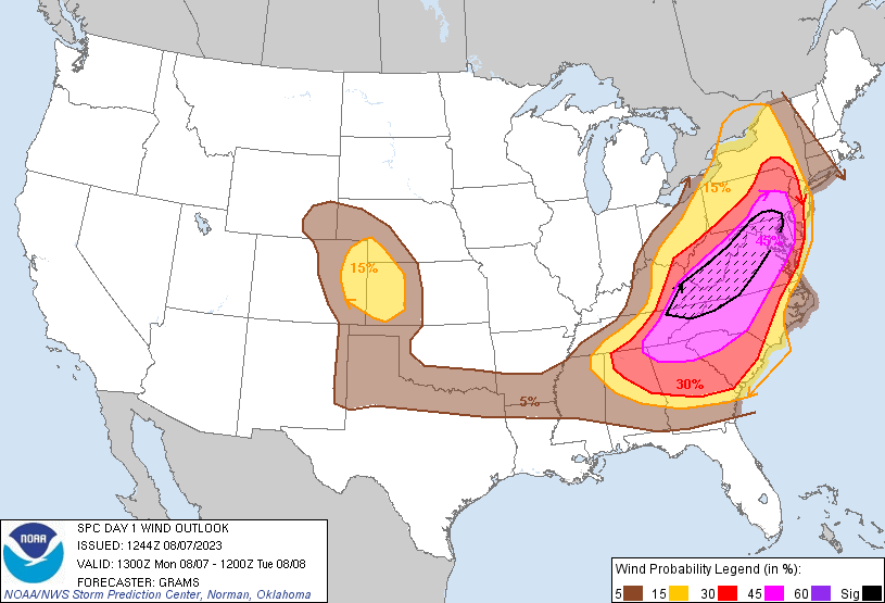
60% probs for 2 or more tornados (Mod), 30% probs of 1 or more strong tornado- 2,785 replies
-
- 1
-
-
- severe
- thunderstorms
- (and 3 more)
-
2023 Mid-Atlantic Severe Wx Thread (General Discussion)
Newman replied to Kmlwx's topic in Mid Atlantic
The SPC MCD clearly says that the wind profiles should improve into the mid-atlantic over the next few hours in response of the rapidly approaching strong upper level and soon-to-form low level jet streak. Tornadoes are definitely a threat, though clearly wind is the biggest and everyone should know that.- 2,785 replies
-
- 11
-
-

-
- severe
- thunderstorms
- (and 3 more)
-
One of the most intense severe weather days predicted in like 10 years. Wish I was back east to experience it. Y'all are in for some wild weather today. Enjoy it and stay safe
-
.gif.c1606da9f75842991e33d965d9857c99.gif)