Newman
-
Posts
2,096 -
Joined
-
Last visited
Content Type
Profiles
Blogs
Forums
American Weather
Media Demo
Store
Gallery
Everything posted by Newman
-

E PA/NJ/DE Winter 2022-2023 OBS Thread
Newman replied to Ralph Wiggum's topic in Philadelphia Region
From Mount Holly This changes as we go to the end of the week. While there are timing and placement differences with the long term guidance, all of the long term models are indicating the potential for a coastal storm to affect the east coast Thursday into Friday. Each have a coastal storm developing to our south, before a disturbance moves in from the west, bringing colder air with it to the area, and strengthening the low as it approaches. This is a week away, so there is plenty of uncertainty, so for now we will stay close to the NBM for the forecast. -
E PA/NJ/DE Winter 2022-2023 OBS Thread
Newman replied to Ralph Wiggum's topic in Philadelphia Region
I've always been a HECS or bust type of person when the ingredients are all on the table. A sneaky 2-4" event two days before? Definitely welcomed. A big dog being progged days to weeks out? Yep, give me the big thing. I will of course take anything for a White Christmas, but I will be chasing this thing for big one potential -
E PA/NJ/DE Winter 2022-2023 OBS Thread
Newman replied to Ralph Wiggum's topic in Philadelphia Region
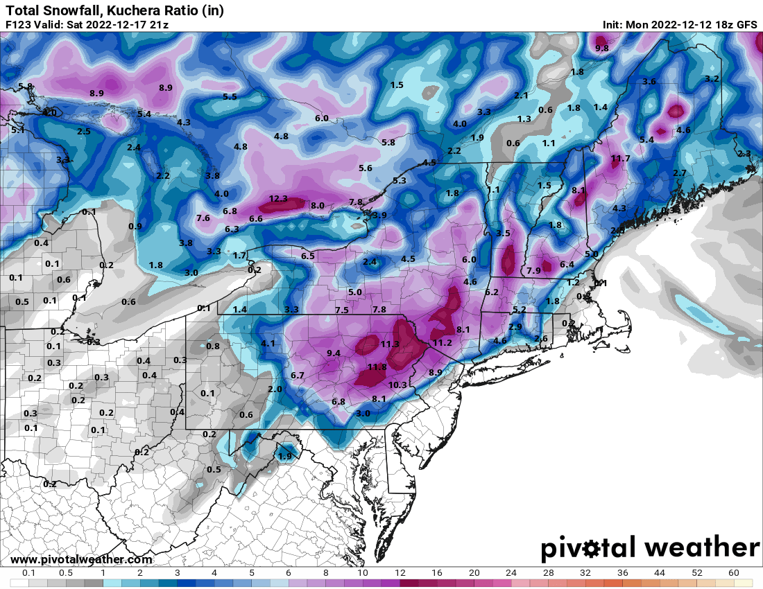
Agree, the timing was off and we still got widespread 6+". The ceiling is without a doubt 12"+ widespread, but guidance showing warning level snows even with the pieces sloppy is encouraging -
E PA/NJ/DE Winter 2022-2023 OBS Thread
Newman replied to Ralph Wiggum's topic in Philadelphia Region
Happy Hour GFS with a nuke! -
E PA/NJ/DE Winter 2022-2023 OBS Thread
Newman replied to Ralph Wiggum's topic in Philadelphia Region
-
Snowing again, mid-level warm layer is crashing and can see mix line moving back south on correlation coefficient.
-
E PA/NJ/DE Winter 2022-2023 OBS Thread
Newman replied to Ralph Wiggum's topic in Philadelphia Region
-
E PA/NJ/DE Winter 2022-2023 OBS Thread
Newman replied to Ralph Wiggum's topic in Philadelphia Region
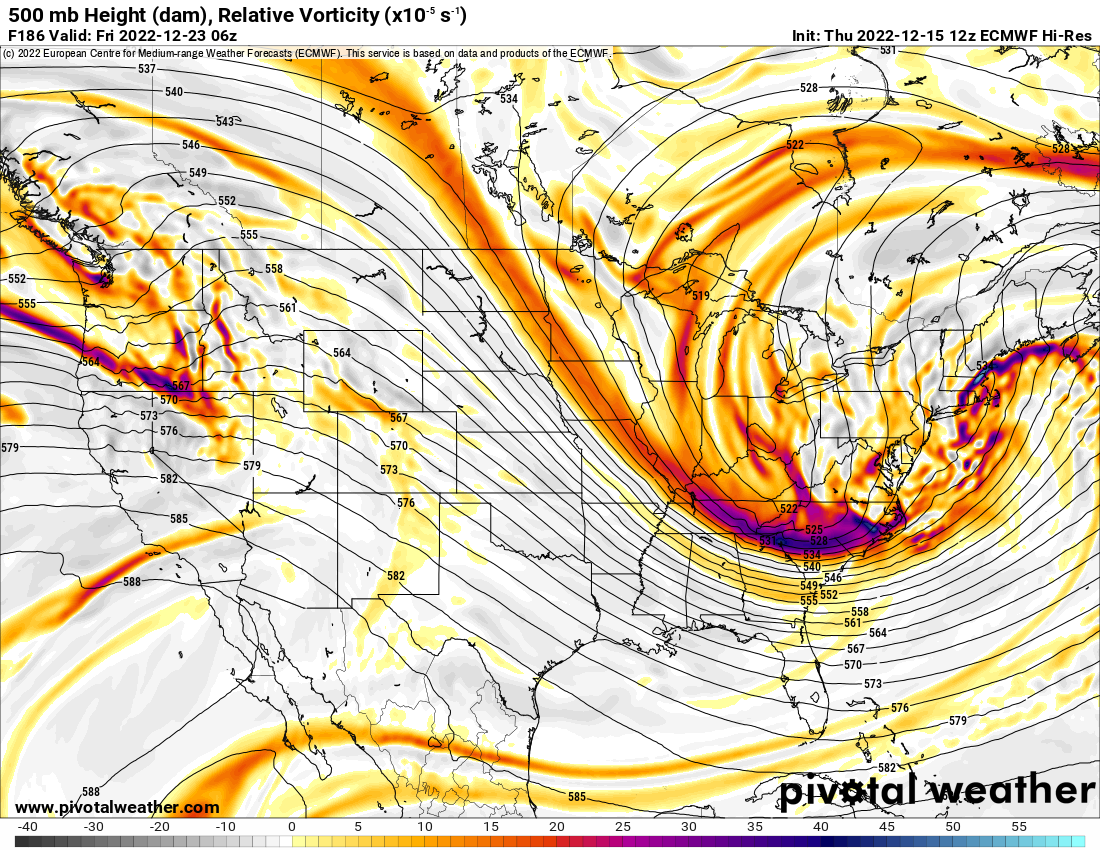
Euro is soooo close. Verbatim still gives the entire area light snows, but we're talking miles and it could've been another bomb. This 500 look is out of the NESIS textbook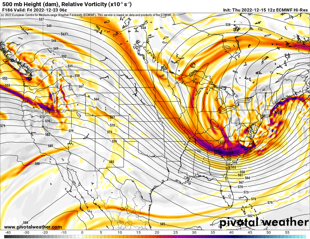
-
Central PA Winter 2022/2023
Newman replied to Blizzard of 93's topic in Upstate New York/Pennsylvania
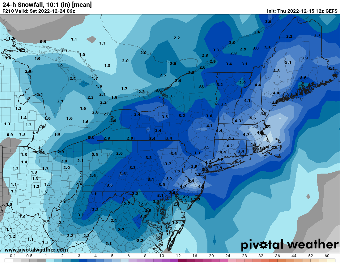
Current mean on the GEFS for the 23rd system is very impressive being 8 days out. Some huge hits, and the miss right now would be a SE scraper, not NW and a cutter.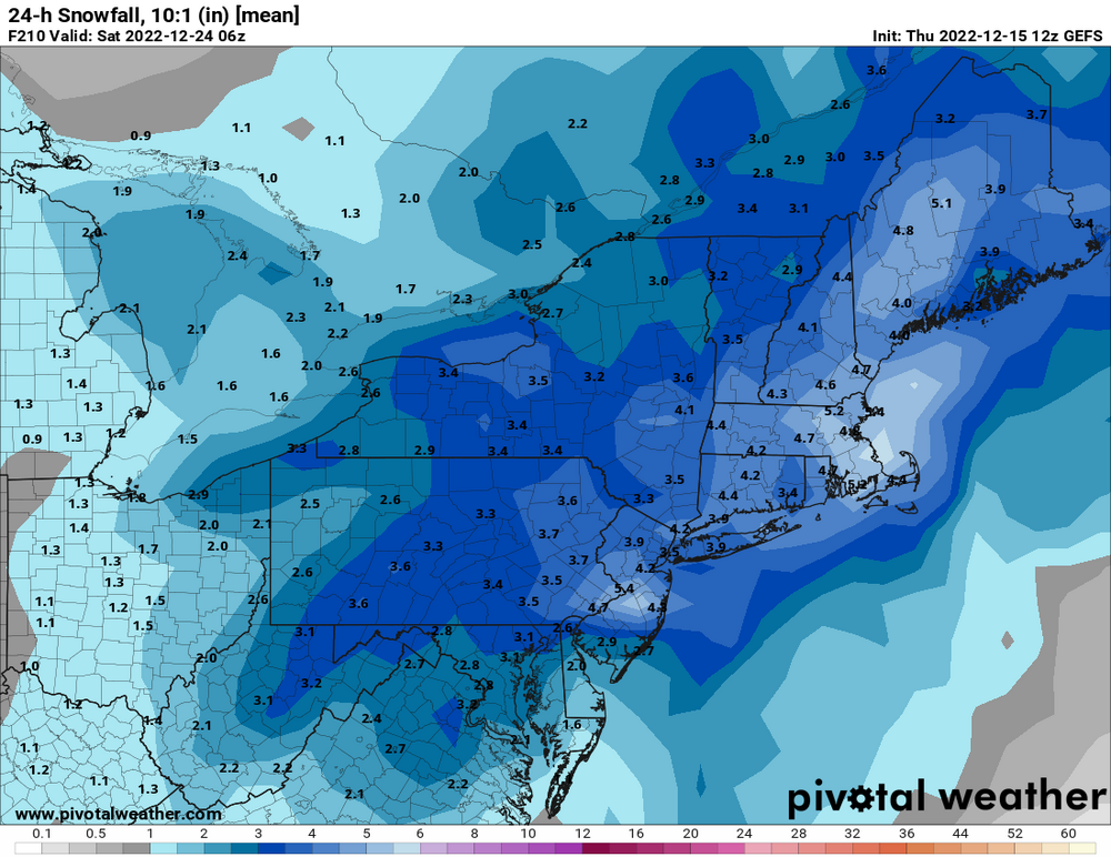
-
E PA/NJ/DE Winter 2022-2023 OBS Thread
Newman replied to Ralph Wiggum's topic in Philadelphia Region
There are some huge indi GEFS members this run. Some faster on the 23rd, some slower on the 24th. Multiple hits, and the lean right now would be a SE scraper, not NW and a cutter. The mean 8 days out is an advisory, borderline warning level, snowstorm
-
E PA/NJ/DE Winter 2022-2023 OBS Thread
Newman replied to Ralph Wiggum's topic in Philadelphia Region
Christmas Day wind chills -
E PA/NJ/DE Winter 2022-2023 OBS Thread
Newman replied to Ralph Wiggum's topic in Philadelphia Region
Closed low opens up and just squeaks by to our SE that it's mainly a coastal bomb. It was so close to being a widespread MECS -
E PA/NJ/DE Winter 2022-2023 OBS Thread
Newman replied to Ralph Wiggum's topic in Philadelphia Region
GFS with a bomb incoming -
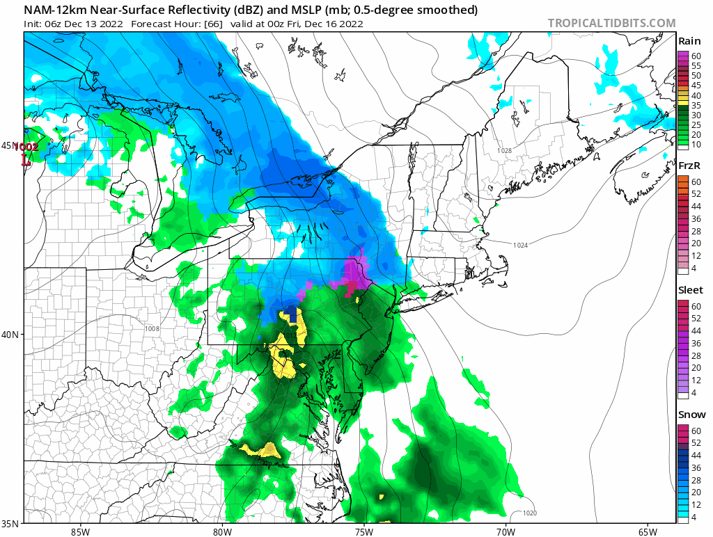
Sleet mixing back in, temp has dropped to 30 with the onset of precip. Can see mix line on correlation coefficient radar very well
-
HUGE snowflakes coming down now, mostly snow. Some flakes the size of my palm, no joke. Like almost 2" in diameter
-
Just sleet here in Fleetwood, coming down nicely though and streets covered. 32F
-
E PA/NJ/DE Winter 2022-2023 OBS Thread
Newman replied to Ralph Wiggum's topic in Philadelphia Region
The CMC was a hair away from a bomb as well, verbatim destroys New England. It's an explosive setup with that northern stream shortwave and favorable confluence/blocking. -
E PA/NJ/DE Winter 2022-2023 OBS Thread
Newman replied to Ralph Wiggum's topic in Philadelphia Region
I think it's obvious that the snow maps just aren't gonna work in a system like this, there's gonna be lots of ptype changes as rates change and such. The GFS being colder is inherently apart of it's bias to be progressive and less amped... it's just not showing as much mid-level warming as say the NAM and RGEM (which have a bias to be too amped). I honestly don't know what to expect here in Berks. I'm at a higher elevation compared to the southern part of the county which will help. -
E PA/NJ/DE Winter 2022-2023 OBS Thread
Newman replied to Ralph Wiggum's topic in Philadelphia Region
0z GFS came in even colder again. Even if we compare the snow depth maps, there's a clear shift southward. -
Central PA Winter 2022/2023
Newman replied to Blizzard of 93's topic in Upstate New York/Pennsylvania
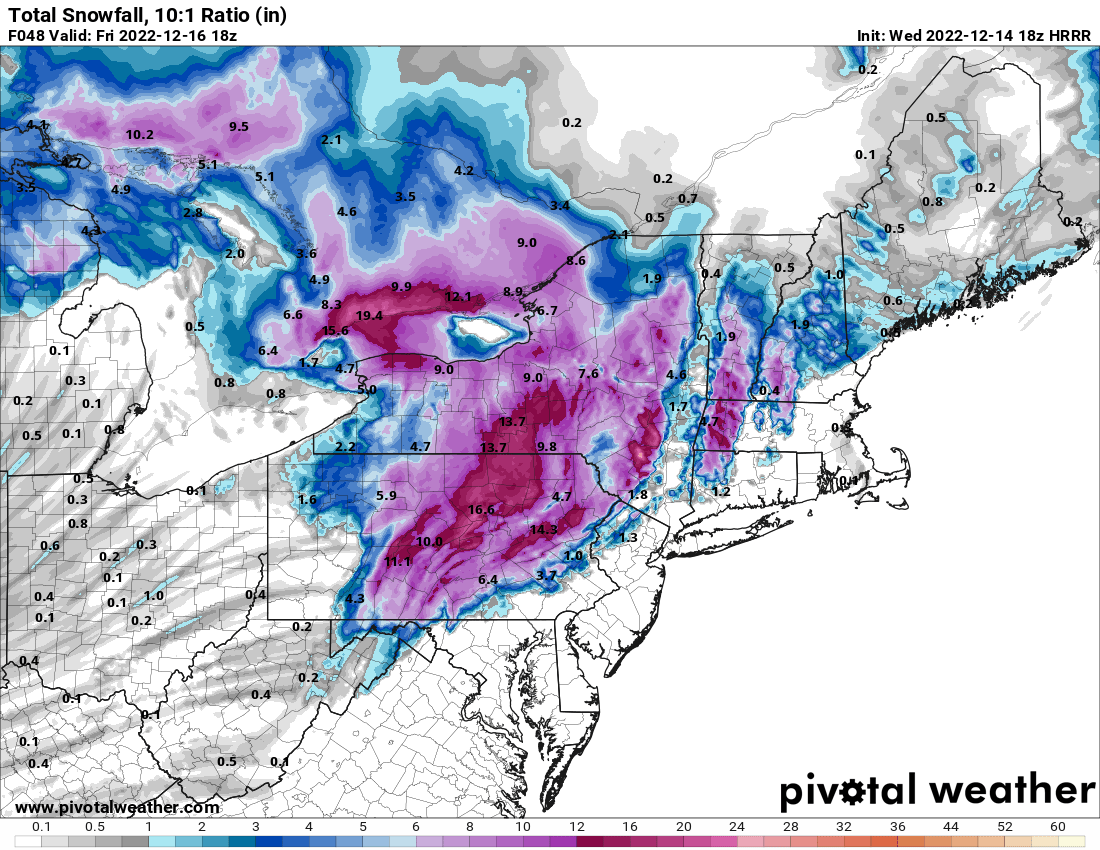
18z HRRR. Don't take the 10:1 snow map literally, instead see it as where the line for where predominately frozen precip will fall vs not. The HRRR is MUCH more generous and cooler aloft compared to the NAM. The NAM drives a warm nose aloft into the region while the HRRR is very stubborn to keep it tamed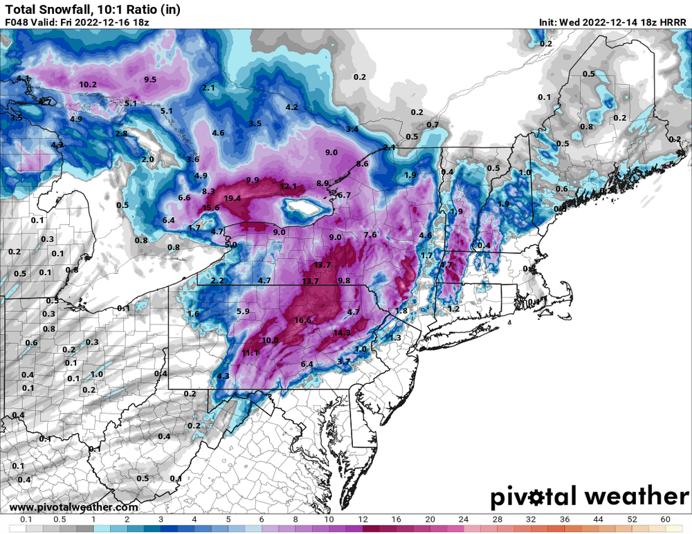
-
E PA/NJ/DE Winter 2022-2023 OBS Thread
Newman replied to Ralph Wiggum's topic in Philadelphia Region
NAM is much snowier for northern parts of the Lehigh Valley and Poconos -
E PA/NJ/DE Winter 2022-2023 OBS Thread
Newman replied to Ralph Wiggum's topic in Philadelphia Region

-
E PA/NJ/DE Winter 2022-2023 OBS Thread
Newman replied to Ralph Wiggum's topic in Philadelphia Region
I could see Berks, Lehigh, and Northampton counties starting as sleet, then as the column moistens and cools briefly thumping 1-2" of snow. Then as the mid-levels warm we'll switch to sleet and freezing rain before turning to rain. Carbon and Monroe counties will stay snow longer and those further south in Montgomery, Bucks, etc. will likely start as sleet and then go straight to rain. One thing to take note of is if the CAD can hold on longer and prevail. I don't think we're far enough out anymore for major changes. But for areas like the Lehigh Valley, an extra hour or two of sleet/freezing rain is possible than expected if it stays colder. -
E PA/NJ/DE Winter 2022-2023 OBS Thread
Newman replied to Ralph Wiggum's topic in Philadelphia Region
18z GFS with a solid thump for the LHV Thursday, some areas stay all snow or frozen.
-
E PA/NJ/DE Winter 2022-2023 OBS Thread
Newman replied to Ralph Wiggum's topic in Philadelphia Region
It's super exciting that we should be entering a loaded pattern with our first storm threat centered right around Christmas. I'm rooting for a Dec 24-25 snowstorm.