

Newman
-
Posts
2,112 -
Joined
-
Last visited
Content Type
Profiles
Blogs
Forums
American Weather
Media Demo
Store
Gallery
Posts posted by Newman
-
-
Euro with a D5-6 threat and a D8-9 threat. Far interior favored for the first verbatim, coastal regions the second storm. Places in the middle (like Berks, Lancaster, etc) kinda get skunked.
-
 1
1
-
-
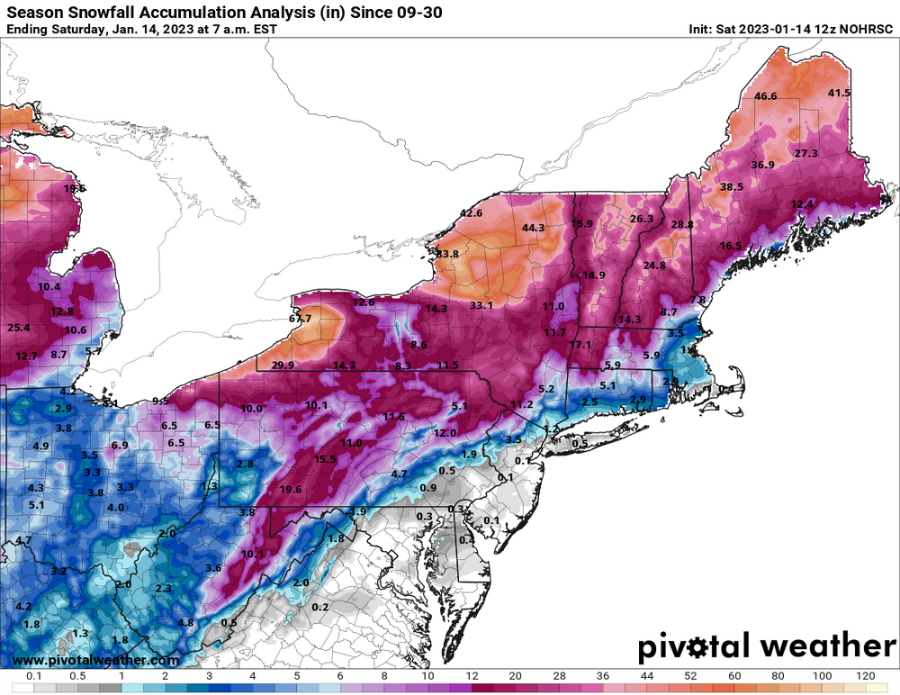
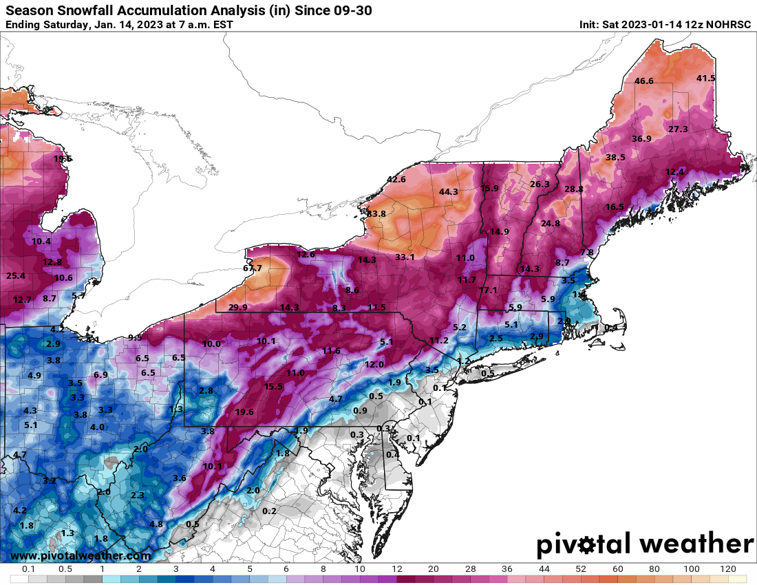
Regional snowfall update, not much
-
1
-
-
2 hours ago, Blue Dream said:
Thanks for the optimism Ralph...this winter reminds me of 2019-2020 so far. Hopefully we can half a decent storm at some point.
I think I ended with 7" 2019-2020. This winter I'm only at 1.8 so far, and that's from 4 or 5 total "storms" lol. A nice 2 or 3 inch storm would be nice at this point.
-
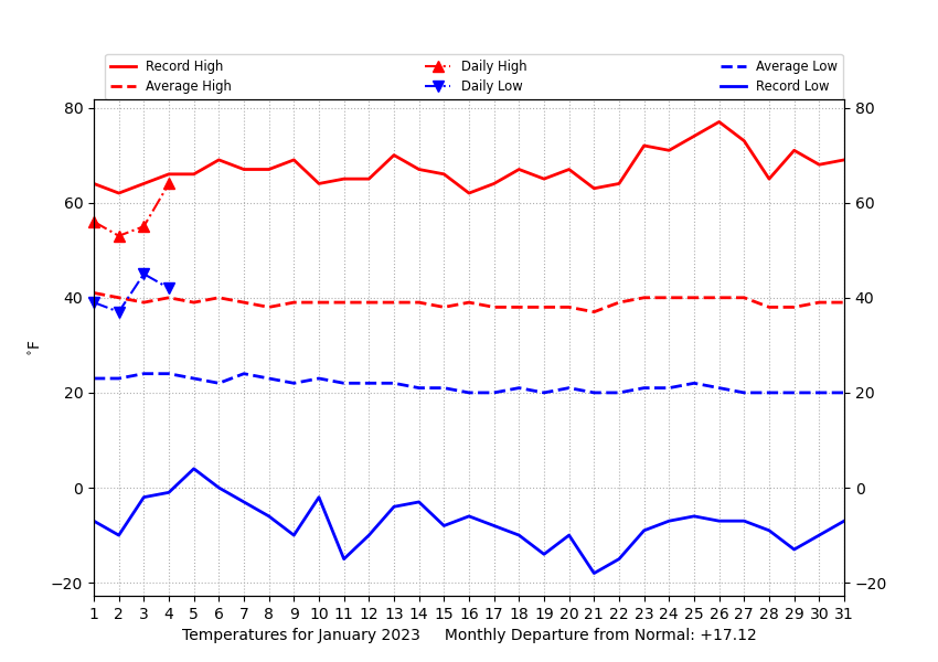
Temp departures are crazy to start this month. Philly at +17, Allentown and Reading at +15/+16 and Mount Pocono at +23! Had a midnight high of 59 degrees here, only made it to 58 this afternoon
-
 1
1
-
-
Just your typical +17 temp departure at Millersville to start the month (today's data not included). Hoping for the Jan 13-15 threat to work out!
-
Currently 61, dewpoint of 57. Feels like a warm summer morning.
-
GFS with a light event this weekend


-
 1
1
-
 1
1
-
-
28 minutes ago, ag3 said:
Probably even worse when there is only a trace through January 10th, like there will be this year.In a La Nina year with a tendency for SE ridge/western trough no less. The background state has been set for years now, it seems we need to get lucky for a +PNA and -EPO pattern with high lat blocking. It can happen, but is becoming less and less frequent it seems at least.
-
1
-
-
Can't confirm if this is real or fake, but it appears posted from a reputable source
-
1
-
1
-
-
3.2F here now in Fleetwood. There's a weather station atop the Mount Penn Memorial Fire Tower in Reading that sits 120 feet above the ground currently reporting -0.1 degrees
-
-
Mid-60s for New Years Day anyone?

-
1
-
-
Just cracked single digits, 9F
-
1
-
-
HRRR thinks I'm getting close to, or even touching 0 by 10pm tonight
-
2
-
-
12F, winds are blowin, it's nippy out there
-
Yeah flash freeze is no big deal here, only thing to worry about is a rogue wind gust knocking power out
-
3
-
-
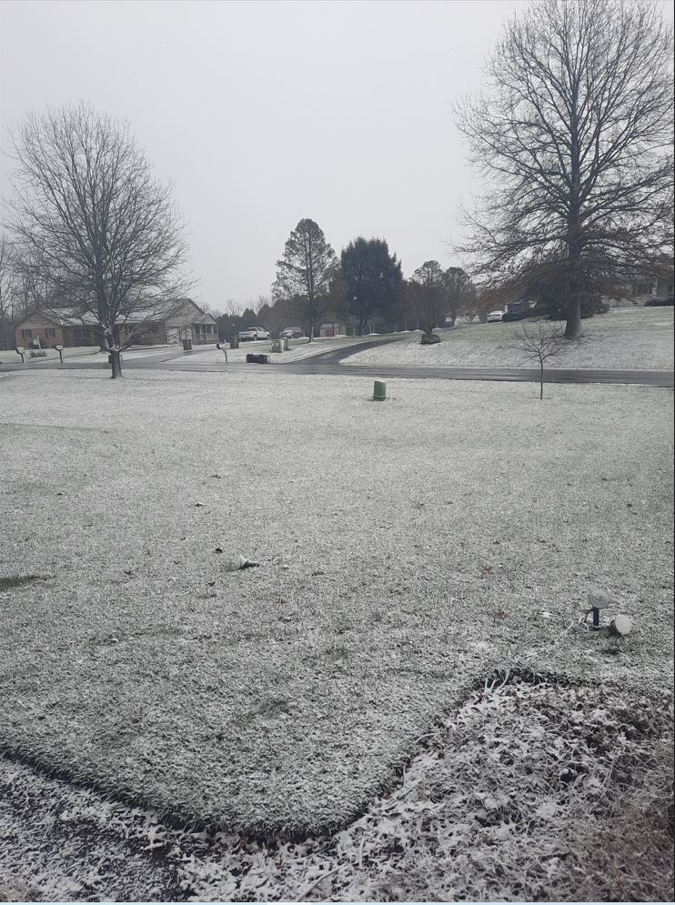
One last burst of mod snow now but can see the sun peeking through, 23F. Impossible to know how much fell with the blowing but it definitely looks like around a half inch
-
-
24F and snow has all but finished, a solid coating on the grass and cars. Roads look wet, I'll go check on the status of them here when I grab the trash can that flew into the neighbors yard
-
Temp has dropped all the way to 32 now with the snow. Mod snow and blowing. Only stickage on grass
-
@penndotguy You snowing down there in Reading yet?
-
Snowing here mixed with rain. 36F and dropping
-
1 minute ago, LVblizzard said:
Some backbuilding going on in eastern MD and SE PA. Wouldn’t be surprised to squeeze out an inch or two in the Lehigh Valley. Still raining here but that R/S line looks like it’s racing east.
You can see the wave riding up north on radar well, I too think I can get a half inch to inch here
-
Seeing the wind chill advisories issued for South Florida is hilarious... "Very cold wind chills of 30 to 35F". Kidding aside, that's pretty cold for that region. Still 42 here
-
 2
2
-

Central PA Winter 2022/2023
in Upstate New York/Pennsylvania
Posted