Scarlet Pimpernel
-
Posts
7,803 -
Joined
-
Last visited
Content Type
Profiles
Blogs
Forums
American Weather
Media Demo
Store
Gallery
Everything posted by Scarlet Pimpernel
-
Well, I can do without 80s in March (though won't be the least bit surprised if we hit that at some point then)! We go well above 80 (or 90!) plenty of times each year already! But I'm with you, would be nice to score at least one really good warning-level event this season. Personally, I'd also like to see a modest March snow as well. And I'd like to see February into the first part of March remain generally BN. Agree as well! I know several in here are bummed that we got a ton of sleet from our one major event (rather than all snow) and feel it's all been a waste somehow. But I've liked the amazingly consistent cold and snow cover that literally has not diminished in 2 full weeks now due to that cold (and the layer of solid ice on top). I can literally walk on top of the ice layer and it's as if I'm walking on regular pavement (though more slippery, of course!), without sinking into it. It's actually rather easy to walk on.
-
 The pendulum continues!
-
Just from my cursory look at both, it looks more Miller A-like to me. Primary low forms in the southeast and runs along the coast. Your typical Miller B would run a primary into TN/KY, and then a secondary forms off OBX or there about that takes over (in our more ideal situations for snow here from Miller Bs).
-
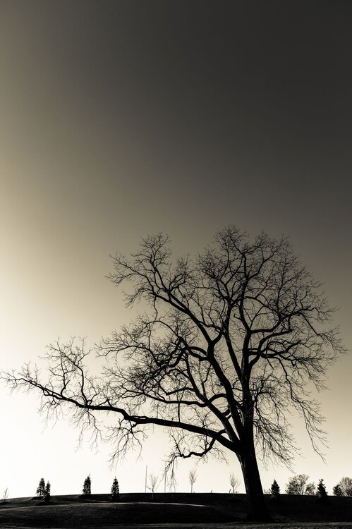
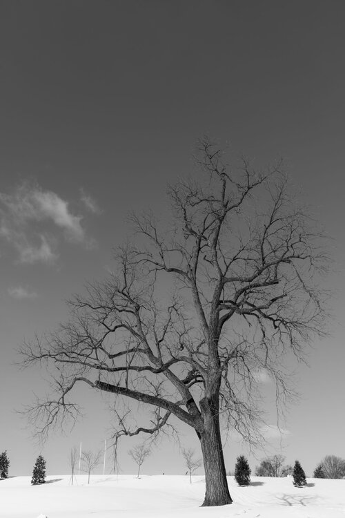
Yeah...and that tree just stands out by itself too. I will say, it was not the easiest to get a shot of. I had to work hard the first time I tried to avoid getting the brick wall along the side, the road, power lines, distant buildings farther up the Pike, and the driveway into the school in the shot. And still capture the entire tree (wide angle lens definitely needed!). I just wanted that tree with the background smaller trees and a bit of the grass in the foreground. Once I found a spot, it was easier to do the next times I went to get a photo. I'll offer this advice, if I may (such as it is!)...there's a telephone pole across from the tree (other side of the driveway entrance). I've found that standing propped up against that enabled me to avoid the other distracting elements I mentioned above.
-
Dafuq just happened in here?!?!
-
Many thanks! I live not that far from there so I've passed that school along Rockville Pike and have seen that tree many times. Always wanted to get some shots of it over the years...and finally a couple of years ago I made a point to do so. Have gotten a few photos of it since then, mainly in winter (the sparseness of the branches and how it stands out are more stunning, I think, with no leaves). Interesting side-note about that: I think sometime a year or so ago that one large branch at the bottom got cut off due to a bad storm. It actually used to extend farther out to the left side. Here's what I got (if I may) from almost exactly 3 years ago (Feb. 2023)...I actually like this shot that I took of the tree the most, using a creamy sort of black/white. It was taken later in the day (plus no snow on the ground then, grrr!), and it has that larger branch extending to the left. I like how it just stands out more, like a silhouette.
-
I believe that is an official index, like the NAO/AO/PNA/WPO/MJO!!
-
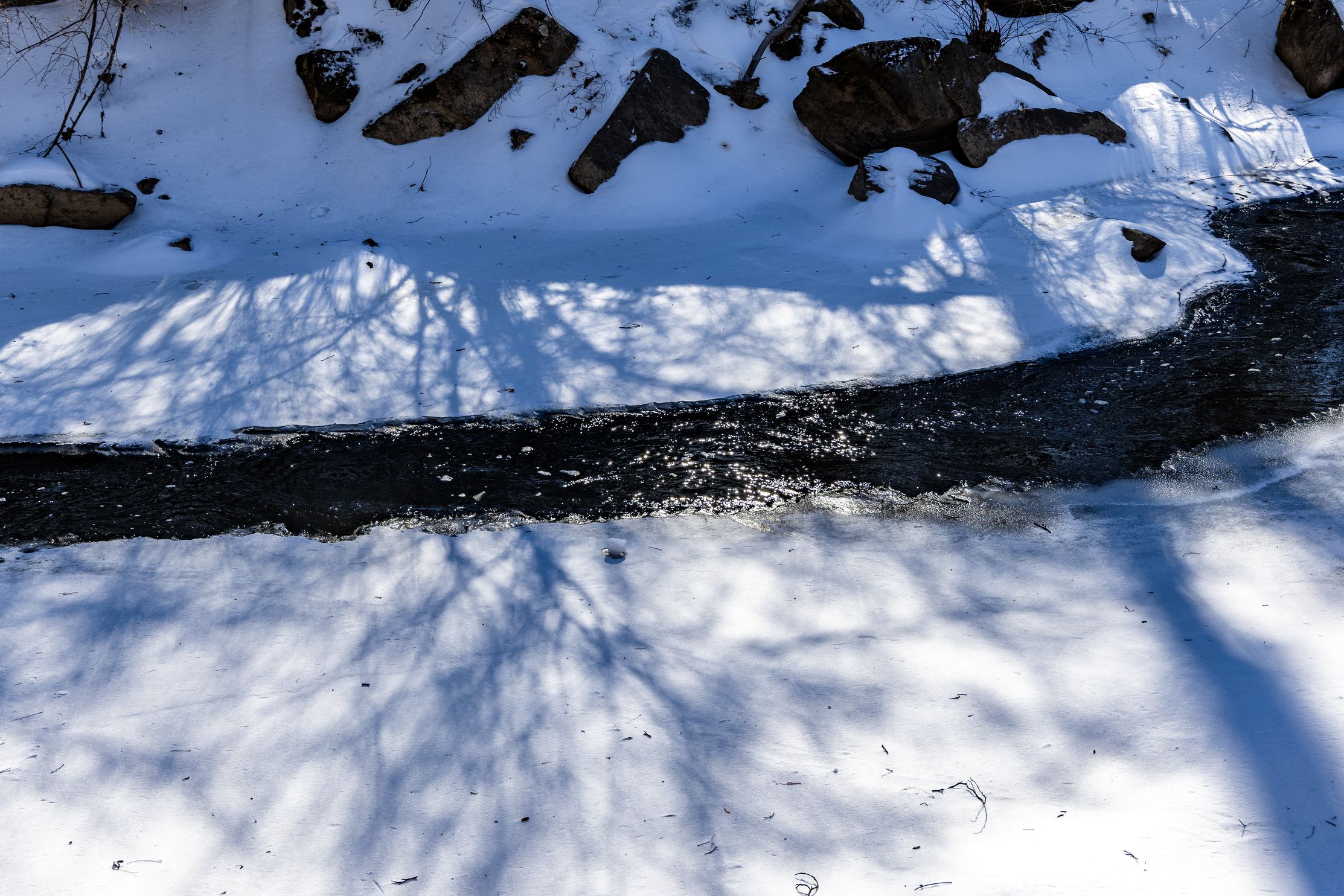
On a lighter note in here...took these shots yesterday. Yes, I went out in those conditions to do a little photography!! First one is of a nearly completely frozen Rock Creek here in suburban MD (Rock Creek Trail, near Bethesda/Silver Spring). Second one is a tree at the entrance of the Georgetown Prep school, I have always liked that tree, it's very stately-looking (black and white image)...

-
Yeah, I was going to post this the other day but I appreciate this thread. General discussion on what the overall pattern looks like, and how/if some threat could actually materialize. Without the whining, etc., with every model run. I take it that if an actual event threat materializes, that will be discussed more in the regular medium range (and potentially eventual storm specific thread). OK, on topic: It does appear that next weekend's possibility is looking pretty slim right now. I know most guidance has been advertising a general warmup sometime just after next weekend, but it's unclear (to me) how entrenched that gets. I've only followed the guidance (500-mb mainly) in a cursory way, trying to see how things evolve as we get into the last week or so of this month. It seems to me that the warmup doesn't look "extreme" and we kind of end up after that in a sort of changeable look with potential favorable situations for some decent snow chances. I am still hopeful from various things I've seen in here (various indices, extended Euro guidance, etc.) that we're not done yet. I still believe that we don't escape February with zero snow; not a HECS system, but I think a SECS to a MECS level event surely must be on the table. Similarly for the first part of March.
-
Agree. Fact is, potential is there not just for next weekend but some period beyond that as well. It doesn't appear to be wall to wall shit the blinds. (Oh no, I posted medium range discussion in the Banter thread rather than banter in the Medium Range thread!!! LOL!! )
-
FYP a little!! I swear, the freak out "OMG, I lost 8" snow since the last run, we suck, it's done!"
-
-
Did we find another Rev War Re-enactor??? What the Hessian is going on???
-
Very much so, agreed! Would take that in a minute!
-
Could it be...FOLKSY, even?? Of course, 200 hours out, whatever, but I am just glad to see a semi-consistent possibility across all model guidance right now. Euro also looked good at 12Z for the most part.
-
I think you're fine, probably no need to apologize. Everyone here respects your analysis. Even if you're making less than $150K hahaha! You always appropriately correct or re-state things when required. Besides, at this time range those smaller details like NS shortwaves and such are going to move around every cycle. Key takeaway is there is a solid signal for us in that time period, seems like one or two waves in there that could work?
-
Decent light snow has been falling for about the past hour or so. Small flake size.
-
Wow...that's not a very nice thing for Jack to do at your place!!
-
Bravo! Well played!
-
Yeah that did look..."interesting"...in terms of development. But hell, looked pretty damned decent to me overall! it appears that it develops a coastal after it has passed us (and dumps a decent WAA thump of snow/mix/ice), while still holding on to a fairly strong primary around the Lakes. But temps look OK verbatim through that time. And then some small disturbance gives more snow a short time after behind all that it appears?
-
Just be sure to wear your rubbers...I mean BOOTS of course!!!!
-
Sorry if I came off a bit harsh before. I'm hopeful that whatever warmup or relaxation is relatively short and we can have some real chances thereafter for the latter part of this month and early March. I'm not expecting the level of cold we just had (nobody should be!), but if we can have some decent cold around that can be tapped into with a nicely timed wave, we can do pretty well perhaps. @psuhoffman described this a bit earlier. We may have more variability, but as long as we don't get stuck in a lousy setup I think/hope we'll be good.
-
But you're only showing it THROUGH NEXT FRIDAY when it will just be underway, and it includes some very cold air expected this weekend. Look, I'm all for it being very muted as much as possible but in reality we should be looking at about Wednesday of next week into the following one. ETA: And yeah, even looking at the plot @Ji posted which would cover more of the moderation...note the warm departures heading our way just to the west. ETA2: Also, every single model, not just the Euro, is projecting a blast of very cold air through this weekend into the early part of next week.