MAG5035
-
Posts
5,882 -
Joined
-
Last visited
Content Type
Profiles
Blogs
Forums
American Weather
Media Demo
Store
Gallery
Everything posted by MAG5035
-
Fall/Early Winter 2019 Forecasts and Discussion
MAG5035 replied to pasnownut's topic in Upstate New York/Pennsylvania
Intellicast is a fairly decent regional radar to use that also doesn't do too bad with p-type depiction either, but yea York/Lancaster county is a tough spot in PA for doppler products as LWX or CCX only sees down to about 6-7K feet at best on the 0.5º tilt. Considering the Sus Valley is one of the more severe prone parts of the state and with the population you would think a doppler placed somewhere around there would be of interest. I say put one in Tamaqua. Between CCX, BGM, and DIX... Voyager can't see under 9-10k feet with any of them. -
Fall/Early Winter 2019 Forecasts and Discussion
MAG5035 replied to pasnownut's topic in Upstate New York/Pennsylvania
I was just about to post about that, they have I-80 closed the whole way back to Lock Haven (Exit 178) from Exit 212. -
Fall/Early Winter 2019 Forecasts and Discussion
MAG5035 replied to pasnownut's topic in Upstate New York/Pennsylvania
Nice squall arrived, visibility 1/8 to 1/4 and roads caving. Looks like at least another decent one coming behind this one. -
Fall/Early Winter 2019 Forecasts and Discussion
MAG5035 replied to pasnownut's topic in Upstate New York/Pennsylvania
Geez that looks like at least 2”. I have about a half inch so far today. Radar looks good to get into some of what just went through you fairly soon. -
Fall/Early Winter 2019 Forecasts and Discussion
MAG5035 replied to pasnownut's topic in Upstate New York/Pennsylvania
I'll be the first to admit that I'm bummed out that we haven't capitalized the way we could have on a very active opening 17 days of December, but we have already had a better December overall than last December as we were pretty much shut out with a less workable pattern. At least this December has taken some swings, that major storm to open up the month was very close to being a big one, just missing the region with big snows and most of us still saw something from it. And then of course, yesterdays system. I'm sure some folks are getting antsy and whatnot but expectations seem higher than usual this year given the fact that I know it seemed like every winter forecast I've come across shared on social media during the fall or even the Farmers Almanac of all things were promising big things from the winter pattern. Buying in to all that of course is always a recipe for disappointment for at least somebody. Long range forecasting for general tendencies over a coming season can be difficult enough to predict much less anything specific, especially coming into a winter with no real dominant signal (the neutral ENSO for example). We're not even a full month into meteorological winter yet (which doesn't include March) either, and we worked into a winter-like pattern quite early all the way back in early-mid November. I don't always like the super early winter pattern like that because it's hard to capitalize in the snow department in November and it usually sets up for some kind of a change/breakdown sometime in December. I'm not worried right now going forward. It's important to remember that even our big time winters we hold near and dear normally have some rough patches in them. We're going to get a break in things in the 4-7 days that includes Christmas in the middle and no, it's probably not going to be 75ºF Xmas Eve. The pattern may not look great at the moment but I also view it as continuing to be quite changeable and not necessarily locked into anything good or bad. This moderating trend we're looking at for the holiday appears to be a split flow regime with emphasis on the split, with a progressive northern branch way too far north and no amplification to interact with the southern stream. The most dominant teleconnection I've seen appears to be the AO, which has been running positive. +AO's keep arctic air tighter to the pole which can be a reasonable explanation for perhaps why we've generally been seasonally cold at best and have had only brief colder shots this month. That is currently progged to trend negative as we get to the end of the month. -
Fall/Early Winter 2019 Forecasts and Discussion
MAG5035 replied to pasnownut's topic in Upstate New York/Pennsylvania
C'mon back edge, I see you out there between here and Pittsburgh haha. Miserable night, basically an all freezing rain affair and temps remaining right near the 32ºF mark. I'm glad I salted the driveway this afternoon. Probably a tenth or so in the trees/railings/etc. The lack of a high pressure to the north shows... a decent snowfall is probably the primary impact of this system over a good part of our region with one given the track of the low. We've really wasted a lot of potential this month. -
Fall/Early Winter 2019 Forecasts and Discussion
MAG5035 replied to pasnownut's topic in Upstate New York/Pennsylvania
Trying to mix some ice pellets in here. Notable feature on CCX radar (CC product) is a pretty established snow/mix line already pretty much running on I-80 and given that and mPing obs I've not really seen anything on that product that indicates to me any collapse of that southward with the column cooling enough. The knee jerk reaction to that would be that pretty much shuts down the prospect of seeing a 2 to perhaps 4 inch thump in the central counties below I-80..or in fact any additional snow at all, which would be a pretty sizable near term bust. I'll give it a couple hours but I don't like how things set up when the established precip came in, plus the new meso models haven't had it either. Williamsport still looks ok at the moment, I'd be curious to hear any obs from there. -
Fall/Early Winter 2019 Forecasts and Discussion
MAG5035 replied to pasnownut's topic in Upstate New York/Pennsylvania
Precip has returned in the last hour and is arriving as straight freezing rain. Temp is 31ºF so untreated stuff is already glazed. The precip is also fairly light at the moment, so we'll see if the heavier stuff starts working on the column and frozen p-types mix back in. I would imagine with the long lull in precip today that the temps aloft were able to creep up some. -
Fall/Early Winter 2019 Forecasts and Discussion
MAG5035 replied to pasnownut's topic in Upstate New York/Pennsylvania
Additionally, it appears that CTP is angling toward the several hour period of frozen in the central counties that some of the meso models were hinting at earlier today and discussed in here, and the newer advisory products reflect as such. I'd be plenty happy if I ended up with 2-4 inches out of this whole event. Most of the Sus Valley I think will see frozen as well for at least the first few hours once the heavier precip gets back into the region. -
Fall/Early Winter 2019 Forecasts and Discussion
MAG5035 replied to pasnownut's topic in Upstate New York/Pennsylvania
Residing right around 31ºF and the inch of snow pretty much stuck around today. Just got the driveway salted down for whatever mess is coming tonight. Browsing the weather statement and came across this. How is this not an ice storm/winter storm warning designation for Somerset, Bedford and Fulton? Up to 0.4" of ice is a significant ice event, and their ice map illustrates a pretty widespread area of 0.25"+ in those three counties. -
Fall/Early Winter 2019 Forecasts and Discussion
MAG5035 replied to pasnownut's topic in Upstate New York/Pennsylvania
Yea obviously the TT snowmaps are quite flawed with mix scenarios, but the 12z NAM does continue to show the first few hours of the heavy precip temporarily cooling the column just a bit at the 850 and 925mb levels, and for places like State College and Harrisburg north and west that may be just enough for several hours of frozen before WAA aloft eventually does win out overnight. -
Fall/Early Winter 2019 Forecasts and Discussion
MAG5035 replied to pasnownut's topic in Upstate New York/Pennsylvania
I was just looking at that full length 12z HRRR too. Looks like I'll be riding the mix line for awhile as per usual. I'm hoping to at least maintain sleet for awhile over freezing rain as well as seeing maybe a couple more hours of snow on the front end of the main precip. That main batch of precip looks like it will be moderate to heavy, so that may hold down the column enough where it's marginal to perhaps score some more snowfall in the counties between the turnpike and I-80. 6z NAM kind of hinted at that too. -
Fall/Early Winter 2019 Forecasts and Discussion
MAG5035 replied to pasnownut's topic in Upstate New York/Pennsylvania
Right at the 1 inch mark here with the first round, at least I got that out of the way finally (first 1"+ snowfall). -
Fall/Early Winter 2019 Forecasts and Discussion
MAG5035 replied to pasnownut's topic in Upstate New York/Pennsylvania
The two pronged nature of this system is going to provide two different areas of accumulating snow. What the south central and Sus Valley see's snow-wise will heavily depend on the front running wave of precipitation, and how much into PA it reaches (as well as rates/intensity). The models have been focusing that initial wave on the southern portions of the subforum (generally below I-80) and not so much in the northern tier. The main precip associated with the surface low passage will then involve the entire region, though warm advection aloft will introduce the mixing issues to at least the southern tier. The uncertainty that remains is where the second snow swath ends up being. Models pretty firm now on the surface low coming close but passing just south of PA... so while lack of a high to the north continues to be a sticking point for me, cold air at 925mb-surface should hold fairly well for most of the event (esp north of the turnpike). 0z and 6z Euro seems to be furthest south with the second swath of snow, getting places like IPT their 2-3" of snow as that particular models hangs the 850 0ºC line right through the middle of the state. GFS seems the most "black and white" (snow and rain) and fairly warm with not a lot of ice while the NAM has more widespread icing in central PA after the initial snow. Personally I think the NAM's P-type take seems the most plausible given the scenario. This should be an overall winter weather advisory type event on both the snow and ice aspect. I think the south central counties (south of I-80, west of I-81) have the best chance of getting the 2-3" snowfall that appears to be the mostly likely decent snowfall outcome of this. I'm worried that the front running wave fizzles some as it gets into the LSV, and folks there end up with lighter rates and have trouble getting an inch or so. And then, I'm also concerned about the advection aloft getting further north and mixing most of the northern tier when they finally see the precip from the main wave.. essentially providing the same scenario as the LSV with having trouble getting say, an inch out of this. We could also end up colder aloft as well too in the end, which could possibly make for a higher end advisory event if anyone saw mostly snow from both waves, but lack of high pressure to the north is a limiting factor for that potential outcome. -
Fall/Early Winter 2019 Forecasts and Discussion
MAG5035 replied to pasnownut's topic in Upstate New York/Pennsylvania
Pretty healthy dose of pingers currently with a glaze of ice. Sure hope road crews were at least somewhat ready to deal with this stuff this morning because it could turn into a lot of problems real quick. -
Fall/Early Winter 2019 Forecasts and Discussion
MAG5035 replied to pasnownut's topic in Upstate New York/Pennsylvania
Depends on the model, the Canadian was showing a Miller B type solution on it's 12z run today. The latest 0z run has that particular model tracking somewhat northwest of 12z, running the primary surface low right up the Ohio River. Some semblance of a eventual transfer but the solution is mixy/rainy in PA after a period of accumulating snow for most of our region. Models are generally similar with storm evolution, running a decent wave originating in the Lower Mississippi Valley tracking into the Ohio Valley on the approach to our region. So yea, I guess it does look to be more of a straight up SWFE over a miller B scenario. I'm not seeing much high pressure to the north being progged so in turn I'm not seeing this potential wave getting heavily forced to transfer to the coast. For the most part the biggest difference in the models is track right now. The GFS (surprisingly) continues to be on the NW envelope of guidance, running the low into the Lower Lakes, while the new Canadian tracks as mentioned up the Ohio River to SW PA and then starts an ambiguous looking transfer to the coast. Today's 12z Euro has the same evolution but is notably SE with the low track, running it out of the Lower MS Valley towards VA and the DelMarVA coast. The Canadian shifted north tonight so we'll see what the Euro does later. Even if the NW GFS track were to verify, the setup in place should be adequate enough for some wintry issues in our region on the front end at least. It's not the greatest look ever, obviously I would like to see a stronger high in place to the north. Even the 12z Euro's favorable track with not much high pressure to the north would probably introduce p-type issues to the Lower Sus Valley. Issues aside, this thing has a good chance at being our first region-wide frozen event (even if it ends up as rain at the end). -
Fall/Early Winter 2019 Forecasts and Discussion
MAG5035 replied to pasnownut's topic in Upstate New York/Pennsylvania
Some surprise snow flying around this evening. And it's 28ºF so it's even sticking to the streets too for a change (dusting). -
Fall/Early Winter 2019 Forecasts and Discussion
MAG5035 replied to pasnownut's topic in Upstate New York/Pennsylvania
Most of the globals have generally showed this kicker system early next week behind the weekend storm. Speaking of the weekend storm, some of the central counties may see initial mixing.. if it times a bit faster (say more on Friday). Mainly this is probably going to be another wasted opportunity. Cutters like the current storm are one thing, but a Gulf Low taking a just inside the coastline track but not having the available cold air in mid-Dec is a real bummer. Strong high over New England midweek quickly retreats in the progressive pattern ahead of that system, and the lack of western ridge and a pretty positive NAO (and AO) don't do any favors either. The result being a mostly wet coastal. My obvious concern for the following system potentially in the D7 or so range is for a trend toward another cutter. The positive NAO is forecast to neutralize getting toward that timeframe and we have a bit of a better look up top overall (Canada/northern latitudes), so we'll see if that remains more workable. A very active looking pattern the next 10 days either way. I think we still have a good chance of landing something in the region before the holiday. With regards to the potential changeover tomorrow night into Wed, I'm not particularly enthused about it. I think you might need to be in the Laurel's or E and SE of MDT for the best chance of seeing any kind of actual accumulation, and even then I think the best our subforum might see is an inch or so. Most models not named the GFS seem to give the I-95 corridor more of the focus for something that could be of the advisory variety. Been starting to watch the HRRR on the major z times (0,6,12,18) that extends out to 36hr. It does bring another wave of precip up through PA later this morning, but the cold air isn't in yet. -
Fall/Early Winter 2019 Forecasts and Discussion
MAG5035 replied to pasnownut's topic in Upstate New York/Pennsylvania
Awful nice rainstorm out there today, blah. -
Fall/Early Winter 2019 Forecasts and Discussion
MAG5035 replied to pasnownut's topic in Upstate New York/Pennsylvania
I think the biggest issue the next 6-10 days is a bit of a progressive pattern and not much western ridging to be had.. keeping us vulnerable to cutters despite what looks to be a pretty decent cold shot behind the storm progged for early next week. Models are quite insistent on something fairly significant in that D8 realm. The problem is it appears the cold air is pretty well displaced from the eastern seaboard even in the 12z GFS case of having a coastal low run right up the coastline (no high in place either). There's a lot of time for that to evolve but that's where we're at with that currently. NAO realm has shifted to postive as well, after the downstream blocking was a big factor in us very nearly being more directly in what was a blockbuster snowstorm not all that far away from our subforum at the beginning of the week. Such is how it goes a lot of times this early. At the moment, I don't see anything particularly detrimental pattern wise in the longer range to say we won't have chances...but there are some limitations to consider. -
Fall/Early Winter 2019 Forecasts and Discussion
MAG5035 replied to pasnownut's topic in Upstate New York/Pennsylvania
Finally getting the ground whitened up this evening with some of the lake effect making it off the Laurel's. This could have been a 2-3" type of day here between the several hours of steady light snow this afternoon and a relatively robust NW flow LES regime but temps in the mid 30s made for nothing to show for this afternoon. Temp is still in fact 34ºF at this hour so the snow falling currently isn't affecting paved surfaces. Took the 4 mile drive up to the top of Wopsy Mountain not too long ago.. 29ºF up there with snow and blowing snow. There's easily 4-5" up there (a lot of that from Sun/Mon) plus most of the ice storm ice remaining encasing the trees almost completely in white. Insane how fast it changes in just 3-4 miles. -
Fall/Early Winter 2019 Forecasts and Discussion
MAG5035 replied to pasnownut's topic in Upstate New York/Pennsylvania
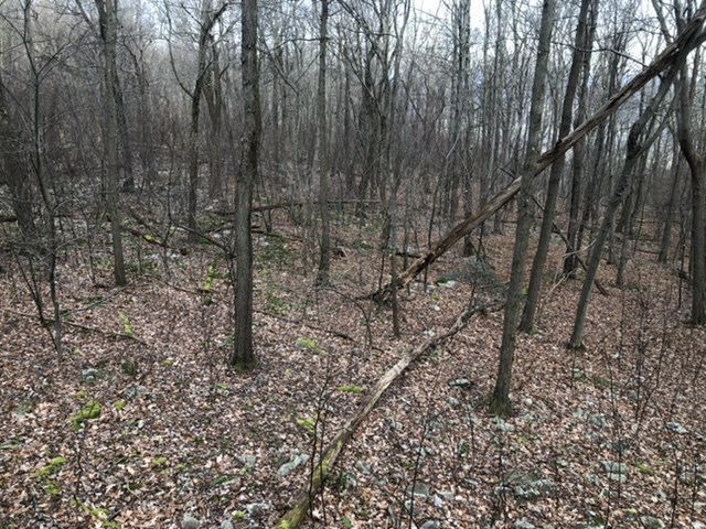
Some steadier snow moving through, although surface temps are a bit warm and nothing accumulating currently. Some of the heavier returns coming might get some accums started. Lake effect regime sets in tonight which favors the NW and Laurels. Some of you guys in the LSV are beating me in the early going with snowfall haha. Despite the snowy/icy pics from where I was hunting 20 miles away and the completely ice encased and snowcovered Allegheny front a mere 4 miles away from here.. I only got about 0.2" at the house from Sun/Mon's major storm. I logged 0.7" in November so just shy of an inch on the season total. Speaking of the ice from Sun/Mon's storm, I snapped this pic in the woods yesterday morning.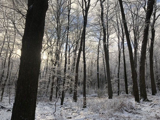
-
Fall/Early Winter 2019 Forecasts and Discussion
MAG5035 replied to pasnownut's topic in Upstate New York/Pennsylvania
Treestand ob is much different this morning than Saturday’s with a steady light snow falling and about 1.5” on the ground (with ice left over on the trees). This is Tussey ridge around 1700’ in NW Huntingdon County.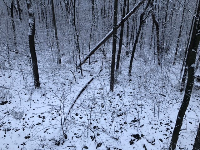
-
Fall/Early Winter 2019 Forecasts and Discussion
MAG5035 replied to pasnownut's topic in Upstate New York/Pennsylvania
Back in Altoona from camp for a few hours. The area of precip I went through coming from Huntingdon County turned to snow and there's a light accumulation back in town. Ice was relatively minor today, mainly just on the ridgetops by the afternoon. Tomorrow looks interesting. -
Fall/Early Winter 2019 Forecasts and Discussion
MAG5035 replied to pasnownut's topic in Upstate New York/Pennsylvania
Reporting from the tree stand haha I get poor cell reception down at the camp so I’m a bit limited this weekend with updates. For the wintry mix/ice portion of this storm I have my usual position on CAD staying anchored better than modelled, and really most models have been consistently icy all week to begin with. There will definitely be some impacts region wide with the worst of the ice potential in the ice storm warned counties. More sleet further east and northeast may prevent warning level ice accrual but the mix will likely make things slippery. The wildcard is the redeveloping coastal and upper level low swinging through. The biggest snow potential is in the Poconos (with the coastal) but the ULL passage could make for periods of snow getting towards Monday in C-PA. I thinking maybe 1-2” type potential with the ULL but any meso banding could spike snowfall in spots. Patchy snow could linger for awhile too