

MAG5035
-
Posts
5,882 -
Joined
-
Last visited
Content Type
Profiles
Blogs
Forums
American Weather
Media Demo
Store
Gallery
Everything posted by MAG5035
-
Central PA - Late Dec 2019/Jan 2020
MAG5035 replied to MAG5035's topic in Upstate New York/Pennsylvania
Normally I'd say a 1040+ high is money for a mostly frozen or icy event in most of C-PA, but these are pretty wound up solutions into the Lower Lakes along with the high pressure not being anchored. We need to see a weaker low or a better/early enough transfer to the coast. Obviously a further southeast track underneath us would be ideal but this one probably cuts if it ends up being a deeper system. Certainly a solid possibility of seeing decent wintry weather impacts but this will def be a flawed system/setup. We're in the midst of the transition period in that timeframe and we're not quite there yet pattern wise as still see pretty notable eastern ridging present at 500mb with this storm arriving. So the big keys will be strength and positioning of the Canadian high for the system arriving, and how much the cold presses into the area later this week prior to the event. If you don't press that boundary far enough south we could end up with an event that's more wet than wintry. -
Central PA - Late Dec 2019/Jan 2020
MAG5035 replied to MAG5035's topic in Upstate New York/Pennsylvania
Def a strong signal for the event around the 19th-20th, as it's been pretty prominent on the models the last few days. Quite a strong high to the north being progged, which is a change from most of the events we've been presented with so far this winter and if that feature remains a player on ensuing runs we will likely be tracking a winter storm with potentially wide ranging impacts for our area this week as we bring in some fresh cold just prior and set in place that high pressure. The pattern going forward for the second half of the month is rapidly looking much, much better. We're currently working a very high amplitude phase 4/5 MJO but I've noticed in forecasts the last several days that this MJO pulse has been progressing rapidly out of the bad range (4-6) and it is starting to carry amplitude into more favorable phases on some of the model forecasts. We could find eventually that this ends up carrying into 8-1-2, which could potentially help the NAO realm if that were to come to fruition. We see lessening of the +AO over the pole and a stunning reversal of the PNA (which our next potential winter storm is right in the middle of) in the forecasts as well. Considering this winter as a whole so far, we're really right around where we were at this time last winter minus the November snowstorm.. complete with cancelling January during the last week of December and all. Intriguing that the fabled decade that the ice age was coming back (the 1970s) has only one less 68º+ meteorological winter day than this past decade. -
Central PA - Late Dec 2019/Jan 2020
MAG5035 replied to MAG5035's topic in Upstate New York/Pennsylvania
6z NAM for the win this morning haha. I mentioned first thing this morning that the NAM with the Cobb method had a stripe of 6”+ running the far southern tier... indicating better than 10:1 ratios as that method incorporates ratios in the snow growth zones in the column. 700mb forcing was likely pretty good and we had a cold column. The rates were enough to overcome initially marginal surface temps and realize most of the accum potential via ratios. I’d be curious what those 4-6” amounts melt down to. -
Central PA - Late Dec 2019/Jan 2020
MAG5035 replied to MAG5035's topic in Upstate New York/Pennsylvania
2.0" was the final here.. I'm glad things came back up enough to see something half decent. Next up is the potential for snow squalls in the central counties tomorrow. -
Central PA - Late Dec 2019/Jan 2020
MAG5035 replied to MAG5035's topic in Upstate New York/Pennsylvania
1.7” with moderate to heavy rates. Pretty wet snow with roads slushy or snow covered.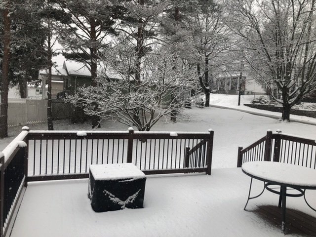
-
Central PA - Late Dec 2019/Jan 2020
MAG5035 replied to MAG5035's topic in Upstate New York/Pennsylvania
Overnight models have bumped back north with precip, getting a good majority of the subforum into snow today.. even up to IPT. Here's one of the 6z NAM snowmaps. It may be one of those positive snow depth algorithms. The Cobb method, which I believe is the one that incorporates the actual snow growth region with it's ratio calculation has a stripe of 6"+ running the mason-dixon line. That's an indication that aloft, the column is cold enough to support better than 10:1. The ground truth will probably be tempered a bit though with initially marginal surface temps. A quick snowfall but if we get some fairly robust rates I wouldn't be surprised to see 3 or 4 inches in spots along the southern tier. Here's to some + snow before the mess and warm weather at the end of the week.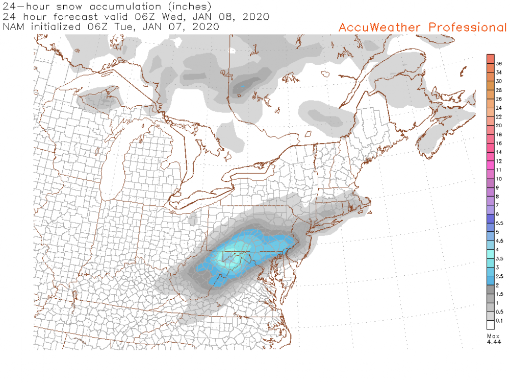
-
Central PA - Late Dec 2019/Jan 2020
MAG5035 replied to MAG5035's topic in Upstate New York/Pennsylvania
I'll get on the GFS and HuRRR train, as that model's been pretty well north with the precip as well since we've gotten into HRRR range. Otherwise this system's getting just close enough for me to see someone like Cashtown probably double up my 3" on season totals to date. -
Central PA - Late Dec 2019/Jan 2020
MAG5035 replied to MAG5035's topic in Upstate New York/Pennsylvania
When it comes to the teleconnections, tropical forcing (MJO), etc there is certainly an argument to be had with placing too much weight on them at times...specifically when you have conflicting signals or magnitudes that aren't very strong. You will often hear me say that we don't need a -NAO to get a snowstorm around here. What we have with this pattern however, is strong magnitudes and correlation between all the different teleconnections in favor of the unfortunate result for our weather... That being southeast ridging and us being on the wrong side of the boundary for this upcoming period coming up. Honestly I think we're closer to this pattern eventually breaking into something way more favorable for us then one might think, but we have to ease the magnitude of some of the teleconnections working against us. I'm not sure which event you were describing on the GFS. If your talking about Tuesday's system, it's close to being something bigger but the pattern is too progressive and we see little interaction between the northern and southern stream. The result is the southern stream wave kicking out flat and unless models come back north some we'll see the bulk of precip going to MD/VA/DC and skirting the southern tier of our region. And it's an event on the lighter side to begin with anyways. We were closer to a MECS at the beginning of December when northern and NE PA on up into the interior northeast got whacked by a significant snowstorm and actually did give places in the LSV some snow. Now tonight's model runs were interesting in the day 5-7 range. The GFS for instance has a cutter but also has strong Canadian high in place to the north and a much more moisture laden storm system. Like I said yesterday, there is a lot of cold air on our side of the pole... and between that and the SE ridge there is liable to be a huge temp gradient. The result will likely be a swath of significant snow and especially ice somewhere with the high pressure over the top in Canada. Both the GFS and Euro tonight illustrated this although to far northwest for us. This might actually have to be watched because a well timed strong high pressure moving to the north along with an approaching system from the south is the way to score winter weather in this unfavorable pattern. But it would have to be timed perfectly with the progressive pattern. The more likely result is another rainstorm with the wintry weather not far off, again. -
Central PA - Late Dec 2019/Jan 2020
MAG5035 replied to MAG5035's topic in Upstate New York/Pennsylvania
The NAM for most runs since this thing has gotten into it's range has had it south of the area. 12z Canadian still runs a decent swath across the state while the GFS skirts the area but doesn't have much QPF. I am kind of leery of this late blooming system in this progressive pattern as precip is only starting to blossom in KY/TN. If we get decent precip rates I think we'd have accumulating snows but surface temps are going to be marginal so if rates are light, I think lower elevations in the LSV are going to have issues. This is looking like a quick 4-8 hour and 1-3" type deal if we get it. I had been thinking it had the potential to be a somewhat more potent system with higher end advisory amounts on the table but this has trended towards the progressive end overall the last several days. The frustrating part about this pattern, or at least one of them.. is the fact that we are certainly not lacking cold air on our side of the northern hemisphere. Canada looks downright cold and that dumps more into the west with the pattern alignment. The PNA on the ESRL site is forecast to dip to -6, which I don't know if I've ever seen that magnitude forecasted for that index. That's the downstream response of course to the massive central Pac ridge being progged to dominate that realm (western US trough). You couple that with a +NAO on the Atlantic side and a very positive AO and that's a bit much for even our latitude to be on the right side of the boundary for storm systems. And you see the results of that in the form of the cutter parades we're seeing on the longer range of the models. It's a tough look for at least the next 10 days. -
Central PA - Late Dec 2019/Jan 2020
MAG5035 replied to MAG5035's topic in Upstate New York/Pennsylvania
This happened in the western part of the state early this morning (Westmoreland County). Jesus. Turnpike closed from Breezewood to New Stanton https://www.wtae.com/article/multiple-people-dead-after-crash-on-the-turnpike/30400744 -
Central PA - Late Dec 2019/Jan 2020
MAG5035 replied to MAG5035's topic in Upstate New York/Pennsylvania
Some late night snow squall action has arrived with some pretty solid wind gusts. The streets are even caving.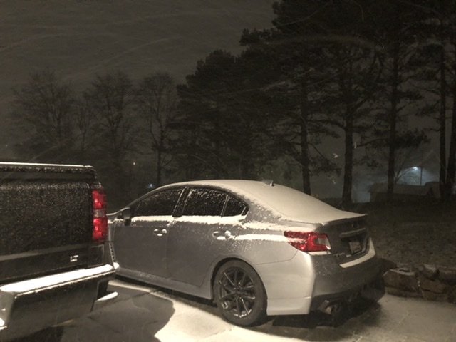
-
Central PA - Late Dec 2019/Jan 2020
MAG5035 replied to MAG5035's topic in Upstate New York/Pennsylvania
Count the 18z Euro as south of the region as well, some light precip near the MD border in the LSV but main precip south. Biggest model run of our lives coming up at 0z lol. -
Central PA - Late Dec 2019/Jan 2020
MAG5035 replied to MAG5035's topic in Upstate New York/Pennsylvania
18z guidance is coming in low so far. GFS and NAM slide the Tues system south of the area with pretty much no precip into our region on the GFS and a bit into the LSV on the NAM. NAM is colder and has a solid snow event in the DC/Northern MD/NOVA region and a bit of snowfall into the LSV but not a lot. That would figure lol. DC would have more snowfall on the season than me if that came to fruition. Anyways will have to see if this more progressive turn holds water in ensuing model runs. Also, I was laughing about @canderson still pulling weeds a few days ago and find today that my magnolia tree in the yard has a bunch of buds on it haha. -
Central PA - Late Dec 2019/Jan 2020
MAG5035 replied to MAG5035's topic in Upstate New York/Pennsylvania
The GFS finally joined the party today with having Tuesday's system, bringing the whole model suite into general agreement on the developing low from the Lower Mississippi Valley toward PA and then transferring to a coastal system. Question becomes if we hold enough cold at the low levels for a quick snow event. We will have some preceding cold for a change so I think a good part of our subforum area could see something snow wise from this with the Lower Sus Valley and southern tier being most in question for p-type at the moment. Like I mentioned the other day, it's still looking like something of the 2-5" variety at best with the northern tier and central counties having the best shot at possibly the higher end of that range. Still quite doable that LSV places like Harrisburg or even points south sees at least an inch or so. This is a window of opportunity in an ugly progressive pattern. Also keep in mind we haven't busted the MJO way out into Phase 5 yet either. I know it isn't much but there is at least a little winter potential to be talked about in our region. It beats the alternative. I took a peak in the Panic Room earlier this afternoon and lol. I know most of you read our subforum neighbors to the south and I think we're all quite aware we're in a relatively uh.. unfavorable pattern alignment heading onward into January. The very positive AO (as well as the NAO) is a big player right now.. that has to neutralize and/or reverse. Low heights and a strong polar vortex (progressive pattern) near the pole keeps arctic air bottled up and limits intrusions. At least the silver lining(s) of the MJO pulse forecast to go way into Phase 5 is that the tropical forcing and associated effects (major central Pac ridging) may eventually perturb the PV enough to get some changes up there.. maybe. Most models also appear to progress the pulse pretty rapidly as well in their MJO forecasts. But for now just a really ugly alignment that we're served up the first half of this month. -
Central PA - Late Dec 2019/Jan 2020
MAG5035 replied to MAG5035's topic in Upstate New York/Pennsylvania
Right now I think it's yet another case of close but no cigar. Models do have quite a dynamic 500mb shortwave that passes in what would be a pretty decent position, though they differ a bit on surface reflection with GFS/NAM having more of a surface low through PA transferring to the coast while the Euro appears to do this underneath PA. The GFS/NAM solution isn't going to work to get anything synoptic snowwise in central PA (too far north). The Euro solution gives the best chance of a changeover scenario but the lower levels are still lagging just a bit too long, especially in the Sus Valley. We don't have established cold or anything to work with initially, and I think the pattern's too progressive to allow this dynamic system to wind up in time to actually present a changeover scenario. Thus, right now I feel the western mountains and especially NE PA seem to stand the best chance of seeing snowfall with this developing low. -
Central PA - Late Dec 2019/Jan 2020
MAG5035 replied to MAG5035's topic in Upstate New York/Pennsylvania
The 12z Euro's version of the potential Jan 7-8 system delivered a snow event to the commonwealth today, joining the Canadian's insistence on such things the last several runs. Today's Canadian looked a bit too wound up overall with it's evolution of not only that system but the weekend system preceding it, but mega deep systems are a Canadian trademark. GFS hasn't had much of a system at all the last few runs in this timeframe. So tons of spread in solutions remains with this. The Euro solution still technically cuts but has some secondary reflection to the coast and is a weaker wave overall so cold air aloft doesn't get routed. The result is a slug of precip (likely snowfall) that runs across the state in a widespread 2-5" type solution. There's been plenty of discussion on the gloomy outlook of the pattern overall going forward, but a window of opportunity is going to be there early next week. -
Central PA - Late Dec 2019/Jan 2020
MAG5035 replied to MAG5035's topic in Upstate New York/Pennsylvania
Some decent squalls went through in the last couple hours, 0.5" new. -
Central PA - Late Dec 2019/Jan 2020
MAG5035 replied to MAG5035's topic in Upstate New York/Pennsylvania
This will be occurring later in the afternoon with the shortwave ushering in the precip and reinforcing colder air. The biggest threat for issues is probably west of the I-99/220 corridor but CTP is being proactive given some of the high res short range models. One would have to watch for wet roads with initially warmer temps to become slick quickly if the heavier snow squalls materialize. -
Central PA - Late Dec 2019/Jan 2020
MAG5035 replied to MAG5035's topic in Upstate New York/Pennsylvania
Meanwhile, outside of the Sus Valley tropics where the growing season apparently didn't end lol.. Special Weather Statement is out for a large portion of Central PA for the threat of snow squalls later today. Use caution if traveling that direction later on.. especially on I-80 where snow squalls seem to be synonymous with 30+ car/truck pileups on the regular. -
Central PA - Late Dec 2019/Jan 2020
MAG5035 replied to MAG5035's topic in Upstate New York/Pennsylvania
Too bad we're talking D8-10+, but 0z Canadian and Euro op showing how we can capitalize with the colder pattern progged to set in at the end of this coming week. -
Central PA - Late Dec 2019/Jan 2020
MAG5035 replied to MAG5035's topic in Upstate New York/Pennsylvania
It does appear we will set up for a more solid shot of cold toward the end of next week as we finally build some heights out west and in the Pac and dump a trough into the east. First though, we probably go through another potentially wet outcome late week as the potential system in that realm looks vulnerable to cutting with energy dumping into the west and driving up heights in the east. 500 pattern doesn't look bad overall prior to that this week with below normal heights across a majority of the US the first half of the week but not a lot of cold thats tapped quite yet. We should see a few seasonal days and probably some snow showers in the central and western mountains behind tomorrow into Mon's system. Models are in good agreement currently with this more significant pattern shift and cold shot beyond this week. The main questions being of course if we can score some opportunities and will it actually have some staying power (and at the current modeled strength). The current long range eventually really builds a central Pac ridge, which coupled with a -PNA, continued low heights overall near the pole (+AO) and no real blocking in the NAO realm still presents a potentially flawed pattern going forward. I'm talking beyond D8-10 with that, so nothing set in stone by any stretch of the imagination. If you think about it, you erase that lucky strike mid November snowstorm last year (which could have easily happened this November) and we're just about where we were at this time last year. A lot of us were shut out last December, which didn't quite happen this year, but we were looking towards the 2nd week or so of January for things to turn. Kinda why I'm not a fan of the cold November, you set up a good overall longer term pattern and typically they'll break down/transition after 30 days or so. The issues are a bit different this year, but we're still quite early in the game. If we get a decent pattern to set in as progged at the end of the week and it stick for a time.. we're only into the second week of January. -
Central PA - Late Dec 2019/Jan 2020
MAG5035 replied to MAG5035's topic in Upstate New York/Pennsylvania
Hope everyone had a good holiday. Guidance is all over the place next week with respect to whatever system decides to come about within the first few days of the new year after another cutting storm slotted for late this weekend. We're talking past D7 so the uncertainty is to be expected. The differences between the 0z GFS and Euro are pretty big tonight in that range. The possibility of a system to deliver something to the area is there, but I'm seeing some fundamental issues with the pattern overall. Cold air availability and source region seems to be an issue. Despite the model differences, you don't see much anomalous cold up in Canada at all until you get way out into GFS long range. The Euro is especially warm in this respect, having a lot of anomalously warm 2m temps in Canada and the US. Tonight's Euro didn't even really settle in much cold behind the weekend system. The GFS has the better 500mb look next week, and would be fairly workable. But it doesn't look especially cold and we could end up with another system that has, for example an okay track but still ends up with p-type issues. Also noticing a lot of low heights remaining near the pole. You don't see the PV (or a piece of it) centered over say, Hudson Bay. Low heights centered on the pole is indicative of a +AO regime, and the latest AO forecast is through the roof. +AO keeps the arctic air locked up poleward, and the fairly progressive regime in the mid latitudes (+EPO, no established PNA ridge, transient at best ridging in the NAO region) would seem to serve as reasonable explanation of our lackluster pattern at the moment. -
Fall/Early Winter 2019 Forecasts and Discussion
MAG5035 replied to pasnownut's topic in Upstate New York/Pennsylvania
I'll see what I can do haha. -
New thread and hopefully a new pattern for the better in the near future.
-
Fall/Early Winter 2019 Forecasts and Discussion
MAG5035 replied to pasnownut's topic in Upstate New York/Pennsylvania
Typically at about the lowest point of hopelessness down there and when everything's canceled til next year by mid-Jan is when they get wacked with some once in 30 years type snowstorm.


