MAG5035
-
Posts
5,882 -
Joined
-
Last visited
Content Type
Profiles
Blogs
Forums
American Weather
Media Demo
Store
Gallery
Everything posted by MAG5035
-
Central PA - Late Dec 2019/Jan 2020
MAG5035 replied to MAG5035's topic in Upstate New York/Pennsylvania
Think your going to be in a pretty decent spot for this one. -
Central PA - Late Dec 2019/Jan 2020
MAG5035 replied to MAG5035's topic in Upstate New York/Pennsylvania
0.6" with that opening burst of snow. Steady light snow now and a pretty decent easterly/southeasterly breeze with temps now down to 23ºF. -
Central PA - Late Dec 2019/Jan 2020
MAG5035 replied to MAG5035's topic in Upstate New York/Pennsylvania
Okay, over to all snow now coming down hard. @Blizzard of 93 the gap in precip doesn't look too large on PBZ radar, plus we've had some building of the initial wave of precip moving in from the western counties. I don't think we'll see too long of a lull in the precip, which is probably good because the really brief bout of sleet indicates to me that there was some robust warming aloft and the heavy precip wet bulbed that portion of the column back below freezing. Will have to see what it does once this heavy portion gets through here and the precip lightens up some. But yea, don't be surprised if that opening wave has a couple pingers in it when it gets to H-burg. -
Central PA - Late Dec 2019/Jan 2020
MAG5035 replied to MAG5035's topic in Upstate New York/Pennsylvania
Well, got the heavy echoes overhead and there's fine pingers mixed in already. So that's not really the start I was looking for. But we'll see how the column responds. Edit: Starting to get the big flakes -
Central PA - Late Dec 2019/Jan 2020
MAG5035 replied to MAG5035's topic in Upstate New York/Pennsylvania
Snow has started here, 25ºF. Saw NWS Pittsburgh post about having 1.1" with that initial band of snowfall earlier so hopefully can get a fast start here. -
Central PA - Late Dec 2019/Jan 2020
MAG5035 replied to MAG5035's topic in Upstate New York/Pennsylvania
Specifically that yellow thickness line that corresponds to the 850mb-700mb thickness in this situation. That's more specifically where we will see the column potentially go above freezing during the main precip portion from the WAA. Because of the warming in the mid levels 700-500mb, this is a situation that will snow above the traditional 5400 thickness number. -
Central PA - Late Dec 2019/Jan 2020
MAG5035 replied to MAG5035's topic in Upstate New York/Pennsylvania
Oh nah your fine, was just pointing out the terrain under where it is putting out those high totals. -
Central PA - Late Dec 2019/Jan 2020
MAG5035 replied to MAG5035's topic in Upstate New York/Pennsylvania
Geesh.. the most distinct line is running the east slope of the Allegheny front, which I'm within that zone. It's probably not exaggerating too much on the excessive sleet totals if the NAM is in fact correct with the heavy sleet scenario it has been putting out. Lot of the LSV in the 0.5-1" range. Even that much sleet on a couple inches of snow does wonders with anchoring the snowpack lol. -
Central PA - Late Dec 2019/Jan 2020
MAG5035 replied to MAG5035's topic in Upstate New York/Pennsylvania
Oh boy there goes the neighborhood haha. https://images.app.goo.gl/FKypy8UiR5yrecfKA -
Central PA - Late Dec 2019/Jan 2020
MAG5035 replied to MAG5035's topic in Upstate New York/Pennsylvania
This is getting into the range where I start weighing the near term and high resolution guidance more over the globals. Early looks at the HRRR with the first parts of the storm show a pretty decent burst of precip with the initial mid level WAA. Hopefully that gets realized on the ground and it doesn't take long to overcome whats going to be a dry airmass. Right now I think an inch or so looks good with that initial wave. The HRRR is showing the break in precip (although above I-80 doesn't have a break) but it also showing the main wave starting as snow even in Pittsburgh, which should bode well in the central counties and LSV. The 0z HRRR will be running shortly, and the 0,6,12,and 18z runs go out to 36 hours. So that will be something to have a look at within the next hour to see where things are at according to that. The 18z extended run really collapsed the rain/snow line down towards the mason/dixon line as the main wave pressed into the LSV. It might be light on the QPF though.. it's showing only a couple tenths of precip total in the south central and parts of LSV esp below the turnpike. Heck parts of Franklin county barely get a tenth. Probably too dry, but given the westerly component to this event with the low tracking across through the lakes above PA.. we might have to keep an eye out for a precip min east of the mountains in the southern tier. I generally agree with what CTP has out snow wise. Overachieving on snow totals in the majority of the area below I-80 is going to hinge on the magnitude of warm advection aloft. I think this is primarily a frozen event for us, but there might be a decent bout of sleet. On the other hand, heavy precip coming in could collapse the column enough to maintain snow for awhile with the main wave if there's more wiggle room with the wet bulbs.. which is a fair possibility. I don't think that initial wave completely saturates it. Temps probably will go a bit above freezing over most of the area for a time tomorrow evening after the main precip is past and the occluded front comes through and mixes out the cold at the low levels. -
Central PA - Late Dec 2019/Jan 2020
MAG5035 replied to MAG5035's topic in Upstate New York/Pennsylvania
The opening take from CTP this morning:
-
Central PA - Late Dec 2019/Jan 2020
MAG5035 replied to MAG5035's topic in Upstate New York/Pennsylvania
The snow shower action has stuck around longer tonight than I would have expected, and gotten pretty far into the LSV at times. Tried to do some measuring and I'm going to call it about an inch total for the snow this evening. Hard to measure because it was really blowing around when the squalls were moving through. A lot of the yard had 1.5-2" but the grass is still thick enough to skew that measurement. I finally made an actual 24" x 24" snowboard that will be ready to be put out for Saturday's storm. -
Central PA - Late Dec 2019/Jan 2020
MAG5035 replied to MAG5035's topic in Upstate New York/Pennsylvania
I’m just gonna hope this snow band dropping down takes care of the front end snow in advance haha.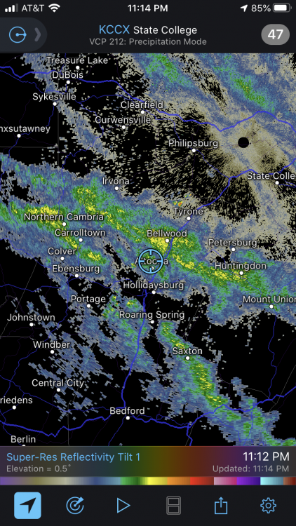
-
Central PA - Late Dec 2019/Jan 2020
MAG5035 replied to MAG5035's topic in Upstate New York/Pennsylvania
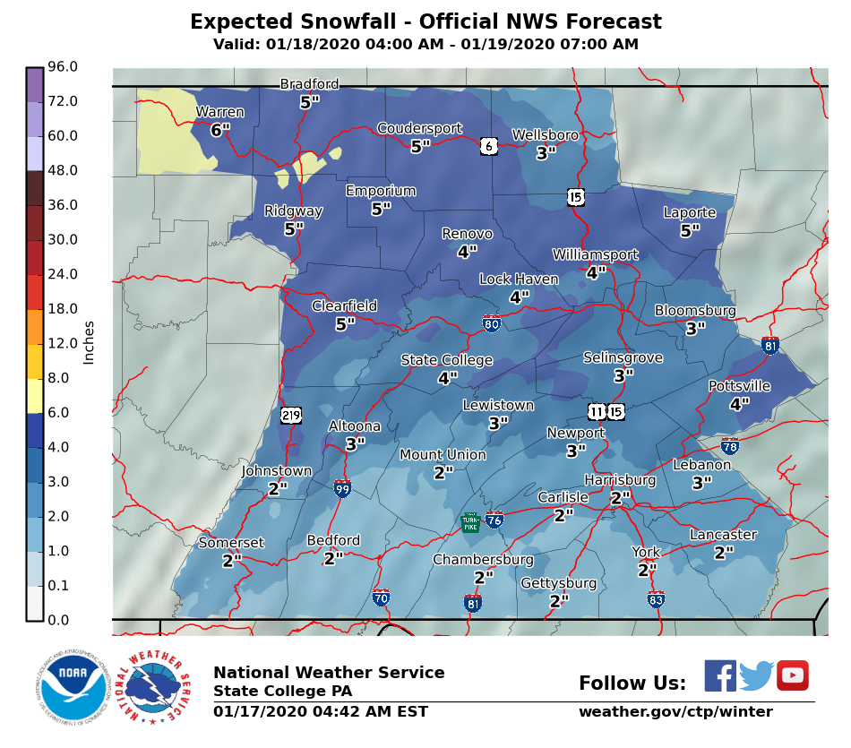
I dunno why snow amounts from the previous event (that unfortunately has long since melted away even) are a thing tonight but according to the snow totals into CTP, they ranged from 2.0" in Mechanicsburg to 7.0" in Boiling Springs in Cumberland County and excluding a couple early reports.. 2.9" at the Airport in H-burg to 5.5" in Hummelstown and near Elizabethtown with other H-burg suburbs in the 4-5" range in Dauphin County. I wouldn't consider a 4.0" near center city Harrisburg as being a suspiciously low-ball number. Most of the 5-7" amounts ran on a line just south of the city. https://forecast.weather.gov/product.php?site=NWS&issuedby=CTP&product=PNS&format=CI&version=5&glossary=0 -
Central PA - Late Dec 2019/Jan 2020
MAG5035 replied to MAG5035's topic in Upstate New York/Pennsylvania
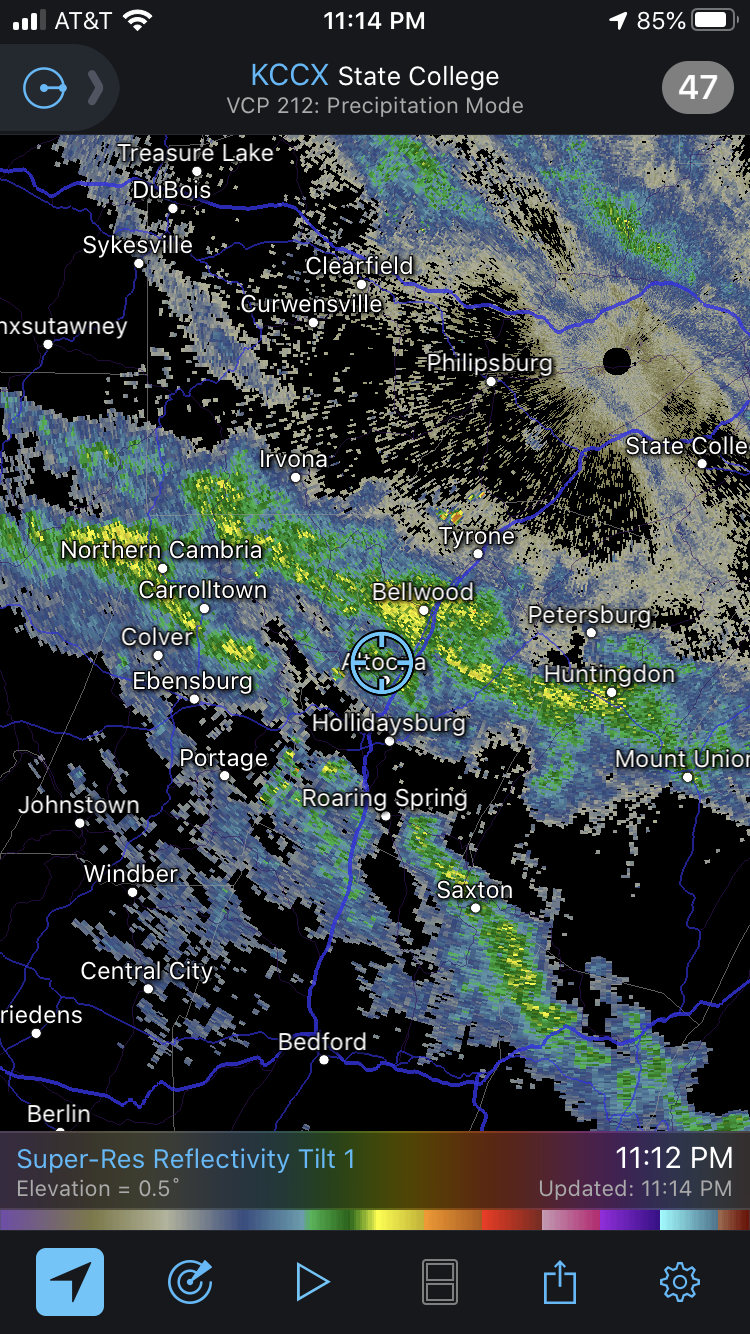
I'd say the lightning strikes over that area today probably have more to do with the low level instability and terrain than anything else. We've had some pretty strong snow squalls today with the sun being out + initially warmer surface temps vs very cold air coming in aloft. That patch of strikes is on the crest of the Allegheny front, so likely some extra lift had a part in that. That other patch in western MD is on the same general ridgeline. Here's the GOES loop with the lightning detection turned on https://weather.cod.edu/satrad/?parms=subregional-Mid_Atlantic-07-96-1-100-1&checked=map-glm_flash&colorbar=undefined -
Central PA - Late Dec 2019/Jan 2020
MAG5035 replied to MAG5035's topic in Upstate New York/Pennsylvania
After taking a pretty close look at the afternoon models, there's still some pretty sizable differences thermally at the different levels. The 18z NAM manages to be the coldest and warmest at one point... having the sharpest surge of 850 temps of the bunch (+4ºC all the way to the NY state line in western PA) while simultaneously having the coldest 925mb temps overall (with -6 to -8ºC over C-PA). Safe to say, that's why the NAM has a lot of sleet. The Euro and GFS have a good bit less of a surge at 850mb while being a bit warmer at 925mb but still pretty cold while most of the precip is falling. Those models have been surging the 925mb level but after most precip has fallen. The 12z GFS was the coldest at 850mb and thus had the coldest overall column which was why it was flirting with a mostly snow event over a large portion of the area. So there's all that...and I'll continue to note that this warm air intrusion aloft, whatever magnitude it is, will be brief. The maturing storm system in the lakes will already be wrapping cold around, and could in fact try to change some places back to snow as the 850 temps are already on the way back down late in the event. I think the central counties (esp I-80 north) stand the best chance of that scenario. Snowfall amounts are not only going to hinge on how solid the initial WAA snowfall is, and I think everyone should be good for at least a general T-2" from that... but also how well the column holds up when the main stuff arrives. If there isn't much of a break in between, I think most places could start the main wave of precip as snow as well. That's especially the case if the Euro and GFS are correct with less of an 850mb surge than the NAM's. Obviously from I-80 north this is predominantly frozen event to begin with and has the best chance of having several inches of snow/sleet. For the mixing I think sleet will be the dominant mix p-type. There probably will be some freezing rain to be had (Laurels, maybe southern tier) but this has a look of a more prolonged period of sleet vs it just being part of a transition to liquid/freezing. The cold 925mb temps in place are a big tipoff for me in that department. -
Central PA - Late Dec 2019/Jan 2020
MAG5035 replied to MAG5035's topic in Upstate New York/Pennsylvania
You still got me lol, 0.2" this afternoon here brings my total to 5.3" on the season. I'm essentially at 10% in terms of average snowfall for the winter. -
Central PA - Late Dec 2019/Jan 2020
MAG5035 replied to MAG5035's topic in Upstate New York/Pennsylvania
Tropical Tidbit's lumps sleet/ice into their 10:1 snowmap, which the NAM has a fair amount of. That's why you see really blown up snowmaps on that site in areas where p-type is potentially an issue... which btw I feel like every single significant winter event dating back to the beginning of last winter has had p-type issues. To add to that, the ICON p-type maps on TT is flawed a bit as well. There's only a conditional for snow and rain, not ice... so you won't see where there's mixing present on that one via the p-type map. -
Central PA - Late Dec 2019/Jan 2020
MAG5035 replied to MAG5035's topic in Upstate New York/Pennsylvania
Well today's 12z GFS was probably one of the better runs yet for the area from that model, essentially having a nearly all snow/frozen event for everyone north of the turnpike. The Euro doesn't have a lot of QPF up front, or overall really... probably about 50% of the GFS QPF. I don't see a tremendous difference thermally, 850's spike above zero very briefly and they're already crashing all within a 6 hr frame on both. The Euro just didn't have very much of a front end thump, whether that's right or wrong. My opinion attm is it probably is a bit too dry. Anyone with Euro ensemble products can probably see if that's reflective of such things on there. Still plenty of time, by this time tomorrow we'll be able to get some early hot takes on the NAM. This probably won't be an especially long duration storm either, pattern is still progressive. This thing is coming into the Pac NW, reforming on the other side of the Rockies and pretty much moving straight across at the same latitude. The strong high is there but it isn't anchored and will be moved as the storm approaches from the west. But cold air wraps around this system quickly and never really drives up anything torch-worthy aloft, so I think the cold will hold at low levels enough if the heavier precip is there up front. I'd say the top end potential is a 4-8 type deal for a C-PA location that sees a mainly frozen event. -
Central PA - Late Dec 2019/Jan 2020
MAG5035 replied to MAG5035's topic in Upstate New York/Pennsylvania
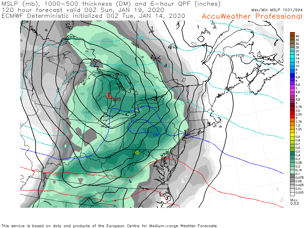
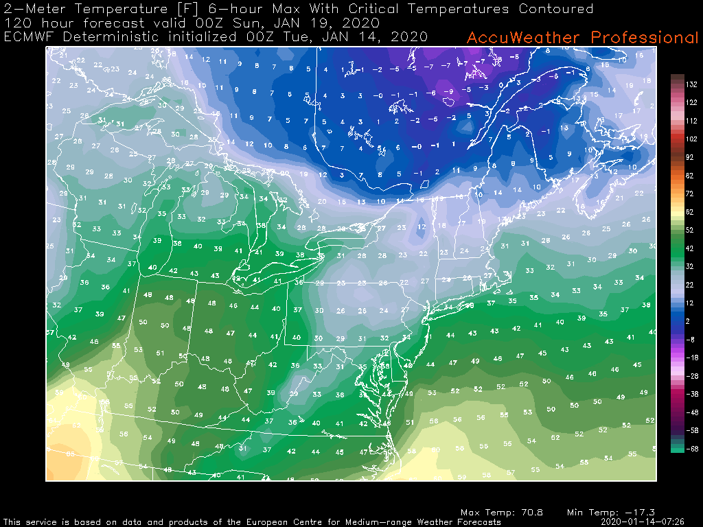
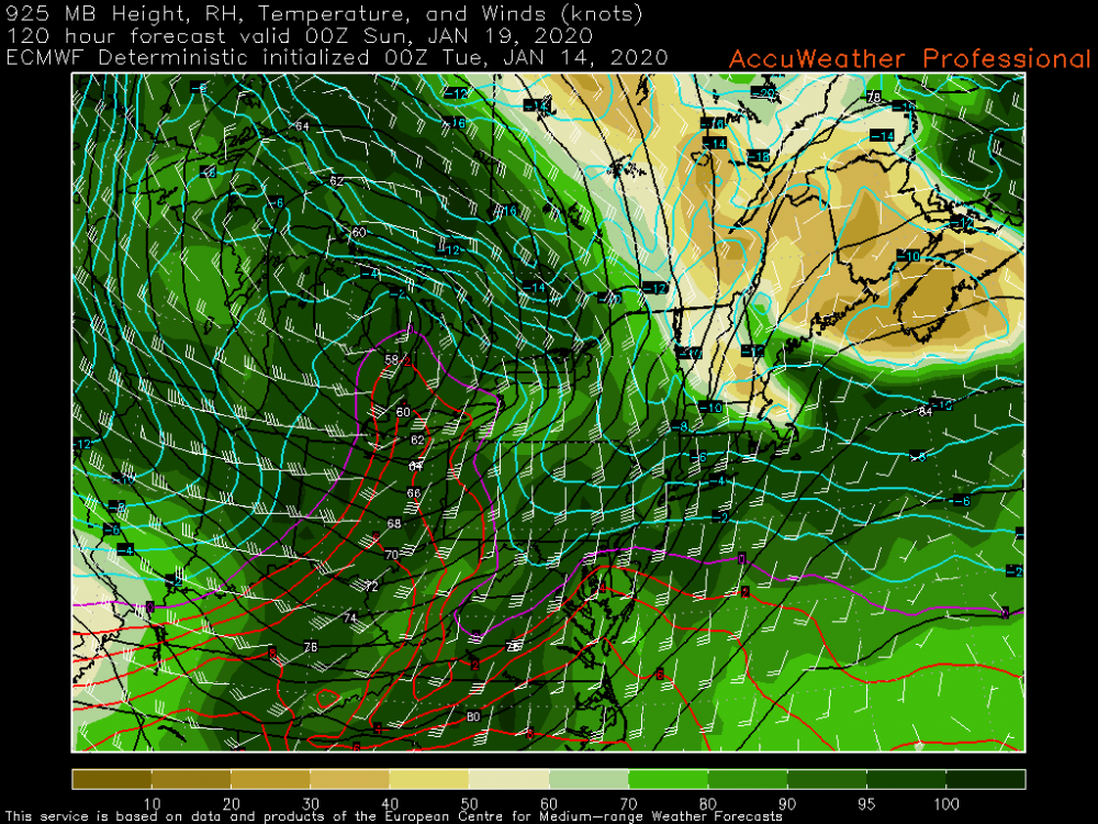
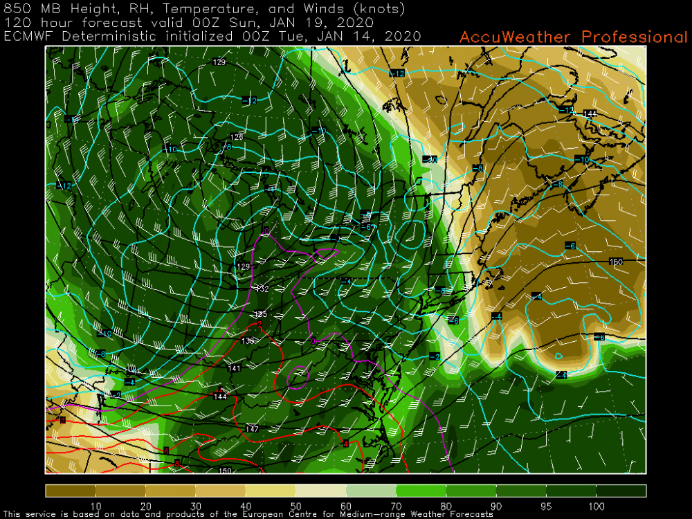
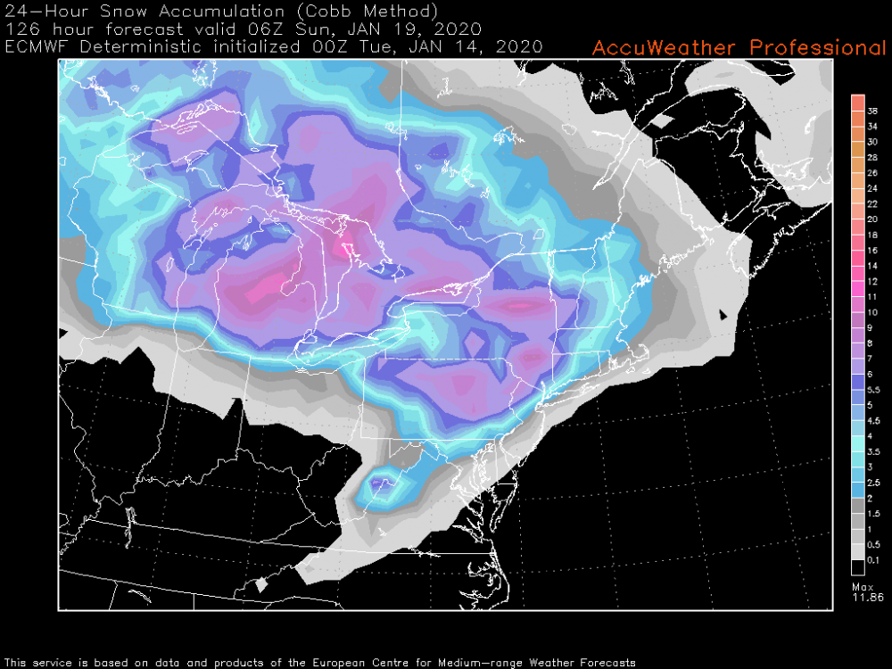
The money frame on the 0z Euro as it regards to 6 hr QPF (hr 120) in order of surface, 6 hr max 2m temp, 925mb, and 850mb levels. Also added 24hr snowfall ending at hr 126 using the Cobb method. Still at a pretty long range yet but just showing how I start breaking these complicated snow-mix setups down in the shorter term. The <0ºC 925mb temps are pretty well anchored and the 850mb level holds out fairly well despite a pretty strong SW flow aloft. The hr 126 frame shows the brief warmth surge at all levels but that's after most of the precip has exited. 2m temps reach the low-mid 30s region wide according to the 0z Euro. Also note the surface, 925, and 850 lows are stacked (near the same position) indicating a maturing storm and the occlusion I've been mentioning that will likely keep the warm surge brief and muted. As for snowfall the Euro overall seems to remain a bit north/northeast with it's heavy snow axis vs the GFS and esp Canadian, or at least a bit limited in the southern tier in the central counties, likely implying the Euro is indicating some kind of a mix (likely sleet) possibly knocking the totals down a bit. At any rate, a lot to unpack the next few days. Another thing to consider is if models continue to show the high at the 1045ish strength they've been showing, this may trend a bit colder yet as this gets into the short range model's range.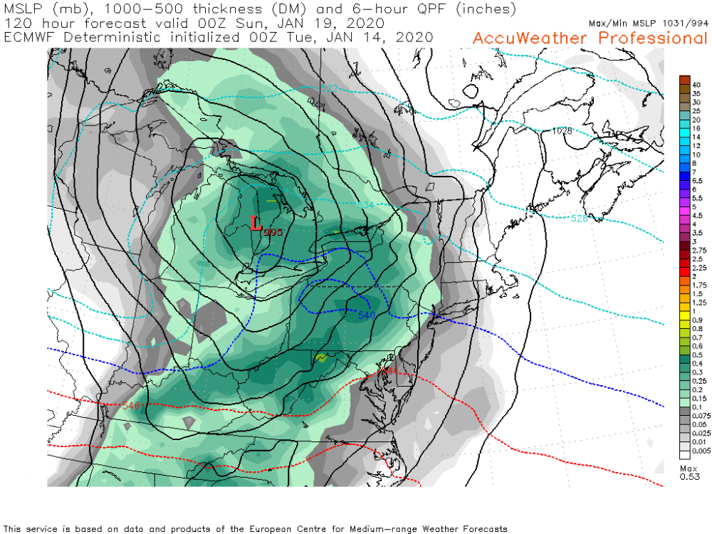

-
Central PA - Late Dec 2019/Jan 2020
MAG5035 replied to MAG5035's topic in Upstate New York/Pennsylvania
The strong high pressure being progged certainly bodes well for significant front end snows in the Sus Valley... reaching 1045mb as it moves through southern Ontario into southern Quebec. Even through the high eventually retreats as the storm presses through the lakes, that's going to be tough to displace low level cold east of the Laurel's. -
Central PA - Late Dec 2019/Jan 2020
MAG5035 replied to MAG5035's topic in Upstate New York/Pennsylvania
Remember the graphics they put out for an Alberta clipper the one time (awhile ago) that were straight out of the Microsoft Office clip-art section? -
Central PA - Late Dec 2019/Jan 2020
MAG5035 replied to MAG5035's topic in Upstate New York/Pennsylvania
Thank you for the kind words, I really appreciate it. I wish we still had some other met presence in here. I know a couple of our other regulars have moved to other places. -
Central PA - Late Dec 2019/Jan 2020
MAG5035 replied to MAG5035's topic in Upstate New York/Pennsylvania
The overall big picture features and their positioning for our end of the week system remain pretty firm today on the models... strong high placed to the north and a significant system tracking to the Lower Lakes with a decent chance at a nice front end snowfall for most of the area as well as a to be determined period of mixing. 12z GFS and CMC were the snowier models today with the Euro solution focusing its significant snowfall (6+) from I-80 north. As CTP mentioned in their disco this afternoon, those details will start really getting hashed out once the high res short range models are in range and in the fold with determining a consensus... so I wouldn't get too bent out of shape on run to run or model vs model differences. Given the pattern and a really good consensus track-wise on the models at what's still a pretty good lead time, I don't anticipate much deviation in the eventual track of this system into the Lakes. The strong high to the north will be a key for the front end snowfall and I believe the timing of the occlusion of the storm system along with how well the CAD holds will determine if the rest of the event is mostly on the frozen/freezing side. A track into the eastern lakes already implies our region we'll likely get slotted anyways late in the system after whatever damage is done. It does look at the moment that any warm surge into the area will be relatively brief. I mentioned some shades of last year's Jan 19th storm with this potential storm in my post this morning. This one as is right now would be a bit more NW (last year tracked into PA) but I believe would have a stronger high in place if I recall correctly. -
Central PA - Late Dec 2019/Jan 2020
MAG5035 replied to MAG5035's topic in Upstate New York/Pennsylvania
The 0z suite looked pretty good overnight, with a significant front end snowfall on both the GFS and Euro aided by the progged strong high pressure. The preceding shortwave mid-week is more notable on tonight's guidance which may be helping set the cold air boundary better. Euro solution was the snowiest, with a majority of the subforum seeing 6"+ on 10:1 maps. GFS had 6"+ north of the turnpike central and eastern thirds of the state but turned most of the area over to rain at the end. That usually doesn't happen as either the storm overall ends up warmer and you see less front end snow or you get significant snows up front and typically that's a colder/icier outcome after changeover. Euro solution presented an opportunity for potentially an all frozen event or snow to mix for some as it is a tad weaker with the primary and it looks to occlude/ try to transfer to the coast. Gonna be interesting to watch this evolve this week. Some shades of last winter's Jan 19-20th event.