MAG5035
-
Posts
5,882 -
Joined
-
Last visited
Content Type
Profiles
Blogs
Forums
American Weather
Media Demo
Store
Gallery
Everything posted by MAG5035
-
Central PA - Late Dec 2019/Jan 2020
MAG5035 replied to MAG5035's topic in Upstate New York/Pennsylvania
Yea I mean my big concern with regards to track is it ends up doing the whole miller-B process further north, with the primary getting into the lakes or something like that and setting up the I-90 corridor as you say. But that line of thinking is more reflective of how this particular winter has gone in terms of an overly dominant dose of storms to the lakes or tracking north of PA than overall C-PA storm climo. It's not necessarily that back here gets skipped over so much as late transferring miller-b systems, or simply more progressive systems that transfer to the coast a lot of times will send in an initial wave of WAA precip that shuts off when the energy goes to the coast. The result being say, we get an advisory or low end warning snowfall from a system that delivers a lot more further east and northeast once it gets more wound up. That's essentially what the 0 and the 6z GFS did. The problem with this is the marginal temps. I think the central counties can work with this as is even with the GFS solution, but the Lower Sus Valley is going to need a more robust secondary development to get things cold enough. -
Central PA - Late Dec 2019/Jan 2020
MAG5035 replied to MAG5035's topic in Upstate New York/Pennsylvania
Yea that's pretty much what happened there. It's my biggest concern about this system with the way things have gone storm track wise this winter. The deeper solutions that went under PA give all of us at least a half decent chance of something despite marginal temps but a late transfer would pretty much do in the threat for us. The good thing is that it's only Monday night on a Fri night-Sat threat. -
Central PA - Late Dec 2019/Jan 2020
MAG5035 replied to MAG5035's topic in Upstate New York/Pennsylvania
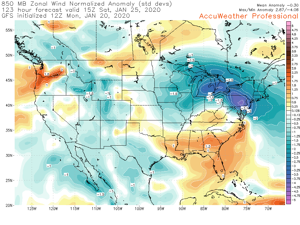
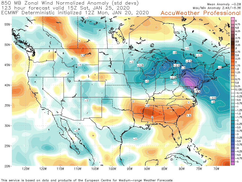
I dunno if i'd call it a "cold" high in the sense of it being a source of cold like we had for most of Sat's event but the presence of high pressure to the north to force the storm to the coast also sets up that LLJ they mention.. which is the anomalous easterly flow off the Atlantic. This storm has "the look" I want to see in that department, with the GFS having at least a -3 sigma at 850mb and greater than -5 at one point on the Euro (that's a really strong easterly fetch). That's a major tip off I look for with the potential of an excessive snowfall event, which I'll put up the examples below. Obviously the problem here is the marginal cold we're working with at that level (and overall). The Euro's very highly anomalous easterly flow at 850mb is probably too much for the marginal temps at that level, which leaves the LSV out of the snow but smacks the western half of the state. The GFS has been just a bit colder as well which has made the difference for the LSV. Looking at 12z guidance the Euro is a bit NW of the GFS with all the features (surface low and 850 low) and just a bit warmer aloft. Canadian seems the most NW for this model cycle out of the ops. I'd be curious for a look at GEFS and Euro ensembles. This storm happening as models generally have it would potentially be a higher category KU type NESIS event with just having a modified arctic airmass to work with. But without that this is still a possible heavy snow event, but it favors interior locations NW of the megalopolis and potentially NW of I-81 in PA if the slightly warmer Euro had it's way. 850mb wind anomalies 12z GFS at 123hr 12z Euro at 123hr

-
Central PA - Late Dec 2019/Jan 2020
MAG5035 replied to MAG5035's topic in Upstate New York/Pennsylvania
Same here haha. I gotta get to 50" to call it an average season back this way and I'm not even to 10" yet. -
Central PA - Late Dec 2019/Jan 2020
MAG5035 replied to MAG5035's topic in Upstate New York/Pennsylvania
Wow 6z GFS was a flush hit for Central and eastern PA. The 0z Euro was there too, but was warmer aloft and much more marginal, especially in the LSV despite having a nice 850mb low track passing underneath PA. Focus of accumulating snow was in the central third of the state (Euro control similar). GFS 850mb low was a tad further north but had colder 850 air overall and it was enough to make it a primarily snow event for pretty much the whole subforum. Definitely an interesting setup. The 500mb pattern straight up is definitely doable, with a sprawling area of anomalously high heights residing over Canada and the storm track undercutting that. In a winter that has featured a stupid amount of cutting storms and a northern branch that has stayed well above PA for the most part (remember clippers?)... I guess that's a way to finally try to force one underneath us. The problem though is the cold air in place now gets moderated this week and the true arctic air is bottled up in it's region of origin courtesy of low heights over the pole (continued +AO) as well as the aforementioned Canadian ridging, which it's positioning is progged to cover a large portion of that country.. cutting off the source region for any fresh cold. What is on our side with this setup is climo. That January 25ish timeframe is basically the bottom of the curve in terms of average temperatures for the year so we can definitely do marginal. Present this type of thing in late November/early December and it's probably raining for the most part. In late January with a progged track and evolution like the Euro/GFS, you would certainly have to favor snow in at least the central counties and potentially the LSV with a dynamic enough system. It's got to stay underneath us though, or transfer to the coast underneath us. Or else it's either going to rain and/or we're going to just barely miss out on a potentially sizable snowstorm like we did at the beginning of December. -
Central PA - Late Dec 2019/Jan 2020
MAG5035 replied to MAG5035's topic in Upstate New York/Pennsylvania
I can confirm it is quite the glacier as it was rock solid when I woke up early this morning. Some of the back roads refroze too. Pretty much if you didn't clear off your driveway/sidewalk last night your gonna have a bad day doing it today. At least this stuff should take a lakes cutter or two haha Definitely going to have to hope for a timely secondary or straight coastal low solution with the cold relaxing late in the week now. Canadian has it (secondary) and the GFS is to the lakes with no secondary. Way more uncertainty than yesterday's event had at this range. This has some potential, but it looks like we might have to rely on a more dynamic coastal low type outcome to ensure enough cold for any kind of widespread snows in the area. A weak secondary with a parent low up the Ohio Valley into the lakes might not be enough given the said late week moderation in temps. At least we're at the bottom of the curve in terms of climo. -
Central PA - Late Dec 2019/Jan 2020
MAG5035 replied to MAG5035's topic in Upstate New York/Pennsylvania
You’d almost think it was January or something today... Getting fluff bombed With some LES/upslope currently and have an inch or so new already. Or you know, more snow than I got from the actual storm yesterday.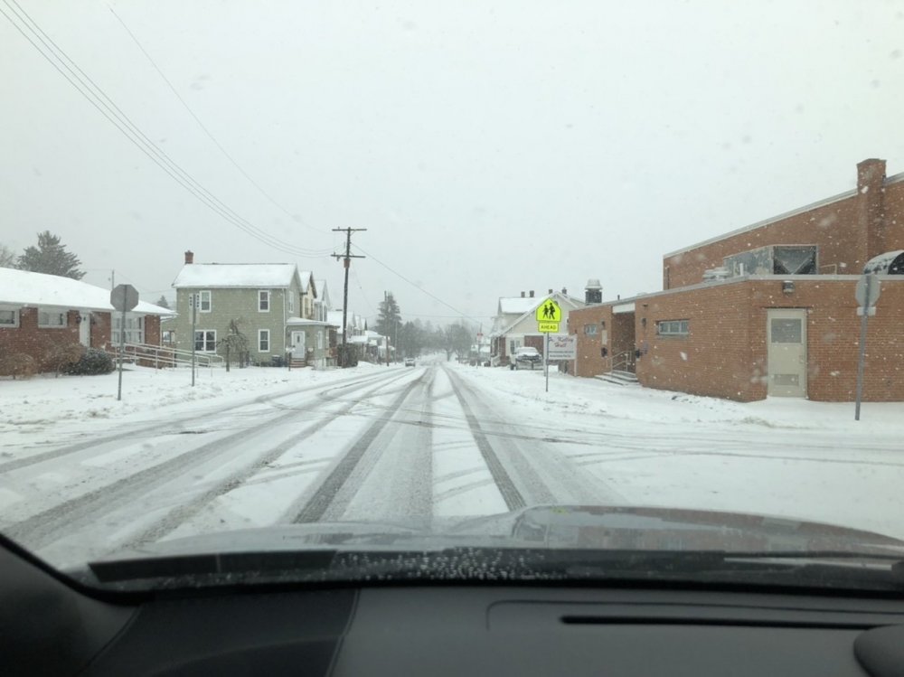

-
Central PA - Late Dec 2019/Jan 2020
MAG5035 replied to MAG5035's topic in Upstate New York/Pennsylvania
Temp did spike up to 41ºF a little bit ago but it's back to 38ºF and the wind's really kicked up. -
Central PA - Late Dec 2019/Jan 2020
MAG5035 replied to MAG5035's topic in Upstate New York/Pennsylvania
I was out for a bit when some of this is going through. It's in the 40s once you get up past the crest of the Allegheny front into Cambria County (which is a matter of 5-10 miles or so and 1100' up from here) but it's still 33ºF down here in Altoona. With the rain moved out I can see the low clouds above the city lights and they're flying by. So once those gusty winds mix down it's probably going to rapidly jump into the mid-upper 30s for a bit. But for now all untreated surfaces are still frozen with a tenth or so of ZR. There were some pretty decent downpours and it was enough that there's some ponding of water in spots where the plowed snow/sleet is blocking drains. Just miserable out. I'd almost take a fringe job while DC got 20" over this...ALMOST. -
Central PA - Late Dec 2019/Jan 2020
MAG5035 replied to MAG5035's topic in Upstate New York/Pennsylvania
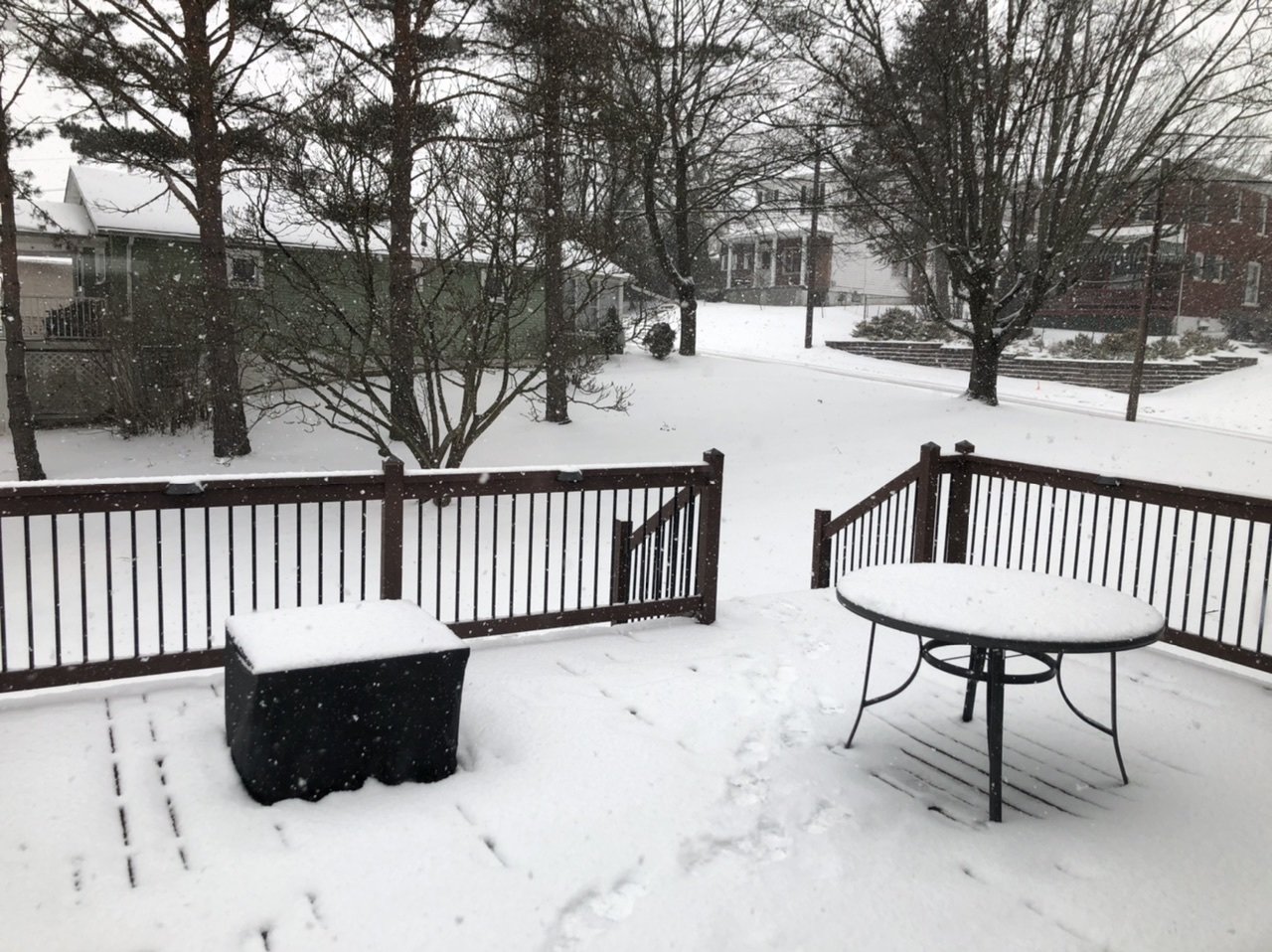
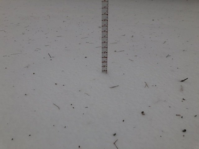
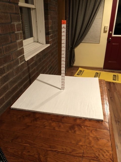
Couple pics before I cleaned up, plus the snowboard I threw together this week with some stuff I had around the house. I hope to use all 20 inches of that ruler at some point this winter. i left the snowboard untouched and measured the sleet off another surface, so it shows what the mess compacted down to (about 1.5").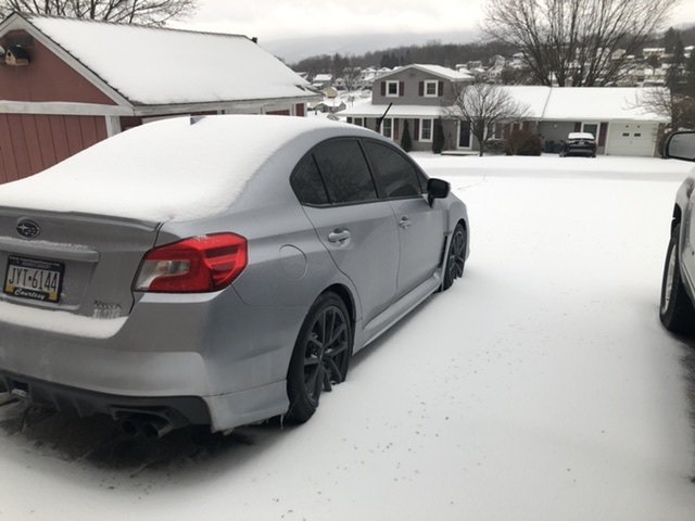
-
Central PA - Late Dec 2019/Jan 2020
MAG5035 replied to MAG5035's topic in Upstate New York/Pennsylvania
Just got in from getting everything cleaned up, we're getting patches of straight freezing rain now, with temps still near or slightly below 32ºF making for a nice glaze on everything. Totals were 1.2" of snow and 0.8" of sleet, making for an even 2.0" total... tied for the biggest snowfall of the season here lol. Roads and especially back streets are quite messy. Mesowest obs show temps have rocketed into the 40s in western PA and up to 37ºF now in JST. -
Central PA - Late Dec 2019/Jan 2020
MAG5035 replied to MAG5035's topic in Upstate New York/Pennsylvania
Still mostly sleet but some freezing rain is mixing in now as temps are up to 30ºF. Time to get this mess cleared off. -
Central PA - Late Dec 2019/Jan 2020
MAG5035 replied to MAG5035's topic in Upstate New York/Pennsylvania
Up to 0.5" on the sleet accumulation now. -
Central PA - Late Dec 2019/Jan 2020
MAG5035 replied to MAG5035's topic in Upstate New York/Pennsylvania
It's actually sleeting hard enough that you look out the window and the visibility looks like it could be a moderate snow falling. Still must be plenty cold for a way up, because there's no ZR mixed in with it. So I guess you could say it's a "dry, powdery" sleet lol. -
Central PA - Late Dec 2019/Jan 2020
MAG5035 replied to MAG5035's topic in Upstate New York/Pennsylvania
Moderate sleet, I cleared a spot to start measuring that and I'm at roughly 1/4" accumulation. -
Central PA - Late Dec 2019/Jan 2020
MAG5035 replied to MAG5035's topic in Upstate New York/Pennsylvania
Unlike on the other side of the Alleghenies (SW PA), we have the benefit of it being really cold up through 925mb (~3k feet). The 850-800mb (5-6k feet) layer is what were rapidly losing, as it wasn't very cold to start with for this event. So while it's looking like the mixing is going to probably get way up into the north central eventually, it's going to be predominantly sleet for most of us. I think any ZR will be confined to the Laurel's and possibly southern tier under the turnpike. Pretty much what the NAM had been advertising for several runs leading up to this. It had the strongest punch of 850mb temps but kept the 925mb layer very cold. -
Central PA - Late Dec 2019/Jan 2020
MAG5035 replied to MAG5035's topic in Upstate New York/Pennsylvania
I'm over to full pingers now. 1.2" and 25ºF. Maybe if the NAM sleet bomb verifies I'll end up with more sleet accumulation than snow lol. -
Central PA - Late Dec 2019/Jan 2020
MAG5035 replied to MAG5035's topic in Upstate New York/Pennsylvania
Still mostly snow but signs of a transition being pretty close. Rimed flakes and visibility is up. 1.1" has fallen. -
Central PA - Late Dec 2019/Jan 2020
MAG5035 replied to MAG5035's topic in Upstate New York/Pennsylvania
Yea hopefully, I'm already riding the edge here. I'll def know if it switches with the stiff breeze outside haha. Judging by that sounding from PBZ's 12z weather balloon this morning, that mesoanalysis looks like it might be running cold, especially at 850mb. We're definitely anchored in 925mb and under though. -
Central PA - Late Dec 2019/Jan 2020
MAG5035 replied to MAG5035's topic in Upstate New York/Pennsylvania
Snowing heavily, big flakes. -
Central PA - Late Dec 2019/Jan 2020
MAG5035 replied to MAG5035's topic in Upstate New York/Pennsylvania
Some light snow is restarting with arrival of the main batch. That mix line looks like it's already making a hard push past JST after blowing through Pittsburgh/SW PA, so will have to see what happens here when the heavier stuff gets here soon. The NAM is looking like it might end up being the more accurate depiction with what it's been showing. But again, we'll see how the column responds to the heavier precip. We have a much deeper wedge of low level cold air east of the Laurel's -
Central PA - Late Dec 2019/Jan 2020
MAG5035 replied to MAG5035's topic in Upstate New York/Pennsylvania
It’s cold out, these are the kinda temperatures you wish you had in place for a Gulf low heading to the Delmarva. -
Central PA - Late Dec 2019/Jan 2020
MAG5035 replied to MAG5035's topic in Upstate New York/Pennsylvania
I definitely think mostly frozen.. I bet you probably mix at some point but it would be sleet. CTP has you in 4-6" which I think is doable for you.. since your so far east and your also north too I'm sure you'll at least get to advisory criteria fairly easily as your pretty safely in the deeper CAD. Really interested to see what happens with this main wave just getting ready to get to Pittsburgh, it looks quite heavy and that gap between waves is closing up pretty fast. I see a couple mPing reports of snow across the border in Ohio under that heavy stuff. -
Central PA - Late Dec 2019/Jan 2020
MAG5035 replied to MAG5035's topic in Upstate New York/Pennsylvania
Steady moderate snow now, it is definitely a nice wintry morning out there with temps in the low 20s and a stiff breeze. Pretty fluffy snow. Shared this with the Pittsburgh folks and might as well throw it over here too, as it has implications for us downstream as well. Their 12z weather balloon launch this morning, so that's where the atmosphere is actually at and not where it's modeled at. Mentioned last night how high res models like the HRRR were collapsing the snow line south when it got into central and the Sus Valley, well that weather balloon sounding would be how that would happen even if there's a bit of a lull ahead of the main stuff and temps aloft sneak above freezing.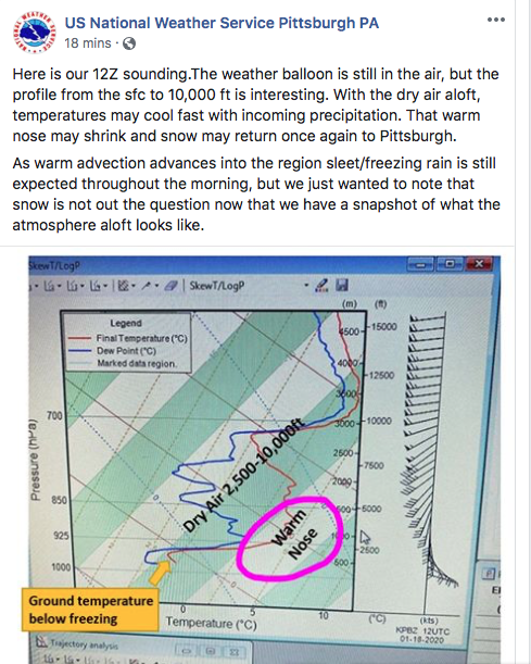
-
Sharing this with you guys.. saw NWS Pittsburgh post this not too long ago. Something to keep an eye on when that main precip arrives. That's their 12z weather balloon launch so that's the actual assessment of the column and not the modeled one. Definitely plenty of room to wet bulb that warm nose back below freezing with the arrival of the heavier precip. Hopefully you guys can sneak some more snow out of this.