MAG5035
-
Posts
5,882 -
Joined
-
Last visited
Content Type
Profiles
Blogs
Forums
American Weather
Media Demo
Store
Gallery
Everything posted by MAG5035
-
Central PA - February 2020
MAG5035 replied to Itstrainingtime's topic in Upstate New York/Pennsylvania
I'm taking a 9.6" total for the winter into February with the largest snowfall being 2.1". Going back to 2000, the only worse start to date was 06-07. Other horrendous winters of note in that time frame.. 01-02, 11-12, and 15-16 all had January warning level snowfall events here.. with 01-02 and 15-16 having double digit ones. Pretty special level of bad so far lol. -
Central PA - February 2020
MAG5035 replied to Itstrainingtime's topic in Upstate New York/Pennsylvania
12z Euro had a boatload of freezing rain with that second(ish) wave of low pressure late week and even some frozen at the end of the first wave and the start of the second. A press of cold air is becoming evident with a high sliding to the north on the models mid-week. How much of a press of cold will obviously determine what kind of p-type issues we have along with the track of the second low pressure wave, which would appear to be the primary event for widespread winter weather potential. 12z GFS relatively on it's own so far for the 12z model cycle tracking the low up the coast, as ensemble guidance seems to be currently more supportive of the low track the Euro and Canadian take with this. All have varying degrees of mixing. I know the Euro has shown what the 12z GFS has in a couple previous runs the last few days. A more progressive solution in a progressive themed winter certainly isn't out of the realm of possibility, and that would help us in that scenario. There's going to be a lot to resolve the next few days. -
Central PA - February 2020
MAG5035 replied to Itstrainingtime's topic in Upstate New York/Pennsylvania
I was pretty busy yesterday and this morning and am now starting to look into things again going forward and man was I having trouble finding something positive today. The renewed +AO surge had a lot of spread in the guidance the other day but looking at it today shows a pronounced return to the magnitude we saw in the first half of January, along with a surge back to a more solidly +NAO. Don't have to go much further into it to point out how the longer range of the models have responded to that, taking away what had been looking to be finally a more sustained period of cold weather. It's not that the cold isn't around.. it just isn't able to stick for more than a couple days at any kind of significant (-) anomaly... and it also makes us vulnerable to a high northern branch and/or cutter regime, depending on how much the PNA/EPO screws us up too. Certainly looking like a lot more of a challenge to go on a run of winter weather one could deem a "comeback". With all that said, next week does bare some watching. There's going to be a clash of temps on the frontal boundary and what appears to be a couple different waves to potentially run it. Not far off from a wintry mix/ice scenario with the first wave of precip mid week as cold temps bleed back down south at the surface with a somewhat modest high crossing north. Some guidance gets the mix into portions of C-PA. Then there's a second wave late week that runs up. GFS/Canadian run it up west of the mountains and the new Euro runs it up the coast, providing a swath of snow up through the middle of the state. So we'll have to watch how that evolves over the weekend and while we enjoy the run of warmth early next week. Sus Valley looks good for at least a couple days of 55-60, but far southern could certainly do better. I don't think we're going to see an all out heat wave, but all of us should see 50s and up for 2-3 days. Sidenote: I've finally decided to give WeatherBell a try as I've wanted access to its better and more extensive ensemble products among other things, instead of say waiting to see someone post ensemble maps (usually in the Mid-Atl with the DC centered map) for instance. So I'm armed with all that now. -
Central PA - February 2020
MAG5035 replied to Itstrainingtime's topic in Upstate New York/Pennsylvania
We'll have your name changed to "itssnowingtime" by the end of the month. -
Central PA - Late Dec 2019/Jan 2020
MAG5035 replied to MAG5035's topic in Upstate New York/Pennsylvania
Yea we’re due for a new thread anyways, we did get a whole month out of this one. -
Central PA - Late Dec 2019/Jan 2020
MAG5035 replied to MAG5035's topic in Upstate New York/Pennsylvania
The Great Lakes are pretty much wide open too. Ice coverage is at a measly 5.6%, which isn't completely unheard of this time of the year but certainly a strong indicator that this winter has had a lack of any sustained cold in the Eastern US and Great Lakes Region. If we do eventually see an actual dead of winter grade cold shot sometime next month there is going to be some major lake snows for folks underneath the favored flow off the lakes. -
Central PA - Late Dec 2019/Jan 2020
MAG5035 replied to MAG5035's topic in Upstate New York/Pennsylvania
That's what something like this will get you. And that chart was just high temperatures too, I'd like to see what the low temperatures looked like.. especially during the warm spell.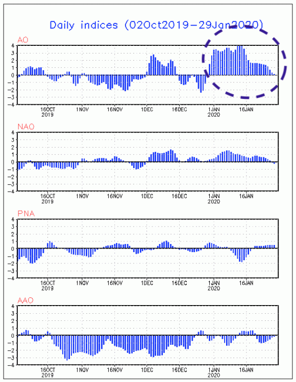
-
Central PA - Late Dec 2019/Jan 2020
MAG5035 replied to MAG5035's topic in Upstate New York/Pennsylvania
Not sure if your lumping in the Mid-Atlantic folks but there hasn't been anyone in this subforum that has called this event DOA, including myself who's been pretty pessimistic on this storm threat the last couple days. I'm not going to sugarcoat a setup that doesn't look that ideal, but I'm also not ruling out seeing enough of a tug north to get something into the southern parts of the area. The northern branch wave progged behind the departing coastal may also deliver light snows, something I mentioned on Monday. The Euro has been a bit more amplified with that feature and the 0z threw a large swath of 1-2" across PA from that. -
Central PA - Late Dec 2019/Jan 2020
MAG5035 replied to MAG5035's topic in Upstate New York/Pennsylvania
Still too much progression and positive tilted alignment for my liking with this upcoming storm. The western ridge is pressed east/flattened and it limits the northern branch's ability to dig down and pull this up in time. GFS/Euro bury a lot of energy into Mexico, while the 12z Canadian didn't and offered the most coherent attempt at some interaction..thus being the closest of the bunch at 12z. CTP had a decent discussion about this in their long term this morning. -
Central PA - Late Dec 2019/Jan 2020
MAG5035 replied to MAG5035's topic in Upstate New York/Pennsylvania
Well the first step to any snowy pattern is getting the daily 6z GFS ice age run. -
Central PA - Late Dec 2019/Jan 2020
MAG5035 replied to MAG5035's topic in Upstate New York/Pennsylvania
Lol I wish it was that easy. -
Central PA - Late Dec 2019/Jan 2020
MAG5035 replied to MAG5035's topic in Upstate New York/Pennsylvania
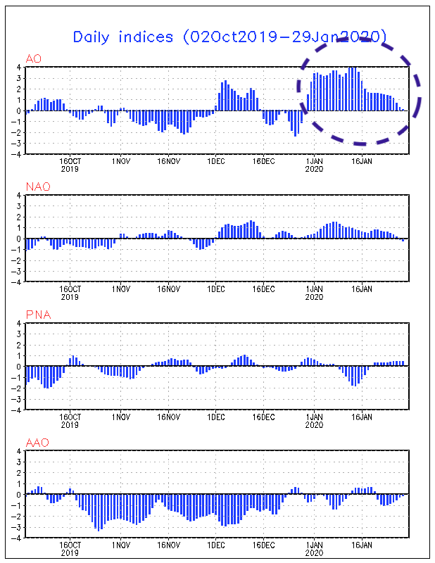
I think the coastal is going to happen but as I posted last night I don't like the pattern alignment and the lesser amount of amplification that's being advertised now with regards to getting whatever magnitude of coastal storm close enough to us. There is some hints of some northern branch energy dropping down enough for perhaps lighter snows behind the exiting coastal and before heights rebound for what looks like a more above average few day period getting into the 1st week of Feb. Something like that might favor the western part of the state though. I wouldn't write off February, especially after the first week. The long range has been really building a major ridge in the NAO realm as well as finally driving some + heights over the pole (improving AO) and improving the Pac/west coast some. I'm certainly aware of the "always 10-15 days away" theme this winter but the more wholesale change to a colder regime in the east had been also advertised by some of the longer range stuff like the Euro weeklies and CFS as well. We can still flip things around and there's been worse first halves of winter. 2006-2007 was pretty much dead on arrival til about the week of the V-day '07 storm. I think LSV places like York and Lancaster didn't even record measurable snowfall til like the first week of Feb that winter. At any rate we have to relax the AO if we're going to get a colder regime that actually sticks for more than a couple days. I think the very positive AO regime that developed at the end of Dec and lasted all this month has had the biggest overall influence on our sensible weather here. We can do okay with snow and cold in this region without the negative NAO but the +AO, especially at the magnitude it had been at, is hard to deal with. The strong PV over the pole locks up the arctic air, making cold air intrusions quick and also really raising the latitude of the northern branch. We haven't had a single clipper this year drop down anywhere near our latitude. I feel it's rearing it's ugly head again this week to a degree with the northern branch not amplifying enough to pick up the southern wave.. although the +EPO is also a detriment keeping things progressive and the source region of air Pacific. That PennLive article actually had a couple decent sources, referencing Judah Cohen at AER. He provides a weekly update and discussion on the state of the polar vortex and the AO HERE. The last discussion was Jan 20th, so an update is probably due today or tomorrow. -
Central PA - Late Dec 2019/Jan 2020
MAG5035 replied to MAG5035's topic in Upstate New York/Pennsylvania
Today's 12z Euro pretty much kept the northern and southern stream shortwaves separate, while the GFS is more amplified and interacts the two streams.. drawing more of an event toward the Northeast US. On the 18z GFS the interaction does generate an area of lighter snows crossing the state despite a weaker, more progressive coastal that's tracking a bit east of ideal for our area. Neither seem as amplified as a couple days ago when they were running significant lows right up the eastern seaboard. The overall 500mb alignment of the western ridge/downstream trough looks very positively oriented. Thus, I'm not particularly enthused with this becoming a big coastal (or developing into one in time for us) at the moment. With that said...there's definitely plenty of time as we have all week to see how things change, and there isn't much agreement or continuity on the models right now. -
Central PA - Late Dec 2019/Jan 2020
MAG5035 replied to MAG5035's topic in Upstate New York/Pennsylvania
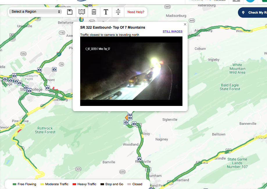
Well this storm had some snowy surprises up it's sleeve after all. This cam is east of State College on US 322 near the crest of the Seven Mountains area. That truck is stuck. Edit: They flipped the camera around, there's a bunch of stuff stuck. Also got snow on roads on the 511 cam near Mill Hall/Lock Haven.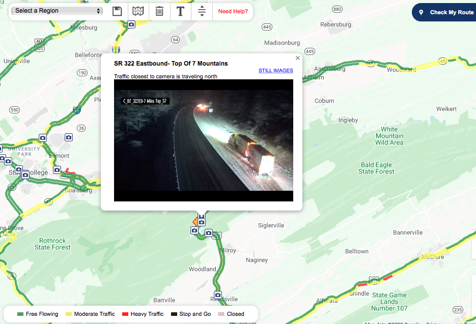
-
Central PA - Late Dec 2019/Jan 2020
MAG5035 replied to MAG5035's topic in Upstate New York/Pennsylvania
CTP did acknowledge next weekend in the long term this afternoon. -
Central PA - Late Dec 2019/Jan 2020
MAG5035 replied to MAG5035's topic in Upstate New York/Pennsylvania
Nah your not being selfish haha, I thought it was a good opportunity to bust out the vintage TWC coverage. -
Central PA - Late Dec 2019/Jan 2020
MAG5035 replied to MAG5035's topic in Upstate New York/Pennsylvania
Lol, well it was probably wasn't as memorable for most of the LSV but there was major nor-easter in Dec '92 that dumped similar snowfall amounts to the 93 superstorm in the interior. I think 50+ of UNV's 92" that season came just from those two events. Back when this part of the state used to see 20"+ snowstorms. -
Central PA - Late Dec 2019/Jan 2020
MAG5035 replied to MAG5035's topic in Upstate New York/Pennsylvania
Def a decent signal for a storm in that D8 or so timeframe, as models set up a nice western ridge for a change and it appears to be a time of amplification overall in the pattern over the CONUS. The Euro's southern wave kinda gets buried initially and seems like a later interaction with the northern stream, causing what it had at 12z. GFS and and Euro control had earlier phasing and thus cut the low too far west. Going to come down to timing of shortwaves, position/amplitude of the western ridge, and amount of phasing. There's a lot of different shortwaves running around in that time period on the models, so there could be some wound up solutions showing up (like yesterdays 954 on the GFS) if there's a clean phase. So yea, the potential is there. That's all the further I'm going into it for now. After how this week went for what ultimately is ending up a rainer for everyone inbound tonight and tomorrow I'm on a prove it to me basis for anything that doesn't actually cut west of us. -
Central PA - Late Dec 2019/Jan 2020
MAG5035 replied to MAG5035's topic in Upstate New York/Pennsylvania
It has seemed like we've had a lot of swing and misses so far this winter compared to 11-12. Of course that one did have one decent coastal hit.. on Halloween. I remember having a 7-8" snowfall in January, which I just found digging through my pictures. My biggest snowfall to date this winter is 2.0".. so I'd call this one worse so far personally. 11-12 was really warm in Feb-March if I recall correctly and that winter was different ENSO wise, being a solid La Nina the whole winter. Obviously things still have time to turn around in this one. -
Central PA - Late Dec 2019/Jan 2020
MAG5035 replied to MAG5035's topic in Upstate New York/Pennsylvania
Yea your right, I probably should have worded that better. They had been tightening up the snow zone toward the central third of the state NW of I-81, but that portion of the state had been pretty stable with strong ensemble support. Taking snow out of the AOO-UNV corridor and out of a lot of the north central as well was a pretty big shift today. Although I haven't seen the ensembles yet. -
Central PA - Late Dec 2019/Jan 2020
MAG5035 replied to MAG5035's topic in Upstate New York/Pennsylvania
Yea if this ugly 12z suite ends up coming to fruition, thats going to be a tough bust on those models. Seems like they're starting to keep the primary dominant too far north as it does get into Michigan.. which probably won't work for most anyone in here unless we have a rapidly intensifying coastal low. Just looking at the NAM for instance we have no redevelopment of the 850mb low instead having the original one going into the lakes and sending in warmer 850 air. This is a change from earlier runs a day or two ago which were bringing the 850 low over or just south of the area. Just not going to work without any established cold air. This isn't even looking all that great in NY State either, seemingly more relegated to the high ground up there. The EC and GFS busted pretty good in the central on Sat too, the GFS moreso... having a warning snowfall close to game time at UNV when the reality ended up being about 2 inches or so and a lot of sleet and even freezing rain for not only there but most of the north central. The GFS in under one cycle has went from about a foot at UNV to pretty much zero at 12z today. Thats rough, but that's what we're working with here.. a degree or two aloft either way turns this to a snowstorm or yet another rainstorm. We'll see what the Euro does, what the 12z ensembles look like, and go from there with the 18z and 0z tonight. There's still a chance the storm evolution goes back the other way as this is only 1 run. -
Central PA - Late Dec 2019/Jan 2020
MAG5035 replied to MAG5035's topic in Upstate New York/Pennsylvania
The overnight guidance I thought solidified a good bit with a more defined miller-B transition... perhaps a little bit high on the latitude with the primary before transferring but otherwise a workable track with plenty of QPF to be had in the region. The problem is becoming more about the marginal column temps in place ahead of the system as well the models predicting the secondary low a bit more inside the coastline, more of a coastal plain runner. That inside track hurts the Lower Sus Valley, especially York/Lancaster counties. But even more of a coastal track is an issue trying to get 850 temps cool enough in especially the LSV and it's close too.. only a matter of a couple degrees. The north-central is in the best shape with this currently, and the central between I-80 and the turnpike and further NW of I-81 is as always.. the most complicated to nail down. Could be rain to 1-2" of junk or a 6-10" shallacking.. or both. One positive I have noticed is the high to the north has quietly been being progged a bit stronger as we've gotten closer. I see the 12z NAM has started things off in the wrong direction. -
Central PA - Late Dec 2019/Jan 2020
MAG5035 replied to MAG5035's topic in Upstate New York/Pennsylvania
Well giddy or not, this threat is now inside D4 and the 2-3 straight days of that stripe of 6"+ in pretty much the same section of C-PA on the Euro EPS has my attention. -
Central PA - Late Dec 2019/Jan 2020
MAG5035 replied to MAG5035's topic in Upstate New York/Pennsylvania
There's some signs of eventual coastal development, but it's hard to take stock in trying to determine what it will do...especially being the NAM at that range. It does show a 1036mb high just north of Maine, which is a bit stronger than the GFS and Euro. But otherwise it looks in the ballpark of the 6z GFS at 90. 6z Euro to 90 has the low more SE and is actually a stronger looking system. I'll be curious to see what the ensuing frames look like if the 12z Euro is still looking like that.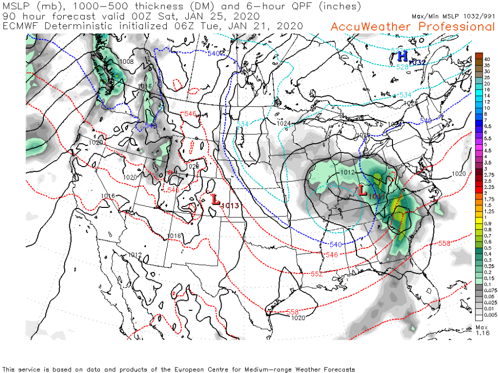
-
Central PA - Late Dec 2019/Jan 2020
MAG5035 replied to MAG5035's topic in Upstate New York/Pennsylvania
93 and 96 were Miller A's. Somewhat more recent big storms with some miller B type characteristics are the 2003 PDII and Feb 5-6, 2010 storms. Those two had surface low reflections just west of the Apps that transferred over, but obviously much better blocking and cold air in place.