MAG5035
-
Posts
6,078 -
Joined
-
Last visited
Content Type
Profiles
Blogs
Forums
American Weather
Media Demo
Store
Gallery
Everything posted by MAG5035
-
Central PA 2020 Fall - The Hope begins
MAG5035 replied to paweather's topic in Upstate New York/Pennsylvania
This was my post on this last night, as CTP had a good explanation in their discussion. -
Central PA 2020 Fall - The Hope begins
MAG5035 replied to paweather's topic in Upstate New York/Pennsylvania
Pretty interesting and informative disco from CTP tonight...A little reminder of Meteo 436 (Atmospheric Radiation) a long time ago. Adjusting temps down some tomorrow due to the smoke remaining in the upper levels. Frost advisory up for McKean County (Bradford area) tonight. -
Central PA 2020 Fall - The Hope begins
MAG5035 replied to paweather's topic in Upstate New York/Pennsylvania
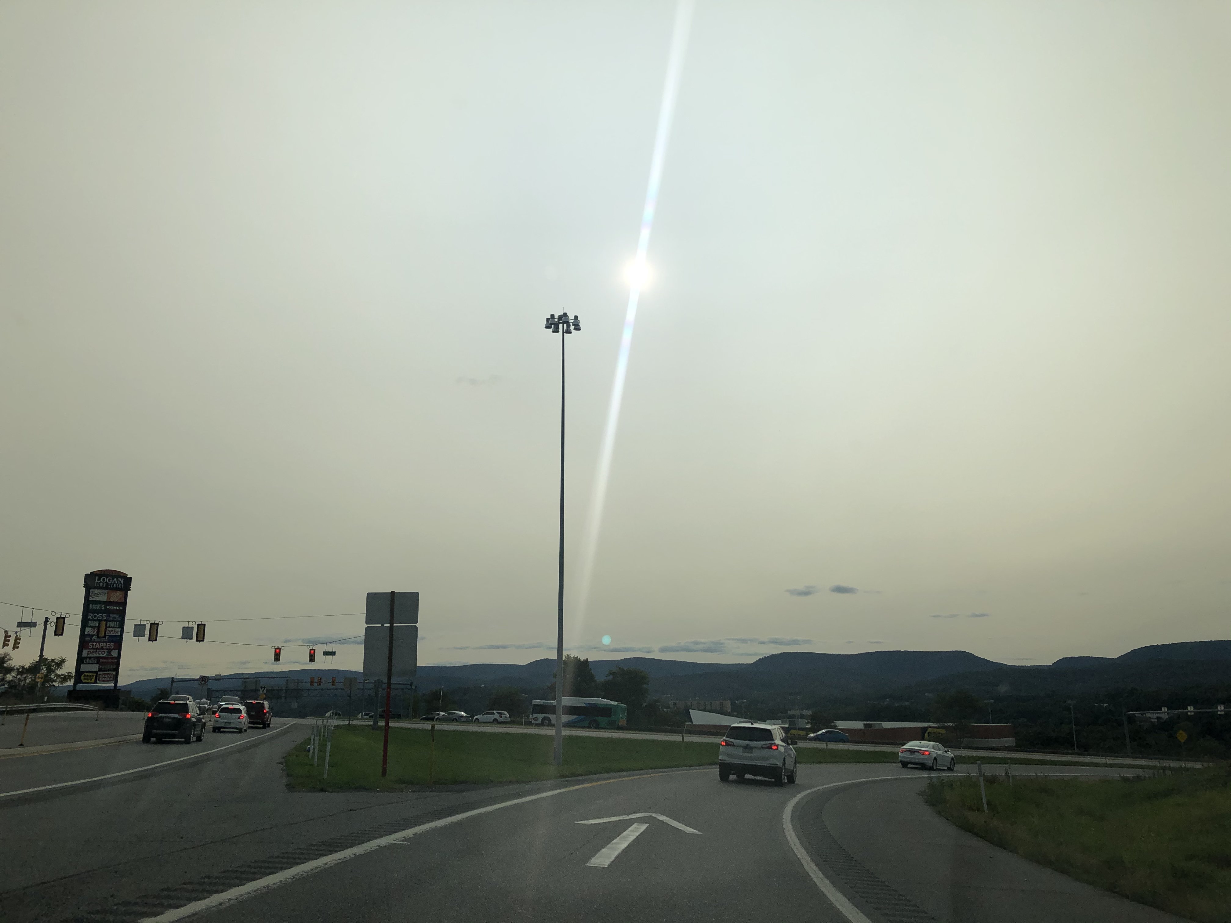
Pretty impressed how much the sun was filtered through the smoke in the higher levels today. Took this coming back into town about 20 min ago.
-
Central PA 2020 Fall - The Hope begins
MAG5035 replied to paweather's topic in Upstate New York/Pennsylvania
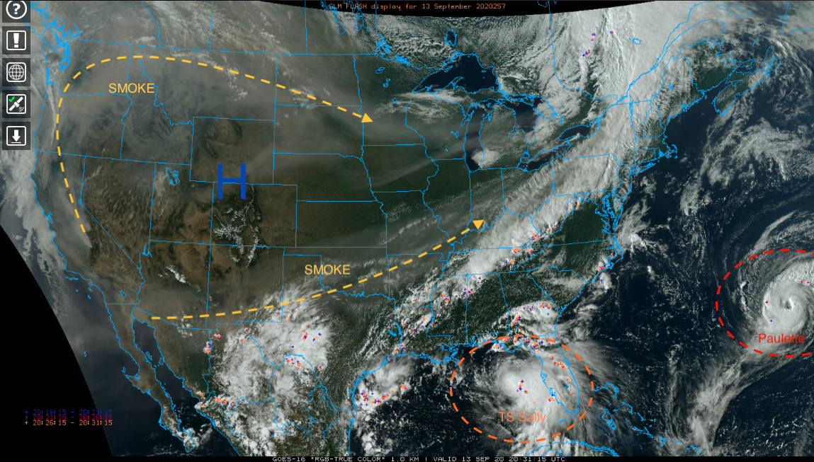
I don't think we've made it to 70 here today under the clouds and had a couple decent showers late morning/early afternoon. Pretty much been cloudy here since Friday. You can see on satellite how the frontal system working through central PA this afternoon has drawn some of the western wildfire smoke up into it at the higher levels from the SW and also from the NW some. Also you can see the two big ticket tropical items Paulette and Sally. Will have to see how much Sally eventually gets drawn up north before being shoved out ahead of another frontal push late week. Euro ensembles show some reasonable precip chances southern half of the state but right now it seems the general model consensus is the majority of eventual remnants stay south of PA. So we'll see how that goes. Right now Sally's being forced under the current frontal boundary to take its forecasted WNW toward the LA coast. That's also contributing to the westerly shear on it attm as well. Hopefully it doesn't get too wound up, because that is a bad angle to take towards New Orleans. Next weekend looks dare I say, kind of chilly behind the system that eventually kicks Sally away. Could be a decent chance of some frost in northern PA as well as the usual cooler suspects in the Laurels and central counties. The first couple days this week after the passage of today's system looks pretty nice as well, with Tuesday morning the chilliest and a more limited frost chance (Bradford/Allegheny National forest region).
-
Central PA 2020 Fall - The Hope begins
MAG5035 replied to paweather's topic in Upstate New York/Pennsylvania
Goodness I hope everyone has a quick/full recovery from all the injuries. We're gonna have to put out an injury report when we're full swing in the wintertime at this rate lol. -
Central PA 2020 Fall - The Hope begins
MAG5035 replied to paweather's topic in Upstate New York/Pennsylvania
Today was low key one of the more muggy days of a summer that's had wall to wall hot weather but not necessarily much of the hot/humid combo. That region seems to be on the kind of insane run of way above average precip that the LSV saw the last two summers (especially 2018). -
Central PA 2020 Fall - The Hope begins
MAG5035 replied to paweather's topic in Upstate New York/Pennsylvania
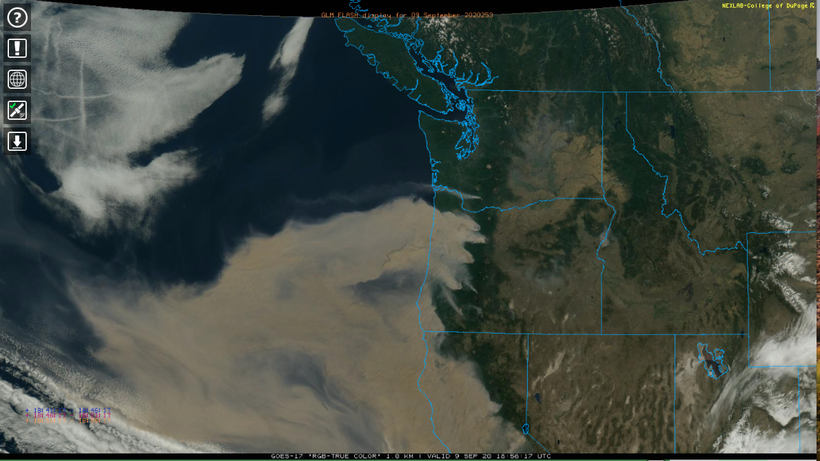
Also, since it's fairly boring around here today.. here's another shot of how widespread the wildfire smoke is in the Pac NW and California. Also jet contrails in the clouds on the NW corner of that shot over the Pacific.
-
Central PA 2020 Fall - The Hope begins
MAG5035 replied to paweather's topic in Upstate New York/Pennsylvania
We're less than two weeks from the fall equinox, it's getting harder and harder for even the H-burg desert to get near that 90 degree mark without having a pretty anomalous airmass around. Looks really nice early next week after the passage of a system Sunday that might finally provide some regional rain chances. Also a chance of some thunderstorms mainly in the LSV tomorrow as well. The 12z Euro is actually quite robust on QPF especially in York/Lancaster counties. -
Central PA 2020 Fall - The Hope begins
MAG5035 replied to paweather's topic in Upstate New York/Pennsylvania
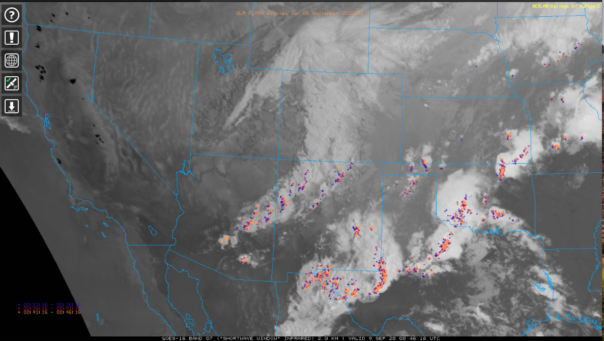
Wow what a loop, if anyone sees this soon you can see the very robust storm in the Rockies wrapping in some of the wildfire smoke from California and Oregon. Insane how big those fires are and how much smoke is being generated. https://weather.cod.edu/satrad/?parms=regional-southwest-truecolor-96-1-100-1&checked=map-glm_flash&colorbar=undefined https://weather.cod.edu/satrad/?parms=subregional-Oregon-truecolor-96-1-50-1&checked=map-glm_flash&colorbar=undefined I'll add in this shortwave IR snapshot. Every one of those black spots in California is a wildfire area, and there's several more further up in Oregon too.
-
Central PA 2020 Fall - The Hope begins
MAG5035 replied to paweather's topic in Upstate New York/Pennsylvania
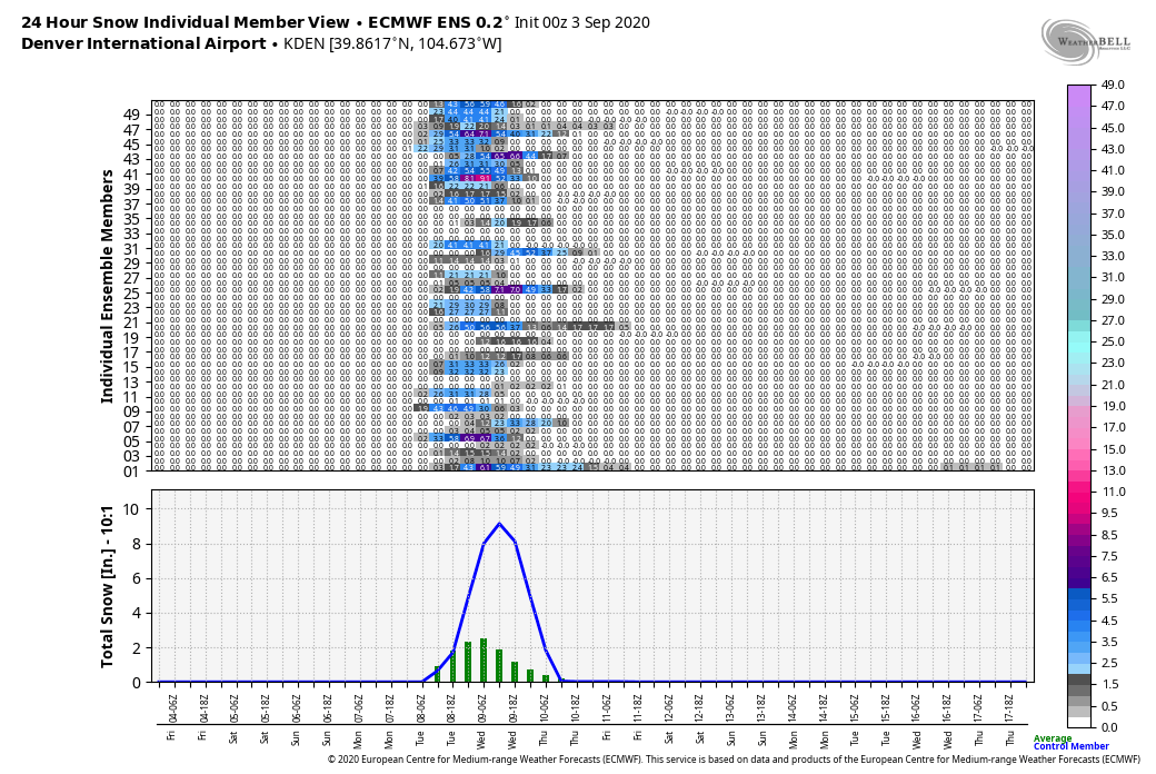
Yea I'm not sure what would be crazier on it's own there, the late 100+ heat or seeing the snow. Obviously the combination of the two things within a day is insane and historic, especially in terms of temp differentials and departures. But honestly the heat wave part of this is likely the more extreme thing. It's relatively normal for the Rockies to start seeing higher elevation snows in September and Denver in fact averages 1.3" in September. It would appear that the only snow record Denver would break looking at what's being forecast there is possibly the heaviest first snowfall of the season. The earliest is 4.2" Sept 3, 1961. https://denver.cbslocal.com/2020/09/04/weather-whiplash-colorado-record-heat-cold-snow/ This article also mentioned the last measurable September snow at Denver occurred September 24th, 2000. So this hasn't happened at all in September in the last two decades. -
Central PA 2020 Fall - The Hope begins
MAG5035 replied to paweather's topic in Upstate New York/Pennsylvania
It'd be nice if some of that thunderstorm activity found it's way down here later on. But in the meantime the cloudcover all day from it has pretty much shut down what was looking like yet another high 80s day. -
Central PA 2020 Fall - The Hope begins
MAG5035 replied to paweather's topic in Upstate New York/Pennsylvania
Lol i could just imagine the “ground is gonna be too warm for accumulation” discussion. -
Central PA 2020 Fall - The Hope begins
MAG5035 replied to paweather's topic in Upstate New York/Pennsylvania
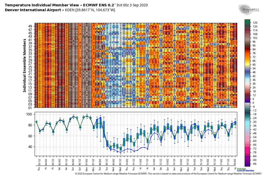
Yup sure do, Denver may have their first snow of the season with that trough dumping into the Rockies. The Euro has been showing that as well. How's this for insane...look at the Euro ensemble output for KDEN. Literally supposed to be 90-100 for a high for a few days right up to the day before it maybe snowing there.

-
Central PA 2020 Fall - The Hope begins
MAG5035 replied to paweather's topic in Upstate New York/Pennsylvania
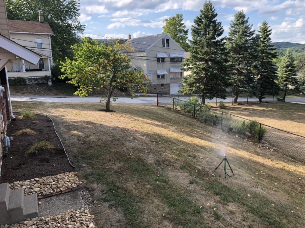
I’d say the yard made a heck of a turnaround in the last two weeks. August 18th Today: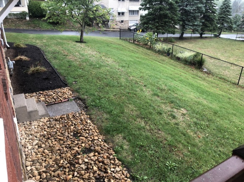
-
Central PA 2020 Fall - The Hope begins
MAG5035 replied to paweather's topic in Upstate New York/Pennsylvania
You must be forgetting our first three months of the year featured cutter after cutter after cutter...after cutter. That's okay I don't blame you lol. We were wet the past winter into the early spring. We would likely have been in a more advanced stage of drought (longer term effects) had the last winter been a dry one to go with the mild. -
Pittsburgh PA Spring and Summer 2020 Thread
MAG5035 replied to meatwad's topic in Upstate New York/Pennsylvania
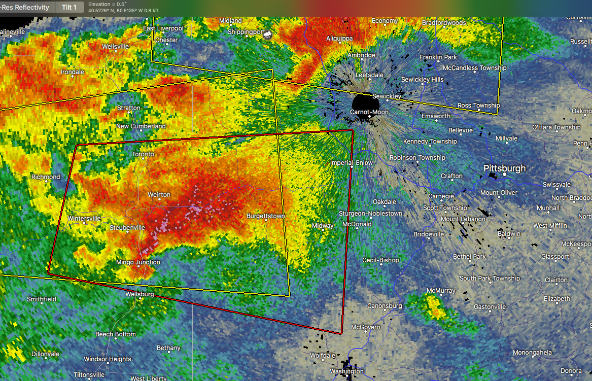
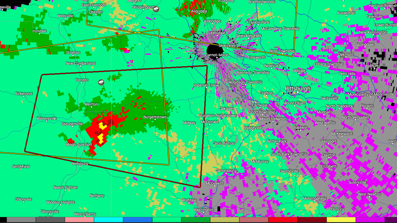
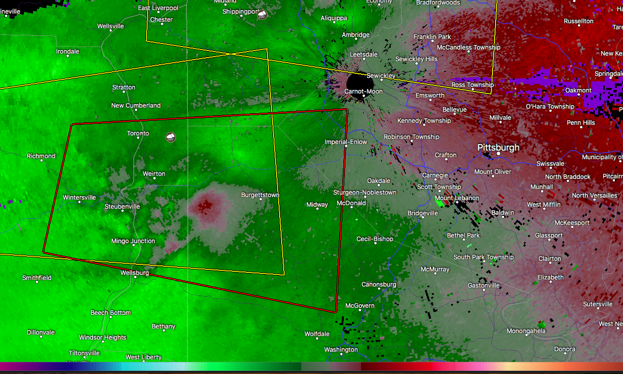
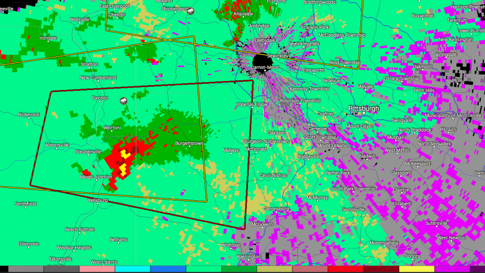
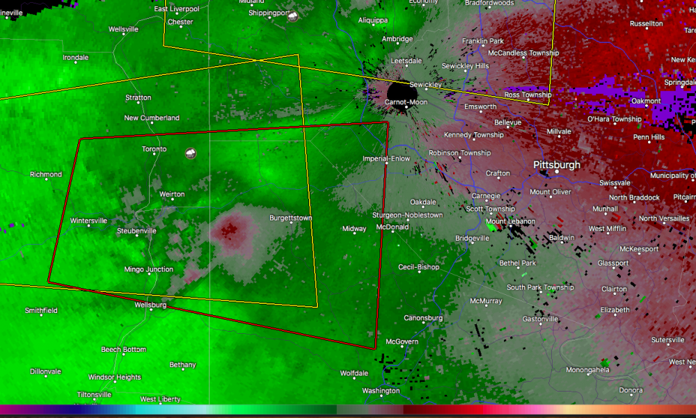
Tornado warning just issued coming into western PA from Ohio, portions of northern Washington and western Allegheny Counties. You SW PA folks got quite the severe setup, at least on paper (Mesoanalysis). Surface CAPEs over 1500 and Mixed Layer capes near 1000 coupled with modest helicity and pretty good shear/lift are putting out EHI values and lighting up the tornado parameter products. I'd be very watchful of that line of storms as it presses into SW PA and also some potential discrete storms esp south of the city. Of more immediate attention, the hook echo portion of the tornado warned storm looks to be taking aim at the southern suburbs of Pittsburgh eventually (Bethel Park, Mount Lebanon, etc). The north side of this cell likely has significant hail in it as well. Velocity isn't showing a concise couplet but the pronounced hook echo is definitely indicating rotation in this storm.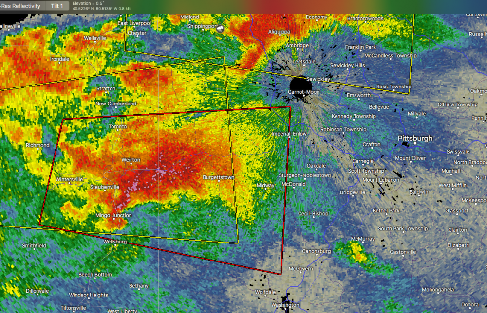
-
Devastating tornado strikes Joplin, Missouri
MAG5035 replied to Hoosier's topic in Weather Forecasting and Discussion
Also, if you go back to the 2nd page of this thread (post 45) you find a poster that quoted JoMo's last few posts before the storm hit.. the second of which saying about the sirens going off. TIme on that post was 5:17 CDT, right at the time of the warning (VTEC31) issuance. 10 minutes later was his last post about the couplet being nearly overhead. Whatever happened to that particular thread (or portion of this thread) where people were posting as the storm was unfolding? I seem to remember that folks might've been watching that first warned cell when the Joplin cell suddenly exploded into the monster tornado signature just outside of town. There's of course those couple chaser videos that show this tornado going from a developing multiple vortice to a massive wedge in about the time it takes for the doppler to make one scan. I know that's one of the many aspects of this storm that fascinates me..practically watching the whole wall cloud drop to the ground in a minute or two. -
Devastating tornado strikes Joplin, Missouri
MAG5035 replied to Hoosier's topic in Weather Forecasting and Discussion
Very glad to hear that you and your family are ok.