MAG5035
-
Posts
5,882 -
Joined
-
Last visited
Content Type
Profiles
Blogs
Forums
American Weather
Media Demo
Store
Gallery
Everything posted by MAG5035
-
Yea they probably should have added a tier of counties to the advisory as the I-80 corridor has been showing it on the ground all afternoon. State College had a little bit on the ground early before that heavy burst of precip moved in. PennDOT being pretty proactive and has I-80 Bellefonte to Dubois as well as I-99 from I-80 to Bellefonte under a 45mph restriction. Probably would've been a Friday evening debacle had there been regular traffic.
-
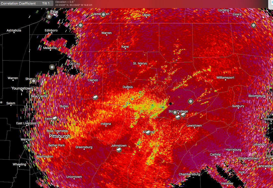
Lol that 2.25 is a bigger single snowfall than I had the entire winter. On the changeover yea the dual pol is really showing it now, and also how the UNV region is hanging on. There is actually accumulating snow starting to show on the overpasses on the I-99 cams all the way down to Port Matilda as well as a crash between Skytop and the Grays Woods exit near State College.

-
How much do you have? It looked like the top of the mountain easily had advisory amounts.
-
Impressive, down to Clearfield's elevation with the snow on the road.
-
It might, you certainly have a good chance of at least staying snow while the heaviest precip of the event is moving through right now. There is some signs of mixing in SW Clearfield county on the dual pol products but I think your pretty established in the snow.
-
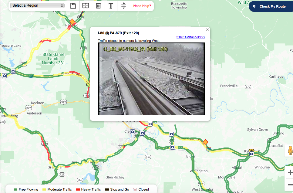
Looks like I-80 at the top of Rockton Mountain is starting to cave.
-
Tryin to mix some wet flakes with this heavier precip pressing in.
-
I think the further south rain/snow line of the Euro ended up being most correct, as we do have some instances of snow on the ground below I-80 this afternoon. Just rain here, but State College has had snow and there is some on the ground on the 511 cams up there and ESE of there on top of Seven Mountains (Rt 322). I-80 from Milesburg west to the Ohio border has varying degrees of snow.
-
It's looking like the snow swath is going to reside above I-80 in the northern tier counties and up into the NY Southern tier. The low has edged north the last couple days just enough that it's going to take the best precip into central/northern PA and bump up the thermal boundary just enough to make a cold rain for most of us in here. Models are pretty dialed in on the northern tier, where it's probably going to be a pretty solid advisory event. I wouldn't be surprised if some of the high ground even cracks 6". Euro still has more of a dip south in the middle of the state, where UNV or IPT could see some snow esp on the front. I think front end snow in those places would depend on if more WAA broke out ahead but it looks like that would also be targeting the northern tier more. This was really close, if the low would've been able to stay under PA this probably could've snowed on the majority of us. The cold was/is there.
-
I agree, if we would have went about this business as usual we likely would have ended up in the same stay at home situation anyways with a whole lot more death and overwhelmed hospitals. I think PA has handled this fairly well to this point and we have stayed off the peak in daily cases several days ago and have limited the spread/expansion of the hot spots in the Philly/SE PA, Scranton/WB, and Pittsburgh metro regions of the state. With that said, I do believe they need to start exploring what "non-essential" sectors they can start opening back up safely more seriously than just talking about it.. which was generally the goal of the legislation that worked through the PA house/senate. PA and MI are two of the bigger states with the highest percentage of UC claims (roughly 20% of the workforce). I think anywhere where one could lessen that tremendous burden on the state UC system by getting some people back to work where it is deemed safe would help with being able to assist other sectors of the workforce that this is going to affect for a good bit longer even with eventual easing of guidelines (travel/restaurants/entertainment/sports/etc). That's also not to mention the small business part of the equation where there still isn't anything in place in terms of UC for self employed individuals. It's been harped on for weeks that testing ability is a major key to getting things started back up and countries that implemented aggressive testing for this right off the bat have been ones that have been able to both handle cases/isolating people while keeping at least some functionality. So it's mind boggling to me that we're still at a point this far into this outbreak where in a lot of cases we can only test folks with more serious symptoms and that's it (and sometimes not even then depending on availability) when in the same breath there's evidence that a notable percentage of possible cases could be from asymptomatic carriers. That type of data is extremely vital to those model projections they use to determine where were at in the spread of the virus and what measures are taken. We've tested roughly about 1% of the population in the US, which is certainly not enough of a percentage to really have the big picture without a lot of assumptions. This is a more of a visualization than a direct comparison... but if we're putting this really roughly in weather terms, that would be sort of like trying to figure out the weather pattern in the US plotting out 1% of official weather stations around the country. You might get an overall picture but your going to miss alot of details.
-
There's been movement of a couple bills in the PA House/Senate to reopen some businesses provided they are able to comply with specific guidelines, and also develop mitigation plans off of CDC guidelines. That main one passed the house and then senate today, basically on party lines. Highly unlikely Gov Wolf goes with that and also unlikely there's enough votes to overturn a veto.
-
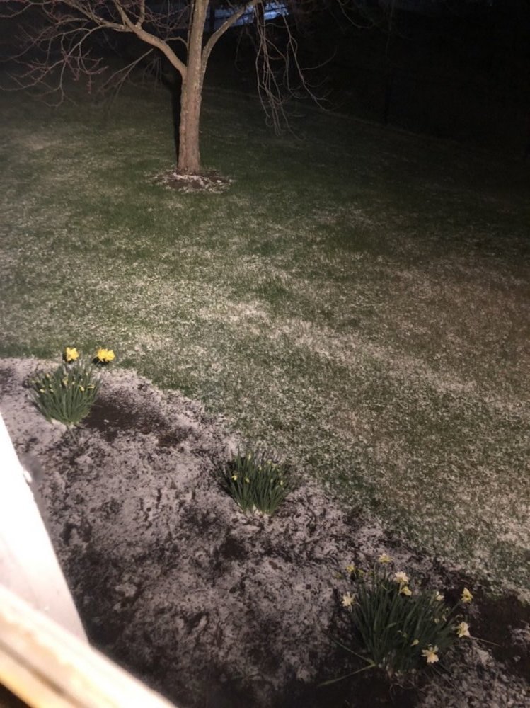
Rain/snow mix and 39ºF.
-
This week is likely to be the last week until later this fall for prospects of the wintry kind in the majority of PA. There's 3 disturbances on the models that have been showing up for this week, with this evening's system being one of them. Another weaker disturbance passes through tomorrow evening (Wed night). This one arrives from the west and it doesn't look like it's going to make it over the western mountains precip wise. But there will probably be another light accumulation in the Laurels and potentially more flakes to be seen in western PA and the immediate central off the Laurels. Friday's system looks like the strongest of the 3. Track of the system is going to dictate how far south any snowfall gets. I'd like the prospects of north-central above I-80 by the looks of things. 0z Euro has come north a tad more where the GFS/NAM reside. 0z GEFS spread has some members with a swath into the heart of PA lending to a more robust snowfall mean into places like UNV (sort of jived with the Canadian), but generally it's swath is running I-80 and above. This could be a solid event for whoever sees it, especially for the time of the year. 850 air in place ahead of the system will be sufficiently cold (-6ºC or so over most of PA prior), which is about 10ºC below average for this time of the year. If the track of the low ends up trending south, so will the prospects of a very late season snowfall with it. Northern PA/southern tier NY is the safe bet right now, and where I'm eyeing this potential to be most likely.
-
Well this happened in the last hour or so. Tack on another 0.2” lol.

-
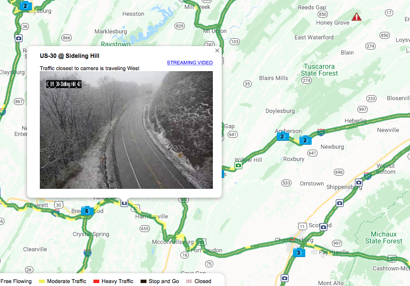
I'd be seeing it if there were heavier precip overhead. It's really light right now and there looked like some wet snowflakes in there but I don't have the rates. Cams in Somerset have snow on the ground and now the Sideling Hill cam east of Breezewood (Fulton Co) on Rt 30 has snow on the ground under that area of heavier precip. If that progresses eastward, some of those ridges along the southern tier further east are probably going to change over. Edit: I can confirm a few flakes now
-
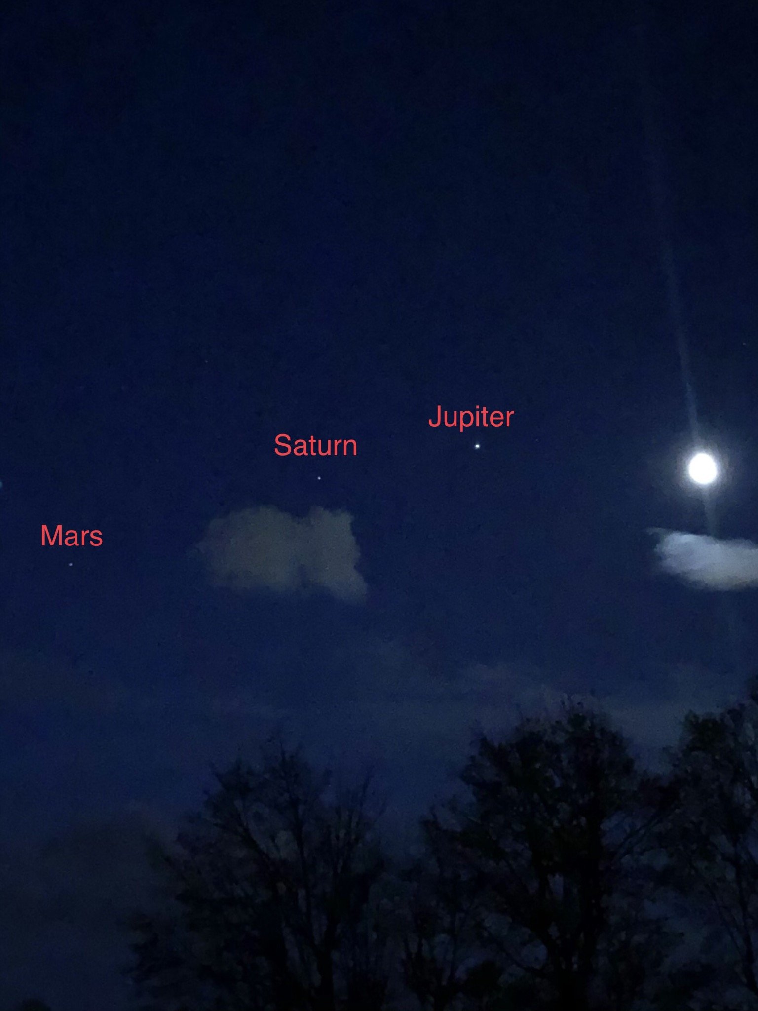
I got this pic first thing this morning, it cleared enough to see the planetary alignment with the moon.

-
Snowing on the 511 cams in Somerset county this afternoon, as well as the MD Chart cams from Frostburg westward.
-
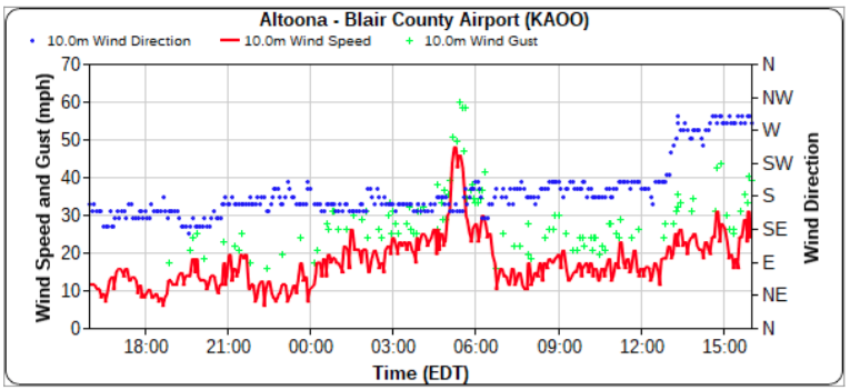
KAOO has had consistent 40+ gusts here and there but this has been quite a non-event here locally today, even post-front. Had a nice severe warned line come through early this afternoon but there wasn't much wind with it. Also interesting on KAOO's meteogram from about 5-6am this morning the airport had a period of winds that were sustained in the 30-50 mph range and a couple gusts to 60mph (max gust to 62mph). There were several power outages in parts of the county this morning but I had nothing of the sort here. That 5am timeframe was around when that slug of heavier precip was lifting up into southern PA heading toward the LSV. Tabular data: https://mesowest.utah.edu/cgi-bin/droman/meso_base_dyn.cgi?stn=KAOO&unit=0&timetype=GMT
-
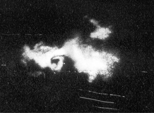
If there was ever a tornado that flies in the face of that theory, that particular tornado was it. That was at the time I believe one of the widest tornadoes ever recorded and it ripped a swath in the woods of Northern Clearfield and Clinton Counties, where it is quite mountainous. I think the only reason it probably wasn't rated an F5 was because that storm miraculously tracked nearly its entire 70 mile path in the part of PA where there literally isn't anything else other than state forest, so there really wasn't anything else to rate damage-wise other than the sheared and uprooted trees. That was during the time when the original Fuguita scale was used. That outbreak featured a setup in western PA that day more reminiscent of what you would see in major plains outbreaks, large CAPE coupled with the proper shear. Certainly the terrain in central PA is much more often than not detrimental in the aspect of having the prime setup for a classic tornadic outbreak. But if you achieve that setup and you have a long tracked supercell/tornado of that magnitude on the ground, it doesn't matter what the terrain is that it's crossing. And that's certainly the lesson to be learned there. Western PA, and especially NW PA where the absolute worst of that outbreak occurred is probably the part of the state most conducive to stuff like that. Why? Because you can achieve that low level southerly/southwesterly flow more readily. There's no mountains to the west that holds clouds in the low levels and/or maintains a stable surface/boundary layer via a cool air damming scenario. You also have to have a favorable track from the parent low pressure system for an organized severe outbreak (outside of MCS and some derecho events), and that's part of why our "tornado season" is typically in that late May-June timeframe. Here's the best image/loop you'll get of the 85 outbreak. You can see western PA cleared out and it's likely the severe parameters were such that it was able to maintain the supercell responsible for the Moshannon tornado. Also not mentioned much in the details of this outbreak is that this also caused several tornadoes in Ontario as well. Radar image of the Moshannon tornado from the old school radar that was on top of the Walker building at Penn State. CTP's writeup on this , which is a good one with all the weather maps of the setup. https://www.weather.gov/ctp/TornadoOutbreak_May311985
-
That's quite a satellite loop: https://weather.cod.edu/satrad/?parms=meso-meso1-truecolor-96-1-50-1&checked=map&colorbar=undefined
-
Yea I was looking at the 3k NAM and noticed the CAPE getting up into eastern PA. With this dynamic setup and a ton of shear, it doesn't take much CAPE in the equation to have a setup for potential spin-ups. The CAPE the NAM has is more than enough getting a ribbon of 1000+ into eastern PA during the mid afternoon tomorrow and thus the tornado parameters are lighting up, which concerns me. This wind/severe potential statewide looks to have two different areas of focus. Everyone looks to get wind advisory type winds from this system (now issued by CTP). Those western higher elevation counties now in the high wind warning have the bigger wind threat from the significant isoballaric component behind the frontal passage (rapid pressure rise) due to the closer proximity to the deepening low pressure moving up out of the lakes. The Sus Valley has the better chance of severe weather which would easily tap down damaging winds aloft but it's also quite possible that it could be windy before the frontal passage as busting into the warm sector is going to mix the boundary layer and still mix down gusty winds. Amount of clearing is going to be something to watch in the south-central but it probably wouldn't take much with the dynamics.
-
I understand not wanting to see anymore snow and such and posting snow maps and etc.. but I mean the above is referring to a possible event in the 72-84 hour range and this has been on a fair amount of guidance in some form or another for the last several days. Tomorrow's storm is going to end up a sub 970 bomb lifting out of the lakes and that's going to carve out a pretty major trough and cold weather for the midweek. The bigger issue I see right now with that following event is it may be suppressed to much. But if it runs a half decent shot of precip north enough to get into PA in that Wednesday timeframe yes, it's quite probable that it could be snow in some places. That's neither wishcasting nor sugarcoating the reality of PA weather during the early spring.
-
Severe threat with Sun night into Monday's storm system going to hinge on how much we bust into the warm sector and the usual cloud cover issues and whatnot... the latter of which I'm not too keen on. CAPE will probably be limited but I can see a line of storms try to fire near the frontal passage and it wouldn't take much to tap down what looks to be screaming winds not too far aloft. Will probably have to keep an eye on the LSV in particular in terms of severe. Either way, you folks that live in the jet stream over there in the LSV should be delighted to know that this upcoming storm probably poses at least a similar magnitude wind event threat as Thursday's system. May not be as long lived but we could be talking similar wind gusts for some portion of Monday just prior and especially after frontal passage. I'd argue the wind potential is even greater but models seem to run the wind max (and corresponding LLJ max) up the I-95 corridor and they have really have then screaming in NJ and NYC/LI. It's still going to be windy regardless. The usual half decent low that runs up through the lakes typically makes for a breezy post frontal regime. A low of this magnitude winding up over the lakes (to 970ish) is likely to bring the wind headlines with it.. perhaps even high wind criteria for some parts of PA.
-
Reporting thundersnow here. Very robust squalls with heavy snow and strong winds.
-
We'll have to watch the kicker system(s) behind the major Great Lakes storm progged to rip up through the lakes region on Monday, possibly in the next Wed/Thurs timeframe. This weather pattern shaping up on the models for the mid-month timeframe is exactly as I feared for about the whole last half of winter.. certainly not too little but definitely too late. We finally have the amp to the pattern with a well placed and very strong western US/Eastern Pac ridge with the highly anomalous eastern trough to go with it. It looks like it would probably be an anomalous enough pattern for mischief in the snowy form with a well placed/phased system. Models today around D6-7ish have what looks like maybe a northern branch wave digging behind a departing coastal that runs a wave of precip through. That'd probably be enough for flakes at least back this way and especially in the mountains, but probably tough to accumulate with a lighter event being progged. The temps/thicknesses aloft are certainly going to be there for any system but surface temps at the lower elevations with the strong sun will always be an issue this time of the year without an incredibly cold airmass or an intense storm system. It becomes extremely hard to get a widespread PA snowfall after maybe the first week of April. Light snow events in early-mid April aren't too out of the ordinary in the higher Laurel's locations, or even here (i've already seen mangled flakes today). But the April 7,1982 event is about the latest one I can think of for the LSV region, and we're getting past mid-month with this potential pattern later next week. The most extreme historical example is the April 28, 1928 snowstorm in central/western PA i've brought up a few times in the past.. that dumped 1-2 feet in this area and more in the southern Laurels. I remember a powerful nor'easter in mid April 2007 had model projections in the 3-5 day range with excessive snows but ultimately ended up only snowing in the high ground of the Apps. You have to pretty much have the stars align for a bigger event this time of the year. But even without any additional snow events, it looks quite cold and unsettled.. maybe not April 2018 cold but pretty chilly.