MAG5035
-
Posts
5,882 -
Joined
-
Last visited
Content Type
Profiles
Blogs
Forums
American Weather
Media Demo
Store
Gallery
Everything posted by MAG5035
-
Yea lol, I actually never added in the few tenths I got during our wintry first 2 weeks of May, so it's more like a rip roaring 16.5" for the season. The real bad part about that is that those two season in the 50s are generally an average winter at this location. A normal garbage winter would be a notable improvement over what transpired here last winter. All the very worst ones in the last 20-25 years or so had at least one event that had a warning snow, or at the worst a few solid advisory events. Never measured anything much more than 2" on anything last year.
-
I'd end up with brown grass that's not crispy when you walk on it.
-
Yea the 6z Euro (and now 12z Euro coming in) was into the Fl peninsula as well and the 6z Euro ensemble low clusters was dead center into FL as well. Track is def not set in stone.. it could certainly end up traversing west more before turning. Conceivably it could even end up in the eastern Gulf, which would really ramp up the regionwide rainfall chances here when it gets picked up. The storm is approaching pretty low latitude wise, impacting the Turks and Caicos and looking like it's aiming more toward the southern Bahamas. It's also moving at a fairly modest 16mph pace. If the storm does go up just east of Florida, that's probably going to set the trajectory for potential direct impacts around here to be east of the Sus River. Directly getting dragged through the FL peninsula is a bit tricky. There's not too much precedent for that track. A somewhat close recent example was Hurricane Irma in 2017 but that came up the western Fl coast and that was a different animal altogether... being a long tracked cape verde Hurricane that peaked before approaching Florida. Personally I think there's a better chance the storm gets on the left side of Fl than impacting into southern FL and curving inland through the whole peninsula. NHC will probably still favor the east of Florida track for now, but there are signs in the models that this cone might have to come west. Like I mentioned the best chance of this system becoming more of a regionwide thing here is if it got under or through Florida into the far eastern Gulf and then picked up. The setup is not such for a NC/SC bound tropical system to track directly through the area. That typically requires downstream blocking to the north/northeast to force the track N or NW into our area.. which we don't have. The influencing trough in the Great Lakes/Oh Valley region will def turn this out, just of matter of how far west the Hurricane can get first. What I think could be being under modeled at the moment is potential precip coming from Isaias interacting with the approaching trough. That type of stuff probably won't be resolved well until the short term guidance can get it's hands on it. There remains pretty big timing differences between the Euro and GFS, with the GFS being way faster. The GFS op really isn't the best for resolving tropical systems to begin with. At any rate, the 12z Euro has the center in the Chesapeake at 108 while the GFS has it out of the US. I lean slower but probably not as quite as slow as the Euro.
-
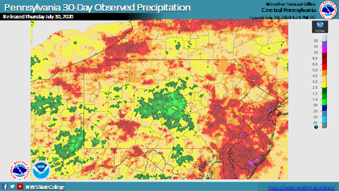
Looks like a pretty decent slug of rain and imbedded storms setting up for the LSV later on roughly from the turnpike south, while diurnal convection fires in NW and northern PA. The D1 beat continues to live on here it would appear... as AOO-UNV looks like they're going to miss yet another widespread rain opportunity tonight. CTP shared these a little bit ago. Barely 0.5-1.5" of rain in the last 30 days right square in the middle of PA. I'd be curious what a 60 day looks like, cuz most of June was just about as dry here. TS Isaias will definitely need to be watched closely for the eastern seaboard as we get into early next week. 12z Euro is much slower/somewhat NW than the 12z GFS (imagine that). Ensemble guidance from both the Euro and GFS seemed to indicate the eastern half of PA could be in line for effects from the western side of the system as the center comes up and curves NE. Heavy rain (and not necessarily a lot of wind) running up through especially from the Sus River eastward in PA is pretty standard boilerplate for a curving tropical system that essentially runs up or just off the coast. Timing of the system and the approaching trough that will eventually curve the storm up will certainly ensure plenty of uncertainty on forecast track for the next few days. Not to mention the storm is currently tangled up in Hispaniola which could pose even more timing/track issues as the storm is trying to redevelop it's center and move generally toward the Bahamas.
-
Widespread storms in western PA, wonder which way they'll eventually miss me tonight.
-
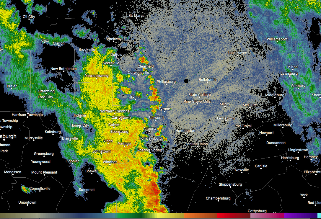
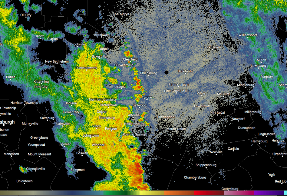
Yea that general area has caught a few heavy rain episodes the last couple weeks. Doppler estimates of over 4 inches this evening have the bullseye just west of Johnstown in what is fortunately a pretty rural area in far SW Westmoreland between Johnstown, New Florence, and Ligonier. Although there have still been significant estimates in the first two of those towns. Its raining some now, and the radar suddenly looks quite active west/northwest of here. Fair amount of thunder and lightning with the stuff near and overhead now so could be noisy if the other stuff makes it here.
-
On the north side of town of course. I've had a few doses of rain the last couple days but definitely not enough. And of course same deal tonight with the real heavy stuff just south of town. Hopefully some of it bubbles up this way. On that note I'm getting rather concerned about the training going on in the southern half of Cambria (Johnstown and surrounding communities). Already flash flood warnings out and 2"+ on the doppler estimates.
-
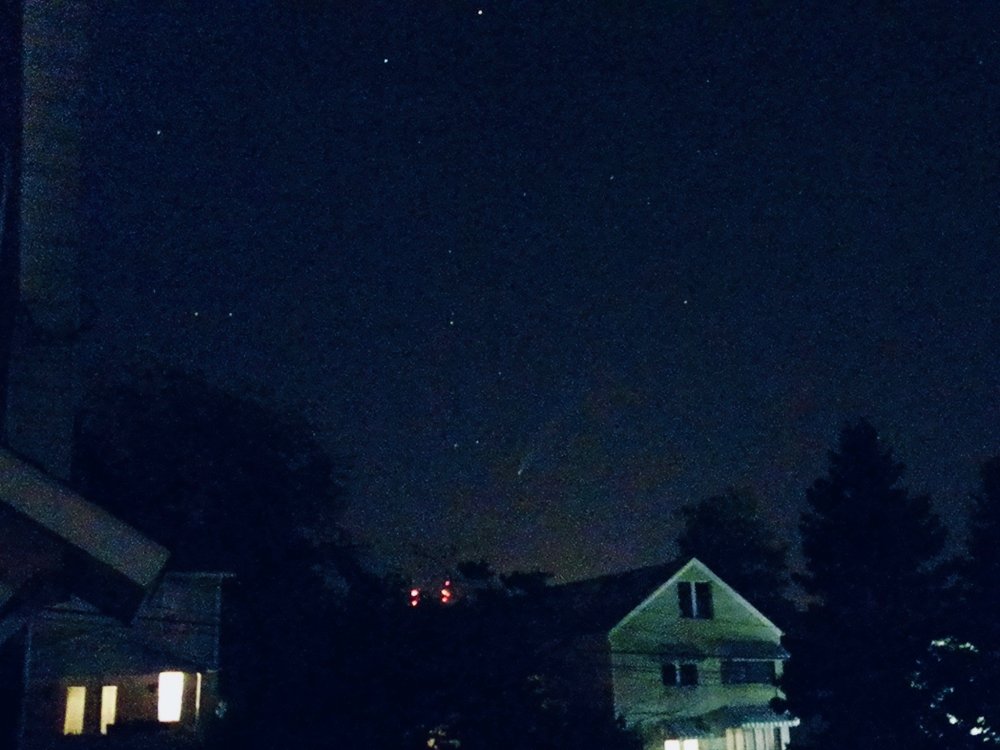
Has anyone seen the comet yet? I managed to get a pic of it Friday night from here at home. Not the greatest with an older digital camera and no tripod but still pretty cool.
-
Meanwhile I just noticed Tamaqua has incoming, again lol @Voyager.
-
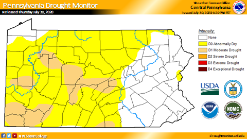
I'm pretty much within the edge of the D1 zone now. Doesn't look like tonight's action is getting here either, with a split in the thunderstorm activity poised to go north and southwest of here. On the drought monitor's national map, the area of drought conditions in PA is labeled as a short term drought.. which would indicate despite it being very dry in a lot of the area that the drought hasn't progressed to one that has adversely affected the water table, reservoirs, etc.
-
Unfortunately overall it looks like we will remain in this type of regime for perhaps most of the rest of the month. It won't be wall to wall max heat but the periods within the next 8-14 days that are "cooler" are still likely to be at least somewhat above average.. which is still hot this time of the year as we're pretty much within our hottest portion of the year the next 3-4 weeks. We've been due for that wall to wall hot and dry summer July/August, although I guess some folks east of the Susquehanna haven't been all that dry lately. As for today, saw that CXY and MDT are back up to 99ºF again after falling to 97 briefly. Two weather stations on mesowest up over 100ºF (101 near Shippensburg and 100 near the MD line south of Gettysburg). Mid to upper 90s are pretty common today in the south central, especially near and west of the Susquehanna and even back here to the eastern Allegheny front where 94-95ºF readings look pretty common. Thunderstorms have fired off of Erie a few hours early by the looks of short term guidance, esp the 3k NAM.. which could allow whatever organized line that materializes out of OH to press further into the central counties early this evening.
-
I actually got a half decent downpour in the middle of the afternoon, probably a couple tenths out of it. Gotta start somewhere I guess lol.
-
Looks like the direction of the day for the rain to miss here today is north haha. It did rain a little bit last night, but what was left of what really looked like a promising area of downpours probably put down 0.05-0.1" tops.
-
Update: I might've spoke too soon. Radar's really breaking up locally with some new stuff that fired east of here and heavier action to the south.
-
Safe to say this is probably making it off the mountain tonight, finally. Or in winter terms, miss the big coastal low and get some weenie ULL snows.
-
That region of the Laurel's has definitely reversed that trend in the last few days, especially just south of JST in parts of Somerset County as we've had a more favorable setup for pop up afternoon storms. One of the first places they fire on hot/humid days around here is typically along those ridges in the Laurels. The late afternoon storms that triggered a flash flood warning in a portion of Somerset earlier (couple spots of 3-4" on the doppler estimate) were on the heels of the same general area getting a similar blob of slow moving storms and scattered areas of 2-3+ totals on the doppler estimates just the other day. Meanwhile down here, no dice again this evening. All around and not here. My yard is still in ok-ish shape, but we need hit with something in the next few days.
-
I’ve been feeling that struggle the last couple weeks haha. My location has missed out in all directions on all the daily storms... although the blossoming radar up the mountain from here might suggest the weather may have other plans this evening for a change.
-
Lol that storm that's been sitting mostly over Gettysburg is basically thumbing it's nose at @Cashtown_Coop's toasted backyard.. though looks like it's trying to reach there.
-
The interesting thing about this run of hot weather so far is we are achieving widespread 90+ on what has been a generally a pretty solid northerly flow the last few days. The good thing about that is the source region is obviously much drier than a more typical southerly or southwesterly flow would be with drawing the humidity from the south. The result is MDT at 93ºF currently with a 56ºF dew point (29% humidity) and a heat index value of only 91ºF.. for instance. So it's certainly a stretch of hot weather but it definitely could be worse. I suspect humidity will be increasing the next few days as flow reverses, which could help for more thunderstorm chances. We'll still be in the same hot weather regime with similar temps in the 90s, so as humidity goes up we may see some air quality/heat related headlines needed for the urban areas in the Sus Valley.
-
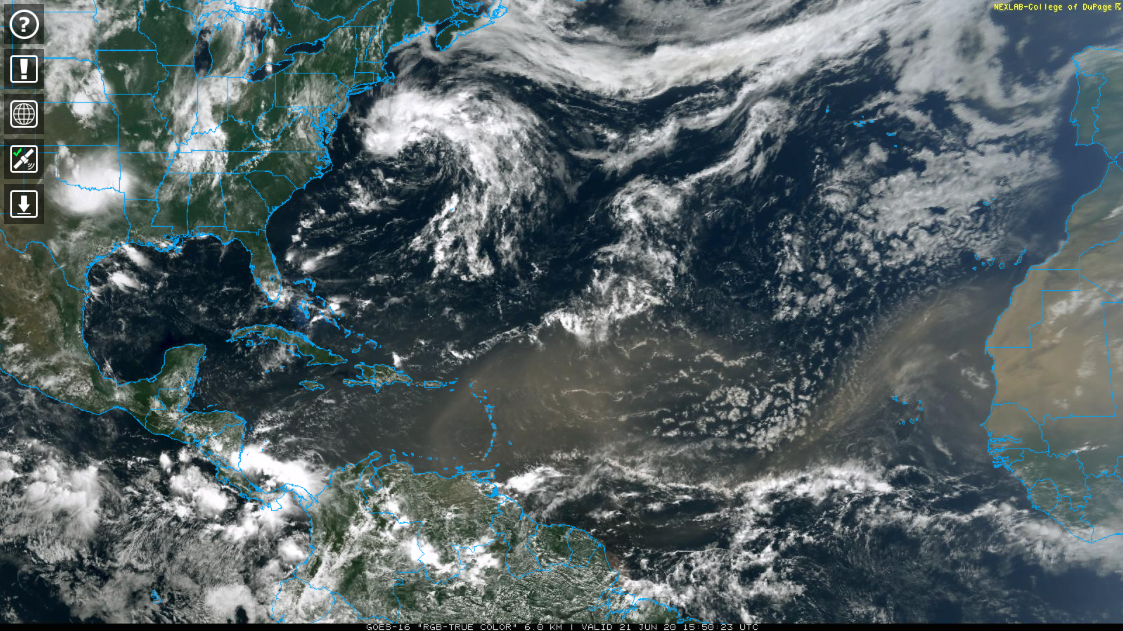
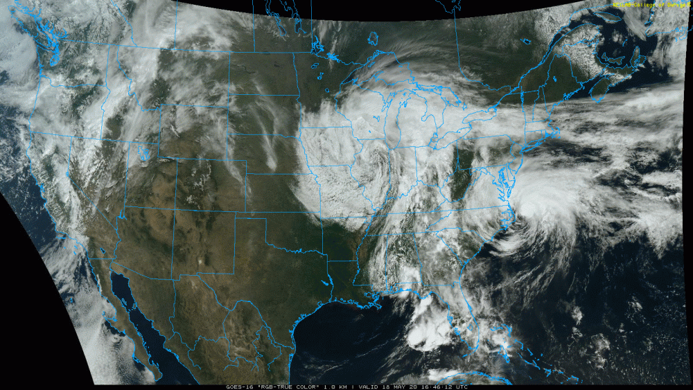
Speaking of dry weather, that Saharan dust that has been all the rage in terms of weather phenomena the last several days is clearly visible on the satellite.

-
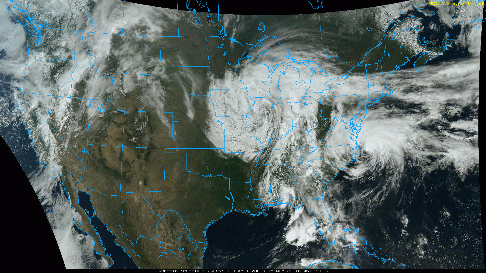
Pretty impressive miss for the local area lol. Arthur sliding east up the coast and out and the cutoff low that is progged to slowly drop down west, and then under us. Quite a satellite presentation. You can even see a bit of another counter-clockwise spin in Southern Alabama. LOOP
-
Dang a lot of mid 80s in the Sus Valley this afternoon, what a difference a week makes. Next week looks wet, that potential tropical system off the Florida coast will have to be watched for interaction with the cutoff low that's progged to sit around a good chunk of next week.
-
Lol, mixed rain and snow with this latest shower coming through. Sure is a miserable day trying to finish the lawn.
-
Looking over the stations that CTP gave numbers for record minimum highs on.. MDT at 46ºF beat theirs by two degrees, Altoona by 1 (40ºF), and IPT (46ºF) and Bradford (34ºF) tied their record values. Browsing the Laurel's stations on the mesowest site, JST and a couple of the stations reporting in Cambria/Somerset barely got above freezing... while a few stations in the Laurel Ridge area near Seven Spring's did not go above freezing at all. What's really amazing about these min/max temps is the fact that it was achieved on a day that had a fair amount of sunshine in between the clouds/snow showers. Just shows how cold the airmass was. And it even ended up that the core of the 500 low and -40º 500mb temps did in fact only swing through upstate New York/southern New England (hat tip to the Euro).
-
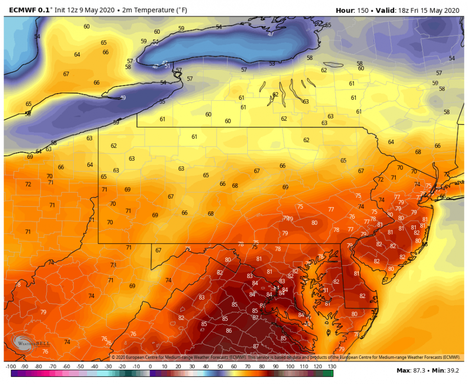
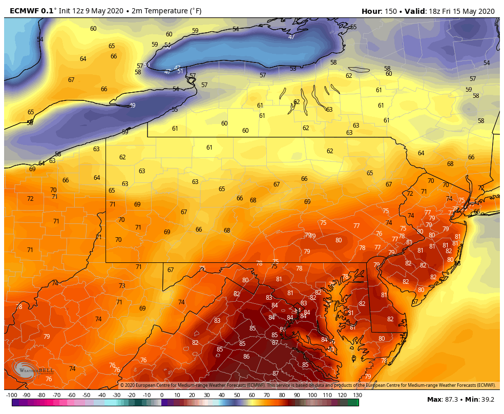
While there's some rain around that could screw this up, this is what we're potentially looking at for highs this coming Friday currently. There's going to be a few more cold nights to get thru the first half of this week though.