MAG5035
-
Posts
5,882 -
Joined
-
Last visited
Content Type
Profiles
Blogs
Forums
American Weather
Media Demo
Store
Gallery
Everything posted by MAG5035
-
100% chance of precip here tonight, plus some early fall foliage lol.
-
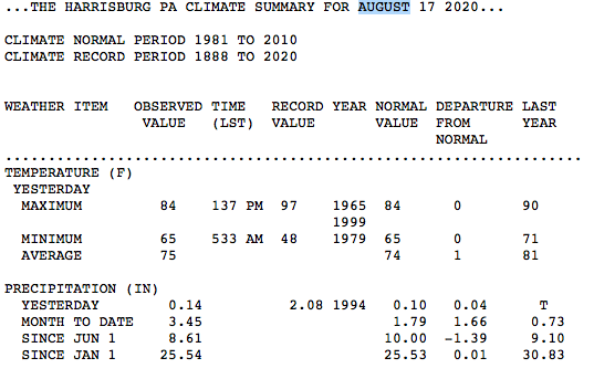
Which climate station has a double digit deficit over 3 months? Any departure like that in this region is pretty severe. That would be like literally having no precipitation for 90 days for most areas in this region. I know MDT has been pretty dry but certainly not to that degree. The precip departure in the monthly climate summaries from May/June/July were -1.90"/+0.21/-3.26". So that's pretty sizable (especially July) but not double digits. That's also not including Hurricane Isaias and those couple wet days either side the first week of August which has MDT at 3.45" for the current month (already running slightly above August's 3.2" average). That puts MDT departures at -1.39" since June 1st and -0.01" since January 1st. Likely why the drought monitor's D0 zone barely gets to the river in the Sus Valley. Those are pretty ordinary numbers.
-
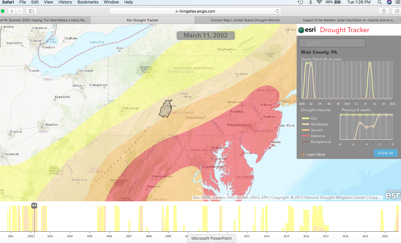
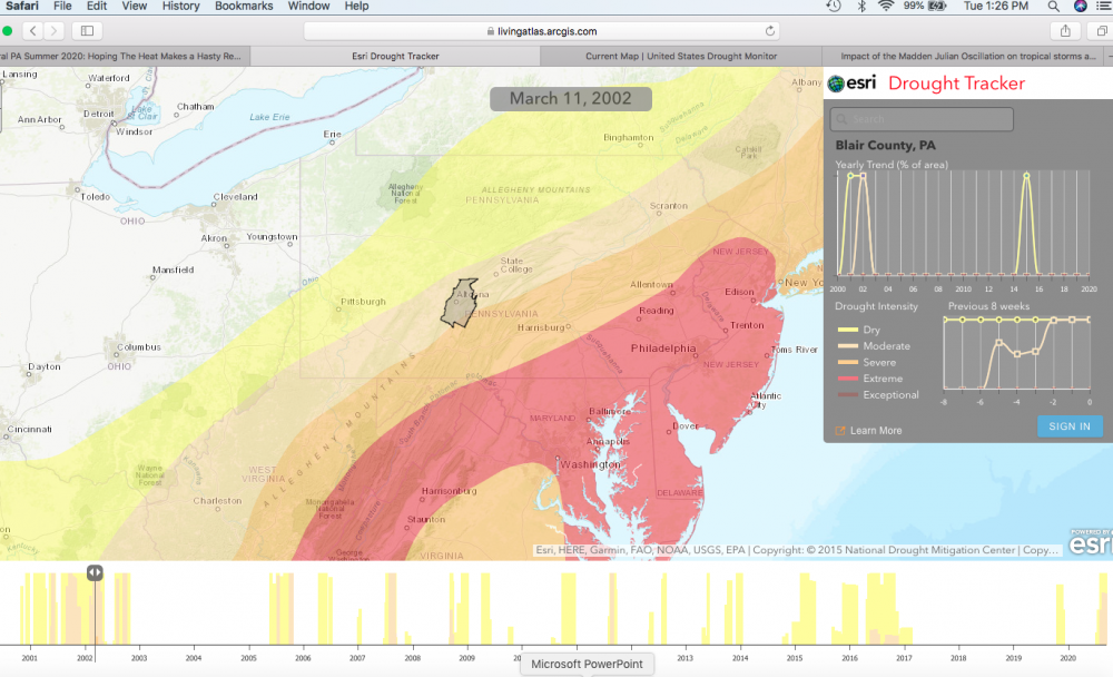
If you click that graph on the bottom it'll actually change the map to what it looked like down to the week. Most of the Sus Valley (and no one east of the river) currently isn't even in D0, if you really want dry click around Mid-March 2002, a good portion of the lower Sus Valley was red (extreme D3). Guess I never realized how dry that non-winter was in 2001-2002. As dry as it's been for well.. most in here, we're still in what would be considered a short term drought.
-
The major theme last winter was certainly not a lack of opportunities, as it was fairly active storm wise. It was a major persistence in the storm track going north/northwest of PA as we came into the short term and then the reality of the event itself. Was sort of why models like the GFS gave us practically a 150% of normal snow season in digital snow in it's mid range. The big problem was the overall pattern vs what the mid term models were trying to do when they did try to give us an event far enough south for a snow event. Going practically the whole JFM period with a hyper +AO and an unfavorable West/Pacific was just a major detriment for our region to track a low south of the mason-dixon OR score notable frozen on events that put a primary west of PA due to a lack of arctic air availability via CAD. I don't really recall the NAM being notably horrendous last winter. It's better with mesoscale features but one has to be mindful that it can be a bit, overzealous at times with it's output on said mesoscale features. A lot of the heartbreak happened before we really got into NAM range as mentioned above. We go through rough patches in any winter whether it's a good or bad one overall. Last winter was that one that just was a wall to wall disaster for this region. Once you got to about the US 6 corridor in northern PA and up into interior NY State it was a different story. Ugh, been trying to forget last winter lol. If anyone's actually wandering what I'm thinking about this coming winter attm since I'm on the topic, well.. I'm approaching it with cautious pessimism right now. I'm seeing some potential La-Nina influences that may come into play as we've been running cool in the ENSO region this summer (especially in 1+2 and 3). It's still considered "neutral" right now in official terms using the 3 month average but SST anomalies in the whole ENSO region overall have def cooled some the last couple weeks. CPC has been putting a 50-55% likelihood of a Nina developing this fall into the winter. I think it would be a reasonable bet to say we're heading toward a winter that's a cold neutral or weak La-Nina. Personally, I'm more concerned about precipitation than temps. A more traditional nina-type winter setup is more dominant northern branch and not much southern branch action. Northern branch stuff that produce a lot of our lighter, advisory type snows was practically non-existent last winter, so I think that could be a net positive compared to last winter. I think the cold will be there, at least more often than last winter. Having such a persistent +AO regime return once again for a second winter in a row is very unlikely. What happens with the northern Pac and the MJO will have also have a major say in things. Having an actual wintry period in December has been somewhat of a lost art form in our region the last few years, so I'd say we're due for that. Ninas can be early starters if we in fact have one late in the fall. Just some way too early thoughts, the heat and the daily precip misses are getting old.
-
Torture
-
Probably another 7+ days of dry weather if that rain doesn't manage to get here today/tonight. No pressure or anything lol
-
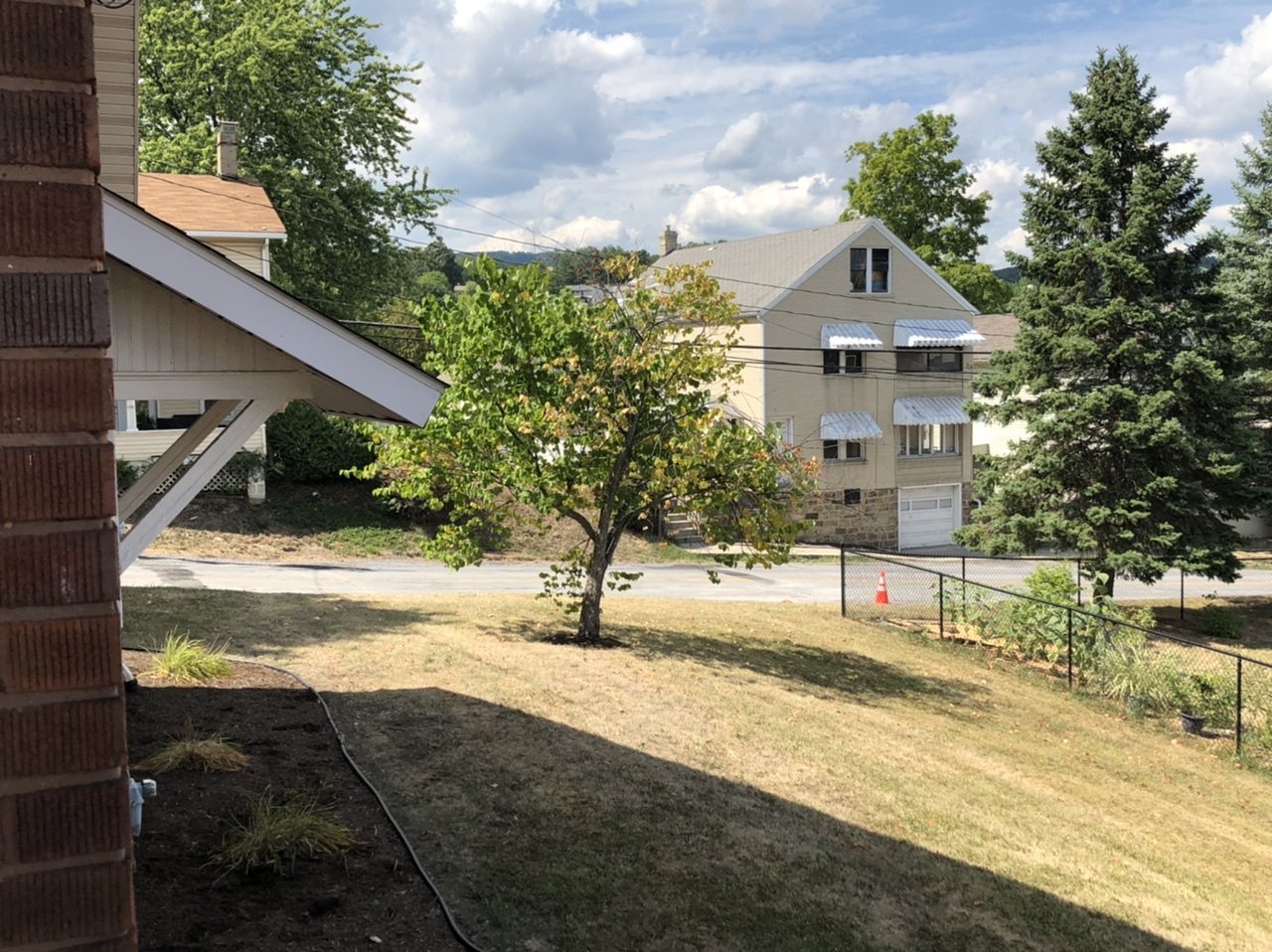
The areal precip would be each county-wide average that is likely derived from their products/maps that estimate precip. So while the overall average on a county is a certain number, there can be portions of that county that actually saw less or more than that number. Centre county has been well, dead center in the driest conditions all summer so definitely no surprise that county is running significantly below average. In this county (Blair) I can pretty much assure you I've seen nowhere near the 3.7" of precip in the last 60 days in my neighborhood.

-
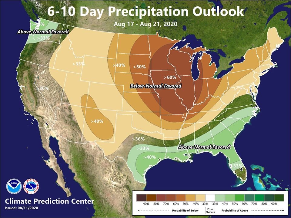
CTP posted pretty much that kind of an anomaly map yesterday for the 6-10 day. Looking like a frontal passage at the beginning of next week will send a cooler regime into PA for a good part of next week. They also just posted this one not too long ago.
-
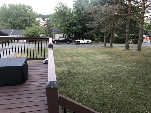
Lol, probably accurate. And while I wasn't home to see it today, we finally did have a round of thunderstorms come through. It was enough to get a touch of green back into the lawns in the neighborhood for now.
-
I was just about to say there looks like some pretty feisty storms in and around Harrisburg.
-
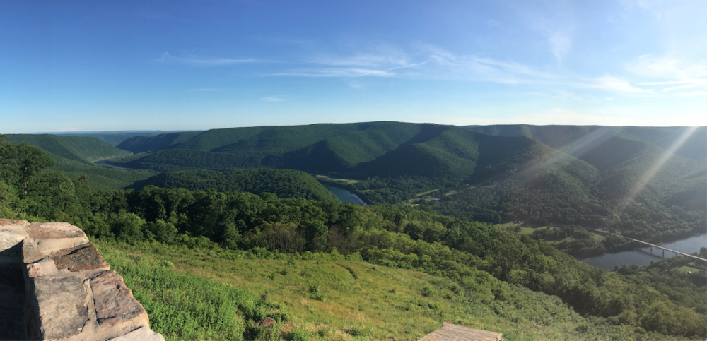
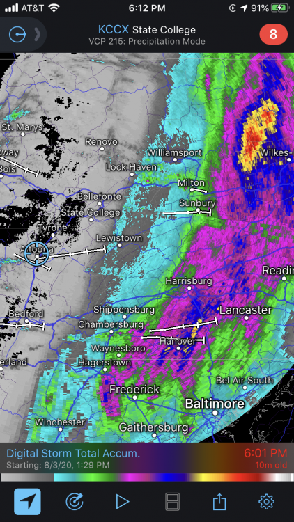
Actually the latest stage at Williamsport for the west branch of the Susquehanna is a straight 0 ft now haha. Further upstream the gauge at Renovo is reading below zero (-0.2ft), which simply means the river level is below what the gauge station's elevation for 0ft is. Either way, that is really low. Speaking of which, here's a picture of this crick from the Hyner Lookout near Renovo I took in 2015. I think that lookout is something like 1300' in elevation above the river. I haven't been up that way in awhile.
-
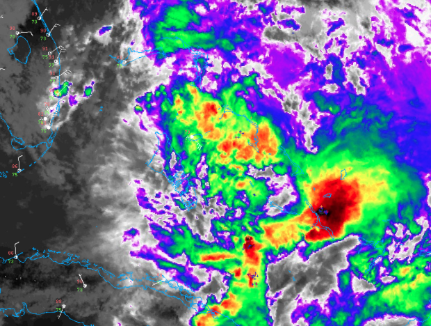
What an awesome visible loop of the progression of this storm today. It probably had a quicker trip up I-95 than any beach traveler has on the weekend. https://weather.cod.edu/satrad/?parms=regional-eastcoast-truecolor-200-1-50-1&checked=map-glm_flash&colorbar=undefined
-
Hi guys, I hear it rained in some parts of the state today It took all day but I’m finally getting some pity rain that may keep some of my lawn on life support.
-
Those models may have better at picking out the interaction with an abnormally strong jet referenced in the 5pm NHC discussion that's going to help rocket this thing up the coast likely mostly intact. 18z Euro 850 winds on the NE quad of the center have a max of 90-100mph all the way up through LI into SNE. The setup is going to allow the potential of the majority of that to be tapped on the east side. As I said earlier, if the core of the storm finds its way into some part of the Sus Valley.. it probably will come with a few hour period of higher winds that perhaps top TS force. As it looks now I think most of this potential just misses the LSV and catches SE PA. This storm is likely strengthening at the last moment bc the shear that has been a detriment pretty much the whole time has weakened, as noted in the update disco from NHC. On a related note.. a lot of non-tractor trailer traffic I saw on I-80 today was in the form of bucket trucks of various utility contractors heading east.
-
The torch has been passed over this way for the Tamaqua split haha.
-
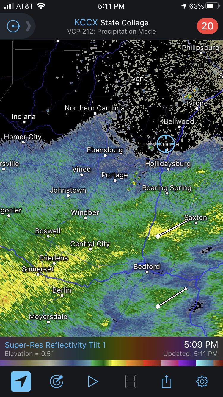
Haha real good time for the CCX Radar to go down.
-
I generally agree. It's hard to tap what is usually high winds aloft on the west side in this type of landfalling setup. Traditionally you would need the center going in west and getting into the more banded eastern side that has the full southerly/southeasterly tap of the jet bringing it northward. However, the actual core of this system is expected to hold together very well as it's drawn more rapidly northward after landfall, and one that stays fairly intact can deliver some decent winds. If the core ventures it's way west enough to fly through a bigger portion of the LSV tomorrow, there could be a few hour period that sees at least some TS force gusts with the passage of it. Or what at your house would probably be referred to as a light breeze. This was in the NHC discussion, although yea that would apply more for the immediate coast.
-
Lol since we're into winter references, this is like watching the Sus Valley locked in for a sure 18-24" while hoping I scrape together enough to verify an advisory. If that early stuff ends up all east of here I might end up being pretty well cooked for seeing much of anything out of this whole event.
-
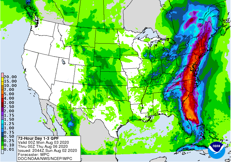
Adding in this afternoon's WPC QPF graphic for comparison.
-
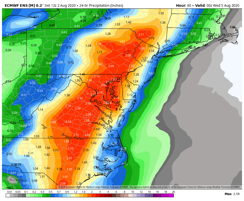
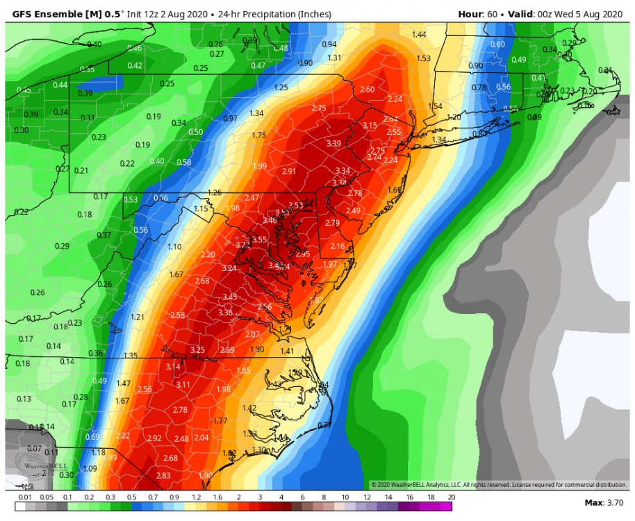
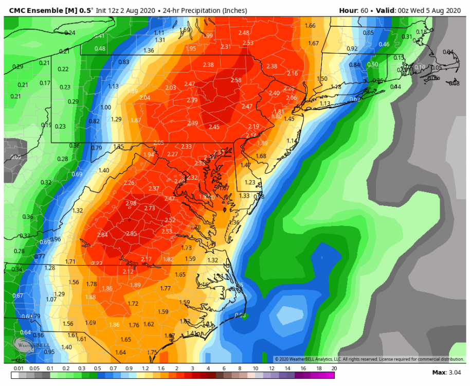
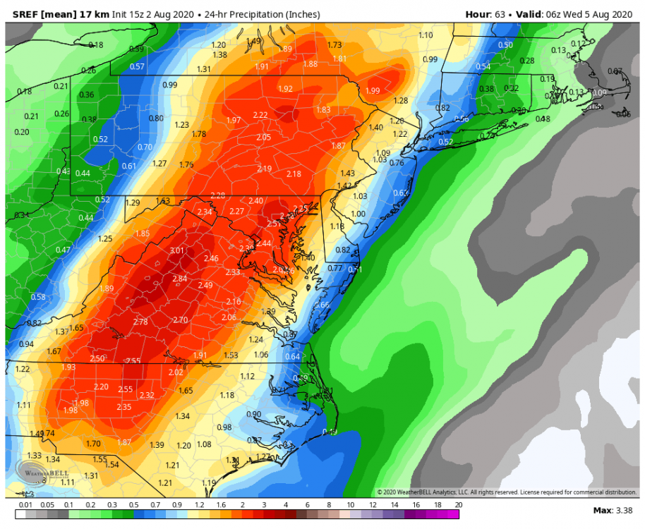
I definitely don't think you or Cashtown are going to miss out on this. The primary issue is starting to settle on position of the heavy rainfall axis as well as overall extent into central PA as models are starting to dial in the track for the most part. The whole Sus Valley should be pretty well into this for a solid rainfall. The only question there for me is how much of the actual core of the center gets into SC/SE PA, that's going to determine how far back those excessive 2-4+ totals get. The central counties where I'm at that encompass the JST/AOO/UNV corridor are going to depend on early development of deform precip as the system interacts with the pressing front. 12z Euro has this and thus gets this area into some solid but not overly excessive rainfall while at the same time having a really tight area of excessive rains, maybe catching Philly at best. GFS/GEFS is tighter with getting stuff back into the central counties, but more expansive with the excessive rainfall into SE PA east of the river in the case of the new 18z GFS. Falls off very rapidly west of the river with the main push. 12z Euro op had more of an expansive preceding precip shield. Early look at the 3k NAM gets the shield back to JST/AOO/UNV. Setting the farther west boundaries of the QPF axis are Canadian and SREF ensembles, aiming the axis more squarely at MDT and having much heavier rainfall back into the central. A look at all the major ensemble means show the biggest bust potential will be in the true central. For the record, I'm leaning the Euro look right now. These are 24hr precipitation total means. GEFS EURO EPS

-
Man if this coming winter presents even half the missed precip opportunities this summer has had around here I might end up in the Panic Room before February lol.
-
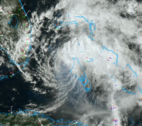
I'd be willing to bet Isaias will not be a hurricane at the 5pm advisory as it certainly doesn't look like one currently. Satellite presentation is a mess this afternoon with warming convective tops pretty much routed off the center of circulation, which can be clearly seen emerging North Andros Island on the visible. It's very hard to make heads or tails of anything on the infrared imagery. This is definitely not a hurricane right now.
-
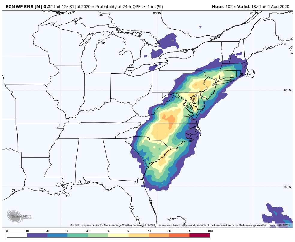
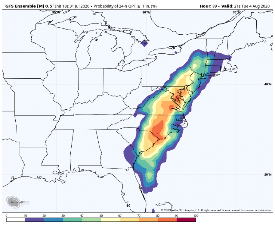
Looking at ensemble guidance, the 18z GEFS and 12z Euro EPS are in fairly good agreement with swath of heavier precip probs (an inch or greater in this example) with GEFS perhaps a tad east of the Euro.

-
Yea lol, I was being semi-sarcastic. I do have some parts that are completely roasted but a good part of the yard is still salvageable. It just needs to rain like now.
-
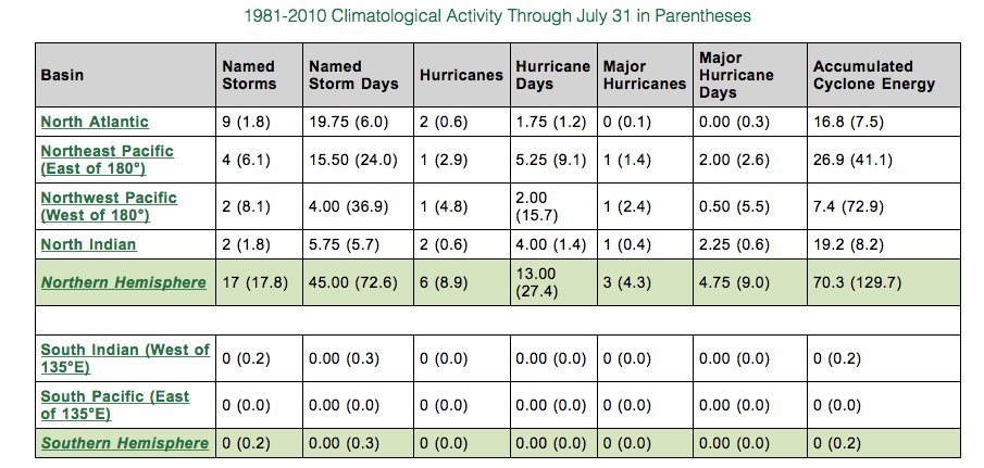
Yea its hard to believe we're already up to "i" on the hurricane name list although we wasted the first several on minimal tropical storms that were of minor consequence or a non-factor. I've always compared recent active seasons to the ones of the pre-satellite era with a grain of salt. The 1933 season is still second behind 2005 with most named storms (20), and that was well before satellite and aircraft recon. Imagine how many more named storms there could have been if the technology to name any warm cored and/or subtropical swirl in the Atlantic Basin was available. At any rate, before Hurricane Hanna and Douglas in the Pac that just missed Hawaii last week, all the tropical basins had been extremely quiet and below average when it comes to ACE (accumulated cyclone energy). The screen shot table below shows the tropical activity in each sector vs climo (in parentheses). Both Pacific Basins are notably behind where they normally are, especially the NW Pac. The Hemisphere as a whole is below normal right now for tropical activity. The Atlantic Basin will probably be picking up some of that slack the next couple weeks. http://tropical.atmos.colostate.edu/Realtime/