MAG5035
-
Posts
5,882 -
Joined
-
Last visited
Content Type
Profiles
Blogs
Forums
American Weather
Media Demo
Store
Gallery
Everything posted by MAG5035
-
Doppler estimates are about an inch or so around here the last 24 hours, which seems reasonable I suppose (not including the line of storms Thursday). We've had several rounds of showers and downpours the last two days. We'll need a good bit more to improve the longer term deficit over the last couple months but this is def some significant short term relief. Its got most of the lawn heading back green.
-
Starting to lose some of the brighter stuff. In the thick of it here now and it's a nice moderate rain.
-
A washout this afternoon, and looking like a washout this evening as well. Wettest day all summer and it couldn't have come soon enough.
-
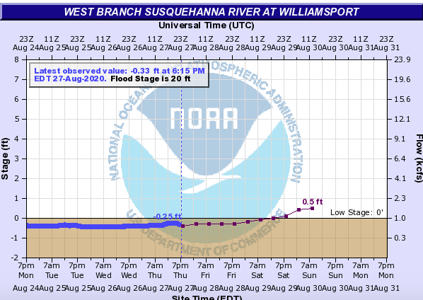
Better watch out, there's a historic river crest brewing on the west branch haha.
-
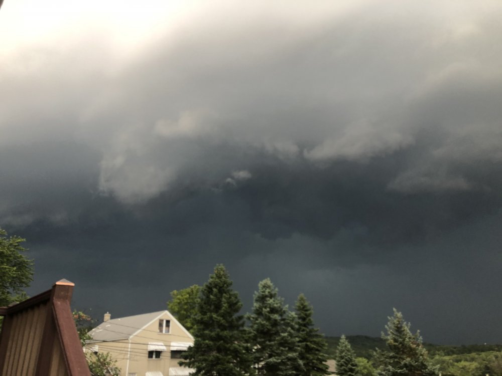
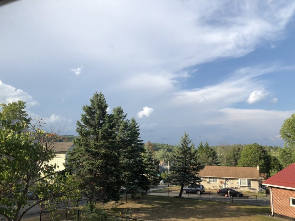
Wasn't too serious, pretty decent gust front before the rain really started and some half decent winds.. and a nice downpour for a change. Temps all the way back to 66. I think this was literally the first severe warned thunderstorm I've had all summer here.
-
Update: Holy F
-
Normally I'd look at a radar like this and think heh it looks pretty stormy later. After this summer I'm looking at it thinking "Wonder how it finds a way to miss us with a light shower at best". At any rate a new severe watch has been issued for most of the central from the Susquehanna westward.

-
The GFS/GEFS really doesn't have a lot of QPF either, it kinda loses the remnant low of Laura on the prog with the northern branch low showing. I've seen Laura's impact here as more of an influx of it's very humid tropical airmass and the potential for heavy downpours with thunderstorms that develop. It's not looking like any kind of significant intact area of heavy rain. The pressing frontal boundary is also going to draw up it's moisture as well but the focus on that has been more on western PA.
-
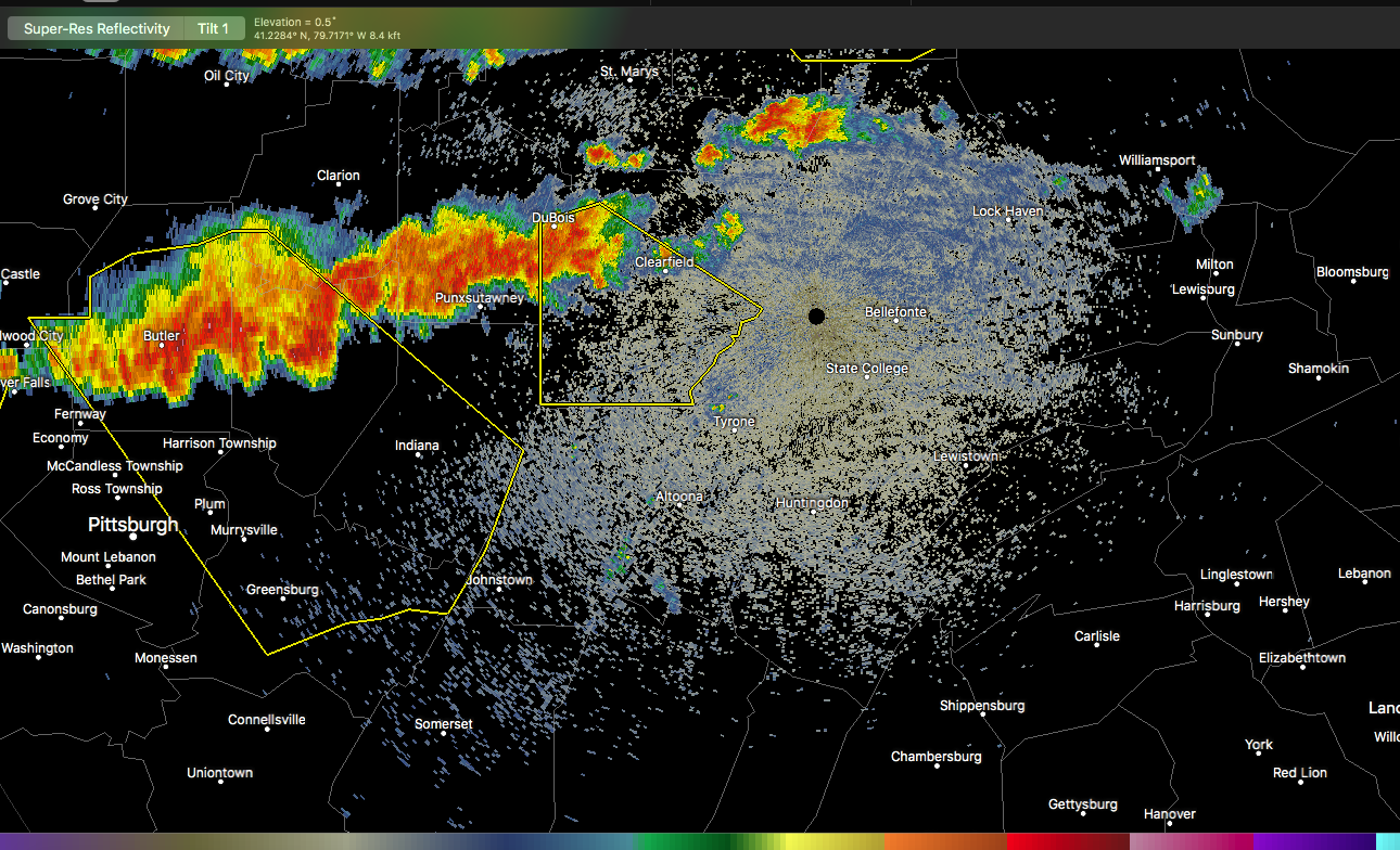
Most of PA is in a slight risk for severe weather today, with an enhanced risk in NE PA and a hatched wind threat area in neighboring NY/NJ/CT . The enhanced risk/hatched wind zone kind of shifted northeast a tad from when I saw it last night, so most of us in here are looking at a general slight risk day with ample CAPE. The better shearing is farther north in NE PA and above, where multiple thunderstorm modes (supercellular and bow segments) are in play and actually occurring already. We could see some pop ups and clusters this afternoon, and downdraft CAPES are quite high, so wind is probably the biggest threat in anything severe in our region. Edit: Mid level lapse rates are also somewhat elevated as well, so some bigger cells that pop up could have some decent hail too.
-
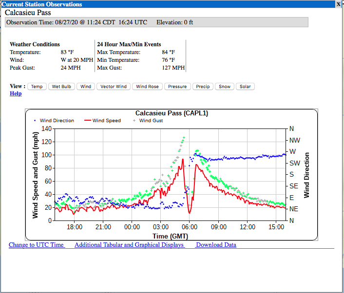
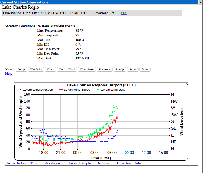
Cameron was starting to get storm surge flooding before dark yesterday prior to the primary bands of the hurricane even arriving there. I'd say NHC's wording was probably prudent there. Heck the Lake Charles NWS had evacuated handing over duties to Brownsville NWS during the storm. I can't really speak for the layout of things having never been down there, but it seems the hurricane came in a bit on the right side of the cone, landfalling directly on Cameron and going straight up getting Lake Charles into the northeast eyewall. It had been looking like the eye was going to go in near the border/Port Arthur, which would have sent a longer southerly fetch up that Calcasieu Lake into LC on the east side of the system. The eyewall came in at Cameron and went directly at LC, which the main storm surge push probably didn't have enough to get what 30 some miles up to Lake Charles without a longer term fetch piling water. That would be my speculation. That's a function of all that marshland in southern LA, it absorbs storm surge flooding. I'm actually pretty impressed that Lake Charles reported a 132mph wind gust and near 100mph sustained before the station went out, and they were still in the northeast eyewall at the time. The station just west of Cameron stayed online and got a 127mph gust. That's about it for ASOS quality stations in that immediate area where the eyewall tracked, so those are pretty impressive obs for the limited obs that are down there. Both the Lake Charles and Fort Polk radar all the way in central LA went out at basically the same time last night and are still offline. That's probably an indication of how much of LA doesn't have power. Lake Charles Calcasieu Pass (just west of Cameron)
-
Ugh it's not a good outlook for most of a lot of those communities. I hope the ones in Port Arthur, Lake Charles, and Nederland evacuated. The way this storm is moving at a half decent clip it's going to take hurricane force wind gusts way inland. Hurricane hunter's are finding pressures in the 930s now. Like I said in my last post, this is probably coming in peak intensity. It's sort of looking like the situation with Hurricane Michael back in 2018. As bad as this is going to be on the coast and well inland for those that get into the core of the storm, the fact this thing is going to split the uprights and landfall in a pretty rural stretch between Galveston/Houston and New Orleans is a miracle. Couldn't imagine this coming straight up Galveston Bay or into SE LA below NOLA.
-
Well Laura escalated quickly today, geesh. I'm not really surprised this ran up to a 4 as this is what organized hurricanes in the very warm Gulf do this time of the year when the surrounding conditions are conducive. It def has "the look" now with the symmetric central dense overcast and very well defined and equally symmetric eye. NHC notes in their disco possible increase of SW shear and maybe an eyewall replacement cycle right as it's coming in but there's not much time for either of those things to do much if it happens. It's moving at a steady pace. I think this thing's probably going to come in near peak intensity (within 10mph either side of its current 145 sustained). Could this crack a 5? Maybe an outside chance...although the pressure's a little high. 940s type pressure usually are suggestive of a cat 4 or even a high 3. It would probably have to really deepen a good bit more pressure wise down at least into the 920-930ish range. Either way this is going to have a tremendous storm surge into southern LA/extreme SE TX. The low lying marshland/bayous that make up the immediate several miles to the coastline are going be inundated easily and that's why NHC has very strong wording with the storm surge as it is going to penetrate miles inland from the actual coast. Where are some of the people you know located in that area?
-
Most model consensus has been focusing near that TX/LA border region for landfall, with the EC ensemble mean having been running uncomfortably close to the Galveston/Houston region. Looks like the 18z Euro ensemble cluster shifted east a bit from 12z, putting the mean near the border region. Galveston/Houston is probably going to get at least a piece of this hurricane but hopefully staying on the west side of the storm will mitigate storm surge issues some in that area. It seems Port Arthur is most under the gun attm in terms of any bigger town, but the storm making a landfall up that coastline toward the border would generally be a plus because there is not much at all on that stretch population wise and even that immediate corridor inland this storm is likely to take is pretty rural. What could be significantly impacted on that forecast track is oil infrastructure, especially with a major hurricane which is what Laura is likely to be at that stage. The new 18z Euro op has it coming in at 945mb.
-
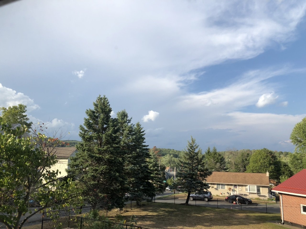
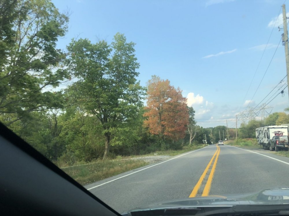
I think it's just the timing of the dry weather kick starting the process in some of the earlier turning trees, which has now lasted into the late summer pretty close to when things traditionally start turning. Like I said before, the majority of trees are still green.. but some areas you can see the scattered colors. I snagged a pic of this on the back road a few miles away.
-
Same here haha, just a light shower this afternoon. The local storms did the ole Tamaqua Split™ and left me with yet another day of misses. Most of the action seemed to drop through western PA. Hope you have a speedy recovery from your surgery.
-
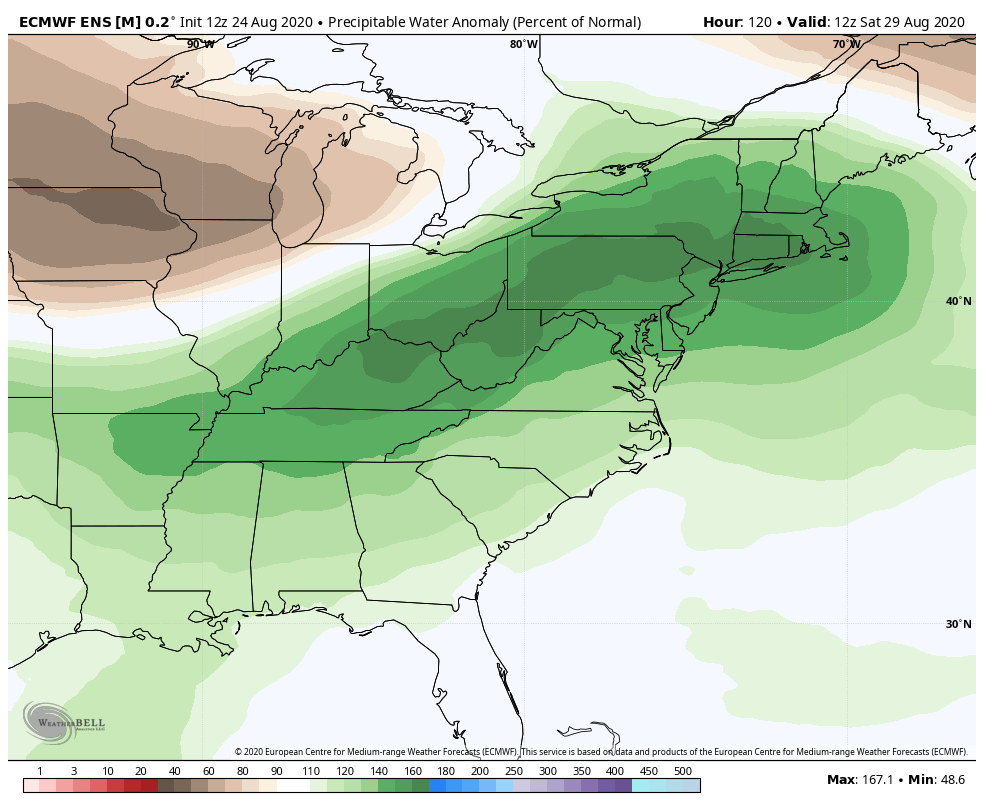
We wouldn't necessarily need the center of the remnant low to move through PA to see an enhanced rain potential given the approaching shortwave and trough, nor would we need a full phase or anything like that. Timing of features is fairly important as usual. If the trough progresses faster, that could cut off Laura's moisture from coming up here. Otherwise, aside from any possible direct impacts from the remnants, just drawing up the moisture laden airmass that accompanies a tropical system via southern and SW flow (from a probable landfall in the western/central Gulf coast in this case) charges up the PWAT's and you can have a heavy rain threat just from that from thunderstorm development in that airmass. A look at EC ensemble guidance this afternoon indicated pretty high PWAT's (generally 1.5-1.75") early in the weekend, which is around the time we would see anything. Here's the EC ensemble map of PWAT percent anomalies, most of PA about 160% of normal in this timeframe. That tropical airmass would also accompanied by yet another above normal regime temp wise ahead of that trough late week into the weekend. So I can already see where we could have thunderstorms develop with torrential downpours without the actual tropical system directly impacting PA. If these features time well, it could draw the remnants up and the approaching front could enhance an actual slug of organized precip.. which would be more beneficial in terms of regionwide relief from developing drought conditions. Much will probably change around this week. Laura definitely has a good shot at being a major hurricane and the main focus is where on the Gulf coast that is going to be. Most guidance has centered in that region of the TX/LA border. The 12z Euro ensemble mean was notably more west, focusing near the Galveston/Houston region.

-
Pretty much a dry day here today for the most part unless some of the remaining storms in western PA find their way here (doubtful). I'd say a rough guesstimate was about a half inch of rain yesterday, so hopefully can score some more tomorrow. One other observation lately around here has been the "fall" foliage. Obviously, the drought conditions have been a pretty big catalyst but there's a lot of trees with leaves turning colors. And some are turning to reds and oranges as well. Most of the tree foliage is still green of course, but it's noticeable. I've seen mid-late September foliage less further along than what we have currently... and it isn't even September yet.
-
The absolute shut out in precip the last couple weeks has come to a merciful end this afternoon with a couple moderate showers already and some heavier storms that look like they're about to impact here.
-
Regarding the tropical action, it seems like modeling is suggesting that TS Laura eventually gets picked up in a wide arc and could introduce a period of wet weather or perhaps even a more full fledged rain event. The tracks are all over the place though, GFS takes it in near the TX/LA border and arcs up the Mississippi Valley and around though PA. Euro landfalls further east in southern LA and lifts and arcs harder taking most precip under PA and Canadian is further east yet on landfall but gets precip into southern PA on the arc. This is merely observation on modeling and definitely not a high confidence thing. All modeling doesn't do much with Marco, which is actually the front running tropical system. Even the tropical models darn near fizzle the thing before it even makes landfall. I'm not particularly impressed with it at the moment, it's had some decent convection bursts but it looks like its starting to get elongated from shear. Personally don't think this comes in as a hurricane but in the Gulf things can turn in a hurry if a window of more favorable conditions presents itself. But it's forecast into a more hostile environment as it nears the coast. It doesn't look like we get too much moisture drawn up prior to the early week frontal passage, which looks like it will shut off that possibility. Laura has more of a chance to eventually have an influence. It has to get through Cuba first though... And its taking a lousy track that's going to stunt it's development probably for at least another 24hrs. It seems more well developed overall with less shearing influences and a more robust looking circulation. If it can hang on getting into the Gulf, this one will likely be a more formidable Gulf coast threat.
-
I swear I saw this exact map about this time last year lol. Yup.. we got the worst of winter alright.
-
It looks like the Atlantic Basin has a good chance lighting back up the next couple weeks. We are approaching the traditional peak of tropical season (approx Sept 10) for one, and we could be eventually swinging the MJO into phases that correspond with enhanced Atlantic Basin activity, which is the 1-3 realm, but esp 2 and 3.
-
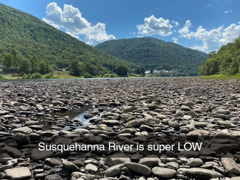
The drought monitor only goes back to 2000 I believe. This drought is definitely getting pretty severe in the short term sense when it comes to vegetation and stream levels, but we're not in a long term one yet that really gets into stuff like groundwater/reservoir issues yet. A reversal of the dry pattern for a few weeks (or a tropical system strike over the whole area) would probably shore up a lot of the issues. If this general pattern remains into the fall and early winter than we could be dealing with a more long term drought. Most of the main river/stream gauges have top 5 low water records to go with their top crests. There's a couple gauges where their current level would be about 4th-5th on the top 5 but most of them aren't that low yet for a top (or I guess bottom) 5. The 1960s decade seems to have a lot of low water records over several waterways. It seems like that was a decade that had a good bit of drought.
-
I was sent this pic of the West Branch just outside of Renovo over in western Clinton the other day. I guess that's what a -0.42' stage looks like lol.
-
Haha yea I'm just trying to get some water on the lawn in a couple places at time. I have a pretty big yard and I'm trying not to rack up the water bill too much haha. It was pretty well established so I'm hoping it's dormant and not completely roasted. Guess I'll find out.
-
Yea I definitely don't doubt there's more localized parts of the area that have been a lot worse off, and the center of the widespread drought conditions have been persisting right in the middle of the state. I knew you were down there west of Cashtown, there's just not a lot of official climate sites. I take your word for it, I mean I'm in the same boat haha but I dunno if I got a double digit deficit. If I were to make an educated guess based off of KAOO"s climate numbers which is 20 miles south of here, I'd say we're probably 6-8" off May/June/July. I need to get a weather station rigged up at my place so I can start keeping track of this stuff more accurately here. I was actually surprised to see MDT wasn't that far off average wise, although it looked like they were about 4-5" off until the first week of August with the hurricane and thunderstorms.