MAG5035
-
Posts
5,882 -
Joined
-
Last visited
Content Type
Profiles
Blogs
Forums
American Weather
Media Demo
Store
Gallery
Everything posted by MAG5035
-
Central PA 2020 Fall - The Hope begins
MAG5035 replied to paweather's topic in Upstate New York/Pennsylvania
Light frost here this morning and it got down to 34-35ish. If i'm seeing a bit of it in town I'm sure the usual spots outside of town probably had a pretty heavy frost or even a freeze. Several meso stations below freezing in the immediate area. Station in Philpsburg reporting a 27ºF and a couple on the outskirts of State College and near Port Matilda 30-31ºF. -
Central PA 2020 Fall - The Hope begins
MAG5035 replied to paweather's topic in Upstate New York/Pennsylvania
Fortunately the only thing I really got going outside right now is the two Knockout rose plants i planted in the late summer.. which are supposed to be fairly hardy to chilly nights like that. That mid May hard freeze and snow we had I don't know how that didn't take out some of the stuff that was growing then like the daffodils and the fully bloomed Magnolia tree. -
Central PA 2020 Fall - The Hope begins
MAG5035 replied to paweather's topic in Upstate New York/Pennsylvania
Wow lows in the mid 30s here the next 4 nights in a row. Sometimes we don't get a run like until most of the way through October. -
Central PA 2020 Fall - The Hope begins
MAG5035 replied to paweather's topic in Upstate New York/Pennsylvania
Smoke's maybe a tad thinner tonight. You can see some of the brighter stars tonight where last night about the only thing you could see was Mars, which is currently one of the brightest objects in the night sky (closest approach to Earth Oct 6th). Still can't really see much though, which is a bummer for star gazers b/c you couldn't ask for better viewing conditions right now between the clear/dry conditions (sans the smoke layer) and an almost new moon. -
Central PA 2020 Fall - The Hope begins
MAG5035 replied to paweather's topic in Upstate New York/Pennsylvania
That's a good question. My best take on that would be it's kind of a yes and no type thing. Yes the smoke particles limit the sun's radiation and that of course has an affect on surface temperatures, which we're seeing the effects of today. I don't know if i've ever seen wildfire smoke so widespread over the US. Part of it is a product of the pattern, most of the US is in a stagnant regime with broad 500mb ridging across the CONUS. Thus the smoke is just rounding the broad high pressure and not getting cleared out by any systems. The setup is also stuffing Hurricane Sally and making that a likely major flooding situation in that part of the Southeast when it finally makes landfall. Where it is not similar is duration/scope as well as makeup of the ash. I would imagine one is thinking of the long term global cool down as a result of a really major volcanic eruption scenario. When a big time volcanic eruption occurs, that will drive the volcanic ash all the way into the stratosphere. The wildfire smoke is riding the jet stream at about the height of a cirrus deck in our parts. High up but still in the troposphere. Weather will eventually clear the wildfire smoke particles (or volcanic particles) out of the troposphere. Dispersing volcanic sulphates takes a much longer time in the stratosphere. Also, being that volcanic ash is actually pulverized rock/minerals/glass.. it is likely a good bit more efficient at reflecting the sun than wood ash is. -
Central PA 2020 Fall - The Hope begins
MAG5035 replied to paweather's topic in Upstate New York/Pennsylvania
KAOO was down to 40ºF last night, and a look at the local mesowest stations showed about the same (39-42ºF). One of the Penn State Ag stations in the fields SW of State College was down to 36ºF as was one near Port Matilda. Those valley areas, especially the Barrens region which is near the Penn State agricultural fields are very good radiational cooling areas so it's likely there was some scattered frost this morning even in this general area. -
Central PA 2020 Fall - The Hope begins
MAG5035 replied to paweather's topic in Upstate New York/Pennsylvania
This was my post on this last night, as CTP had a good explanation in their discussion. -
Central PA 2020 Fall - The Hope begins
MAG5035 replied to paweather's topic in Upstate New York/Pennsylvania
Pretty interesting and informative disco from CTP tonight...A little reminder of Meteo 436 (Atmospheric Radiation) a long time ago. Adjusting temps down some tomorrow due to the smoke remaining in the upper levels. Frost advisory up for McKean County (Bradford area) tonight. -
Central PA 2020 Fall - The Hope begins
MAG5035 replied to paweather's topic in Upstate New York/Pennsylvania
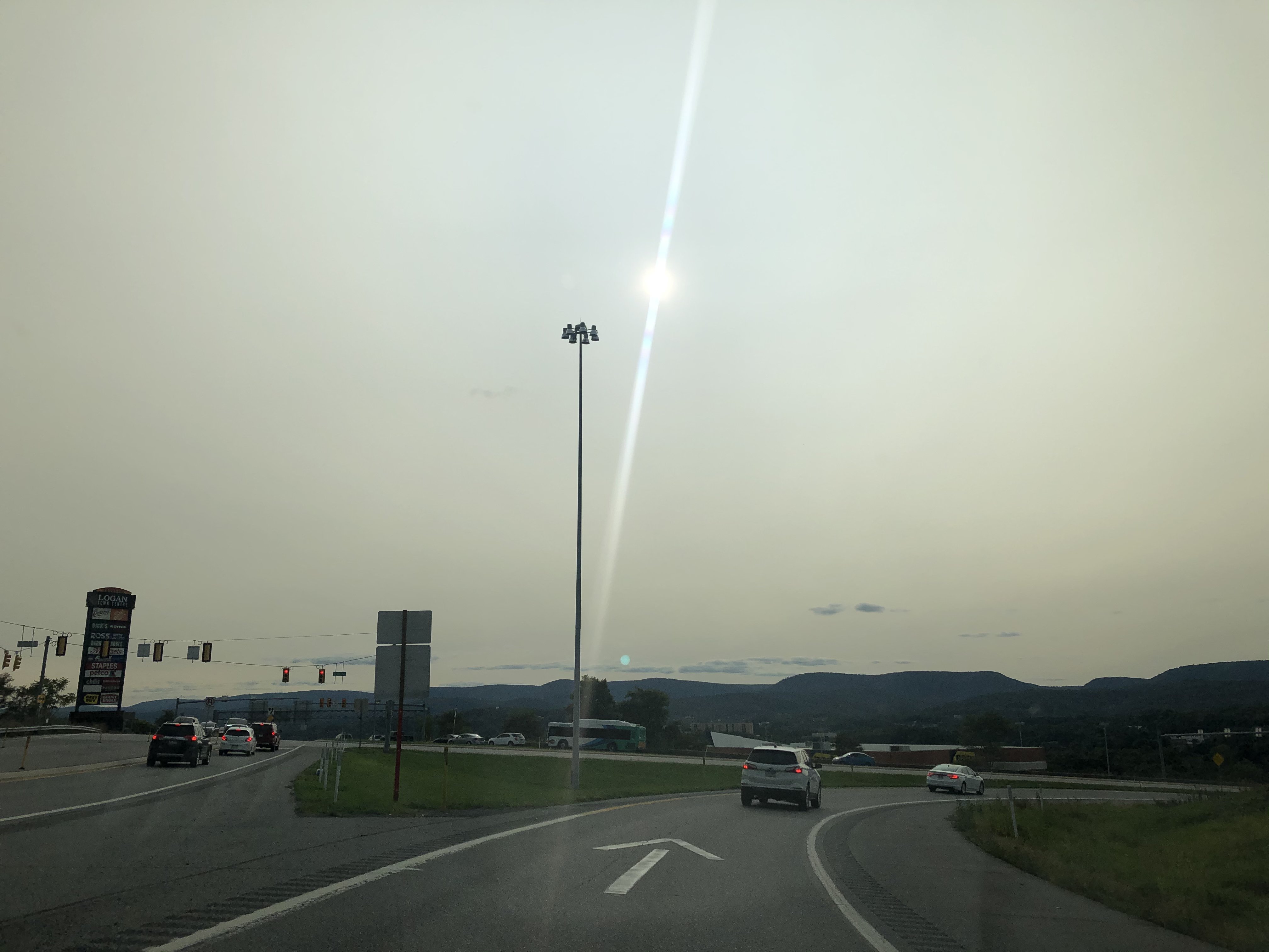
Pretty impressed how much the sun was filtered through the smoke in the higher levels today. Took this coming back into town about 20 min ago.
-
Central PA 2020 Fall - The Hope begins
MAG5035 replied to paweather's topic in Upstate New York/Pennsylvania
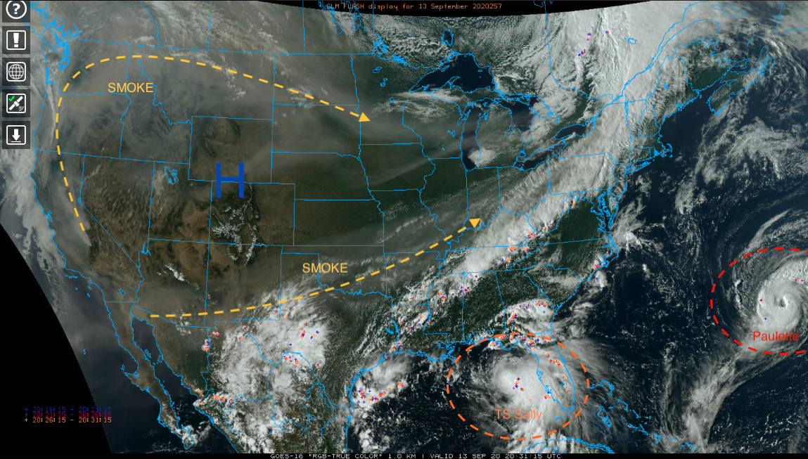
I don't think we've made it to 70 here today under the clouds and had a couple decent showers late morning/early afternoon. Pretty much been cloudy here since Friday. You can see on satellite how the frontal system working through central PA this afternoon has drawn some of the western wildfire smoke up into it at the higher levels from the SW and also from the NW some. Also you can see the two big ticket tropical items Paulette and Sally. Will have to see how much Sally eventually gets drawn up north before being shoved out ahead of another frontal push late week. Euro ensembles show some reasonable precip chances southern half of the state but right now it seems the general model consensus is the majority of eventual remnants stay south of PA. So we'll see how that goes. Right now Sally's being forced under the current frontal boundary to take its forecasted WNW toward the LA coast. That's also contributing to the westerly shear on it attm as well. Hopefully it doesn't get too wound up, because that is a bad angle to take towards New Orleans. Next weekend looks dare I say, kind of chilly behind the system that eventually kicks Sally away. Could be a decent chance of some frost in northern PA as well as the usual cooler suspects in the Laurels and central counties. The first couple days this week after the passage of today's system looks pretty nice as well, with Tuesday morning the chilliest and a more limited frost chance (Bradford/Allegheny National forest region).
-
Central PA 2020 Fall - The Hope begins
MAG5035 replied to paweather's topic in Upstate New York/Pennsylvania
Goodness I hope everyone has a quick/full recovery from all the injuries. We're gonna have to put out an injury report when we're full swing in the wintertime at this rate lol. -
Central PA 2020 Fall - The Hope begins
MAG5035 replied to paweather's topic in Upstate New York/Pennsylvania
Today was low key one of the more muggy days of a summer that's had wall to wall hot weather but not necessarily much of the hot/humid combo. That region seems to be on the kind of insane run of way above average precip that the LSV saw the last two summers (especially 2018). -
Central PA 2020 Fall - The Hope begins
MAG5035 replied to paweather's topic in Upstate New York/Pennsylvania
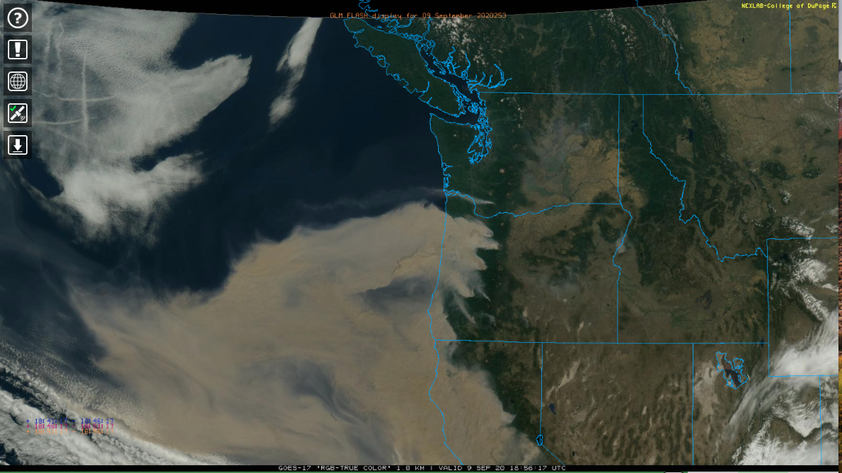
Also, since it's fairly boring around here today.. here's another shot of how widespread the wildfire smoke is in the Pac NW and California. Also jet contrails in the clouds on the NW corner of that shot over the Pacific.
-
Central PA 2020 Fall - The Hope begins
MAG5035 replied to paweather's topic in Upstate New York/Pennsylvania
We're less than two weeks from the fall equinox, it's getting harder and harder for even the H-burg desert to get near that 90 degree mark without having a pretty anomalous airmass around. Looks really nice early next week after the passage of a system Sunday that might finally provide some regional rain chances. Also a chance of some thunderstorms mainly in the LSV tomorrow as well. The 12z Euro is actually quite robust on QPF especially in York/Lancaster counties. -
Central PA 2020 Fall - The Hope begins
MAG5035 replied to paweather's topic in Upstate New York/Pennsylvania
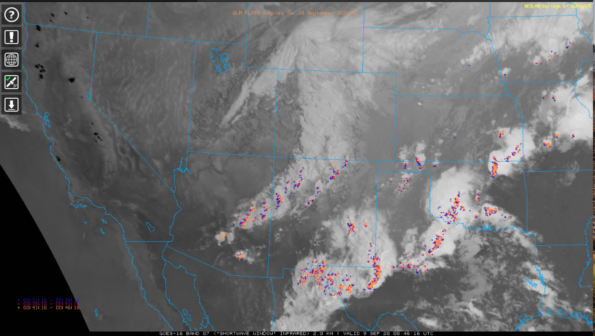
Wow what a loop, if anyone sees this soon you can see the very robust storm in the Rockies wrapping in some of the wildfire smoke from California and Oregon. Insane how big those fires are and how much smoke is being generated. https://weather.cod.edu/satrad/?parms=regional-southwest-truecolor-96-1-100-1&checked=map-glm_flash&colorbar=undefined https://weather.cod.edu/satrad/?parms=subregional-Oregon-truecolor-96-1-50-1&checked=map-glm_flash&colorbar=undefined I'll add in this shortwave IR snapshot. Every one of those black spots in California is a wildfire area, and there's several more further up in Oregon too.
-
Central PA 2020 Fall - The Hope begins
MAG5035 replied to paweather's topic in Upstate New York/Pennsylvania
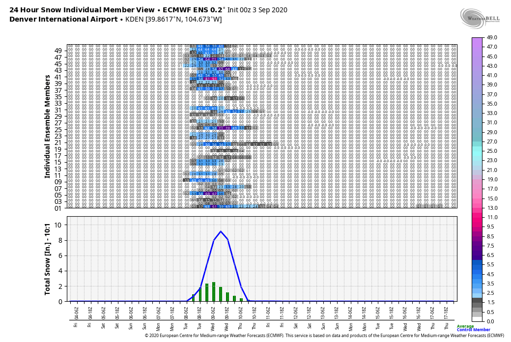
Yea I'm not sure what would be crazier on it's own there, the late 100+ heat or seeing the snow. Obviously the combination of the two things within a day is insane and historic, especially in terms of temp differentials and departures. But honestly the heat wave part of this is likely the more extreme thing. It's relatively normal for the Rockies to start seeing higher elevation snows in September and Denver in fact averages 1.3" in September. It would appear that the only snow record Denver would break looking at what's being forecast there is possibly the heaviest first snowfall of the season. The earliest is 4.2" Sept 3, 1961. https://denver.cbslocal.com/2020/09/04/weather-whiplash-colorado-record-heat-cold-snow/ This article also mentioned the last measurable September snow at Denver occurred September 24th, 2000. So this hasn't happened at all in September in the last two decades. -
Central PA 2020 Fall - The Hope begins
MAG5035 replied to paweather's topic in Upstate New York/Pennsylvania
It'd be nice if some of that thunderstorm activity found it's way down here later on. But in the meantime the cloudcover all day from it has pretty much shut down what was looking like yet another high 80s day. -
Central PA 2020 Fall - The Hope begins
MAG5035 replied to paweather's topic in Upstate New York/Pennsylvania
Lol i could just imagine the “ground is gonna be too warm for accumulation” discussion. -
Central PA 2020 Fall - The Hope begins
MAG5035 replied to paweather's topic in Upstate New York/Pennsylvania
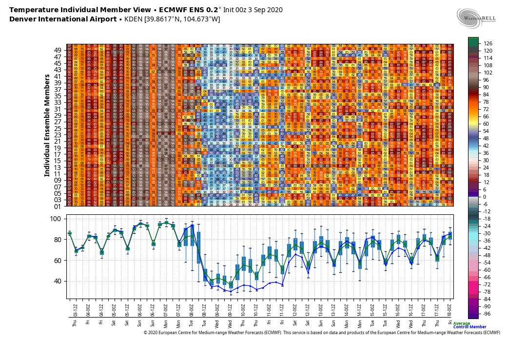
Yup sure do, Denver may have their first snow of the season with that trough dumping into the Rockies. The Euro has been showing that as well. How's this for insane...look at the Euro ensemble output for KDEN. Literally supposed to be 90-100 for a high for a few days right up to the day before it maybe snowing there.

-
Central PA 2020 Fall - The Hope begins
MAG5035 replied to paweather's topic in Upstate New York/Pennsylvania
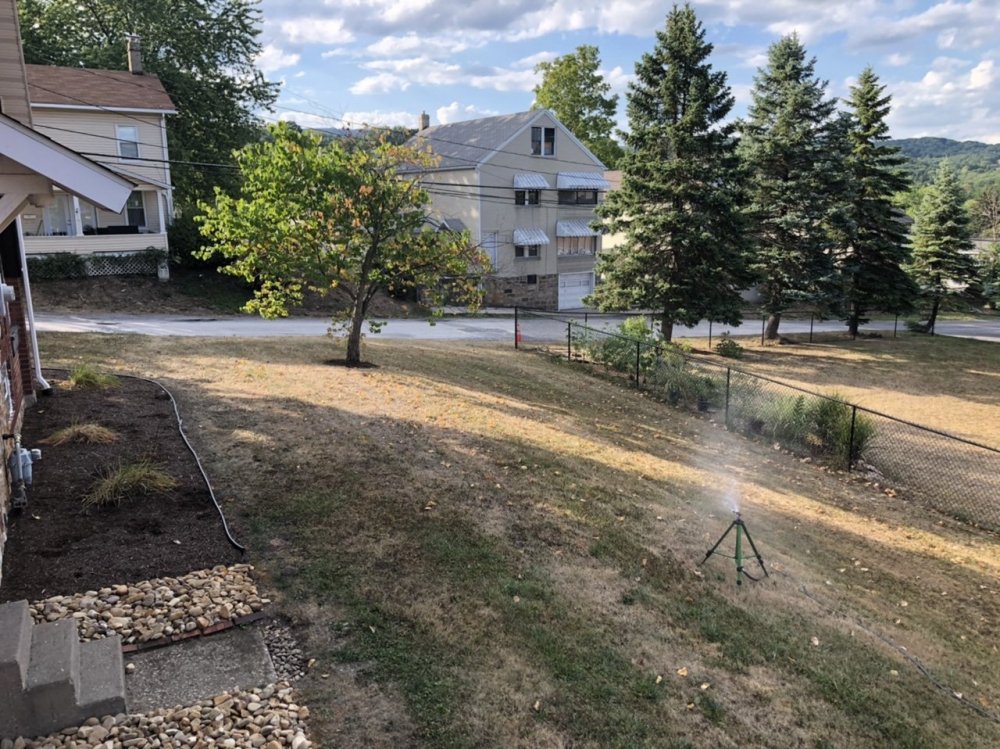
I’d say the yard made a heck of a turnaround in the last two weeks. August 18th Today: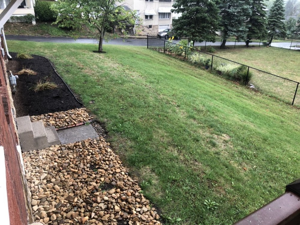
-
Central PA 2020 Fall - The Hope begins
MAG5035 replied to paweather's topic in Upstate New York/Pennsylvania
You must be forgetting our first three months of the year featured cutter after cutter after cutter...after cutter. That's okay I don't blame you lol. We were wet the past winter into the early spring. We would likely have been in a more advanced stage of drought (longer term effects) had the last winter been a dry one to go with the mild. -
Full blown light to moderate drizzle currently. I think the Euro was better off when it was Dr. No (Dry), what a whiff on that in the short range.
-
JB out with a warm eastern winter and approx 75% of normal snowfall in the mid-atlantic region stretching up to PA southern tier on his first winter outlook today. Low expectations...I like it lol. So you can do with that info what you please. I will say the outlook is a little more on solid footing info-wise than "sheets of sleet".
-
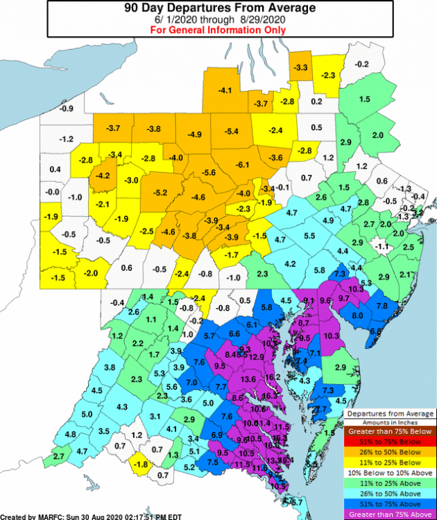
I never did get to throw a response about the Mid-Atlantic folks saying where's the heat since we've been cranking through pages at a mid-winter pace this summer. Yea it has been a very hot summer in central PA. For me personally, there has definitely been summers with more blistering heat waves... but this has been one of the most consistently hot summers I can really think of. Humidity hasn't really been excessive this year, we've only had a few times where heat headlines were needed anywhere in the region. I think the combination of lack of excessive humidities and the overall dry ground conditions have contributed to the amount of 90º+ degree days seen in especially the Harrisburg/LSV area but regionwide as a whole. I really haven't focused on the Mid-Atlantic much, but it seems like it has been way wetter down there overall. Look at the last 90 days down there compared to PA. I know Isaias is a chunk of that, but there is still a significant + departure in that region. I would venture a guess that part of why they are saying where's the heat is because DC and surrounding counties are running a whopping 8-12" above normal since June 1st. That and Harrisburg's summer 2020 would probably be business as usual for a DC summer.
-
Boy some of this short/near term guidance tonight is suggesting a good portion of this rain event tomorrow is a turnpike and south affair, at best.