MAG5035
-
Posts
5,882 -
Joined
-
Last visited
Content Type
Profiles
Blogs
Forums
American Weather
Media Demo
Store
Gallery
Everything posted by MAG5035
-
New CTP grids for tomorrow. Meso models have been showing better development of WAA snows ahead of the approaching primary clipper low tomorrow morning in the central and northern tier counties. Seems quite close to an advisory event being advertised on the 18z 3k NAM, RGEM, and esp 18z HRRR from CTP’s I-80 corridor north (perhaps down to KAOO on the 99 corridor). So wouldn’t be surprised to see some headlines up later this eve. It’s a pretty decent low as far as clippers go but this fades and hands off to secondary development off the coast, which leads to some questions of how much precip translates over into the Sus Valley, which seems to be a weak spot between the primary and secondary handoff in the progged alignment. Also an inverted trough element to this as well which could focus a more narrow band of snowfall somewhere in eastern PA later Friday (likely aligned NW-SE north and east of MDT). PSU game Saturday def looks cold, though I’m not really buying the SMU not being able to handle the cold angle. I think Penn State should handle its business but not because it’s too cold for SMU to handle. Noon kickoff will be “warmest” time of the day with UNV temps progged around the mid 20s, Winds are brisk but not insane (gusts to 25). Might be some lingering snow showers, especially in the morning. If this were a night game I could see temps being more of a factor since Sat night will likely go well into the teens. The one thing that could be an issue for fans is whatever happens tomorrow. 1-2” is in the grids now for State College. They get the high end of that or some kind of overachieving event that’s a bit more and that could make for some parking issues in the grass lots.
-
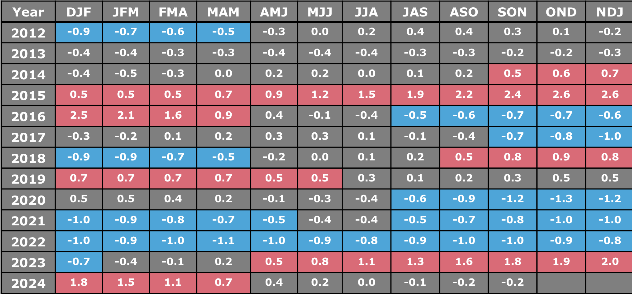
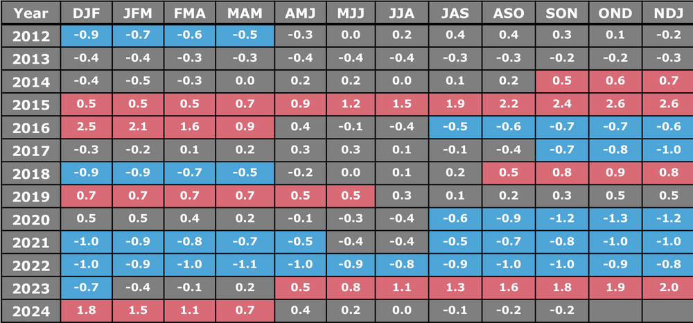
ENSO has yet to emerge into an actual La Niña, we are and have remained at ENSO neutral all year since the Nino faded last winter. I have my doubts we ever actually end up with an official one (which needs 5 consecutive 3 month average periods of < -0.5ºC in 3.4). With the way the week to week has been going with ENSO temps so far this month, I would expect the OND average to be another neutral once this month wraps up. What may happen in the next month or so is SST’s dip into perhaps weak Nina territory, but I wouldn’t see it as having any major influence. Models really busted on this from early in the year when most were projecting a full blown strong Nina. I think one of our issues with the pattern alignment stem from generally having a +NAO/AO. What we do have right now that has been missing the last I don’t know how many winters is a positive PNA that has seemed to have some staying power. That has kept a mean trough on this side of the country which has kept us cold more often than not but the +NAO/AO has kept stuff from really digging. Another issue is we’ve also been working a phase 5 MJO pretty much the whole month so far, which is not really an ideal phase to be in. The fact we’ve been so cold has been a bit of a minor miracle IMO. Without that western ridge, we likely would have been roasting. Following another cold shot coming this weekend, it does appear that the week between Christmas and New Year’s is likely to be an anomalously warm one as the EPO is slated to go positive and will likely overwhelm the CONUS with warmer air despite the continued ridging in the west (+PNA). With the MJO, Nina’s favor phases 4-6…so that’s where I feel the ENSO neutral conditions could be a good thing in the longer run as the MJO could actually be allowed to rotate into the more favorable phases at some magnitude and not stall in the bad ones. Models are already putting the MJO in Phase 7 by the end of the month. A 7-8-1 run would have a decent chance of delivering a better storm pattern for us as well. So I think we’re going to set up for a good period at some point when we get into next month, especially if we can keep the +PNA.
-
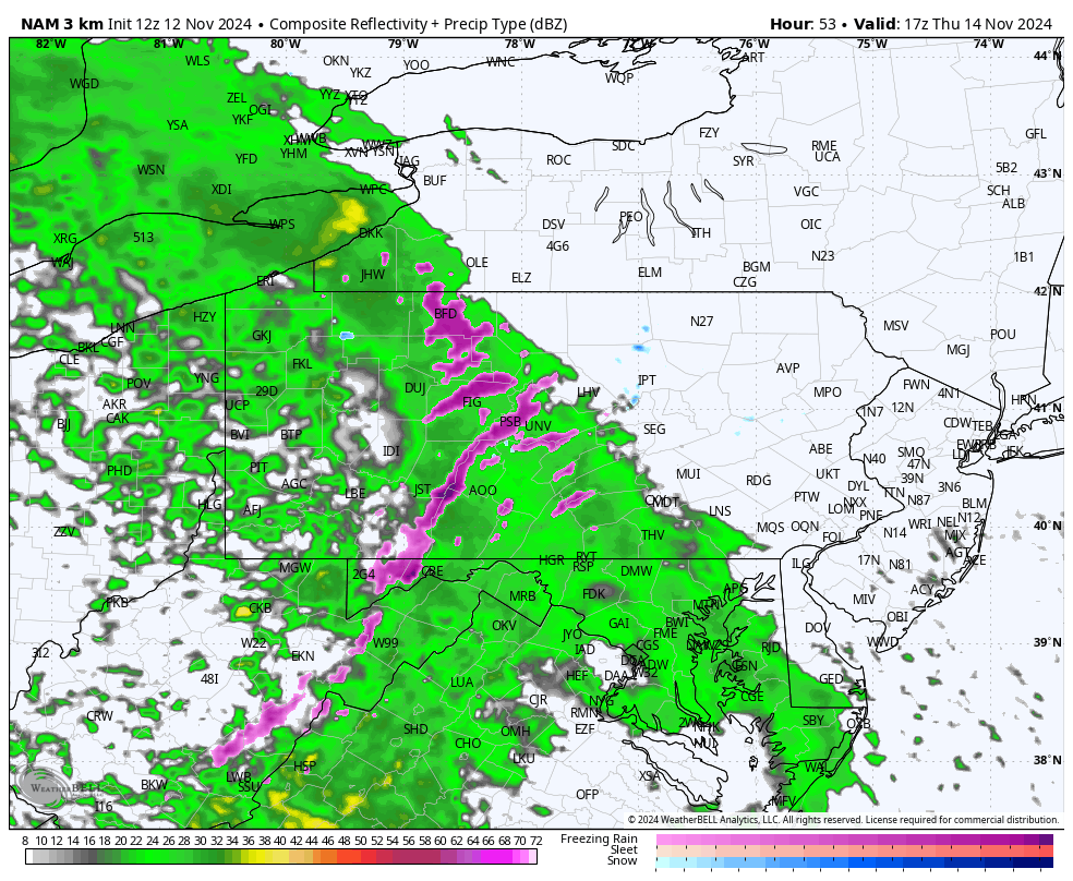
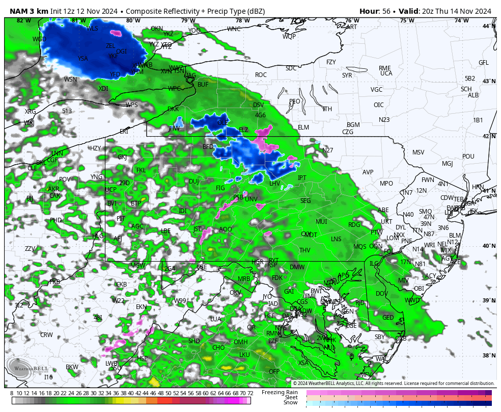
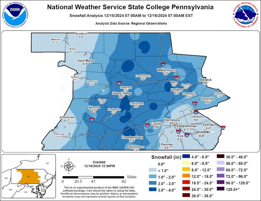
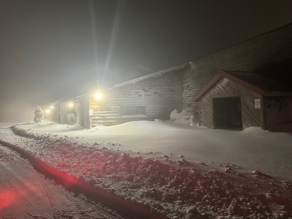
I just thought maybe it was a case of they only report 12/24hr snowfall at 7pm/am (0/12z). Original forum post this morning with the MDT climo report was issued at 220am where the “revised” one was issued 713am. At any rate here’s this, it seems most CTP stations saw something measurable yesterday. 2.4” was my final tally here, most of which is still on the ground currently as we’re socked in fog and it’s only 34ºF.
-
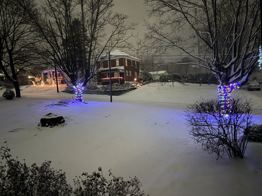
Working on 2” here with a nice steady snow falling and 30°F. First snow pic of the season
-
Been transitioning through pingers with snow mixing in now after the freezing rain start as the column cools. It was just enough to glaze the driveway and back street. 31/28ºF
-
Update, precip started here and it’s currently straight freezing rain.
-
31/26ºF here with the precip on the doorstep. It’ll be interesting to see if this overachieves in the snow department here today. Models have been progging the column temps to fall a couple degrees below freezing at 925 and 850 upon precip onset. I’m thinking there will be a period of snow for a bigger portion of the LSV than what is being broadcast for advisories. Whether that escalates into an actual advisory event in Harrisburg/York/Lancaster is debatable but it’s certainly possible. I’ve liked the HRRR’s more frozen vs rain (colder column after onset and during first part of the event) over the 3k NAM’s more widespread freezing/mixed precip during its wintry precip portion of the event. We’ll see how that goes today. I think primary freezing rain threat resides in the Laurel Ridges, however I will say given how cold it has been that rain and marginal temps at or a degree or two above freezing may freeze up some surfaces like non-paved driveways and other untreated cold surfaces. It was 12ºF for a low here Saturday morning and was down as far as 21ºF last night before clouds moved in a brought temps up overnight. Ground is frozen solid.
-
Temps have rocketed to 57ºF here today (58ºF at one point). Had a tad over an inch of rain fall yesterday (1.05”). Some models are coming back around to the rain to snow scenario over a bit larger of an area of C-PA later tomorrow. Best handling ones are likely gonna be the high res stuff like the 3k NAM. I think most of us could see some kind of changeover but this is likely to be yet another elevationally driven event in terms of accumulations. There’s a sharp temp drop progged behind the frontal passage but probably not sharp enough in lower elevations to get meaningful accums. The big story with this event is likely to be the much needed rainfall. SW PA and WV has seen some meaningful improvements on the drought monitor the last couple weeks and it appears that tomorrow’s system is going to really help the more significant drought conditions in eastern PA and the megalopolis (and surrounding) region as a whole.
-
Lol I actually have lived in Altoona for the last several years now. I haven’t really seen a reliable answer yet on which McDonald’s it was. I’m a two minute walk from one of them. The most likely one that is close to the bus station downtown is a couple miles away from here.
-
About 1.5” total fell here mainly last night and early this morning. I slept through it but there was thundersnow with the frontal passage around 2am last night. Very cold and blustery day today with a high wind gust measured on the station at 40mph. Temps only topped out at about 25ºF today post frontal passage. They did spike after the initial inch of snowfall last night all the way up to 39ºF after midnight prior to the FROPA at 2am. Anyways radar presentation this evening shows a more classic LES/upslope regime with more discrete bands aligned with the cyclonic NW flow. The band stretching through Clearfield County has a Huron connection and will likely be the best bet to deliver continued accumulating snowfall underneath it.
-
About an inch on the ground here already with roads caved. 29°F
-
I started meaning to mainly just comment on Thursday and got a bit carried away haha. I could always yell out the details condescendingly for 5.99/week lol. Grammatical and spelling errors are gonna cost extra though.
-
I think given the lack of a surface high to the north and much antecedent cold air available the best play for this potential Thanksgiving system is for a weaker/more suppressed wave. The 0z NAM was pretty close to delivering what the Euro has been advertising with a stronger wave that lifts the boundary just a little bit too much. Thus it gave probably about as good a solution as you could ask for in this setup for the central/northern counties. NAM solution kind of splits the difference between that and the 0z GFS and RGEM so far, which are weaker and more suppressed but still get some precip into PA. With either scenario temps are going to be very marginal and may still not be cold enough in the southern tier and Sus Valley even with the farther south/weaker scenario. Temps will be seasonably chilly after the frontal passage tomorrow night thru Thanksgiving but late November seasonably chilly is borderline with delivering snow. We need anomalously chilly.. which is only coming behind the system. Beyond that lies one of the colder starts to December we’ve seen in awhile, with solidly below average temps looking quite likely. Deep cyclonic flow centered south of Hudson Bay is going to light up the Lakes all the way through the holiday weekend. Flow initially looks okay to get our favored Laurels areas (Friday night) but then mostly appears to favor WNW/westerly downwind lakes locations just north of C-PA for most of the weekend. Some semblance of a weak clipper type wave showing around Sunday-ish on all models, which may be the best shot at a light snowfall in the interim. 0z GFS/Canadian too far south with it. The Euro.. while still plenty cold here seems to be running a tighter boundary and had a better solution at 12z (although major downsloping off the Alleghenies). That run progged -12ºC at 850 and -20ºC at 700mb. Obviously would be a high ratio event with numbers like that. Pretty far out of course, but thats the quick rundown on that feature. Wouldn’t take much to turn that into a nice widespread light event given that it’s going to be plenty cold at the surface and especially aloft. At any rate, ski season should be able to get an early start this year as this colder pattern looks to have at least some staying power. Only issue of course is the lack of bigger storms showing on the pattern, as it looks to be a mainly northern stream dominant regime and fairly progressive. But we’ll see how that evolves in time.
-
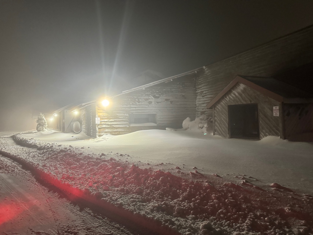
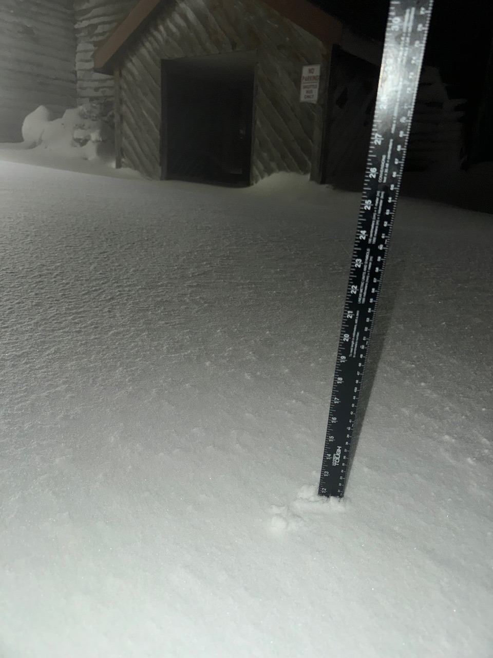
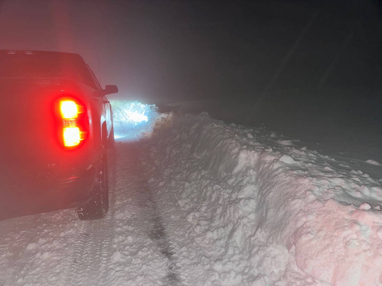
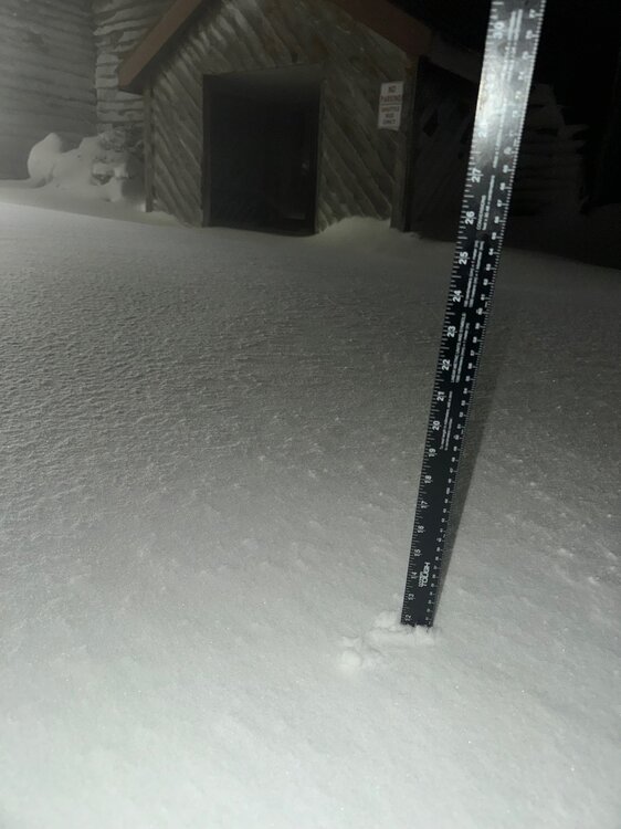
The 30 minute trip up to the 3100’ summit at Blue Knob certainly did not disappoint. Got an 11 and a 12” measurement. Drifting had been pretty significant up there during the height of the event.

-
1.2” was the best accum measured at the house today. Surface temps were just a couple degrees too warm in the early afternoon when the best snow rates were falling before transition to rain. Been mostly rain/white rain for a bit now with up to 0.85” for the day in precip. Currently about 36ºF. I spent the morning on Tussey Mountain in NW Huntingdon Co for the last day of archery and by mid afternoon there was likely 4-6”+ above 1800’ on that ridge, esp towards State College. This is still ongoing in the Laurel’s, might have to make the 30 minute drive to the top of Blue Knob to see the situation up there. I bet there’s monster totals at that elevation.
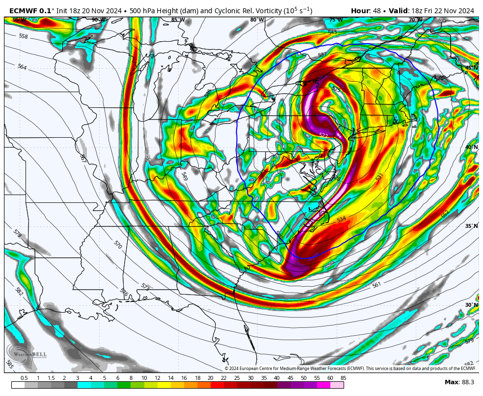
-
Temp is down to 40ºF here with 0.43” of rainfall and a high gust as measured by my weather station at 33.3mph. Things definitely are still are track for this Thurs night/Friday event. Timing seems to be Friday morning to later Friday afternoon for the non upslope enhanced precipitation associated with the low itself. All things considered computer models have been very consistent with each other the last few days with the evolution of this system. What I’ve noticed with the latest couple runs is the surface low is now being progged to backtrack all the way around the ring to make it into eastern PA, with the very deep 500mb low basically centered on PA for a time now. Basically this lends more support to potentially seeing a period of snow even into most/all of the Sus Valley now.. with elevation driving the level of success of any accums. The main part of this event as mentioned likely centers on Fri morning-afternoon as modelling has been progging the main wave of precip as a sort of spiral arm off the backtracking low pressure. It’s going to be interesting to see this unfold, as it’s a bit of a unique setup. The backtracking nature of this system lends to an actual example of a fujiwhara effect. Looking beyond, yes Thanksgiving/Thanksgiving Weekend has my attention. A storm had been showing up on op models in this timeframe in various forms more often than not on despite the range the last couple days even before today. So storm signal was already there, but they really upped the ante today. Ensembles are starting to see it a bit too. System progged for mid-week looks to be a key to maybe setting the boundary as well so we’ll see where things head the next few days with this. There should be plenty of cold on the playing field with the right setup.
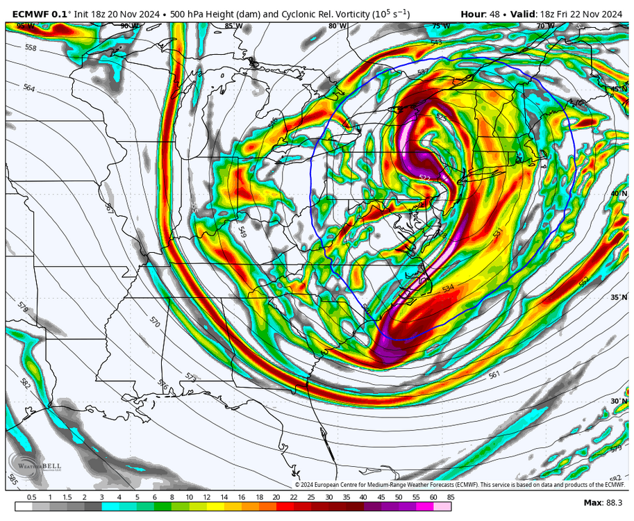
-
The key to this making for any kind of semi interesting wintry action off of the aforementioned mountains is how far the coastal low retrogrades back toward C-PA. There’s a finite window of opportunity with this. Low is progged to be stacked, so there will be a cold core centered on the low that could deliver barely a cold enough low level column for a period of snow in lower elevations. The 500mb trough/low itself is highly anomalous for this time of year. Given how marginal temps will be, the closer this backtracks toward C-PA the better the chance of that. Once the closed off low and associated cold core starts tracking away, we lose the marginally cold column temps at the lower levels. Really initial thoughts for C-PA… I don’t really expect much in the Sus Valley, but it could certainly mix for a time or even be a period of snow with any minor accums relegated to the ridges down there. Surface temps would figure to be the biggest issue of all the C-PA regions. Models have been progging a good bit of backlash precip, and that is the other part of the equation. Westerly component would make downsloping an issue off of the Laurels to some degree, especially down in the LSV. Trying to size up this threat for the central counties.. as it could be quite variable. Anyone in the AOO/UNV/IPT corridor probably sees an all snow period Thurs night into Friday, but likely a highly elevational component as far as accums. I could see the Seven Mountains region and the first few major ridge lines past the Allegheny front seeing advisory amounts above a certain elevation (likely >1800ft). The valleys probably see more like a coating to an inch or so. Definitely looking at an advisory type event in the Laurels/western Mountains and I expect headlines in Cambria/Somerset/possibly Clearfield, Elk, etc eventually. The highest Somerset elevations has a shot of seeing warning totals. Given progged track of the coastal this could be a snow bomb for the higher Poconos elevations as well.
-
Certainly the prospects for the first accumulating snowfall of the season look quite high for the higher elevations of western PA as well as the Poconos given progged evolution of that retrograding low. There’s some indications this could be a bit more prolific than a typical couple of inches at elevation type of first upslope snow event. There’s two aspects of this event.. first the initial passage of a very vigorous shortwave that will be accompanied with hopefully a period of rain and then a strong frontal passage that could turn the mountains to some snow at the end Wed night into Thur. The second aspect is the carving out of a highly anomalous 500mb trough and closed low Fri/Sat which will set up a longer duration period upslope/LES as well as potentially some precip associated with the low itself as it meanders/retrogrades just north of C-PA. Main model difference at the moment appears to be thermals. Euro is warmer on the column overall by a few degrees than the GFS, which could be the difference between the Laurels seeing a few inches that is more elevation dependent within that zone (above 2k for example) and an upslope event that delivers a much bigger event to most/all of the Laurels as well as some elevation dependent accumulating snows that expand into the central counties with first flakes that are seen in most of C-PA. More certain is further south in the elevations of WVA, which almost double up the elevations of most of the Laurels. That is going to be a big upslope snow event down there. It’ll be interesting to see what happens, this type of setup has been somewhat rare as of late. The Laurel’s region of PA has had some of the highest % departure from average snowfall of anywhere else in PA the last several winters and a big part of that is from a lack of these NW flow/upslope setups.
-
To add to this, the EPO and WPO are both slated for a massive reversal to highly negative this week on the major ensembles… and staying negative out through the rest of their runs. That’s going with a generally negative NAO throughout as well. Only nitpick I really have is PNA staying mostly negative (GEFS eventually tries to get it positive).. which may weigh the cold air on the playing field in western Canada toward the western US at least initially. Either way, there is definitely a window of opportunity presenting itself from the last week of November into the opening week of December with what appears to be a decidedly more active pattern. I’m a bit late to the winter commentary in terms of thoughts on how things are going to go overall. Obviously the very highly negative PDO looms large with the gloomier aspects of our snow prospects. But what is not looming large is the ENSO. Forecasts in the spring for a moderate to strong Nina by this time of the year were much too robust and as of last week’s weekly ENSO report we still remain ENSO neutral (3.4 is at -0.3ºC). A stronger, established Nina coupled with the very -PDO state would have implied MJO spending a lot of time in the bad phases during the business end of winter. A neutral ENSO (or perhaps one that eventually transitions to a weak Nina) could present more favorability from the MJO realm.. at least at times. NAO blocking could be a wildcard too. 20-21 actually had the strong -PDO as well as a moderate Nina but that ended up being a decent winter here with the big hitters in mid December and beginning of Feb. There was a good bit of help from the NAO that winter. So I’ll acknowledge we likely have more of an uphill battle for getting at least an average winter, but I’m going remain cautiously optimistic with low expectations. I’ll go out on a limb to say I think we have more opportunities overall than last winter setup wise… but whether we capitalize on them is another story. Scoring something right out of the gate next month would certainly improve the prospects of respectable numbers for the winter.
-
We might not have to look too far in the future for wintry precip in C-PA by the way. While likely to be relegated to the north-central and Laurels, the overrunning precip slated for arriving Thurs morning is being portrayed as freezing rain (Allegheny Front and some of the ridge lines in the ridge and valley) and perhaps a period of snow (primarily higher north central) on some models. This was mentioned in the AFD this morning.The NAM and GFS (until todays 12z) has been hinting at this the last couple runs. The Euros thermals are debatable even though it shows mostly rain. The setup is there in terms of having some cold air damming with high pressure north of Maine and the approaching weakening surface low. How far temps drop Wed night will figure into any ZR. Otherwise, how much column temps cool at the onset of the overrunning will dictate any snow potential. Again, this potential is primarily in the north-central.. but still a reminder we’re not very far off from more wintry things.
-
Up to 0.48” on the event so far here. It’s been awhile since we’ve had a 44ºF synoptic rainfall. While we’re going to need a couple decent rain events to start to address the longer term hydro issues in areas that have been under more significant drought conditions (mainly in the SW and SE parts of the state)… this rain should put an end to what had been a very high wildfire threat not often seen around here. The combo of the near record to record dry October and the remaining dead leaves falling/dying or dead forest undergrowth really made a unique setup for having several bigger wildfires which were likely mainly caused by careless burning this past week with the windy/dry weather. I’m eyeing some more wholesale changes to the weather pattern in the 11/20-25 range as we get towards Thanksgiving week. Way out there yet but modelling has been showing variations of a more significant weather system/amplifcation in that timeframe perhaps ushering in the first stretch of more wintry temperatures and perhaps first flakes. The pattern does at least look more active in the meantime as well, with one or two rain chances showing.
-
KAOO appears to have already eclipsed its daily record of 78ºF set back in 1950 (topped 79ºF a bit ago). UNV’s daily record also set in 1950 is 81ºF and it’s “only” been about as high as 77ºF so far today so that one may still be safe. Here at the house it’s been as high as 79ºF and currently at 78ºF. Quite breezy today as well.
-
The potential of that is on the table. Certainly the opening 10+ days of the month look very warm…probably to the point where it’ll be hard to reverse what will likely be sizeable + departures even if we have a normal or colder than normal regime set up later on in November. We need a major shakeup in things to get the ball rolling toward some kind of a different pattern. We’ve had frontal passages and such but not any kind of major systems so far this fall that could be a catalyst to driving a more meaningful pattern change.. hence the persistent lack of rainfall here and the relatively stagnant pattern. Not really seeing a change in that status quo on modelling currently. MJO poised to make an 8-1-2 run, which figures to keep the tropics alive for potential late season activity in close near the US from that realm. Even with that, the mid latitude pattern doesn’t really look too conducive to yanking something like that up to juice up some kind of major system either. Eventually that change will come, but how long it takes will determine whether a really warm front part of November turns into the warmest one overall.
-
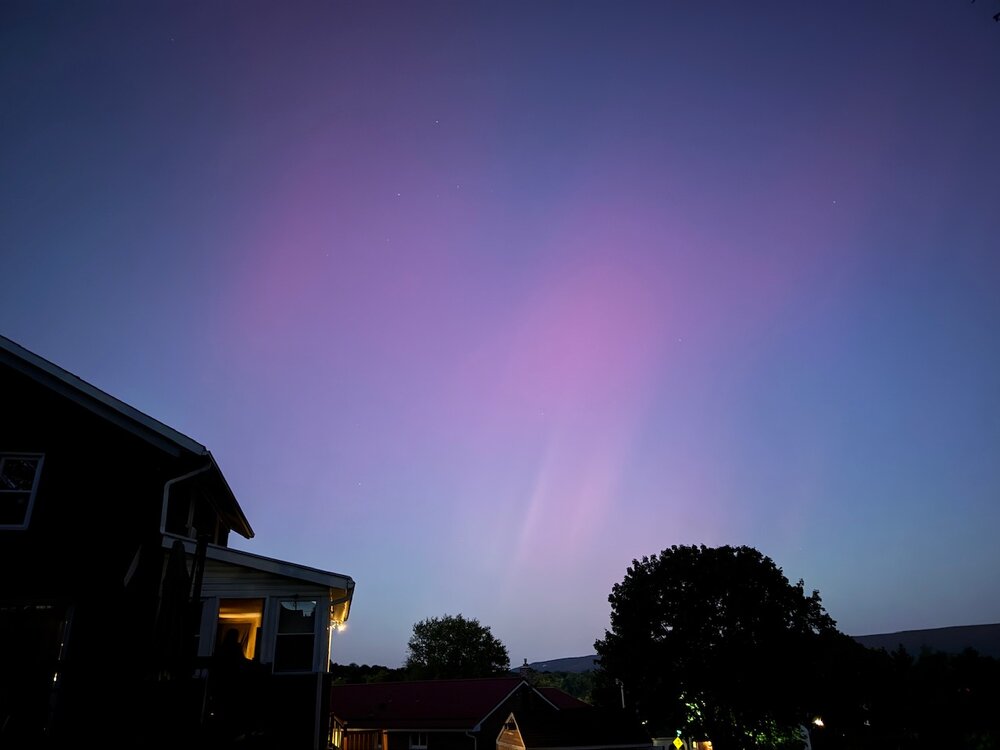
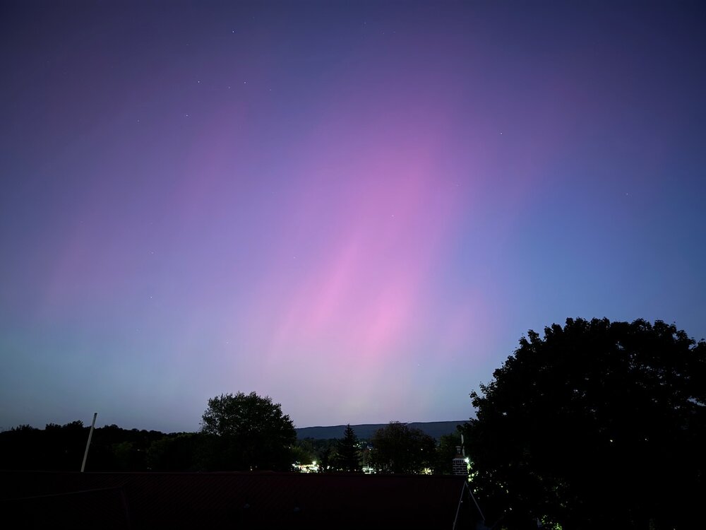
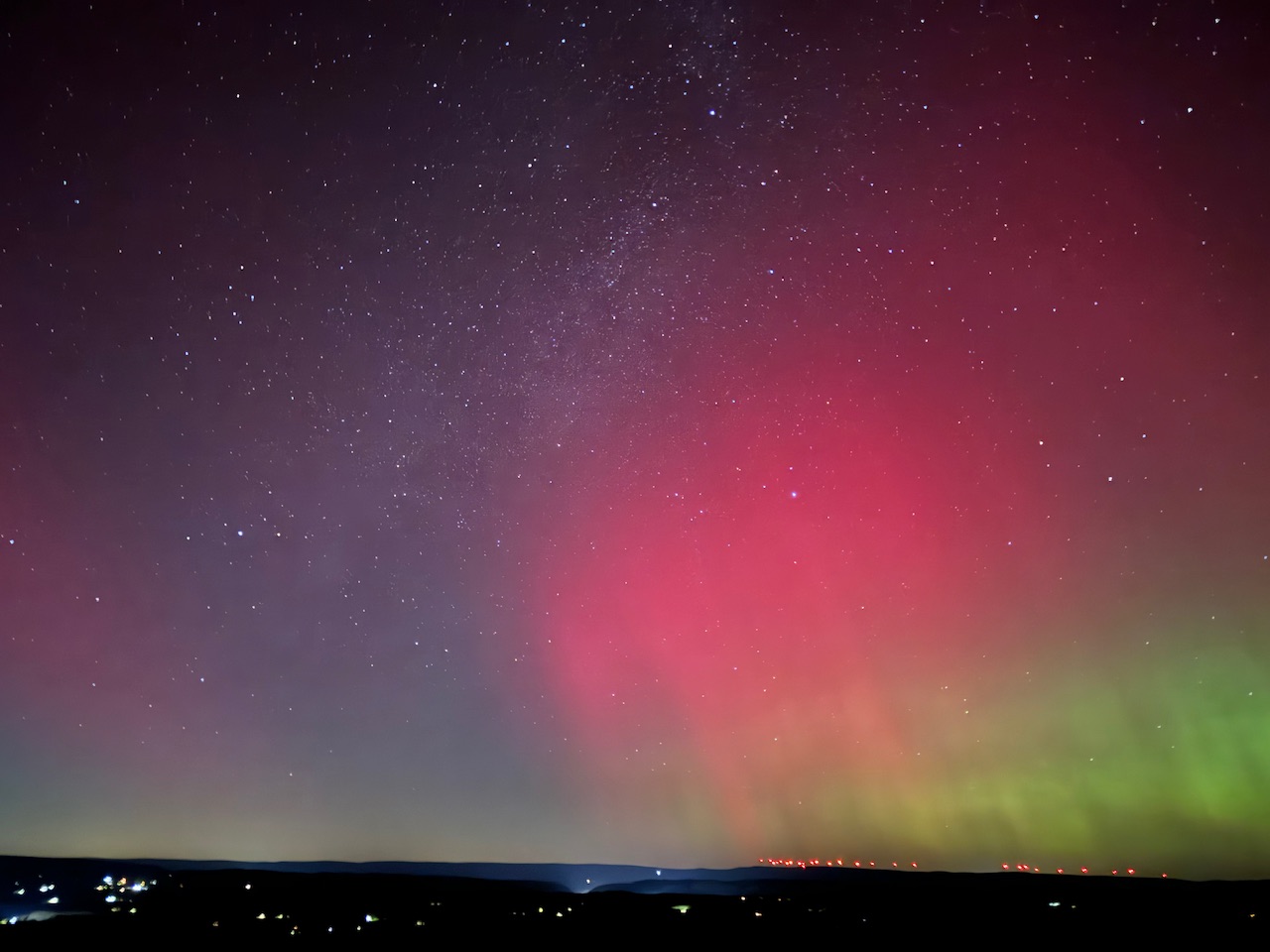
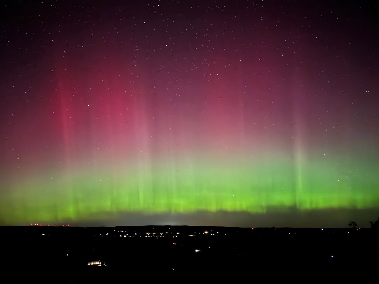
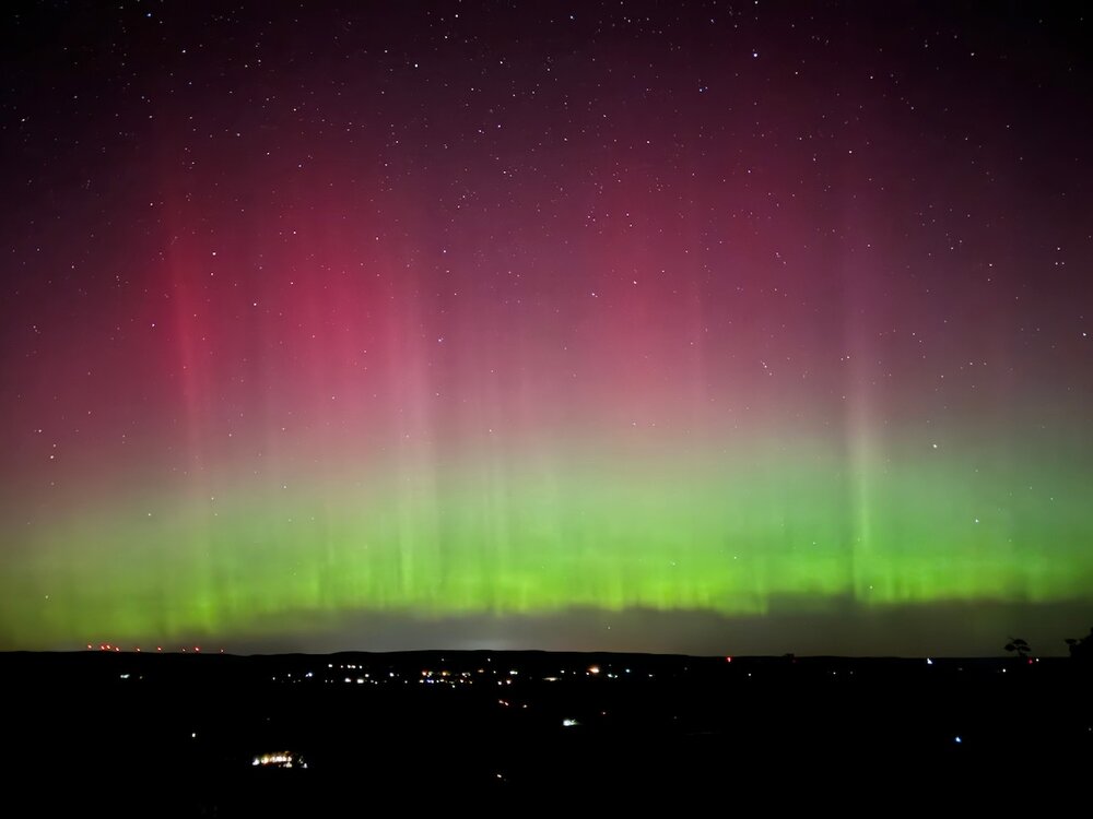
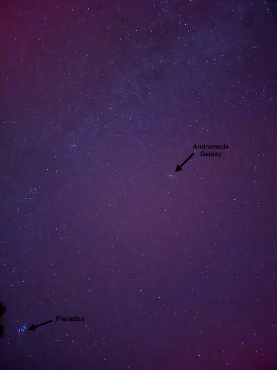
Absolutely incredible viewing tonight. From the top of Tussey Mountain (NW Huntingdon Co) in Rothrock State Forest the aurora and its colors were easily viewable with the naked eye. With the moon having set earlier you couldn’t have asked for better sky conditions. Pics were taken about an hour ago. iPhone 15 Pro with 3-10 second exposure and no edits. I also got good videos of it moving and pulsing. f

-
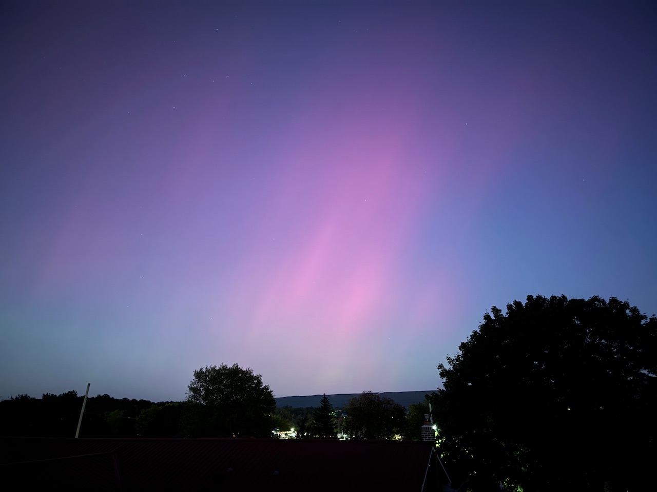
I was just about to post, the aurora is already visible here. Gonna be a fantastic night to view it.