MAG5035
-
Posts
5,882 -
Joined
-
Last visited
Content Type
Profiles
Blogs
Forums
American Weather
Media Demo
Store
Gallery
Everything posted by MAG5035
-
Yup, that December 92 nor'easter pretty much started that portion of the mid-90s where the central counties were the place to be for these big coastals (Dec '92, Mar '93, Mar '94, Jan '96). With December 11-12. 1992, the crazy part about UNV's 18" was the fact that precip turned to rain in the middle part of the storm there (LSV had some decent snow but a lot of rain), while SW of there in AOO and into the Laurels stayed all snow and there was a 36" total in Somerset County. We definitely will have a better airmass in place for this one, however the 500mb feature was much more pronounced on Dec '92 (closed 500mb low). There's a whole bunch of youtube videos of TWC during that storm that I found last winter. Jeff Morrow reporting in Breezewood getting blasted with snow. These videos def helped last winter lol. https://www.youtube.com/watch?v=R-ueyO15a2o&t=31s
-
Haha well that's good to hear, I almost wanted to retroactively give myself a weenie tag on that post I made early this morning. There is definitely differences between this prospective event and that one and the excessive swath is not going to be placed the same (likely NW of the big cities) and probably not as widespread. I was commenting mainly on the u wind (easterly fetch) component. Big time u wind anomalies are a hallmark of a big Mid-Atl/NE snow event.
-
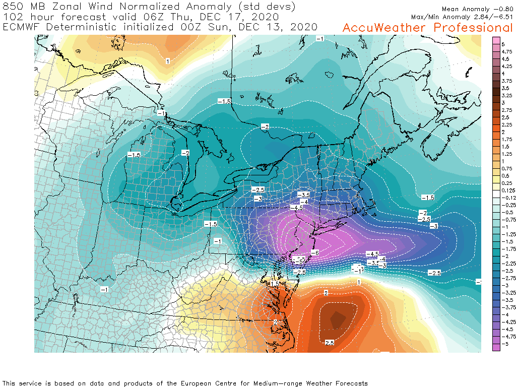
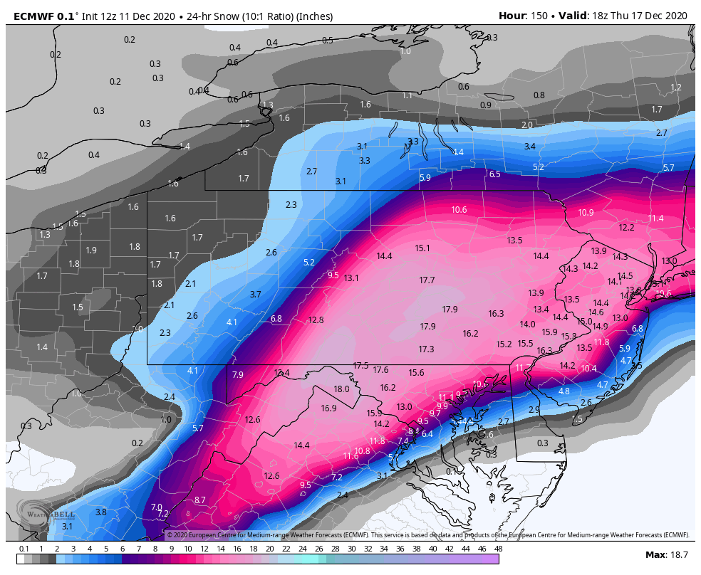
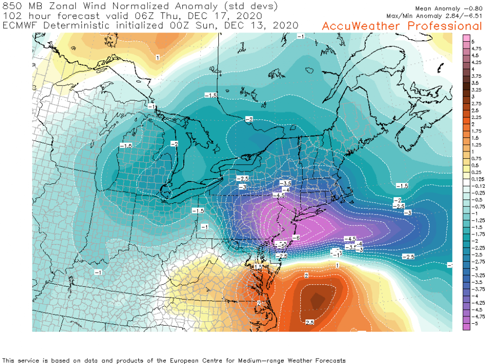
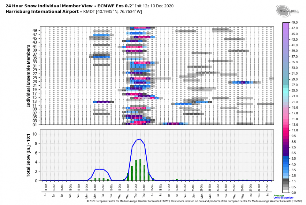
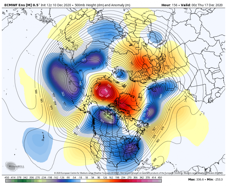
I dunno, looks more like a C-PA forum special lol. Euro places ground zero of the deform up between I-99 and I-81 up through IPT into NE PA. Until this gets into short range, I'm only posting 10:1 maps if I throw up a snow map. Just trying to keep the top end capped while addressing the storm til we get into short range. But with that said, gotta acknowledge that models are dialed in to an excessive event right now... with every major op (CMC/EURO/GFS) having a 20"+ swath. The key is WHERE that excessive swath is located, which models haven't really nailed down yet. These Kuchera maps are nuts. IPT for example is 33.8" on 2.09" of QPF. That's a 16:1 ratio, which is probably doable wherever that intense deform sets up given pretty decent column temps where there's going to be monster 700mb lift, and there's a big swath of these accums in central to NE PA. Even a more standard 12-13:1 ratio is in excess of 2 ft. The knock on Kuchera is it calculates ratio solely on temperature by simply calculating a ratio from the warmest part of the lower 500mb of the column. It doesn't factor snow growth characteristics, omega, etc like BUFKIT data or the Cobb method would show. I have access to a Cobb map from the Euro and it's just as crazy amount wise but a touch east with pretty much I-81as the axis line, likely matching up where the best lift actually is. Actually gives Harrisburg an even bigger total than the Kuchera. Crazy numbers these models are putting out. Lastly here's the Euro's U wind anomaly at 850 mb at 102hrs (height of the event). Basically this is an indication of the strength of the easterly fetch. A highly anomalous easterly flow is a hallmark of the big ones. A -4 to -6 anomaly is through the roof... that's Feb 5-6, 2010 level stuff in terms of that indicator... key phrase being "in terms of that indicator". Should note GFS has similar anomalous flow, just not penetrating into PA as much as the Euro, which is why it's heavy swath further southeast.
-
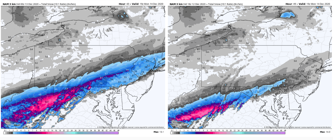
On a run to run comparison, there was a big difference in heavier snowfall placement outside of the LSV (NW of H-burg into central/northern PA) with the 0z GFS vs 18z. Not really reacting too much to it as it's one run on one model, just pointing out the difference. As a whole, this is becoming more of a figuring out how much of the subforum is going to get slammed with a big snowstorm type thing. The big forecast challenge to me right now is the actual central part of the state and how much of it gets into the more excessive snowfall. I just feel even if we had the more inside scenario that gets mixing into York/Lancaster, it would be a transient issue that goes back to snow as the low deepens and moves up the coast.
-
Hmm, well at least on the WeatherBell products it appears the op data for the GFS and Euro is 0.25º and 0.1º respectively while their ensembles are both at 0.5º resolution. Without getting into a whole thing on GIS/mapping/degrees to meters conversion, the short answer would be yea the ensembles are run at a lower resolution (higher degree number). The high res Euro at 0.1º would be a bigger resolution difference vs it's ensemble. So I guess it could be implied that the lower resolution could flatten mesoscale features and thermal boundaries a bit and that difference could show with coastal low development, especially with how warm the water is off the eastern seaboard. Also, ensembles aren't going to see CAD as well as an op or especially a meso model for that same general reasoning. The higher resolution of the ops might be promoting a more explosive coastal response (and also closer to the coastline) just simply on the premise of modeling a sharper clash of warm vs cold. Given the +SST anomalies present on the eastern seaboard and a fairly respectable cold air air mass being supplied by the Canadian high, it may be wise to lean that direction with trying to blend guidance. Ultimately, I'm not sure how much the resolution difference actually plays in the grand scheme of things, as an ensemble is made of individual members that have their own specific conditionals to form a mean within a range of possible outcomes, which pretty much can have a similar effect as lower resolution flattening features out. Thing with ensembles is we're typically looking at them to get a handle on overall larger scale things with these events (QPF fields, pressure/height fields, accumulation probabilities, etc).. especially at this middle range where we don't have our short range or meso models in range quite yet.
-
I was going to address ENSO and the pattern going forward in a post at some point and then all heck went loose with what were looking at this coming week. So far, I haven't seen any sustained signs of an imminent weakening of the Nina. Daily SOI values and 30 day average SOI has been firmly positive (positive indicates Nina state) and SST's have been relatively steady. ENSO 3.4 has warmed a tad in last weeks update but still -1.1ºC (moderate) and the SON three month average came in at -1.2ºC. Three month averages are lagged, so when December is over and the OND average can be tallied, it's likely on track for a similar value to the SON average. Obviously, this is something to consider and watch evolve as we work through Jan. Right now though, the big driver of this snowy week that appears to be incoming is the development of a solid negative AO/NAO regime. This is a great time for this to develop as we're early in the winter and we don't have the fully mature mid-winter pattern where the Nina can rear it's ugly side at times. And of course, good blocking in that realm is a good counter to an active Pac jet (+EPO). If we can hang onto the -NAO/AO for awhile and keep the MJO at bay (out of any higher magnitude phase 4-6), we can take an occasionally imperfect but workable pattern thru the holidays to the New Year. But we shall worry about that after Thursday or so.
-
It was a concern I initially had, mainly because of timing and getting the systems too close together was my worry. As this has evolved the last couple days it doesn't appear to be as much of an issue, especially on the Euro. That has generally been the most aggressive model with northern extent on this first event and it's been subsequently pounding the Mid-Atl/NE with the main system regardless.
-
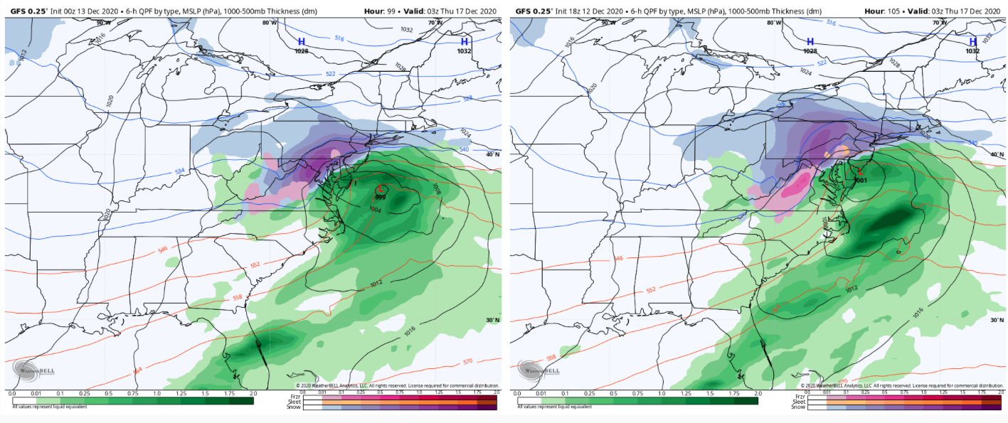
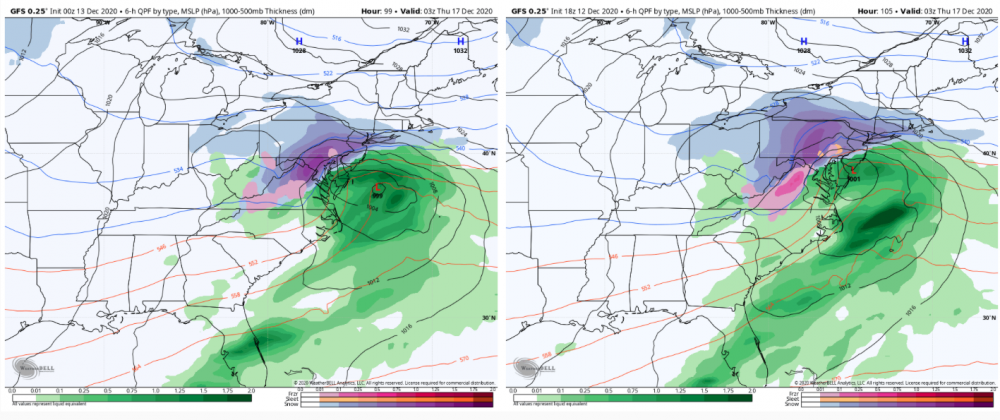
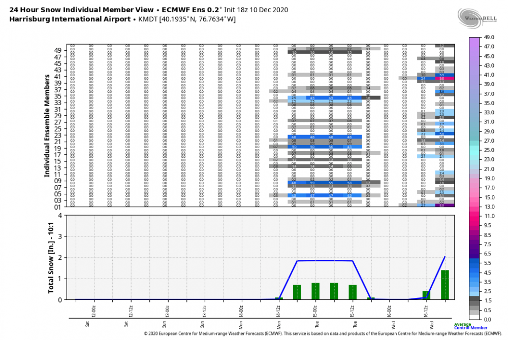
I've been away today and haven't had much time to scrutinize models too much, but vs the 18z NAM this first event is way more robust on the 0z. 0z on the left, 18z right

-
We’re definitely looking good at the moment, I’ve noticed the globals are starting to solidify the NW extent of the precip shield which is a good sign for getting west central PA and the Pittsburgh folks more involved. The Canadian op still seems the most SE with the axis of heaviest snow, but looks like the CMC ensemble align a bit more toward the GFS/Euro. Euro is def the most amped, pretty much representing a nearly best case scenario for most of our region save for perhaps a period of p-type issues in York/Lancaster. A simple blend of everything puts most of C-PA and all of the Sus Valley in a pretty good place. All of that for Wed/Thurs and the GFS/GEFS/CMC ensemble are showing more support for the Euro’s more robust initial wave and lighter snowfall potential in at least the southern tier of the state Monday.
-
Man I just looked at the Euro and almost fainted lol.
-
I'm going to wait a couple days to see where this goes before I start making comparisons, but I got a couple in mind.
-
The Ohio Valley low is going to be important for you and the western part of the state from the Laurel's west. The Euro had the stronger low I was posting about and it responded by getting better precip into western PA.
-
Well Euro is, snowy lol. What a hit on the eastern 2/3s of the state. Some snowmaps, these are 10:1 maps and i'm using 24 hr snowfall to separate the two potential events. This is Monday's wave, as Euro continues to support a snow event with that system: This is Wednesday/Thurs:


-
I'm not really worried about temps for any of us in here right now, we don't want to force the storm too far under us with how it's being modeled on it's coastal development starting off the Carolina coast and coming up. The Canadian flirts with having that heavy snow axis just southeast of a lot of us in here, the disclaimer being that this model has been the furthest southeast the last cycle or so (minor event yesterday at 12z) and it has really come back around. The Euro has seemingly been the most amped, and that has only introduced p-type issues to maybe the SE half of Lancaster for a part of the storm. We'll see shortly where we're at with the Euro at 12z. Really shouldn't be afraid of a bit more of an Ohio Valley low either. We have the setup for the big Miller B transfer to carry over a snow swath across most of PA. This is not going to cut, and we have a good high progged to be in place. A bit stronger of an initial low could imply a more robust precip shield associated with that and prolong the duration of the storm for especially the central and SW part of the state.
-
The Canadian's Kuchera map would be a good candidate for their snowfall forecast lol.
-
Lol, well the 0z Euro not only got some light snow into PA with Monday's storm.. but still crushes the I-81, US 15, and back to the I-99 corridor in central/eastern PA. Western PA more involved with at least 2-3" for Pittsburgh and surrounding SW PA. Some mixing in Lancaster Co. with an accumulation gradient NW-SE in the county. Def quite amped.
-
Storm's back on the Canadian at 0z although it only really catches the LSV below the turnpike. More of an I-95 storm, especially in the Mid-Atlantic region. This kind of represents my biggest fear with this storm potential given the magnitude of the -NAO being forecast. Certainly much more so than a cutter or mixer.
-
I was just looking back and I haven't had a snowfall greater than 2 inches since March 3, 2019. So heck yea, count me all in on Tom,Dick, and Harry WX's 20-40" inch snow forecast lol.
-
Don't want to get too greedy haha. Yea this Monday event could catch far southern tier but honestly I think i'd rather that stay out of the way and not end up somewhat deeper and slower as this 17th system has better potential to be a big C-PA wide event. I know I personally don't want to see something more suppressed or a forum dividing type deal out of something which could dump a good bit of snow given the setup being presented. If you look at the Euro's 12z ensemble mean at MDT, there's some members that get a snow event Monday. Those particular members subsequently are ones that show little or no snow for the 17th. Hard to tell with the 18z ensemble that only goes to 144 where the 17th event is just getting into, but you can sort of see the same general theme. 12z Run 18z Run
-
Wsmptwx FTW on the 12z Euro haha. The Kuchera map gave him about 30". This seems to have a pretty solid showing on the ensembles today, even on the Canadian ensembles where the op whiffed today at 12z. This potential event definitely has my attention now. That NAO over the top blocking driving the storm track down is definitely a beautiful thing (hopefully not too much of a beautiful thing). The decent 500mb feature and longwave trough being modeled that drives this doesn't look overly complicated either, e.g. needing a thread the needle phase to make it pop.
-
The GFS is def more miller B in it's evolution with the Ohio Valley low. I'd argue that scenario probably has more precip hanging back over most of the state, but the seemingly early takeover of the coastal definitely would take away from the actual central part of central PA and western PA in that scenario. Pretty close to last night's Euro. That looked like more of a straight miller A with only a little bit of surface reflection to the Ohio Valley. That probably could have more precip on its NW quadrant too. Not going to sweat those details though. Models are starting to see this particular threat and that's a step in the right direction.
-
Models are all over the place with features in this prospective period later next week, which is to be expected to at least some degree with the general split flow regime we're being presented. I think the models each showed their own individual way this could evolve, and everything's on the table here including the Canadian's big ticket item. They're pretty solid on the weekend system that cuts, which doesn't look too prolific with rain. After the frontal passage and reestablishing of seasonal air early next week it's a free for all. Euro has been occasionally toying around with a followup wave pretty close behind the weekend system. GFS/Canadian haven't been all that interested in that. They've been developing another wave late next week here and there with the Canadian obviously having the big one today. Euro hasn't shown much with that timeframe, actually seeming more northern branch dominant on today's 12z run. GFS has seemed to have had more cold air issues when it does present a storm solution with really not engaging the northern branch south enough. Kind of a worry of mine personally given that the forecast +EPO was seemingly the one detrimental teleconnection that could screw a storm up that does materialize. Suppression is also a concern with the right (wrong) timing of features given the -NAO forecast. I'd say I'm reasonably confident something eventually materializes at some point the next couple weeks with the said forecast -NAO/AO regime and overall lots of high heights near the pole, which might be just enough to overcome the +EPO and run a system under us or at least present us with some frozen precip in an imperfect storm scenario. It's definitely a "must score" situation as any longer term sustained -NAO/-AO is certainly not a given.
-
I doubt there will be the kind of complete and thorough shut down/stay at home we had back in the spring. I think new restrictions will target stricter limits on gatherings (or no gatherings outside of household), probably go back to takeout only for bars/restaurants, and perhaps reinstate some sort of capacity limits on grocery stores, bigger retail, etc. I'm speculating of course on those specific things, but Wolf had just said on Monday "there were no plans to go back to return to the red-yellow-green designations that were so controversial in the spring." I'm not sure how much of a difference that would make anyways really when a lot of spread could be being driven from private gatherings/parties. It really boils down to people themselves actually being reasonable and taking at least some degree of caution/responsibility. This part of PA is in rough shape. The next county over in Cambria, which includes Johnstown, reported Monday the 2nd highest positivity rate of any county over 100k people (per capita) in the COUNTRY over the last two weeks and over 100 deaths since the beginning of November. https://wjactv.com/news/coronavirus/grim-situation-in-cambria-county-as-covid-cases-explode-to-second-highest-rate-in-nation.
-
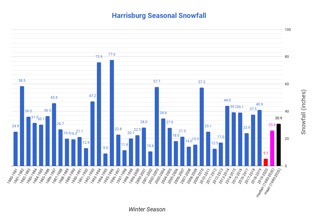
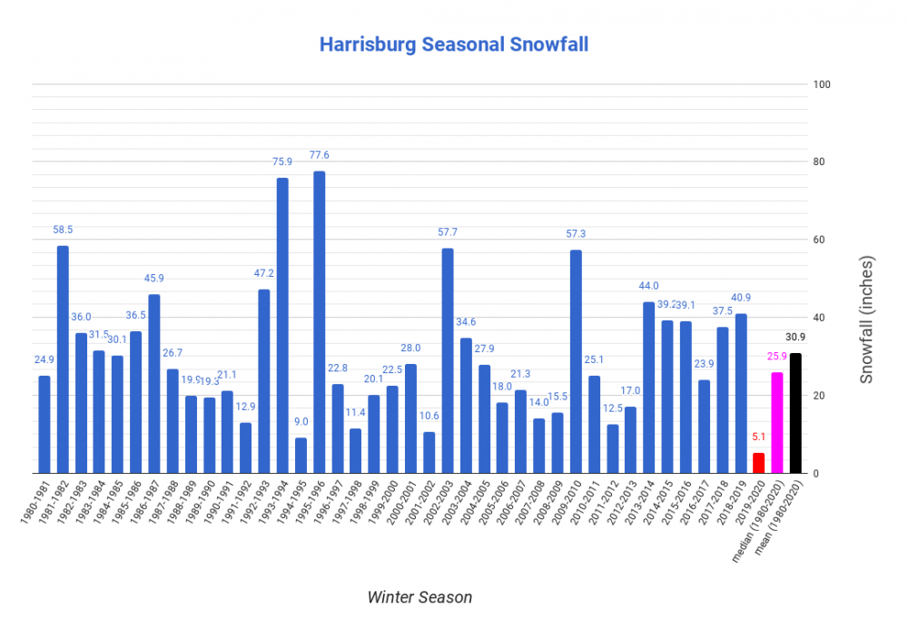
I think we should keep some perspective on the fact that Harrisburg has had 5 above average winters just in the last decade (5 of the last 7 winters to be more specific). I mean you can put the asterisk on 2015-16 that like 30 of the 39 inches came from Jonas but then you'd have to do the same thing for 82-83 that featured the 83 blizzard in that super Nino winter as well (25 of the 36"). So yea last year sucked, I think we're all aware of that. But I can pick out collective bad periods (88-92, 96-02, 05-09, 11-13, etc), or overall just point out that in this 40 year chart that 23/40 were below the mean and close to half (17 winters) were 75% or less of the mean. If we end up stringing together a few lackluster winters in a row the next couple years, it's definitely not something that hasn't happened before. Obviously it's a different story if we stack up several winters in close proximity as historically bad as last winter, but until such a point I look at last winter as an anomaly where an even more anomalous weather pattern (unprecedented +AO regime) had a big part in it.
-
Not until parts of VA probably see their first light snowfall of the season tomorrow lol. Overall pessimism for the eastern US has been the general consensus I've seen of outlooks (even JB) for this winter. With a solidly moderate La Nina ongoing, the tendency is for the MJO to favor 4-5 as we settle into the the main part of winter. Not necessarily something that ultimately results in a complete non-winter, but could mean the base winter pattern in the east favors above average temps (eastern ridge) more often than not. This is something I anticipate being an issue that probably ruins a period of prime winter real estate at some point in Jan/Feb if we flare up a strong MJO pulse through 4-6. Again, that in itself doesn't mean we won't see anything at all or periods where we have a favorable setup. I mean, the dreaded high amplitude eastern ridge favoring MJO pulse doesn't necessarily have to materialize either. But that's what these stronger Ninas like to favor historically. As I've mentioned in a couple posts, I expect a season about 75% of normal in most of PA with the Laurel's/NW seeing the best chance of a near average season. It's not a deal breaker by any means but what happens in December weighs heavily on that thinking as I'm banking on a fast start this month with perhaps one or two widespread events that get all of us off and running. From about 5 miles west of my house at the start of the Laurel's to Pittsburgh/western PA, mission accomplished so far there with early last week's storm and associated LES/upslope. For all of us in this subforum, well we just missed lol. And I really haven't liked the pattern alignment for us that ultimately set up for yesterday's coastal in New England and is setting up tomorrow's minor event that will be well south of PA. The positive orientation of the axis of the sprawling ridge in the western/central US into Canada just isn't allowing the dig we need out of the northern branch IMO. Yesterday's coastal was primarily a southern branch event that got some late phasing way too late for us and as a double whammy, the northern stream orientation didn't allow for a cold air mass for this event, depending mainly on dynamics of the rapidly deepening coastal to get the swath of snow to the New England folks that were lucky enough to see it. So now of course that we're actually settling in a colder regime tonight and dropping a shortwave straight out of Canada, the orientation is such that the partial phasing of features are going to force the developing coastal way low and out to sea with the press of that sprawling ridge. So despite some opportunities, C-PA and the LSV ends up with a swing and a miss for the opening week of December. We moderate back above average late this week after a few chilly days as that ridge eventually pushes into the eastern US. It's likely we're going to have to deal with another cutting system near D7 to perhaps reset things back to getting another period of opportunity the following week. In terms of teleconnections, there is some good there. Models have been generally favoring somewhat negative NAO and AO and while we lose the big +PNA, it may be more neutral than outright negative depending on which ensemble has their way. MJO influence looks dampened as modeling has been keeping that within the circle. The big sticking point I"m seeing right now is the EPO being forecast to swing positive, which could imply a strong Pac jet and perhaps Pac influence on our temps and/or storm track unless we can counteract with higher heights in the NAO realm/eastern Canada to force the northern branch storm track down.