

MAG5035
-
Posts
6,078 -
Joined
-
Last visited
Content Type
Profiles
Blogs
Forums
American Weather
Media Demo
Store
Gallery
Everything posted by MAG5035
-
Central PA - Jan 31 to Feb 2 Winter Storm
MAG5035 replied to MAG5035's topic in Upstate New York/Pennsylvania
For AFTER this storm wraps up tomorrow. I just looked at the model guidance out beyond today and figured I'd get this rolling for discussion.. cuz there's going to be plenty to talk about after this storm's over. -
Getting this started for after the current storm, the opening two weeks of February are looking slightly active.
-
Central PA - Jan 31 to Feb 2 Winter Storm
MAG5035 replied to MAG5035's topic in Upstate New York/Pennsylvania
Wow that's nuts, and that band looks like it's going to deliver a good bit more if that's the kind of rates your getting. -
Central PA - Jan 31 to Feb 2 Winter Storm
MAG5035 replied to MAG5035's topic in Upstate New York/Pennsylvania
Steady snow finally restarted back this way, moderate. -
Central PA - Jan 31 to Feb 2 Winter Storm
MAG5035 replied to MAG5035's topic in Upstate New York/Pennsylvania
State College is looking pretty decent at the moment. Hoping that heavier area between here and Harrisburg is able to get back to the I-99 corridor, it's making a good press so far. -
Central PA - Jan 31 to Feb 2 Winter Storm
MAG5035 replied to MAG5035's topic in Upstate New York/Pennsylvania
You can see the expansion of the comma head into eastern PA on the IR and WV imagery. https://weather.cod.edu/satrad/?parms=regional-northeast-14-48-1-25-1&checked=map-glm_flash&colorbar=undefined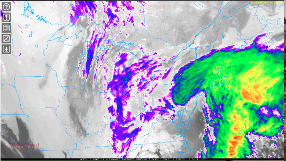
-
Central PA - Jan 31 to Feb 2 Winter Storm
MAG5035 replied to MAG5035's topic in Upstate New York/Pennsylvania
How much have you had? Looked like several 7-8" reports up around State College. -
Central PA - Jan 31 to Feb 2 Winter Storm
MAG5035 replied to MAG5035's topic in Upstate New York/Pennsylvania
I might end up being the only one that doesn't lol. Eyeing up that band between you and me trying to pinwheel down this way. -
Central PA - Jan 31 to Feb 2 Winter Storm
MAG5035 replied to MAG5035's topic in Upstate New York/Pennsylvania
You look like your going to be in great shape for awhile. -
Central PA - Jan 31 to Feb 2 Winter Storm
MAG5035 replied to MAG5035's topic in Upstate New York/Pennsylvania
Up to 5.5" after some half decent steady snow for an hour or two. Pretty light right now (looks like a bit of a subsidence zone overhead attm) and there was some partial sun through the clouds not too long ago. Just no consistent good rates with this event here up to this point. -
Central PA - Jan 31 to Feb 2 Winter Storm
MAG5035 replied to MAG5035's topic in Upstate New York/Pennsylvania
They may mix for a time in the city, northern Jersey though? Yea more than likely. We're not going to get the direct enhanced forcing death band they're getting but this is eventually going to translate into PA in the form of enhancing the deform precip already over PA and perhaps a less intense (but still heavy) embedded band extending into the eastern half of PA somewhere. Personally not ruling out this setting up even further northwest (ala December storm) either. Near term guidance is eventually going to see it and get better placement on it later this afternoon, I dunno how much stock I'd put in the globals at this stage in the game trying to place meso features like this. -
Central PA - Jan 31 to Feb 2 Winter Storm
MAG5035 replied to MAG5035's topic in Upstate New York/Pennsylvania
Yea it was definitely slow going haha. By the time I fell asleep late last night I had 2.5" to show for 15 hrs of mostly light snow. There looks like a pretty good batch of heavier precip on radar heading for southern Huntingdon County south of 22. -
Central PA - Jan 31 to Feb 2 Winter Storm
MAG5035 replied to MAG5035's topic in Upstate New York/Pennsylvania
Snowing pretty decently currently, likely some of the best rates of the storm. Wind kicking up too. -
Central PA - Jan 31 to Feb 2 Winter Storm
MAG5035 replied to MAG5035's topic in Upstate New York/Pennsylvania
I cautioned last night about the widespread nature of big totals getting back deep in C-PA on models like the 12k NAM while also noting that near term stuff like the HRRR probably wasn't seeing the deform shield well enough.. which looks reasonable so far this morning. I think some bigger totals do get back into C-PA but probably in a narrower area within most of the Sus Valley into the central counties seeing more moderate gains today. -
Central PA - Jan 31 to Feb 2 Winter Storm
MAG5035 replied to MAG5035's topic in Upstate New York/Pennsylvania
Cleared my one board for a 24hr snowfall, which is 4.7". Light to moderate snow and 25ºF. -
Central PA - Jan 31 to Feb 2 Winter Storm
MAG5035 replied to MAG5035's topic in Upstate New York/Pennsylvania
Light to moderate rate currently I got a uniform 2.5" on my measuring spots. I put a second board out to clear at 24 hrs tomorrow morning. A lot of this afternoon had pretty light snow but 2.5" in about 15 hrs is definitely playing the slow game lol. -
Central PA - Jan 31 to Feb 2 Winter Storm
MAG5035 replied to MAG5035's topic in Upstate New York/Pennsylvania
Back to the discussion at hand, namely the ongoing storm... I still think the focus of the biggest totals will be that Lehigh Valley area of far eastern PA in northern half of NJ/NYC. And really the NAM still reflected that.. but the 0z run really hooked up with the major deform band reaching far back deep into C-PA. I'm a bit suspect of such a widespread area of a foot plus so far back like the 12k NAM has, but I do think the deform shield is probably being undermodelled on near term guidance like the HRRR. But remember.. HRRR goes out to 18 hours except for the 0,6,12,18z runs and we're still not really at the time when this deform from the deepening coastal gets flung back into PA at the end of the regular HRRR runs. And I'm more looking at other short term guidance for anything out past that anyways. The major features (850/700 lows) are well placed to go along with a very robust 850mb jet pointed into eastern PA so there's likely going to be a stripe of more significant totals.. just not sure on how widespread. -
Central PA - Jan 31 to Feb 2 Winter Storm
MAG5035 replied to MAG5035's topic in Upstate New York/Pennsylvania
I'm talking about several runs including all of Friday with the op being south and ensemble mean barely getting the 6" line above the mason-dixon line. That 30-40" solution in VA/DC was a couple days before that. Nowhere did I say I discounted it... I just said I didn't think it was superior to other guidance the few days leading up and it wasn't. -
Central PA - Jan 31 to Feb 2 Winter Storm
MAG5035 replied to MAG5035's topic in Upstate New York/Pennsylvania
Not wrong though, I don't think it was overly superior to other model guidance trying to reel this thing in the last few days. There was that particular run he referenced where the bullseye was in northern VA but it also spent a whole model cycle being south with the 0z Friday run missing a chunk of the Sus Valley and the very area of eastern PA and northern NJ targeted with what will likely be the biggest totals (2'+) was only getting a trace at best. -
Central PA - Jan 31 to Feb 2 Winter Storm
MAG5035 replied to MAG5035's topic in Upstate New York/Pennsylvania
Looks to be up over 2" now, moderate snow. On the southern end of some enhancing on the radar. Best snow has seemed to be residing in the north-central between UNV-IPT and NW of that line a bit so far this evening. Also another band of imbedded heavier snow working up from Frederick up toward York/Lancaster. -
Central PA - Jan 31 to Feb 2 Winter Storm
MAG5035 replied to MAG5035's topic in Upstate New York/Pennsylvania
About 1.5" total so far. Steadier snow has finally got here in the last hour. -
Central PA - Jan 31 to Feb 2 Winter Storm
MAG5035 replied to MAG5035's topic in Upstate New York/Pennsylvania
Nice burst of snow after what has been a pretty quiet afternoon (only light snow of the "for show" variety). Big flakes. Should be getting into some steadier stuff in the next hour or two. -
Central PA - Jan 31 to Feb 2 Winter Storm
MAG5035 replied to MAG5035's topic in Upstate New York/Pennsylvania
Houtzdale too, although I guess that's only 5 miles down the road. -
Central PA - Jan 31 to Feb 2 Winter Storm
MAG5035 replied to MAG5035's topic in Upstate New York/Pennsylvania
Hard to ignore the trend on guidance centering the biggest amounts on far eastern PA/northern half of NJ into NYC with the coastal low getting captured a bit higher up the coast. Now when i say "biggest amounts" I"m mainly talking about the excessive stuff (20+). I still like the general 8-14" in our region, but we're going to have to watch the southern tier and NW part of C-PA for some bust potential either direction as well as a zone TBD that could see higher amounts than the said 8-14". As mentioned, the most intense deform from the coastal winding up targets far eastern PA/Nj/NYC, but the overall fetch and likely extension of this deform is still going to reach back into C-PA and questions are where and how intense? You look at models like the 3k NAM and RGEM and they actually arc the best snow with this more through northern/central, while Euro/GFS runs southern third of the state. I'm not sure the near term guidance (HRRR) is robust enough with the precip shield/banding later on tonight into tomorrow but there's a lot to be determined yet and HRRR (outside of the 0,6,12,18z) doesn't even reach out to where the coastal really winds up yet. Also have to monitor the slot far southern tier LSV and maybe some mix while precip's light but worst case scenario I still expect at least 5-8". Again though, the overall picture is this continues to look like a long duration general 8-14" snowfall over the area. Ratios. Taking a rough gauge of the latest Euro snowmap, for instance... The big amounts stretching back deep into C-PA are driven more by high ratios while the big amounts in the Lehigh Valley into NJ are driven by QPF (likely the better bet to realize widespread big amounts). This is also notable on the RGEM too. Not to say there won't be notably higher ratios late in the storm, but I think it will be narrowed down where the bands set up at that stage of the storm inside of the overall precip shield. If your running a steady light to moderate rate outside of heavier bands, probably going to continue to have 10-12:1 type ratios. Biggest takeaway, patience is definitely required for this event. -
Central PA - Jan 31 to Feb 2 Winter Storm
MAG5035 replied to MAG5035's topic in Upstate New York/Pennsylvania
Saw flurries start as early as about 5am this morning snow but really didn't get going til about 9am this morning. Currently light snow and 1.3" on the ground. I'm not really seeing many surprises in the early going. Guidance has had this starting slow for days and that's what its doing. Near term stuff has had the initial surge of snowfall followed by a bit of light period while the precip shield rebuilds from Ohio and pushes into PA later this afternoon, which judging by radar trends seems on target.


