MAG5035
-
Posts
5,837 -
Joined
-
Last visited
Content Type
Profiles
Blogs
Forums
American Weather
Media Demo
Store
Gallery
Everything posted by MAG5035
-
December 16 2020 CTP Snowstorm Disco and Obs
MAG5035 replied to pasnownut's topic in Upstate New York/Pennsylvania
And the crazy part was State College just missed the band that pretty much could've doubled the amounts that were reported in and around the State College area, which were already big amounts. The 6z and early 12z guidance yesterday right when the storm was beginning had it there. Nothing had that deform band going as far W and NW as it did in the central/north central counties, and at the same time it appeared the coastal low took the somewhat less tucked in track. One thing to give the models credit for though was the amounts. I personally thought the 35-40+ amounts that popped up were probably a bit much given the steady system progression, but apparently not lol. Everything was showing that 2-3' swath for a few days, very reminiscent of Jan 2016 in that regard. Miller B's don't get much love in this region, and especially in the neighboring subforum (Pit/Western PA) for various reasons. That was pretty much what we had here though, a rather weak primary low transferring to a coastal low. Miller B's can produce a big snow swath through PA in the right setup and we had it for this one. A true miller A coastal low tracking from off the SC/NC coast and coming up probably would not have gotten the good stuff back so far into the western half of PA. -
At any rate on to the weather going forward. I'm not seeing too much system wise between now and Christmas, other than maybe some kind of weak system at the beginning of this coming week. Temps are meh and setup kind of favors western and Laurels if there's any notable precip. Models have been pretty solid on an arctic cold shot crashing through on or about X-mas morning. Difference between models are on handling the frontal system. GFS has generally had an anafrontal look to it, with a rain to snow scenario with the frontal boundary. The Euro has a pretty dry frontal passage ushering in the very cold air. 12z Canadian had something insane that's not likely to happen, or at least I'd hope not. I don't think either the GFS or Euro scenario will completely erase much, if any of the snowpack even in most of the Sus Valley. As such, chances of a white Christmas (inch or greater on ground X-mas morning) seem pretty good. Zonal flow regime predominant for the next week, which will keep temps pretty seasonable. Also helping will be the presence of our new snowpack, which aside from the wildly varying top end amounts managed to give all of us in here and our western PA friends 10"+ plus sleet to anchor the pack in the LSV where it would be more vulnerable to a WAA intrusion. But a couple days of 40 or so this time of the year isn't going to melt things a ton, especially where the sleet fell. The only day/period that may be notably warmer is around the 23rd with that approaching frontal system. That may have more luck advecting warm air on a SW flow on the other side of the Laurel's but may not do much in central/eastern. Pattern wise going to the start of the New Year, it seems pretty workable. We neutralize the +EPO, which by the way was pretty positive for this storm that just happened. Build a bit of +PNA in the X-mas period with the cold shot. NAO/AO neutral to slightly negative. MJO staying in the circle on most guidance. I don't really see any kind of an overwhelming influence from any particular teleconnection. So if models latch on to any particular system, especially week between Xmas and New Years.. I'd like our chances of keeping the wintry going.
-
I was looking back at PennDOT announcements for the district that happened in. They had their section of I-80 on a Tier 1 restriction which restricts tractors without trailers, light or unloaded trailers, motorhomes, personal vehicles with trailers, cargo delivery trucks meeting the definition of a commercial vehicle, school buses unless chains are used etc. I didn't realize they had a 5 tier restriction guideline. At any rate at some point (think it was after the accident), they put it up to a tier 3 from the Bellefonte interchange (I-99) east through the rest of Centre and Clinton.. which restricts all commercial vehicles except loaded single trailers with chains or approved alternate traction device. https://www.penndot.gov/TravelInPA/Winter/Pages/Vehicle-Restrictions.aspx Either way given the ample advance warning of this storm and lane/speed restrictions in place, I'm kinda surprised such a massive crash could occur. Doesn't anyone use a CB anymore? Rapidly changing conditions with a squall is one thing.. but a large snowstorm is a pretty constant condition with reduced visibility and traction.
-
PSP Update on that I-80 wreck in Clinton County yesterday, 55 commercial vehicles and 11 passenger vehicles. https://wjactv.com/news/local/police-interstate-crash-with-dozens-of-vehicles-kills-2
-
December 16 2020 CTP Snowstorm Disco and Obs
MAG5035 replied to pasnownut's topic in Upstate New York/Pennsylvania
This thing kicked it into an even higher gear when it got into NWS BGM territory. Multiple counties with 40"+ reports, including right around NWS Binghamton themselves. Incredible. -
December 16 2020 CTP Snowstorm Disco and Obs
MAG5035 replied to pasnownut's topic in Upstate New York/Pennsylvania
My mom forwarded me pics from a couple of her friends up in her hometown of Renovo, Clinton County where that band sat for awhile last night. K&L Auto just outside of town Tamarack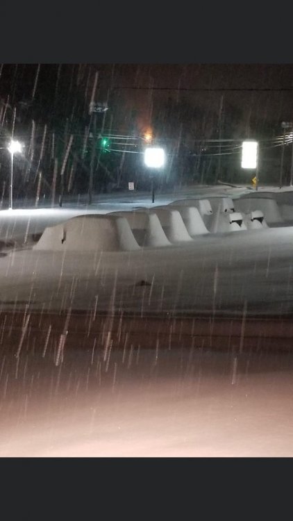
-
December 16 2020 CTP Snowstorm Disco and Obs
MAG5035 replied to pasnownut's topic in Upstate New York/Pennsylvania
Where that band set up and sat last night over those north-central counties got in excess of 2 feet, so a 3+ foot total somewhere isn't out of the realm of possibility. The models having the 20-30+ swath for days ended up being right in the end, just that it ended up being more W than what any model had and then it did arc over to Williamsport.. although the worst of that band was actually north of IPT for awhile and they still got what they did. I don't know what happened here. Looking at you guys' totals this morning, my 10.7" is on par with @Itstrainingtime and the Lancaster folks with some of the ones around Harrisburg actually doing slightly better even with the sleet. This was a big bust for me personally, as I was expecting mid teens here and when yesterday mornings models came in at the beginning of the storm I thought 20" was realistic. I think that intense band setting up just to the west of here for awhile got me into a subsidence zone. I never got the 2-4/hr rates. I'm still happy, it's a double digit snowfall in December either way. Roads are still a mess this morning and my back street hasn't been plowed yet. Couldn't imagine folks that ended up with more than twice of what I got. -
December 16 2020 CTP Snowstorm Disco and Obs
MAG5035 replied to pasnownut's topic in Upstate New York/Pennsylvania
The February 2003 storm (PD2) had 18.2" measured on campus. And there was a sneaky forgotten about nor'easter Jan 6, 2002 that dumped about 13-15" in UNV. I think the Feb 5-6, 2010 storm was also about 13-15" in the UNV area as the really high totals were just south. So sounds like you guys did about as good or better than the Feb 2003 event, that's pretty good company to be in. -
December 16 2020 CTP Snowstorm Disco and Obs
MAG5035 replied to pasnownut's topic in Upstate New York/Pennsylvania
10.7" was my final here. -
December 16 2020 CTP Snowstorm Disco and Obs
MAG5035 replied to pasnownut's topic in Upstate New York/Pennsylvania
Been back to a decent snow after a bit of a lull for awhile. Finally arriving at the 10" mark. -
December 16 2020 CTP Snowstorm Disco and Obs
MAG5035 replied to pasnownut's topic in Upstate New York/Pennsylvania
Definitely. Only question there would be if you get that 2-4 within the next hour lol -
December 16 2020 CTP Snowstorm Disco and Obs
MAG5035 replied to pasnownut's topic in Upstate New York/Pennsylvania
That’s awesome. 20 is probably doable for you. That main snow band is just sitting over rural Clinton and Lycoming. Renovo would probably be quite the place right now. -
December 16 2020 CTP Snowstorm Disco and Obs
MAG5035 replied to pasnownut's topic in Upstate New York/Pennsylvania
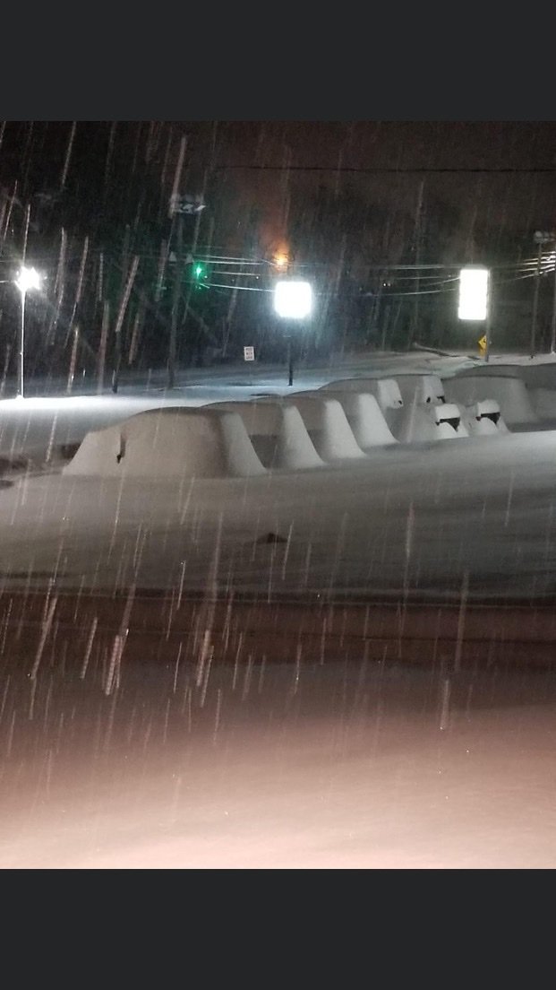
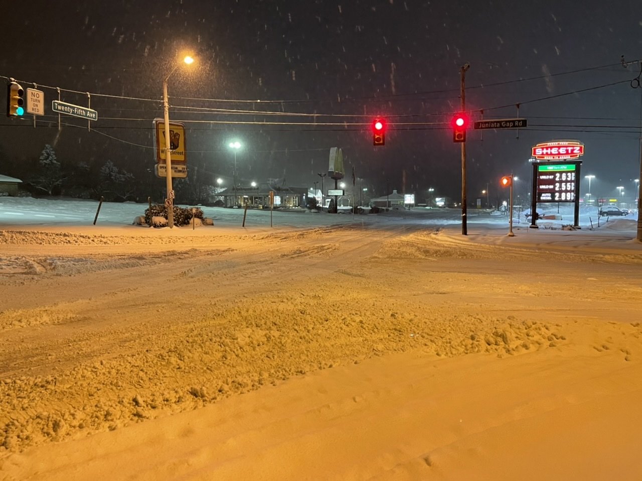
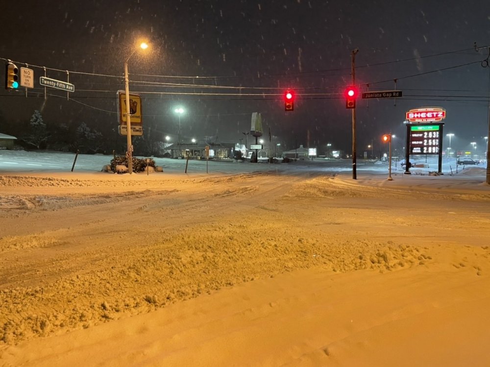
I Jebwalked on down to Sheetz just a bit ago. Prob gonna take a good part of the morning to get roads straightened up after the snow stops.
-
December 16 2020 CTP Snowstorm Disco and Obs
MAG5035 replied to pasnownut's topic in Upstate New York/Pennsylvania
Wow that's impressive, are you in State College? That's a pretty big difference from State College to down here in Altoona if so. I'm between 9.5"-10". Just didn't get those rates in that timeframe with the deform banding settling just west and NW of here. -
December 16 2020 CTP Snowstorm Disco and Obs
MAG5035 replied to pasnownut's topic in Upstate New York/Pennsylvania
1.3" of sleet?? Congrats in advance on the white X-mas lol. -
December 16 2020 CTP Snowstorm Disco and Obs
MAG5035 replied to pasnownut's topic in Upstate New York/Pennsylvania
Slightly higher than 850mb level, about 800-850 mostly. Here's a cross section of the NAM at 0z at it's 0hr initialization. Did the cross section from roughly Huntingdon county to Allentown with Harrisburg in the middle. That line for producing this cross section is drawn slightly south of Tamaqua. Doing one from here across to NJ with Tamaqua in the middle didn't have that patch of slightly above freezing air but that broad layer of near 0ºC. Likely was just a enough of a warm tongue to do the trick to get sleet.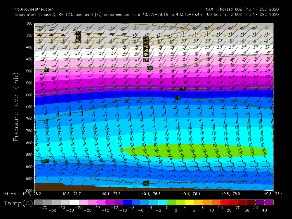
-
December 16 2020 CTP Snowstorm Disco and Obs
MAG5035 replied to pasnownut's topic in Upstate New York/Pennsylvania
@jim123 Yep the pivot is starting to become evident on radar. This def bodes well for at least State College. Need a bit of building near Somerset County to feel better about keeping the decent rates here in Altoona, but looks like it's trying to do that. -
December 16 2020 CTP Snowstorm Disco and Obs
MAG5035 replied to pasnownut's topic in Upstate New York/Pennsylvania
8.6" with heavy snow falling now. Bigger and fluffier flakes with this current burst of heavier. -
December 16 2020 CTP Snowstorm Disco and Obs
MAG5035 replied to pasnownut's topic in Upstate New York/Pennsylvania
Probably the next hour at least (edit: I'm talking just about the heavy band, not the rest of the event lol). I'm watching to see what that weak spot in returns does down in Somerset County and if we keep building some banding. Back to heavy snow here but probably not as heavy as there. -
December 16 2020 CTP Snowstorm Disco and Obs
MAG5035 replied to pasnownut's topic in Upstate New York/Pennsylvania
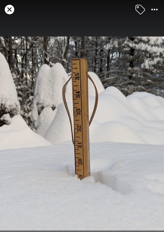
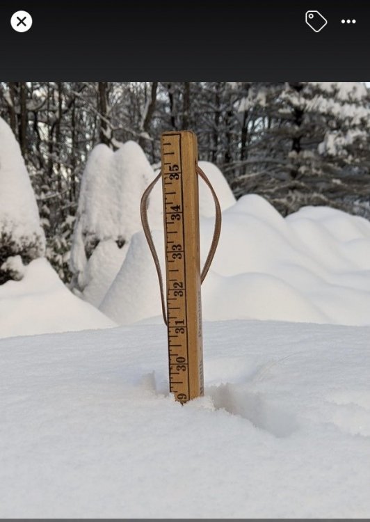
I see you had to switch to a bigger ruler haha. -
December 16 2020 CTP Snowstorm Disco and Obs
MAG5035 replied to pasnownut's topic in Upstate New York/Pennsylvania
Next couple hours are crucial but my chances for getting that high are slipping away the longer that band stays arced to my NW and north. It seems to be setting up over 2001kx over to just NW of IPT. @2001kx has to be getting crushed. This is the band that's going to see the excessive totals and it's setting more NW than any guidance had it earlier today. Up to 8" with moderate rates. Snowing decent but I probably lost my outside chance at 20". -
December 16 2020 CTP Snowstorm Disco and Obs
MAG5035 replied to pasnownut's topic in Upstate New York/Pennsylvania
You can see the dry slot on the IR, if you put it in motion you can see the comma head shifting towards the Sus Valley. https://weather.cod.edu/satrad/?parms=continental-conus-14-24-0-50-1&checked=map-glm_flash&colorbar=undefined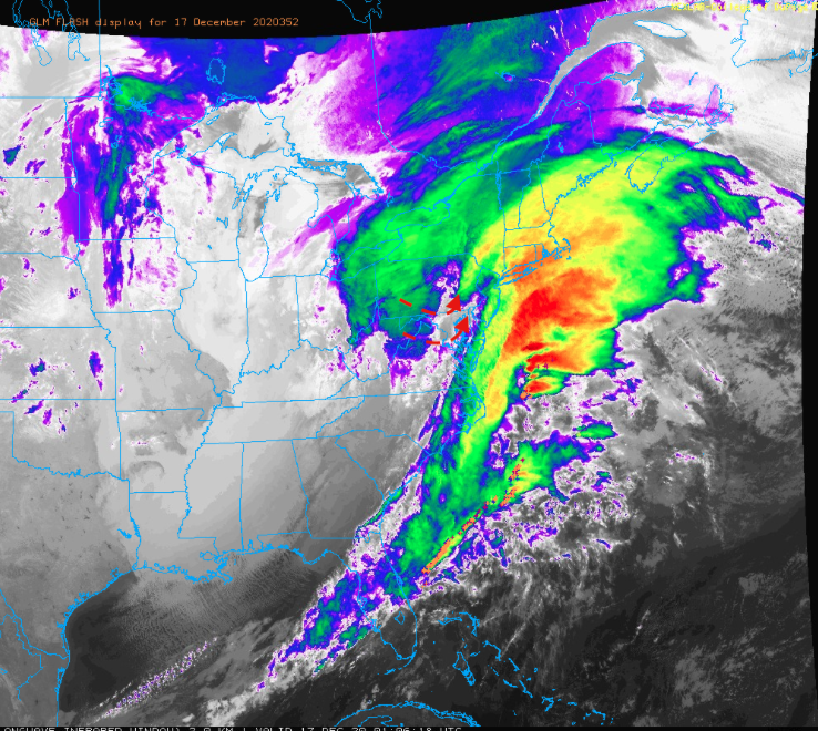
-
December 16 2020 CTP Snowstorm Disco and Obs
MAG5035 replied to pasnownut's topic in Upstate New York/Pennsylvania
Mesoanalysis has the low roughly on the southern tip of the Delmarva currently. So track doesn't look to end up as far NW as some models had it but the models like the Euro and especially NAM got the stronger warm nose aloft correct. I was def thinking mix in southern York/Lancaster but didn't think it'd get as far north as it did. That tremendous 850mb fetch likely had a big hand in that. I'd say things will probably get changed over once heavier precip starts shifting back into the Sus Valley (and also comes up from the SW by looks of the LWX radar). Likely within the next couple hours. -
December 16 2020 CTP Snowstorm Disco and Obs
MAG5035 replied to pasnownut's topic in Upstate New York/Pennsylvania
That's a nice band your set up in right now, it does seem these deform bands are setting even more NW than some of the more NW guidance had them. -
December 16 2020 CTP Snowstorm Disco and Obs
MAG5035 replied to pasnownut's topic in Upstate New York/Pennsylvania
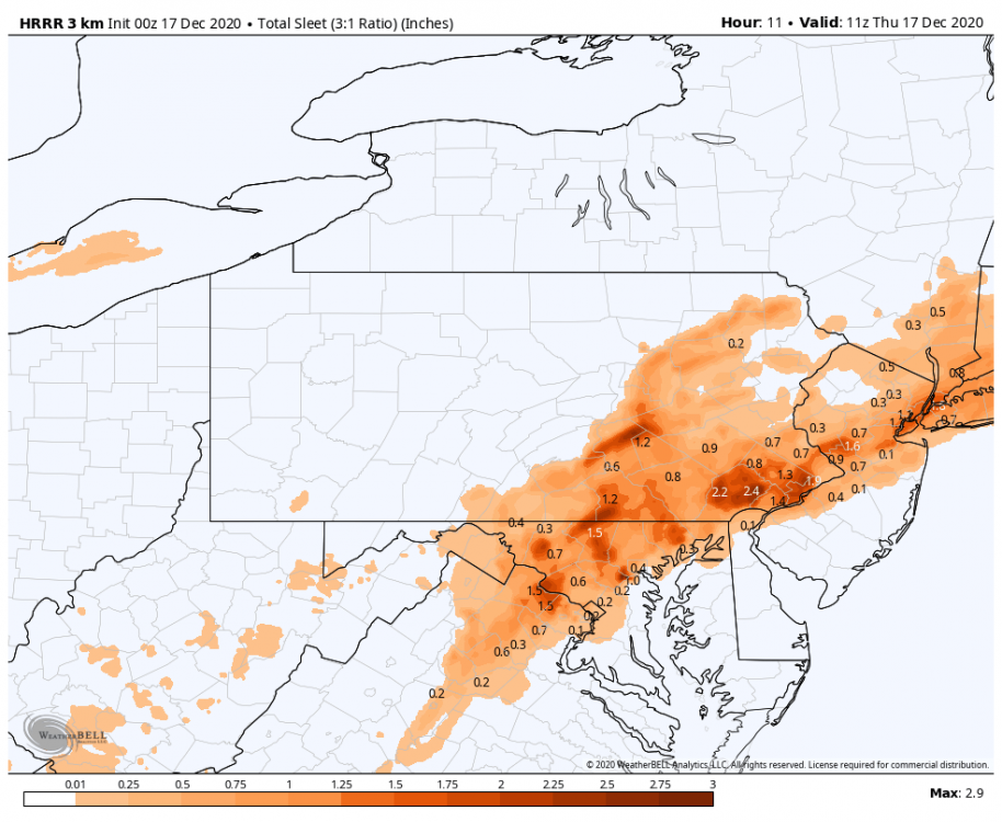
WeatherBell doesn't include sleet in it's snow map like TT does. There's a separate accumulation map for sleet (using a 3:1) map. Which brings the question, does anyone have any noteworthy sleet accumulations to report? Typically I'll measure and clear when a transition occurs and measure the sleet separately.