MAG5035
-
Posts
5,882 -
Joined
-
Last visited
Content Type
Profiles
Blogs
Forums
American Weather
Media Demo
Store
Gallery
Everything posted by MAG5035
-
I'll be curious to see where the Euro ensemble is with this today.
-
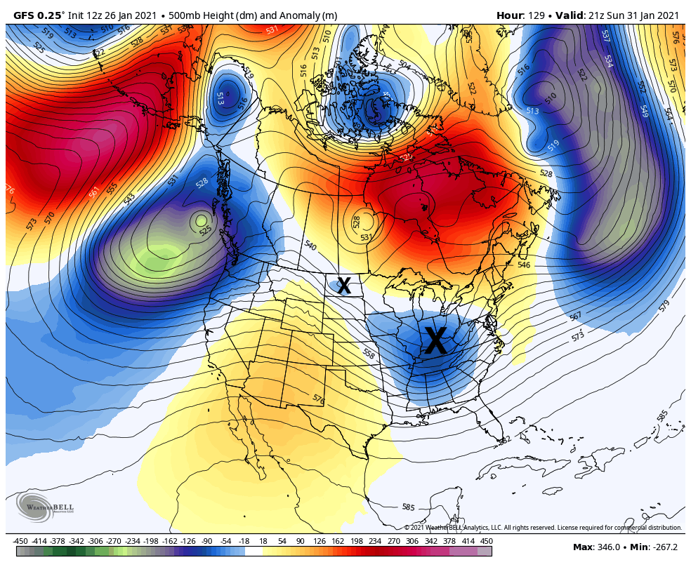
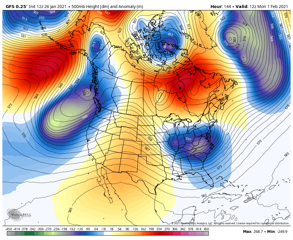
I already like the prospects of this weekend system much better than the current one. Let's compare 500mb. I'm using the GFS for now just to give the general picture. Currently: Gigantic trough in the west that drove up heights enough to send this dying 500 mb feature and surface low north of us while the sheared nature of the system split the WAA precip south and the precip with the primary low to the north yesterday. Our current event was an issue in the QPF department more than anything else. Just a run of the mill 0.5" QPF event up front would've likely given us a half decent thump of snow. Def a bust but this split was showing in guidance for a couple days on the lead up. Seeing any frozen precip at all is a testament to the blocking up top. We're likely 60ºF+ without it. So let's look at the GFS take on the weekend system, which has some mixing issues but a good bit of front end snowfall. 129hr: 144hr We finally get some ridging building in the western states and have an amplifying trough in the east. Ridge axis maybe a tad east of the ideal position but wavelengths are pretty short with this active pattern. This is a much better look for a strengthening system that can deliver decent precip. We also have a Canadian high being placed in a pretty good spot (didn't have much high support with the current system). You can see another shortwave carving the trough even deeper. Issue with the GFS was primary surface low tracking a little bit high and a late secondary takeover, but it still delivers a decent event. GEFS looks very supportive of the miller-B scenario and decent snows. Looking at the Canadian, the surface low track is about perfect for a PA snow event via a miller B evolution.. but not much precip and a very drawn out event. New Euro coming in is largely south of PA (starting to sneak into LSV at later hours) but is in the process of burying the Mid-Atlantic folks so far through hr 174, wow.


-
Half decent burst of snow currently. It's been generally a very fine grainy type snow most of the evening. Measured 0.4", which brings the day's total to 0.6" as I woke up first thing this morning to a light coating (0.2") to start the day. Maybe we'll graduate to measuring whole inches again this weekend.
-
@pasnownut That's what I was getting at with the first part of my post, you drive a trough in the west deep enough to snow in the Baja Peninsula your going to force heights up downstream. That's why we got this one cutting and its getting shredded in between the block and the attempted ridging in the east after peaking early and delivering a big snowstorm in the midwest. With regards to the cold that's been a concern of mine since late December and I've occasionally posted about it. I posted this over a week ago.
-
Totally lost it where?
-
It makes sense when you consider the trough in the western US that is of the magnitude of having it snowing in elevations all the way down in the Baja Peninsula of Mexico. You can fill in the blanks of what our weather regime would be like sans the -NAO/AO with something like that, though I'll go on a limb to say we probably wouldn't be discussing any prospect of winter weather for the upcoming week. The problem with today's system is it peaks in the midwest and is pretty much a sheared mess on our side of the country as it shoots from trough to trough underneath the blocking. We have sufficient cold although not ideal without much of a surface high. The QPF is the main problem as there has been a split between the WAA precip (which stays south and mainly southern tier) while the weakening low slides north and takes that precip mainly north of PA. This also trended away from a transferring to any kind of meaningful secondary the last few days and that also hurts with maintaining more of a solid precip area. Even with this being a mixing scenario there still would be a decent thump of snow if the precip's there for it. I mean we are still looking at some winter weather tonight even if it isn't much. This midweek storm unfortunately now looks to stay well south. This has a much more pronounced 500mb shortwave than today's storm but nothing to amp it. Closed 500mb low spinning under the block between here and Hudson Bay doesn't interact with it at all, and thus with the blocking pattern it's just going to shoot out. Is what it is. This current pattern is certainly doable for decent events here, that doesn't mean its going to work out though. Looks like we're going to be presented a similar situation to today later this coming weekend with something that attempts to cut, hopefully with more front end precip to work with and perhaps a secondary low.
-
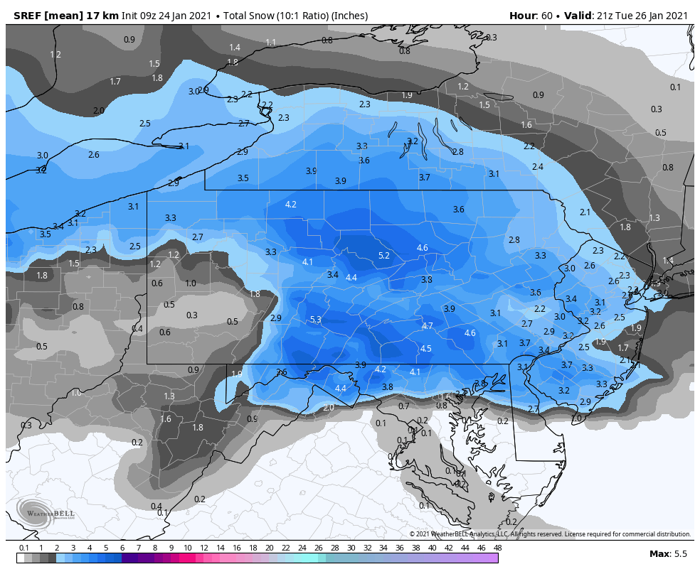
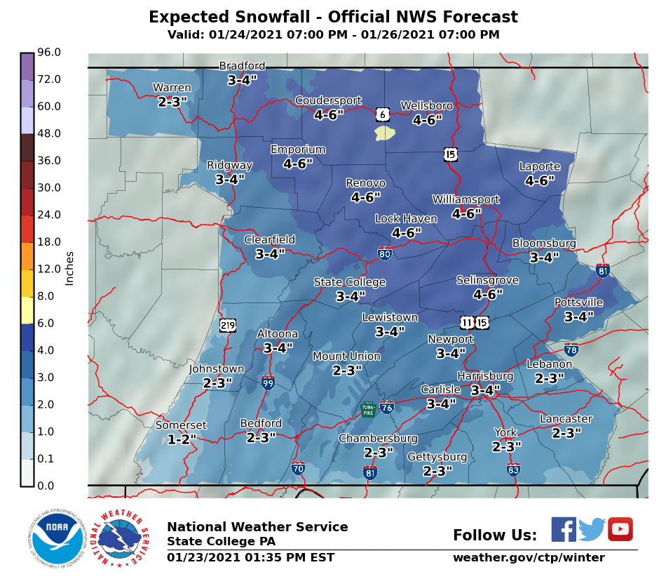
I don't often disagree with CTP on being too high on snow amounts but that's where I'm at today. Just don't think the 3-6" area is going to cover a majority of the CWA and almost all of the guidance is way more limited. We need the heavier precip up front to get anywhere near those numbers, otherwise this is looking like a T-2" with a messy mix for most with a narrow 3-5" swath somewhere. There seems to be a split between the heavier WAA precip (what we need for the front end snow) staying south and the precip with dying parent low staying somewhat north. The only thing that really supports what CTP has out and has a better push of the WAA precip into the area so for today is the NAM/SREF. It looks like CTP is going fairly close with the SREF with a bit less than that in the southern tier.

-
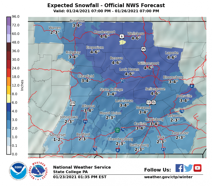
I don't think you'll see much mixing being up in the North Central. You may see a period of mix but the portion of the system where mixing may come into play doesn't appear to have much QPF. Looking at the climo stuff IPT is already at 28" for the season so far with 36.4" the 30 year average (38.8" avg since 1895). You score a decent event out of Mon-Tuesday and your essentially within a few inches of average for the whole winter before it's even February. Here's CTP's opening take:
-
QPF seems to be the underwhelming thing with alot of guidance today. We need some decent rates up front to get our shot at moderate snowfall before any mixing issues materialize, and well.. even if they don't. If you look closely at what the Euro did for instance, it doesn't even get much of the initial WAA precip north of the mason-dixon line despite tracking the low similarly to the GFS (Euro a tad weaker) . The result being is it actually thumps the DC and north folks in MD with a few inches. We have to nail placement of that down, as theres def some differences there between models. The NAM shows the best QPF and northern surge of the WAA precip. Gut feeling is we probably do get the WAA precip surge more up our way but we're dealing with a fading system here thats peaking out in the plains/midwest, not a strengthening one. I was initially thinking a narrow stripe of 5-8" warning snow for some portion of the subforum but this is looking more like a higher end advisory snowfall/ice combo imbedded in an areawide advisory for up to a couple inches, some sleet and perhaps a glaze of ZR. For the mid-week system, we have a much more pronounced shortwave with that one. Frankly, I'm not really sweating it being generally south of our region on most non GFS guidance right now. Our bigger ticket items this winter have all spent time south of us in the mid range. Heck this Mon/Tues system was being suppressed in the mid/longer range. I think the snow axis will be centered south of the December snowstorm and probably finally gets DC a half decent snowfall but I'm not convinced this mostly avoids C-PA... not with the mean western trough and some semblance of SE ridging building back in between Mon-Tuesday's event and this one. GFS 500mb presentation isn't that much different from the Euro with the exception that GFS might be a bit stronger/sharper with the shortwave. If I'm wrong and it misses south than so be it but I do think puts a swath across a more sizable portion of PA. It's a fascinating pattern for sure looking at the big picture of things and not the IMBY perspective where some haven't really seen much action. You have of course the base La Nina state trying to counteract with a Nino-esque active southern stream and significant NAO/AO blocking. Can't emphasize enough how much the NAO/AO showing up in a big way this winter has salvaged what probably could have been a warmer version of last winter to this point. With the current alignment in the Pac/western US right now, we're not even in the game without it.
-
I'd like to see models back down a bit on the primary track, as they've been creeping up toward entering the primary into western PA. Like I mentioned before, the blocking pattern forces the secondary development SE of the the primary off the Mid-Atlantic.. creating an alignment that could somewhat favor the Sus Valley between I-80 and the turnpike holding frozen longer than that same zone in the central counties. Either way, there would likely be more widespread mixing with the GFS primary low track. Plus it lags a bit in getting a secondary going. North central is starting to look like the place to be for an all snow event. I still favor primarily frozen p-types (snow/sleet) east of the Laurels though. We'll have to watch the Laurels and LSV below the turnpike for some ZR as well. If models edge back south a bit this weekend, preferably keeping the primary tracking just below the mason-dixon when transfer occurs.. this probably becomes a mostly snow event for most of the subforum. I'm also eager to see how the NAM and other short range guidance handle the thermals once it gets firmly in range later this weekend.
-
I'm mostly taking these systems one at a time. I see the next one later next week which has been showing on the models fairly well (in the sense of there being a decent storm being progged). Likely to be something, but we're at day 7. Like I mentioned before, par for the course that models are going to be all over the place handling the really blocky pattern we have. We're on the cusp of way too early NAM range with our nearest threat, and as such the models are finally beginning to hone in some. A full or nearly full suppressed solution for us is a very unlikely scenario at this point IMO. This is likely to be a decent winter storm for at least a sizable portion of the subforum. The primary issues I see right now are the extent of p-type issues southern third of so of PA and QPF/northern extent once above I-80. I think we're chasing a somewhat narrow axis of heavier snow but I also think our region is well situated for it. The setup isn't necessarily complicated. We're ejecting out a shortwave out of the very deep western trough thats going to get the squeeze play between that and the blocking/confluent pattern to our north/northeast as it gets sheared and elongated eastward. I think the western trough is a detriment to the Mid-Atl region in this setup. It allows enough heights ahead of the system to track it across a bit higher than you'd want to see it for that region. Additionally, there isn't much of surface high pressure present where you need it up over New England to really drive a CAD wedge deep into the Mid-Atl. Otherwise, if we had this non phasing system with a western ridge paired with this strong NAO (-2 to -3 magnitude), I have a feeling we'd be watching this pass us by well to our south. And conversely, you'd have your AC on if we didn't have the blocking to counter that really strong western trough. At any rate, handoff to a secondary low off the Mid-Atlantic coast looks pretty solid, so track/strength of the primary surface low is going to determine how much mixing along with the placement of the snow axis. Currently looking at the 0z GFS, surface low is a tad stronger and further north than 18z. With the flat trajectory of this system since it's getting forced east and reforming off the coast, this looks to be one of those setups where eastern PA may in fact be in a better place to stay mostly frozen even if the primary knocks on the door on the PA/OH border. I'm not really seeing surface and 925mb cold getting moved much at all. The 850mb push isn't very strong either and it's brief. There may be mixing issues, but north of the Mason Dixon it's likely to be mainly sleet if there is. Only SW PA really looks to see any notable liquid (mostly ZR on models). Once we get solidified on the track a bit better, we'll have to see how thermals are on short range guidance later this weekend.
-
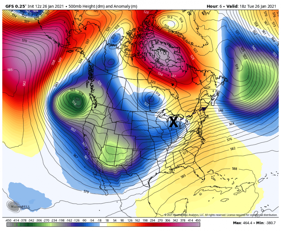
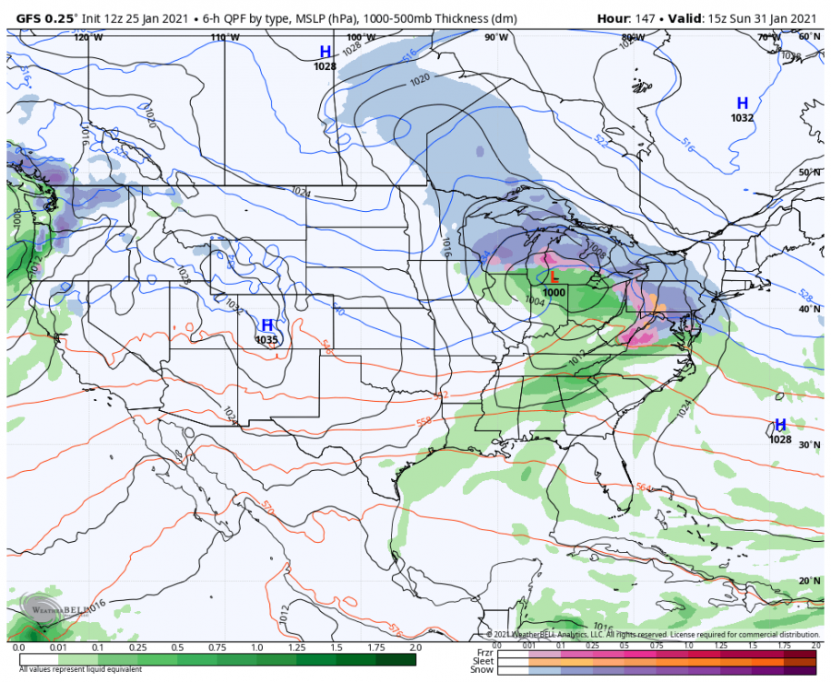
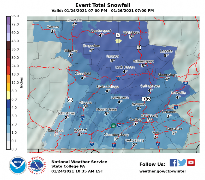
The primary low with that is associated with that comes up the Ohio River towards western PA and the pattern alignment forces the secondary southeast off the Carolina coast and then eastward away from the coast. You can see how the 500mb low arcs from CO to WI, then gets blocked and forced down through PA and then southeast off the Carolina coast where the coastal storm eventually deepens rapidly. Not a suppressed pattern in the sense that the US is overwhelmed with cold air. At any rate, gotta dispatch these threats one at a time though. This one slated for Monday/Tues is getting close to the short range and it wasn't a slouch on the GFS either with a 10+ bullseye in SC PA.
-
An actual legit clear and cold night here tonight with a bit of snow on the ground. 16ºF currently, probably coldest night of the winter so far.
-
Was that in Houtzdale again?
-
The December event was a bit more straight-forward and there wasn't an established strong blocking yet at that point. This is par for the course with models trying to handle strong blocking and confluence. With regards to the next event, with that deep trough in the west I don't think the storm is going to get stuffed south. The wave coming out is going to be shooting from the trough in the west under the block toward the other trough off the East Coast and how much the heights build in between is going to be important. Look at the rest of the model suite today, we're back to an attempt at cutting and wintry mix in both the Euro and Canadian. Canadian forces a secondary before the primary really gets above our latitude but Euro takes the primary to Cleveland with a secondary. Mid level features (850/700mb) are just a bit too far NW this go around on these models, we have to keep them just under us to get us a primarily frozen event (snow, perhaps some sleet). We continue to alternate these solutions, good thing there's a lot of time yet.
-
This shortwave passage has been pretty decent overnight here, just measured 1.6" and still working some bands of snow showers. 31ºF
-
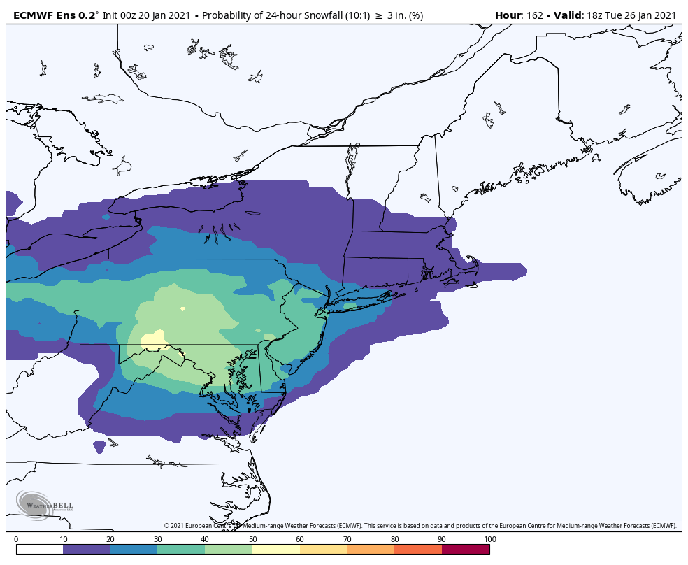
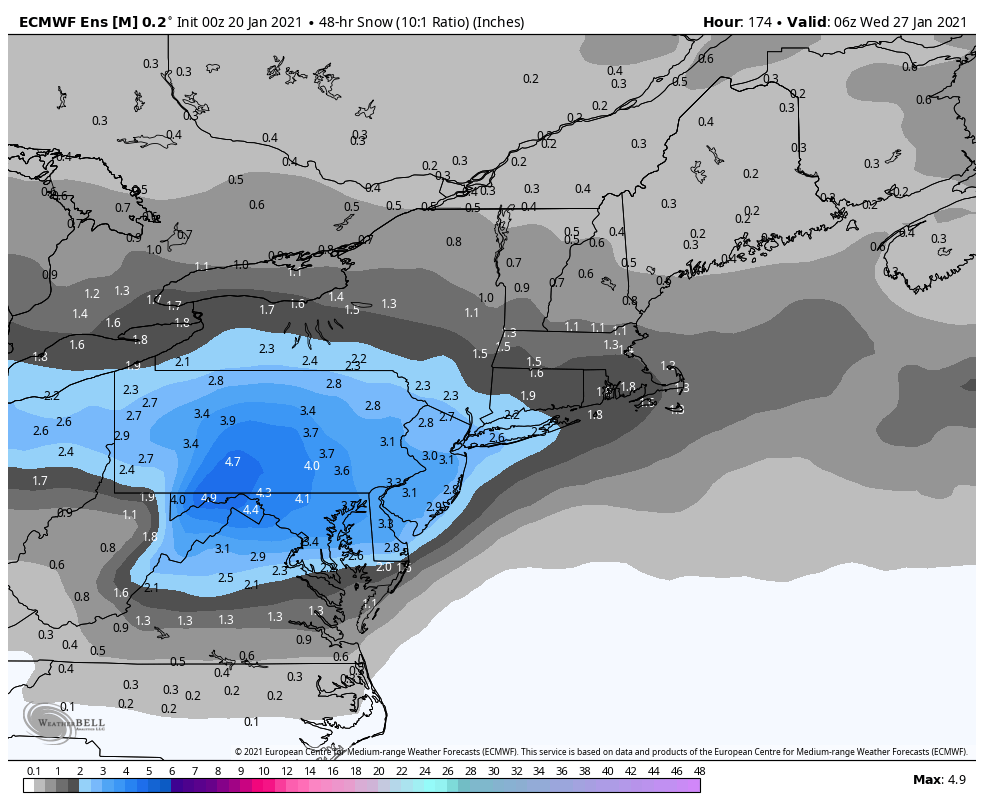
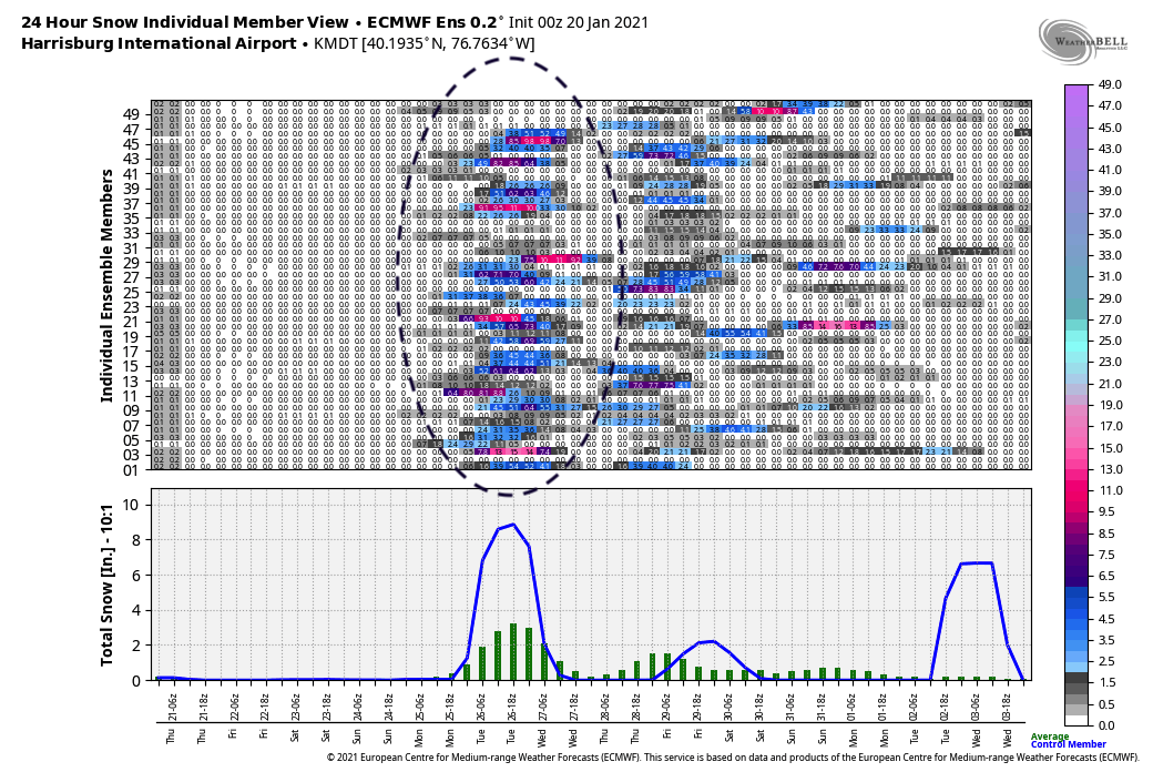
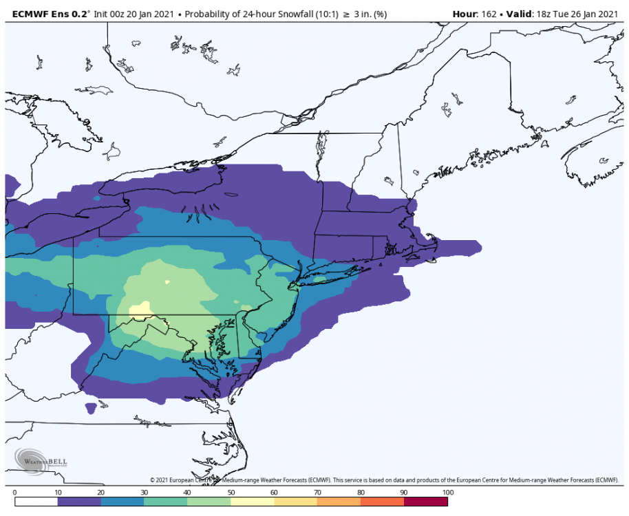
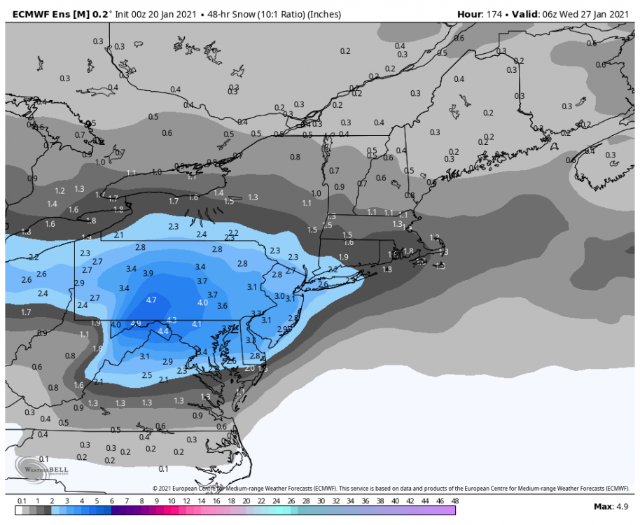
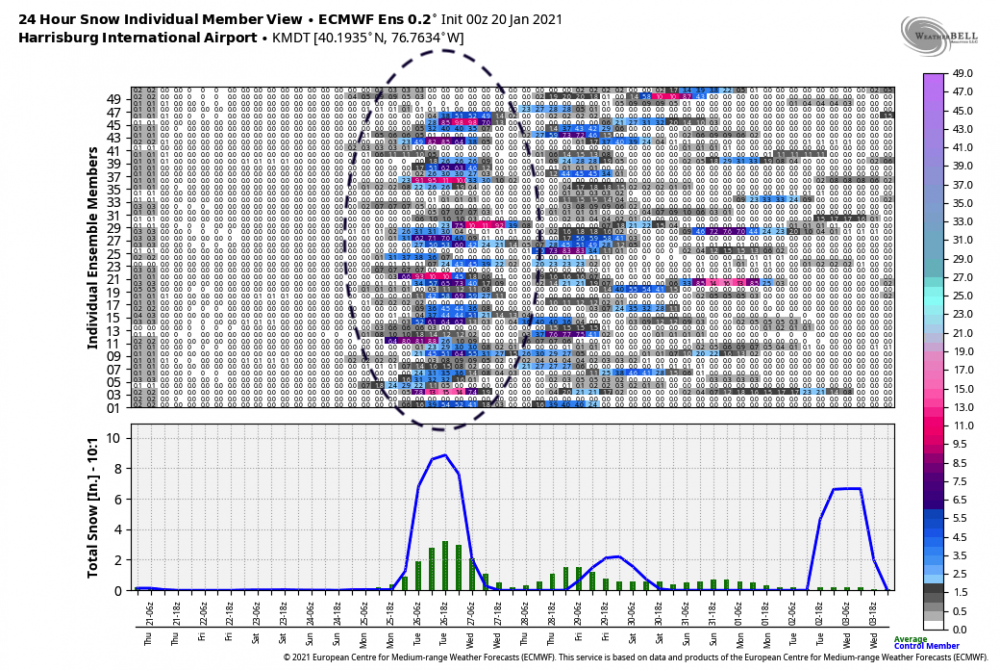
The 0z Euro was a heartbreaker tonight, skirting the southern tier with decent snow while having a major cutoff and a majority of the subforum area mostly dry (Mid-Atl storm). However Euro ensemble mean and control run looked much better for us and got most into some snows. Looked similar to the Canadian maybe a bit further north with extent. GFS and its ensembles are now on their own currently with cutting as far north as it does making for a mix. Meanwhile it looks like the Euro ensemble is solidifying a nice mean with a majority of members showing decent snows at most of our local stations now. Track is key, because if this does go south and not pull off what the GFS is trying to do, we're probably going to have to contend with a sharp cutoff on the northern extent of the precip somewhere. Harrisburg:
-
CTP mentioned in their morning discussion today they were concerned about some scattered snow showers/squalls making it into the Sus Valley with a potent shortwave passage later tonight into tomorrow morning.
-
Boy it's quiet in here for what looked like a half decent 12z suite today. Models seem to be showing more muscle with the blocking and could be two different events as well. Starting to look like more of a tighter situation of getting somewhere in between too much block (suppressed) vs bringing the low up enough to force mixing before the blocking sends it east or even ESE. The most mixy of the bunch which was the GFS today still had a majority of the region having a sizable part of the storm as snow as the block forces the low under and changes the initial ice to snow as deeper cold gets drawn south. Then had a decent snow event regionwide with the following wave.
-
Def a change from 0z lol. Comes out in weaker pieces, and way more confluence NE. That solution has 3 possible separate events between D7-D10.
-
So far 12z guidance looks better today for the system, GFS is more of a classic coast to coast out the latitude it came in type system.. which would generally keep it just underneath PA. Canadian actually squashed it under us completely with another shortwave trying to approach at 240. It had much stronger blocking above us (too strong in this instance). Gonna be quite changeable given the range yet and models trying to handle the block. I should clarify that I do think this system is going to be a winter event for us, but whether we can get a mostly snow event is the challenge as this has so far shown a pretty icy look. Whatever comes out is going to get deflected by that block, how much it cuts before it does so is the question.
-
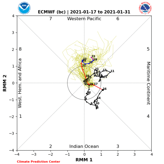
Had 0.8" overnight, mainly between 10-2am or so. I'm sure that'll be gone by lunchtime like Sat night's measured 0.9" snowfall was yesterday. Overnight guidance was meh on our potential longer range event. All the ops have the deeper system now which cuts. 0 and 6z GFS and 0z Euro have primary lakes cutters while Canadian tried to cut but forced a secondary (still a mix event). Ensemble guidance seems to look like it does something similar to the Canadian where front part of the storm cuts but secondary low takes over under PA. These are all mix event scenarios right now. This could trend colder to a more frozen event as it gets closer even if guidance still cuts the low, but I'm pessimistic on holding deep enough cold air for long for the reasons I discussed yesterday unless we force a secondary early enough. Longer range pattern just has not looked good on guidance to me. Moving the Pac ridge all the way to the Aleutians or even west of that and dumping a trough into the western US (also gone in the progs is the more sustained -EPO/-WPO) is going to screw up what was looking like a really good period if it comes to fruition..especially so if the -NAO relaxes but it's going to affect it either way when it comes to the storm track and cold air. Of course the longer range is highly changeable, but I am somewhat concerned this change in things may be right. MJO has quietly tracked into a low amplitude phase 4, looking like it may be arcing for a 4-5 run instead of being in the null phase. It's notable because model guidance is completely whiffing on it right now. The MJO site updates once a day with 0z guidance, and today's isn't in yet, but look at yesterday. You can see the big separation between the plotted point and where the ensemble guidance starts it's spaghetti plot. This is like this on NCEP guidance too. Models could be starting to adjust to where the MJO actually is, which would actually support what guidance has the Pac eventually doing. I hate to be pessimistic after being really confident on a very good winter period coming up last part of the month, but just don't like how things have evolved the last few days.
-
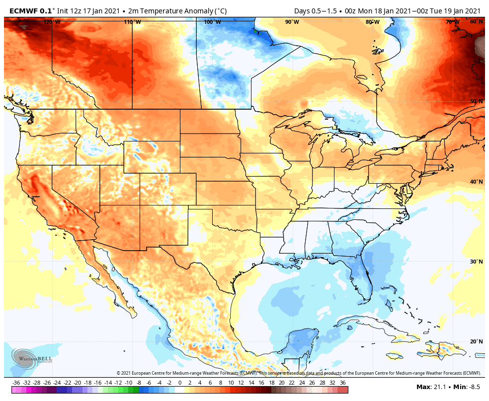
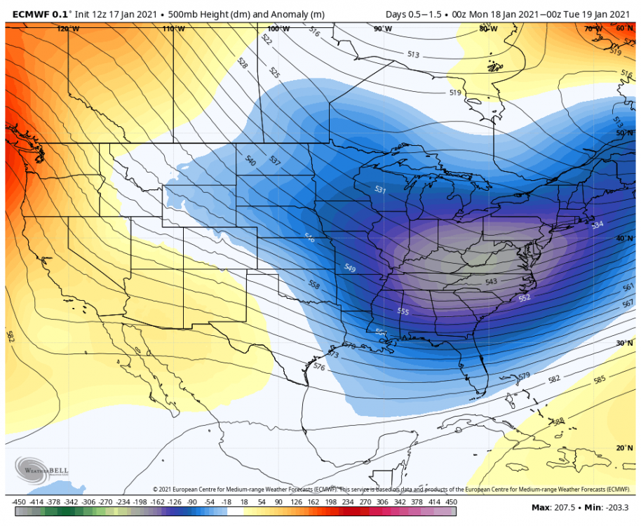
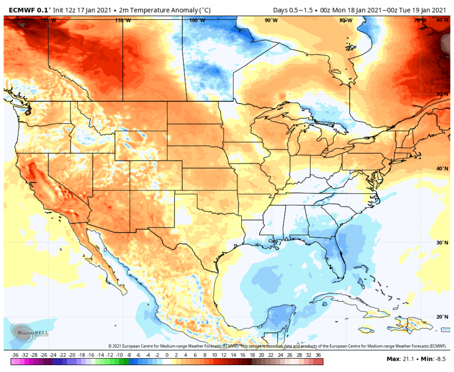
This system in the longer range slated for early next week seems to be solidly in all guidance now in the general sense. All the op guidance last night tried to cut it to some degree, making messy solutions. Todays 12z GFS was more of the same with the Euro and Canadian now having a colder/weaker solution that does slide south and is all snow. GFS's deeper solution has more amplification and some northern stream interaction while Euro/Canadian run a weaker shortwave wave out with no interaction. One would have to worry more about suppression with the latter given the blocking. Either way big differences in the afternoon suite. I've def been as optimistic as the next person with this upcoming pattern but i've soured a bit the last few days on some aspects. I'm not a fan of the evolution that has come about of retro-ing the pac ridge far enough west that it dumps the main trough into the western US (aka solid -PNA). Yea, with the strong NAO block the storm track will generally try to stay under us but I see limited phasing/amplification opportunity and if you do get it lined up/amped enough to get something like the stronger solutions from last night or today's GFS, they will try to cut. That brings me to the next problem, temps. Now if this potential system does try to cut into the block... it's likely going to weaken and/or transfer, and normally i'd favor a mostly frozen outcome even if the primary did get west of us. Problem is we currently don't have an actual solid cold air connection, and if that main trough dumps into the western US right when we finally see negative anomalies with some teeth building in Canada.. we're not going to be much colder than we are now as a lot of that cold will dump into the trough. So my worry with even the scenario of a stronger system with miller B evolution is we don't have strong enough antecedent cold to stave off a messy wintry mix type event over what normally could be a mainly snow event. Obviously a weaker system like the 12z Euro/Canadian wouldn't have the precip issues as we maintain colder temps, but the weaker system would be more apt to get outmuscled by the -NAO and only give us a lighter event or even a southern or suppressed one. Climo's on our side this time of the year with seasonable or marginal temps but we're going to get bit if we don't get some legit arctic air involved in the pattern. That goes double for the Mid-Atlantic region and the southern fringes of our region that can pretty much be an extension of the northern Mid-Atlantic climo. Current case in point... despite passage of a pretty deep trough where at 12z tomorrow morning there's sub 528 heights and sub 522 thicknesses across most of the state in mid-January, we're still going to be above average temp wise. That's something that normally could equate to a day that has highs in the teens to 20s-30ish NW to SE across the state with a run of the mill cold airmass. Harrisburg is forecast to still hit 41 tomorrow.
-
Heavy squall currently, getting everything whitened back up.
-
The two periods I have an eye on are D5-6 and D9-10 range. There's also going to be some weak shortwaves in the flow early this coming week but will likely primarily deliver periods of snow showers/light snow to the Laurel's and western PA. For the D5-6 (Thursday-ish) there's been some solutions that amp the northern branch just enough to generate a wave of precip to move across PA, esp on the Euro. This would probably be a light event if it occurred. Something's likely going to come out of this D10 range, but hard to say what at this point obviously. So far today the GFS and Canadian have something notable, but differ in the pattern somewhat. GFS dropped and phased a shortwave out of Canada making the huge storm it has. Canadian doesn't phase and also dumps the trough in the western US raising heights and making a more messy storm that tries to cut.