MAG5035
-
Posts
5,882 -
Joined
-
Last visited
Content Type
Profiles
Blogs
Forums
American Weather
Media Demo
Store
Gallery
Everything posted by MAG5035
-
It's the primary low. I've been saying over and over (and over) for the last couple days.. that low has to track close enough to put the precip shield over PA and transfer to pivot it over PA. The Euro had been ducking it and popping the coastal, narrowing the heavy snow swath. It's starting to finally put the precip shield from the primary solidly into PA like the GFS has been doing while transferring in time to keep things mostly snow.
-
The 12z Euro doesn't stall the low over Delmarva like the 0z did, does so farther east. The biggest thing I'm seeing is it's finally starting to fill in the precip shield related to the primary low. And trajectory of that and the handoff is good to hang the shield over PA. The western PA gang will like this run, it keeps Pittsburgh mostly or all snow. We have to remember this storm is coming on a straight west-east trajectory, not directly up from the Gulf. Typically, storms that slam Chicago with a foot plus of snow are ones that are cutting and giving us rain or p-type issues. Not with this block though. This is still a great run for a big snowfall, pretty much everyone gets a warning snow and Sus Valley still gets clobbered. The big thing with this setup is where the coastal low stalls, if it's east or it doesn't stall for long we see this result. If it stalls over the Delmarva like last night's 0z run did, then the excessive totals become more in play (the 18-24+ type stuff).
-
It's all good, just trying to keep comparisons straight. A lot of times shared info from the Mid-Atlantic thread is stuff that's being analyzed through the Mid-Atlantic lense. Here's GEFS means 12z vs 0z, ramped up pretty good in our region and some of the northern MD folks. 6z means are fairly close to 12z. Again, starting to focus more than shift.. imo.
-
Compared to what, the 0z run? 12z looks better in central PA probs wise. I see some solidifying of better probs but not a significant shift. Biggest difference I see is in western VA and eastern WV. 12z left, 0z right.
-
I haven't really been watching what the UKMET's been doing, I just looked at it today since it was commented on being way south. But yea lol, that's not an outcome I'm anticipating out of this.
-
Yea I know that's been a unofficial indicator of the Euro in the past. I recall the UKMET being south on the lead-up to December's storm, or at least that they weren't showing that connection. I'm sure there's a couple comments on it buried many pages ago in this thread somewhere since this thread started at the beginning of December.
-
Yea I'd say, it doesn't even snow in PA NE of Tamaqua on the UKMET. I also don't remember the UKMET - Euro connection being a thing with the December system.
-
GFS offers up a good representation of what I've been trying to explain about the handoff of the primary to the coastal. We gotta get into the thick of the initial precip wave of the primary, transfer the low and pivot the shield over us. If we do that, this is probably a really nice snowstorm for everyone in here. And even if it mixes southern tier, those folks are in the best position from the winding coastal low stalling. The Euro is starting to come around to this a bit better and the 0z last night was about perfect switching that primary 850mb low to the coast. It didn't dip the low as much. Euro ensembles at 6z this morning and 6z control run still seem to favor the southern tier and neighboring Mid-Atlantic and still seem weak with the precip shield in between the transfer.
-
Lol, I wasn't trying to imply anything in here since this is where we discuss such things. I just noticed that post came out right around when the GFS did.
-
This is timely, lol.
-
GFS barrels the primary 850mb low into PA creating enough of a southern push for the P-type issues before it reforms over the coastal and changes p-types back to snow. Nit picking where the random L's get plopped over the general surface low pressure area stalling off the coast aside, the placement of the precip shield is okay. And it's a long duration event like everything else has. The issue is thermals, and how it tracks the 850mb low... and looking back and comparing the whole last model cycle it's been really consistent with that. Suppose one could argue it thermally may be too warm if the deform precip has heavier consistent rates since 850/925 temps are somewhat marginal. But yea, GFS still in it's camp. The Euro has been arcing that 850mb low under us before it gets to PA and then reforming while the Canadian just barely gets it under us. Something's gonna give with this eventually.
-
That's basically the watered down explanation on what the GFS has been doing, so I'd guess he's heavily weighing that particular model into his forecast.
-
I feel pretty good about the prospects of a decent winter storm in most of central and southern PA. The primary track and how the handoff to the coastal shakes out is going to be a key on if/where this becomes an excessive snowfall event. If we get the front end WAA precip sent into PA like the GFS and we track the low where we keep most of PA snow and that transfer to the Delmarva occurs, this will be a really big snowstorm for a big portion of the subforum as you would position the pivot over our region. If it dips like the Euro (and to some degree the Euro Ens) has been doing and has the coastal more quickly take over, this is a moderate event with a tighter area of heavy snows probably focused southern third of PA and Mid-Atl. Unless the GFS starts changing it's tune, we have to respect that option too (some southern PA mixing). If we are to play some devil's advocate here, the GFS spent a couple days in the mid range being about the only model having yesterday's event do what it eventually did.. while the Euro was trying to bury it under us. This is a different setup though with a boatload more potential. I posted a couple pages back on the easterly 850 wind anomalies. The 12z Euro had monster anomalies and is def NESIS quality on guidance as a whole. December's storm had similar, although with the blocking in place this is probably going to be a longer duration coastal than that one. The pieces are there for this to be a big one. Who's going to get it is still up for grabs.
-
Think that would out jinx the Mid-Atlantic having the storm thread up for this? Haha
-
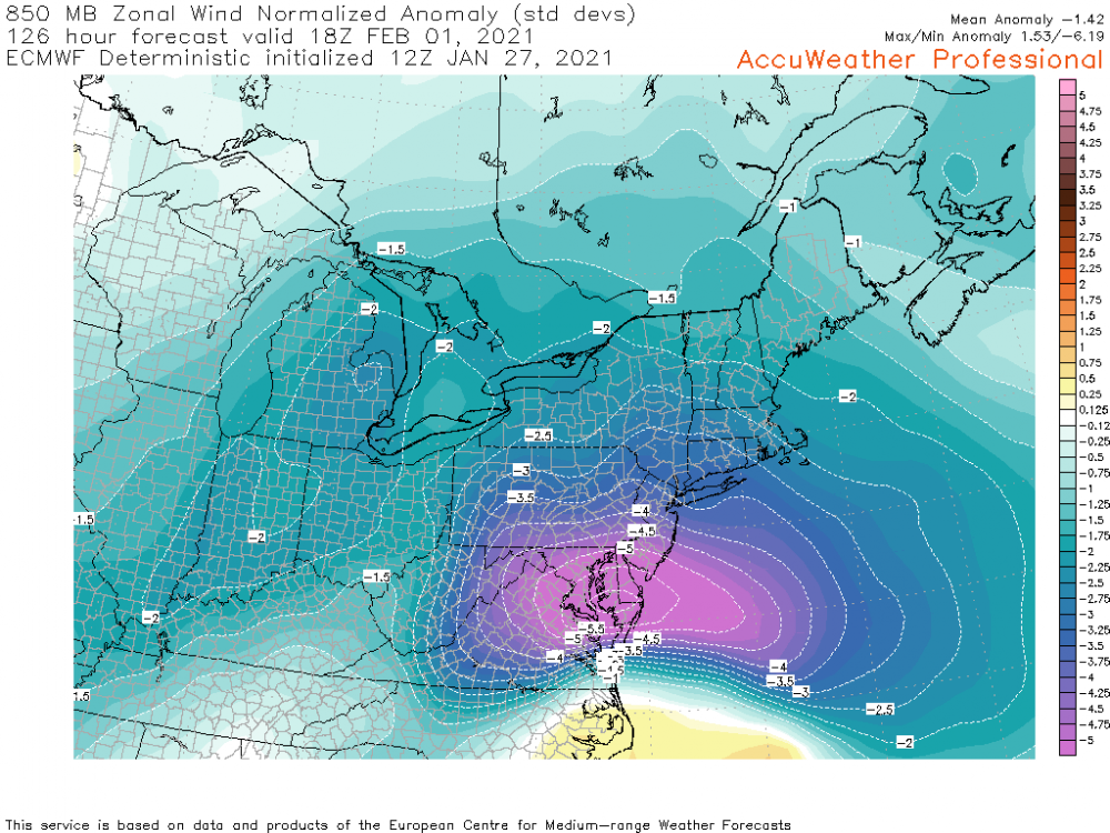
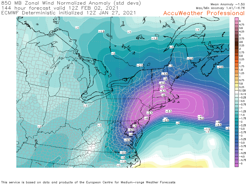
You guys should get excited when I put these particular maps out. -4 to greater than -6 standard deviation 850mb U-wind anomaly (40-60kt eastern jet) aiming into the Mid-Atlantic and eventually southern/eastern PA. One of my big storm benchmarks. This def makes me somewhat suspect of some of the lower QPF between the transferring lows. Hr 126 Hr 144
-
If the Euro didn't kill off the WAA precip from the primary low as fast as it's been doing we'd have a much more uniform swath of snow across the state. It's not that far off from what the Canadian has until the transfer. Euro's getting over to the coastal faster and the coastal starts off stronger further down the coast. They hang the low in pretty similar spots with the Euro stronger and a bit tighter to the coast. The overall storm scenario is still quite workable for everyone.
-
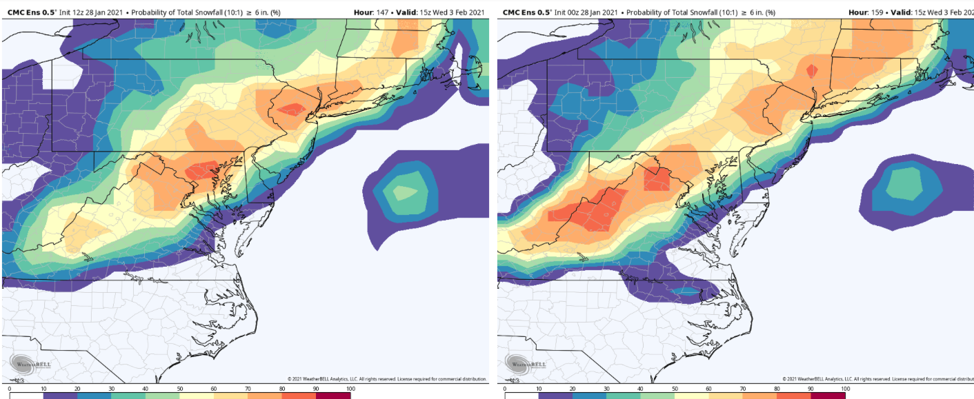
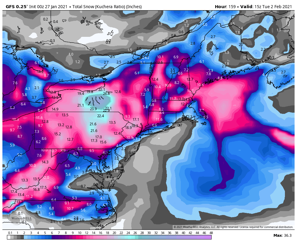
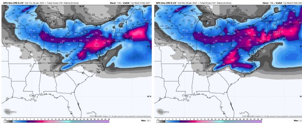
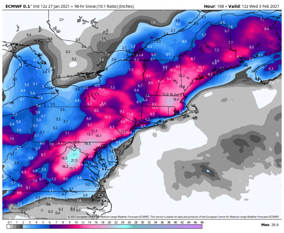
4-day snow totals to cover the whole event but separate out the Lake Effect in upstate NY early in the forecast period, so it's a 10:1 map. Kuchera totals generally look a couple inches higher. This is a big shift from the 0z op run and while not dropping a 40 burger on anyone it's a better overall coverage event than yesterdays 12z.
-
Yea the Canadian has been throwing out really great tracks to hold the precip shield right over PA and keep it mostly snow but has been somewhat dry on QPF. Like that's pretty much what we're looking for in terms of a Miller B track. Certainly the fetch via 850mb easterly wind anomalies could argue for sufficient moisture to support more robust QPF with the high up north and a long duration slow moving coastal.
-
I like how no one mentioned the 0z Euro op run overnight and this morning. That was def a way to lose the storm lol. The confluence to the NE is going to be another piece of this. Theres a pretty deep 500mb low passage that drops SE through New England over the weekend and gives us a glancing shot at some arctic air. It appears the Euro lags at clearing that feature out vs the GFS, which redirects the primary system southeast and really prevents that initial wave of precip getting into PA... depending mainly on the coastal development which with the pattern alignment likely would limit how much of the region saw significant snow. I know we all seem to be scared of Miller-B's in here but we're probably not going to see a widespread big snowstorm in the subforum with this setup unless the primary gets close enough to get PA into the good precip. Then ideally the transfer to the Delmarva will hang the precip shield over PA and the coastal does the rest. The slot doesn't come into play unless the primary and handoff comes in too high, and I don't really think it's going to happen here. For now, the Euro ensemble guidance seems like a decent compromise between the op trying to stuff the storm under us and the GFS/GEFS skirting that high line of mixing the southern tier.
-
GFS still mixed southern tier for a time but it's been creeping toward a less mixy solution since 12z today. It also tucks in the coastal low closer when it pretty much stalls, so overall it's looking pretty good.
-
Lol I was gonna say..
-
If this is no bueno I'd like to see whatever it takes to be muy bueno.

-
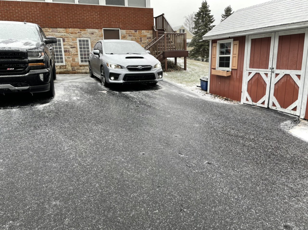
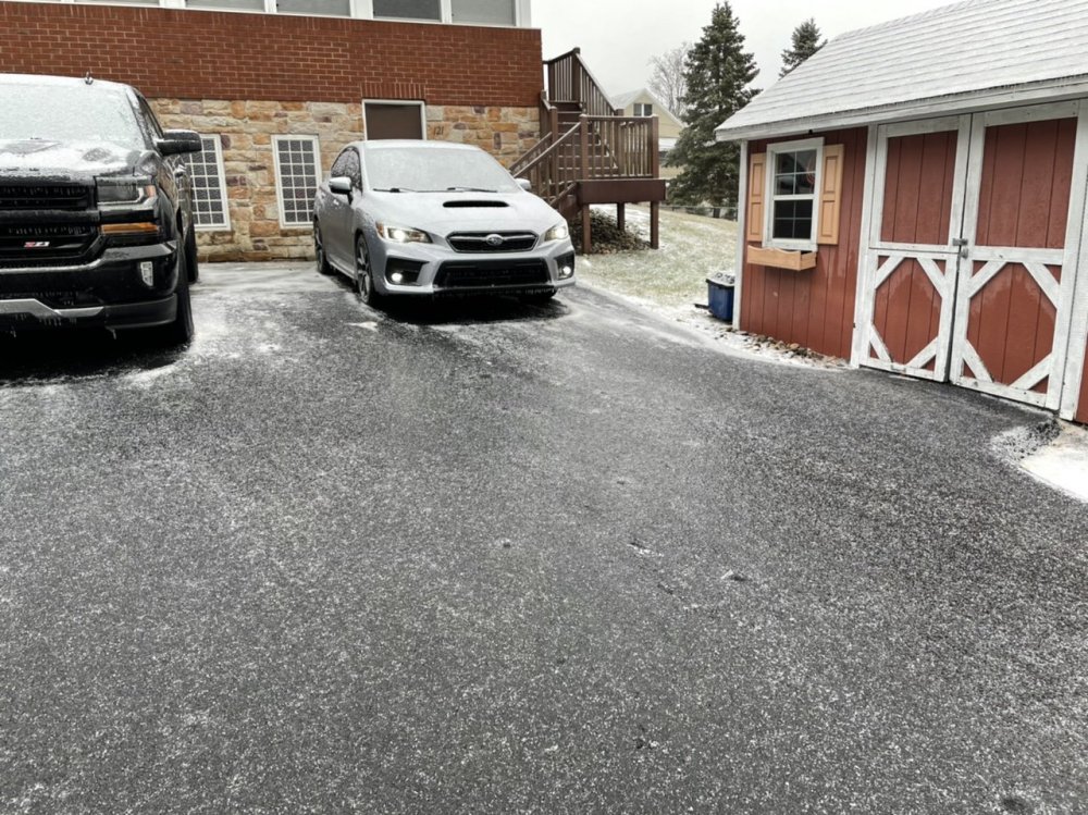
I haven’t been outside all day but I figured the driveway was just some slush to push off. Nope.. what a mess. Another winter day at the ice kingdom. Temps are still near freezing.
-
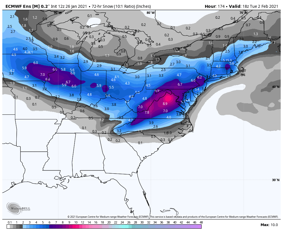
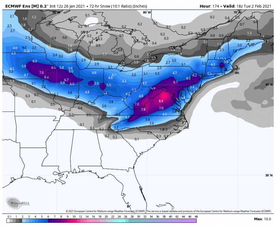
We gotta get the WAA precip with the primary to us and then get the transfer going, basically what the GFS does on the front end but get a transfer positioned like the Canadian. The Euro evolution drops it under us when it transfers to the secondary all the way in GA/SC. I mean yea it does catch the LSV below the turnpike pretty good in the end but I'm def not rooting for forum splitters. Early looks of the Euro ensemble looked good, there's several big PA hits in it. 3 day total snowfall:
-
Euro primary's on a trajectory notably south of the GFS and definitely slower. It gets secondary going all the way down in GA/SC that arcs up to VA Beach. Energy phases and it hangs the low right around there before fading out. The low's in an okay spot for us where it hangs but the way it get's there probably limits precip extent into our neck of the woods. The GFS isn't really that bad, it was pretty close but a bit late on the secondary and the primary comes across the country higher. Canadian tracks more similar to the Euro but like mentioned above the Euro has the secondary going the whole way from the SE while Canadian transfers a weaker low from the Oh Valley to the Delmarva. The Euro basically just put up the ideal way to bury DC/Northern VA with it's 12z op run.