MAG5035
-
Posts
5,882 -
Joined
-
Last visited
Content Type
Profiles
Blogs
Forums
American Weather
Media Demo
Store
Gallery
Everything posted by MAG5035
-
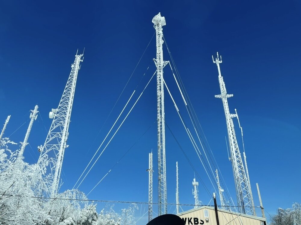
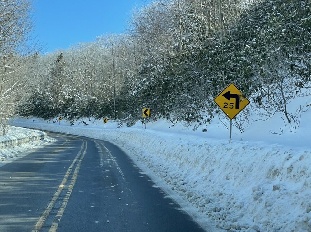
These popped up on my picture memories, what a difference a year makes haha. I took these a few miles up the road on this date last year. For today day though, there’s just a few piles around (the yard is completely clear) and the high here was 62ºF.
-
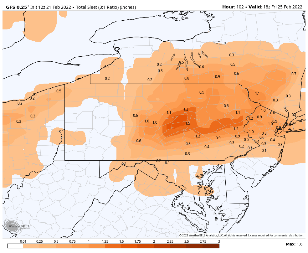
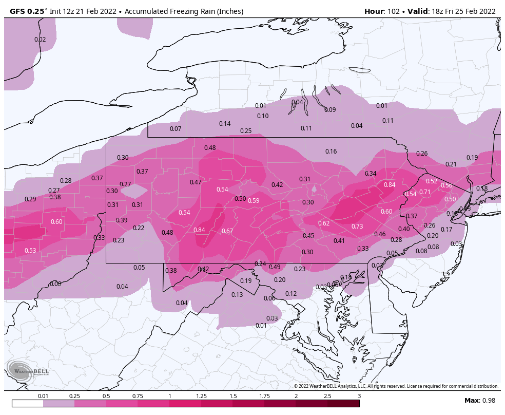
It’s actually showing more conditional freezing rain than sleet. Usual disclaimers apply, especially with the freezing rain map, but I certainly don’t think this is going to be a non-event for anyone in here. It’s definitely going to be messy up front. Main thing, again, is the GFS now dragging the low pressure into PA. It has to get under PA for more frozen (snow/sleet) vs sleet to ice/rain…simple as that. The early NAM take showed that two distinct wave look a lot of guidance has been showing, with the weaker first wave tracking a weak low south of PA and more frozen up front (and obviously out of range yet for the main wave). That two-pronged approach is a fairly common thing with these longer duration mix events and probably the best chance for any front end snow prior to the mid levels being too warm. Unless this goes back south.


-
Well I’m not super thrilled about it, but mainly because I am so tired of seeing the non-fringing systems being mixing events this winter. I do think this thing presents a better ice threat than the Feb 3-4 debacle. You have the system pressing an established high pressure to the north (which is stronger/better placed) instead of trying to draw the cold air in mid-late storm. There’s enough time between the Tuesday rainer and the Thur/Fri system to set the edge and establish good CAD. Also for the sun angle queens (I’m one of them in this case) the system comes in mainly overnight Thursday. That point is really only relevant for any ZR accrual potential. So overall I think the potential for the whole area to see at least see an advisory level mess is quite high. And as it looks currently, yea there’s probably a period of plain rain for the LSV (esp below the turnpike) somewhere late in the system. I don’t think plain rain is going to dominate this time though. The big question right now is dominant mix type (sleet vs freezing rain) and if we can see more frozen (snow/sleet). Models didn’t trend that way today and aren’t looking like they are with the 0z suite so far. Ensembles have mainly supported more mix, even the GEFS when the op had a more frozen solution. I Mentioned last night we need to get the surface low pretty well under PA. Given the strength of the high progged, it’s certainly doable, not to mentioned models have been showing some attempts at a coastal secondary low. Regardless, sneaking into PA isn’t going to cut it, so this needs to find a way to trend south for more significant snow/sleet in C-PA. A lot of guidance has kind of separated out an initial wave of precip prior to the main wave as well. It’s probably with that where snow can be scored unless we get said notable trends south the next couple days. I’m usually pretty bullish on the deeper CAD winning these scenarios, especially back in this area.. but the tendency this winter has seemed to be the opposite. We’ll see what happens. I want to get into mesoscale range to see what those models do with this.
-
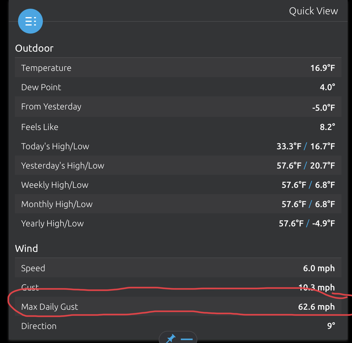
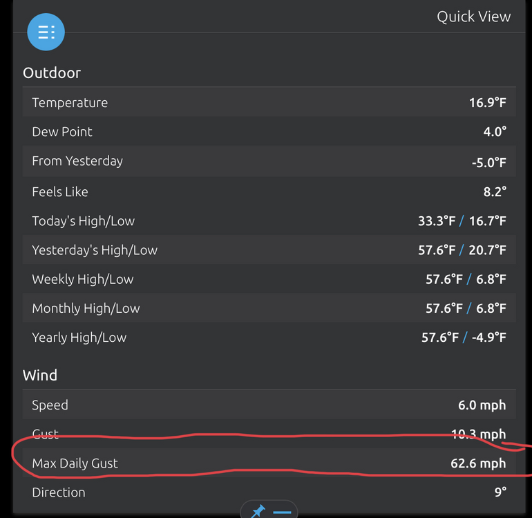
There actually weren’t too many issues damage wise, there were a couple power outages here and there but nothing in the neighborhood. I was trying to review the hard data, it data-logs on the console once a minute so it looks like the gust occurred in between minutes. It still notes the highest wind gust for the day. The highest that got logged for the data were a couple shots above 40. I’m sure there were probably more than that since the station itself reports wind back every 5 seconds. My guess is that big gust was probably a brief one off at the time of the afternoon that probably had the best mixing with diurnal heating while most other high gusts were in the 40-45 mph range. Otherwise there would have definitely been issues with frequent gusts say in the 55+ range. Still learning the station and how well it does. It seems to be pretty accurate overall. The rain gauge logged 0.90” total from the rain event Thur-Fri.
-
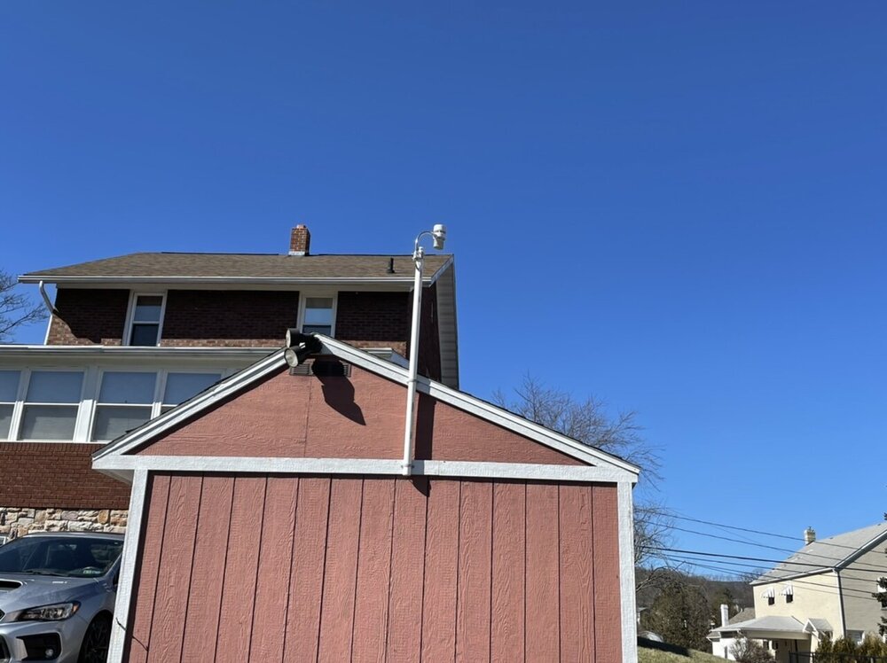
I installed an Ambient WS-5000 (the model with the sonic wind sensor) back on Jan 14th and I had been wondering how it was going to do with a decent wind event. I considered mounting it at the highest point of the house on my center chimney that’s not used anymore but decided to high mount it off the shed. This pic is looking in a NW direction so I was wondering if it was going to get shielded some by the house. I have a pretty open yard but there is a tree line on one side and houses so I felt this was the best compromise for positioning the station. The highest gust it recorded prior to yesterday was Friday’s wind advisory event which was like 39mph, which I thought was reasonable because I never really had advisory type winds here for that one. Yesterday though, it registered a 42mph wind gust during the snow squall passage and then later in the afternoon a sustained 40mph/63mph gust. So while the siting for wind isn’t completely ideal, it apparently is exposed enough to record bigger gusts. That and I guess I mounted it well enough to withstand at least 63mph winds haha.
-
The distance between big snow dump and heartbreak is about the same as the distance from Tamaqua to the lower end of Harrisburg lol. Although in the rest of the LSV where there’s not big snow it printed out 2-4” of sleet. I haven’t really gotten into this potential the last few days but it’s probably time I should start diving into it. Been waiting to see what it looks like more in the mid-range. Going back earlier this past week I really wasn’t sure there was going to be much favorable this coming week but I suppose the second half of this month is working out pretty close to how I laid it out back in my last longer pattern post back on the 7th (changeable but still a chance for opportunities). At any rate, I’m not getting too hung up on snow/ice maps for now with this threat later next week. Track of the low needs to stay pretty decently under PA to secure a more/mostly frozen outcome for the forum majority. Anything else is going to be a mess. I haven’t really commented much on the threat but I have been watching and I think the thing that sticks out to me is that the high being progged to the north IMO looks to be the best presentation I’ve seen for an event all winter so far (strong and well placed). So I think chances are pretty good that this is going to be some kind of a longer duration wintry event. All the other details regard p-type/amount are going to be a crapshoot as it always is.
-
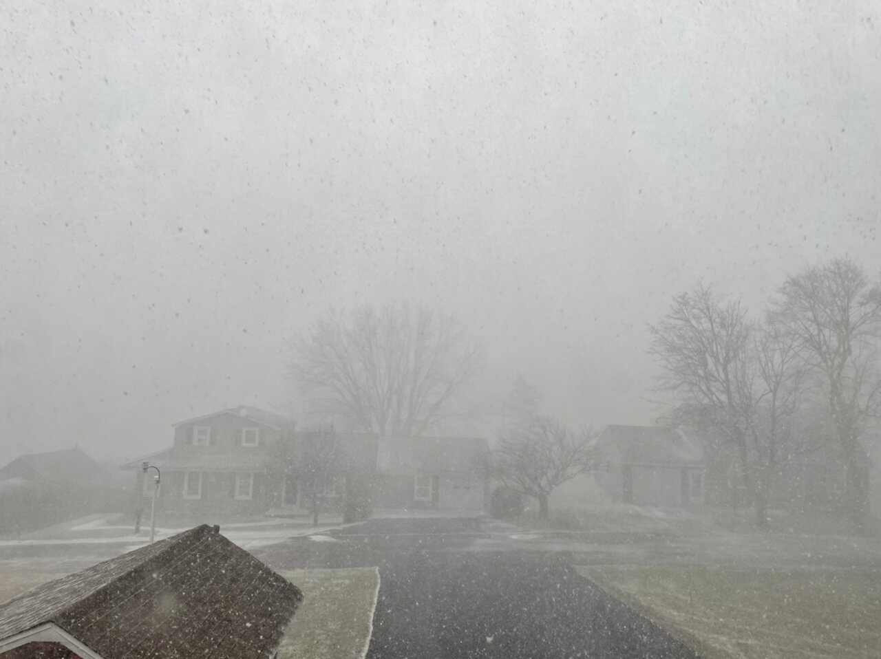
I had to leave for the day right after the snow squall ended this morning, which best estimate I could get was about an inch. This apparently happened at 336pm this afternoon and it came with a 40.3mph sustained. Attn: @canderson lol
-
It’s here, absolutely insane right now. There was a 41 mph wind gust after this pic.

-
I didn’t get the crazy winds tapped down back here with the frontal passage but I already have a wind driven snow blowing around outside and 33ºF. Temp has dropped almost 25 degrees in under 3 hours.
-
Front is going to be arriving here pretty directly. Very pronounced on radar, and that’s 70-90+ mph aloft on velocity immediately preceding too.
-
Yea I mean to be honest I was busy this afternoon and evening and didn’t even realize the wind advisory started so early at 6pm as I thought the wind was a more overnight thing. Winds are definitely screaming aloft which is evident on CCX velocity and on the time-lapse video I added on my previous post. The cold front is past Pittsburgh but still in western PA, so I’m going to reserve judgement on winds until i get the frontal passage here and just after.
-
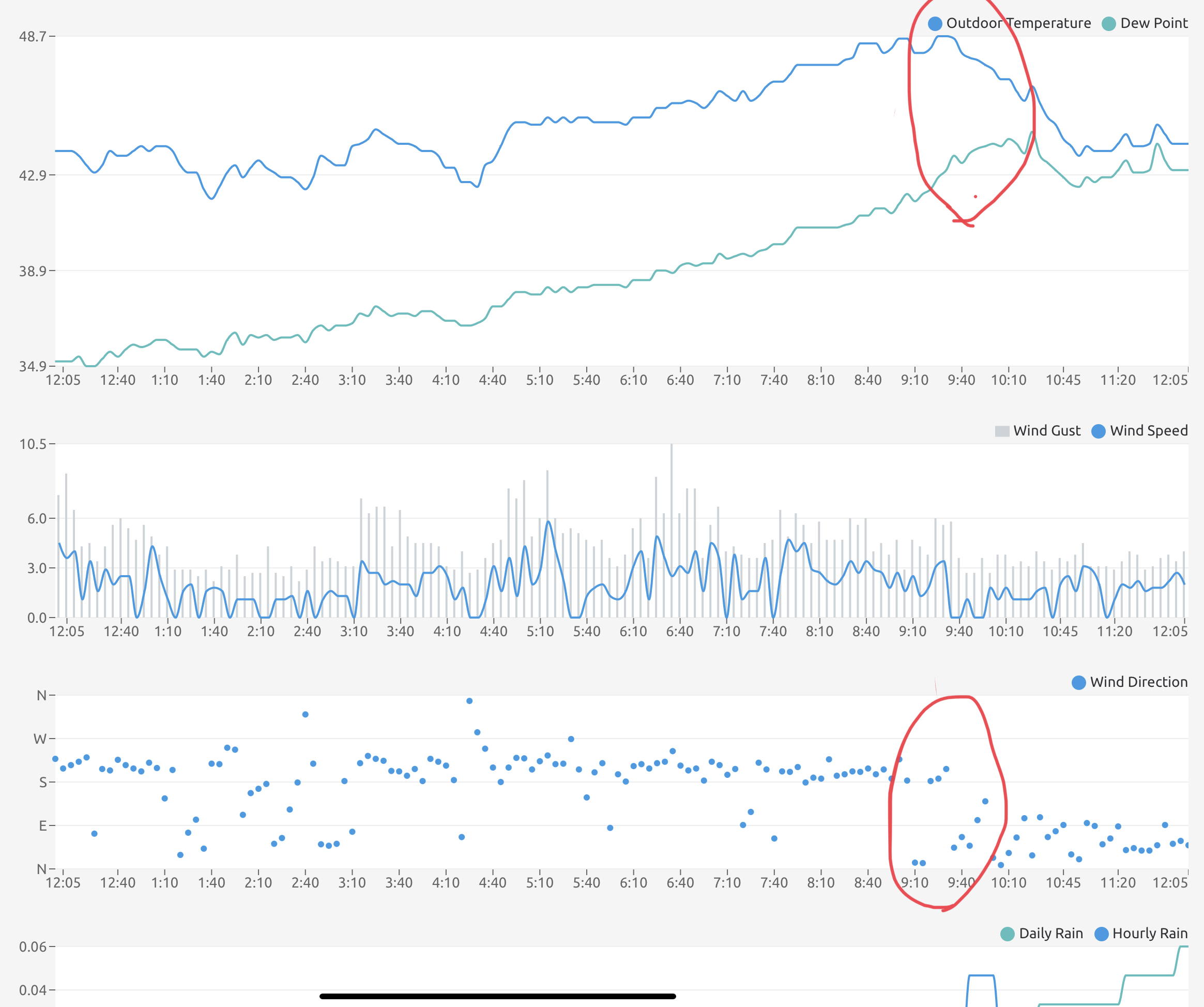
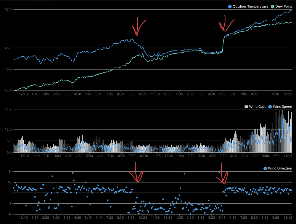
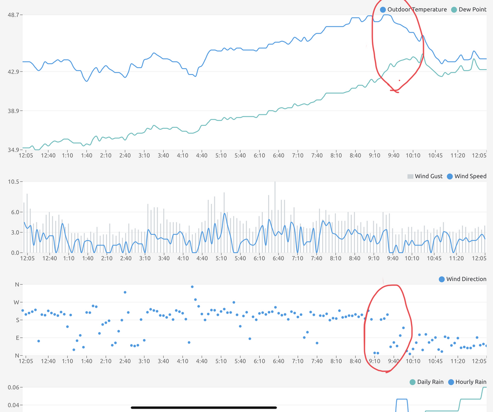
It has reached 57ºF with the winds starting to ramp up. KAOO is really ripping with the latest ob S 40mph G51mph. Nothin like that here yet, and station so far has a high gust of 24 mph. 0.78” is my rain total so far. Update from the earlier observation post, find the spot where the warm winds did finally mix down earlier this evening. Here’s a roughly 1 min or so time lapse of the clouds screaming by. IMG_3985.MOV
-
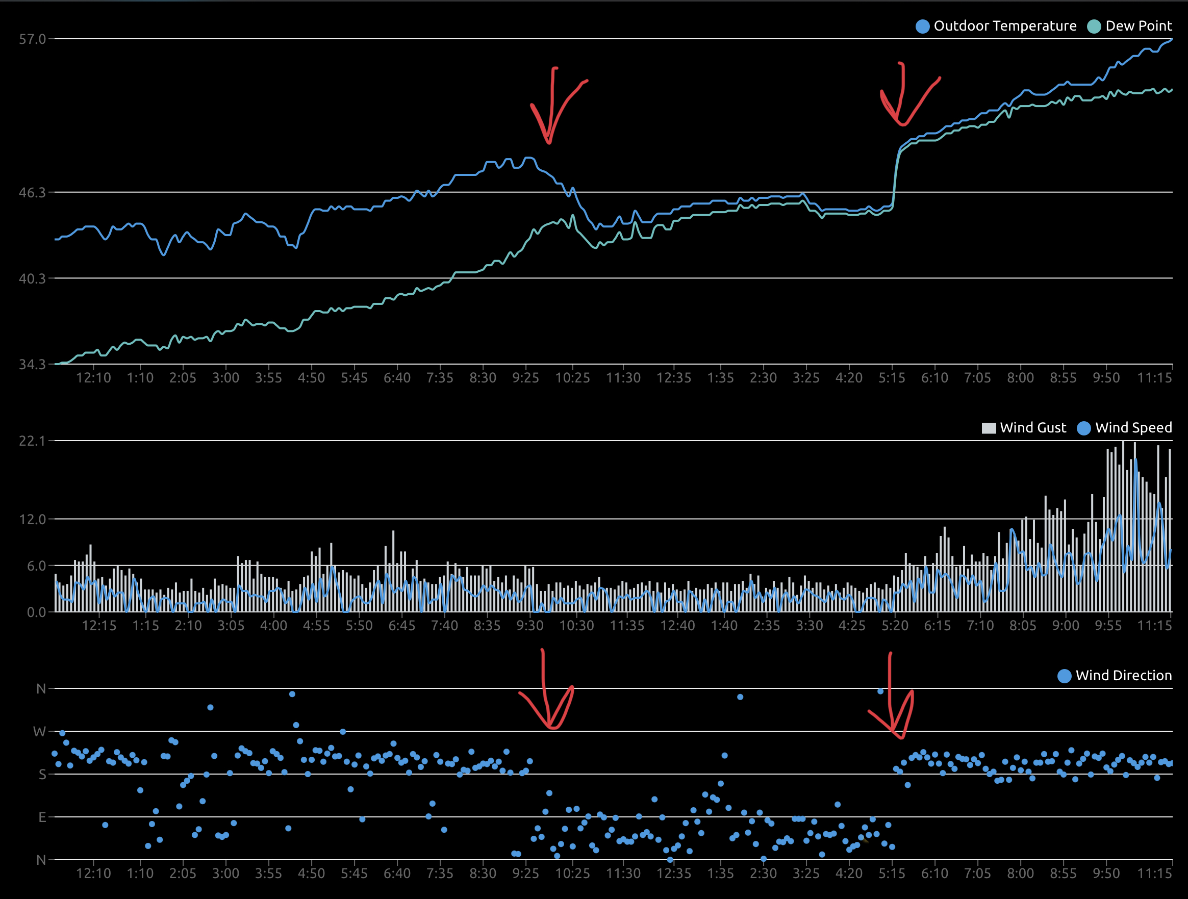
So far it is only 44ºF here currently, after being near 50ºF prior to initial precip arrival this morning. Obs show a wind shift at the temp drop. Classic trick here in this valley, bleeding cool air from the north/northeast under a stable boundary layer. Probably won’t see the big temp spike until the stronger southerly winds mix down.
-
Yea ground could be part of it to a degree. I do think the combo of the solar and the LSV temps (a degree or two either side of freezing this afternoon) is the main culprit with the light fluffy snow. Guess we can call it a combo of all three. If temps were about 5-10 degrees colder I don’t think the snow would be disappearing as easy. Solar is getting into that part of February where it becomes a good bit more noticeable going into the second half of the month but it’s not going to do much to an established pack if temps are cold. I hope so, missing these events going east is getting old.. although I did overachieve with my T last night haha.
-
@canderson is going to be mulching the garden today after all lol.
-
Light snow here currently, which is already more than I was expecting to see from this. 29ºF
-
Still some pretty big differences with the 3k vs 12k NAM, given upstream radar trends at PIT,RLX (Charleston), and JKL (Jackson, KY) I’d say the more filled in presentation of the 3k is more on track. I wonder if the GFS is going to ever see this event before it starts in the LSV.
-
Nah not really, the warm day yesterday relegated it to being pretty patchy. The only area nearby that likely has any solid pack left is the higher elevations in the Laurels. Despite holding on to a half decent pack for about a month or so, our snow averages back here aren’t much better than the LSV percentage wise. I consider a winter in the 45-55” range to be average in this specific location.. I’m just under 20” at the moment. In the Laurel’s, Blue Knob Ski Resort has noted a season to date total of about 44”, while Seven Springs has 54”. Laurel Summit’s (near the 7 Springs Resort) average is over 150” and Blue Knob is in the same ballpark with it’s seasonal average.
-
Nah I’m just joking haha
-
Between all the Sixers talk and the talk about daffodils and getting the garden going the last couple days I was wondering if I was still in central PA lol.
-
High was 52ºF after a low of 16ºF this morning, so quite the diurnal range of temps (+36º). Also pretty dry with dewpoints mostly in the mid 20s this afternoon, so not a complete meltdown…but open areas did melt off pretty good today. Yea at this point I just want a straight-up 5-10” snowstorm with no baggage (mixing), preferably this month. I haven’t looked super hard past the next couple weeks but I feel like if we have a total pattern change and more extended warm spell towards the end of the month, we’re likely to have another potential cold/wintry period sometime in March probably about the time when everyone starts really getting spring fling in here.
-
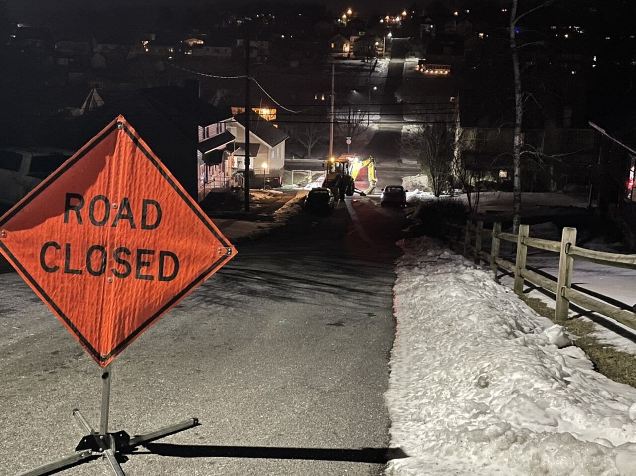
Currently 17ºF/15ºF outside. This is the current situation just down the street… another busted water line. Fortunately my water comes from the other way. That’s the 3rd one I’ve come across around the city in the last 5 nights. This cold stretch has done a number on that and the roads (bulges, pot holes, etc).

-
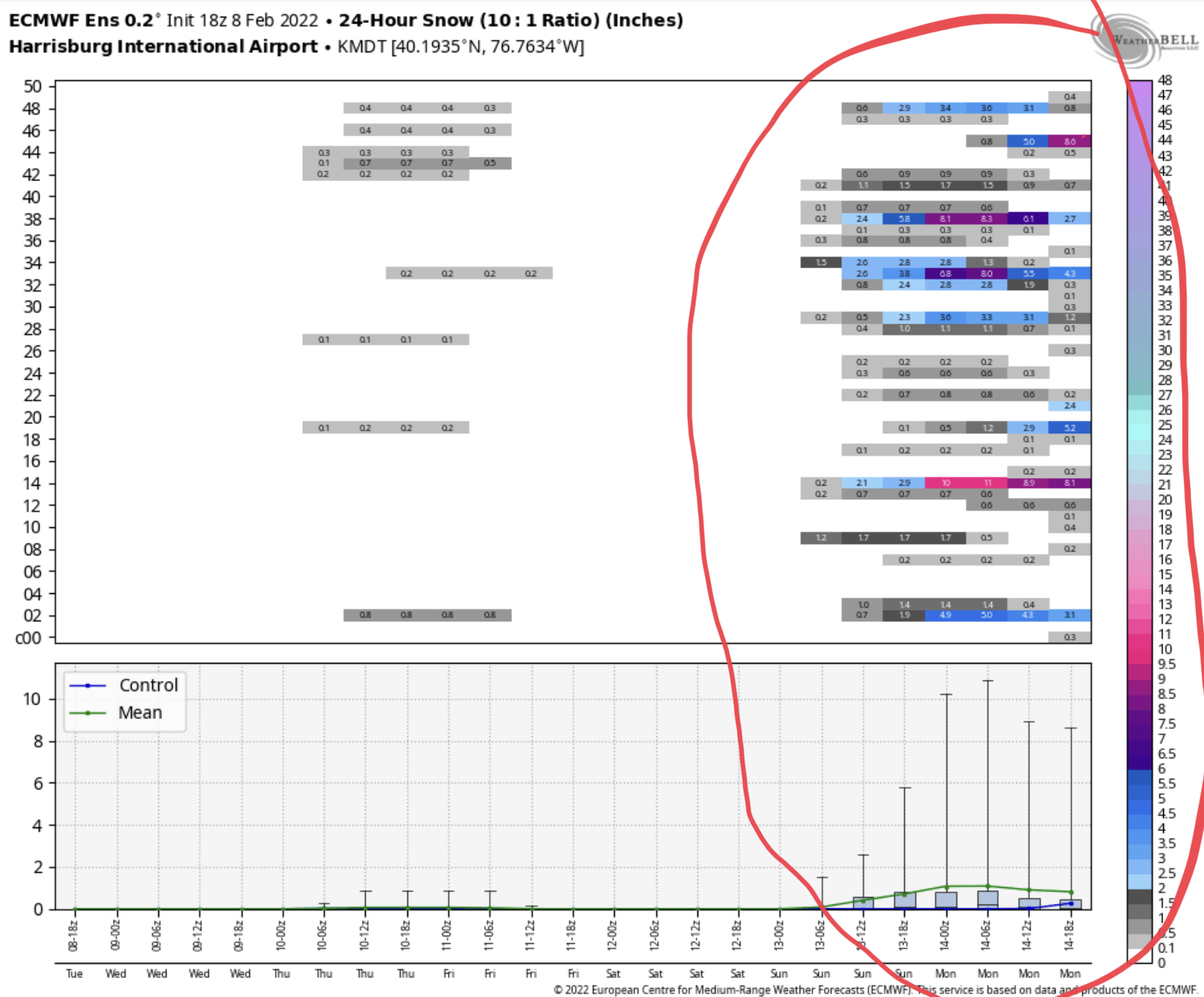
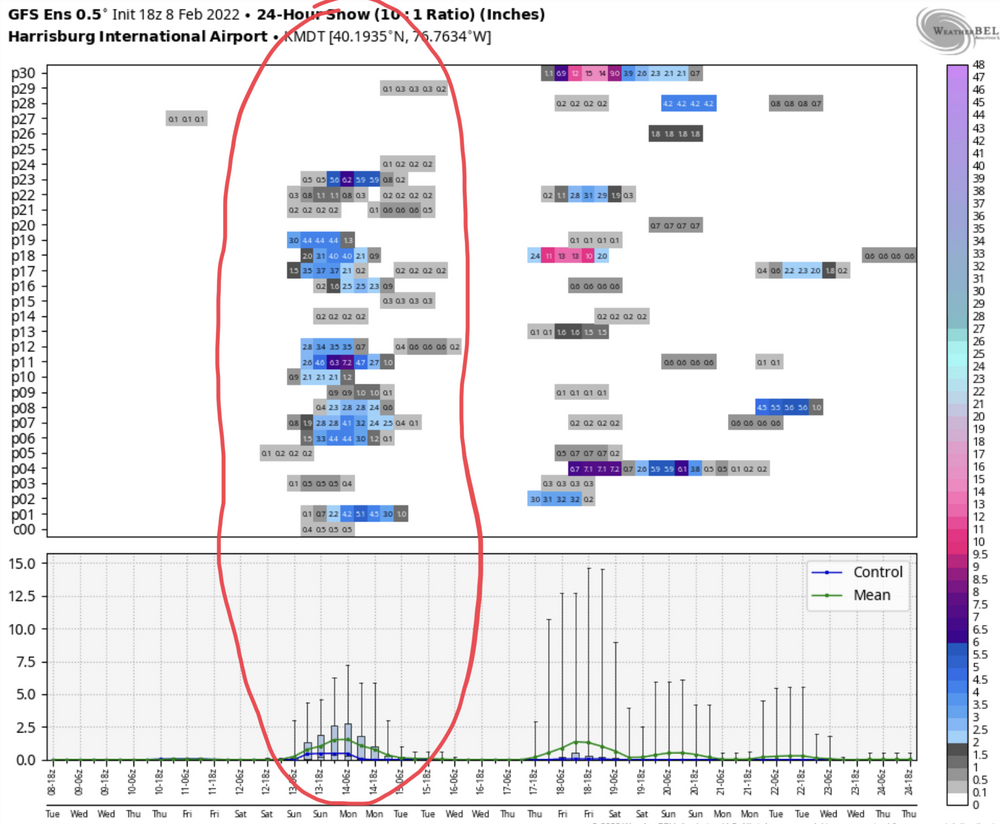
Here’s the member plots for MDT on 24 hr snow for both 18z Euro and GFS. I mean it’s still a good majority with not much but there’s definitely a signal there on both ensembles. The GEFS mean is showing roughly the evolution of what the last couple runs of the GFS op has been doing while there appears to be some Euro members (about 6-8 on rough count) that manage to yank this thing up the coast (even one or two cut and had the snow swath in western PA). 18z Euro EPS 18z GEFS Will say these ensemble meteograms looked nothing like this at around this range when we were trying to reel in the 1/28-29 storm. It took a while into the game before they finally started locking in on that one. So we’ll see if the better signal earlier can continue to improve. This is definitely worth watching the next couple days. Like I’ve said, we have the pattern alignment we need showing in this timeframe with a great western ridge. The key is how the features interact and their timing.

-
18z GFS pretty close to making a decent event with the potential Valentine’s Day-ish storm. Actually for the forum majority (LSV) it’s pretty good H-burg south. An improvement from 12z which had a lighter area of snow run the Mid-Atlantic but not getting into southern PA. Looks like it’s generated from the northern stream energy attempted to interact with the southern. Canadian today also had this (pretty light) while the Euro was a nothing burger. Definitely don’t think this threat is dead. The pattern alignment is there in that timeframe that if we can get good interaction/phase in time, this can be the type of event we’ve been looking for. This could also turn into another 1/29 (in terms of placement of best snow) if this comes back toward the storm scenario but not in time for us. Or… it could be nothing, but I think we’re already aware of that possibility. Either way this is still D5-6, which has felt like the limit this winter for the models starting to consistently start dialing in on something. Not that they ever are consistent at that range and beyond but models have seemed to have more trouble than usual in the mid range this winter. Likely due to the progressive pattern and many moving parts.
-
Some updated thoughts on the pattern. The quoted above was the large post I made back on Jan 28th for reference and review. First off that was at the time, in the 5-7 day range of what was for most in here our messy waste of QPF last week…but it did remind me that the event at that range had started on most modeling as a mostly rain event and a more pronounced warm-up. And while it did end up mostly rain for roughly SE half of PA, it did end up being more focused on the second wave and cold did get into western/northern PA to make for a half decent ice and snow event by the end. And western PA cleaned up some Friday with the remaining deform snow. Anyways, main focus on this post is the pattern going forward. There’s really no big changes to my overall thoughts, especially the portions of my quoted post I bolded. We really are going as the Pac goes in terms of the teleconnections with a +NAO/AO. This week, we have troughing over Alaska which cuts the Siberian connection and also turns the source region a bit more Pacific-ish even though there is still solid Pac ridging. Additionally. we have a pretty established +AO. Both of these things will act to evacuate true arctic air out of the CONUS. Still, our region will have seasonable chilly weather with a couple bouts of days with somewhat above average temps. Other issue with these points is the storm track. Clearly a northern branch dominated week with several clipper waves running it. However, the pattern alignment has the mean storm track taking the clipper lows fairly well north of PA. The result of this becomes the aforementioned bouts of above average surface temps with the milder temperature pattern and W/SW flow ahead of the clipper systems. This also usually presents downsloping issues east of the mountains in said W/SW flow with precip. Definitely a week we could have benefited from even just a little bit of help from the NAO/AO realm. Next chance of a bigger system appears to be roughly near Valentines Day, but there’s several issues to overcome there. Lot’s of different moving pieces is one issue, especially in the northern branch. That has been a theme for the last month or so since we’ve established the colder regime back in early January. Timing a phase with a less robust southern stream and associated issues with ejecting energy out of the SW US/Mexico is another. Still a chance to be be watched though as we do set up a western ridge/eastern trough for this timeframe, but currently it looks too progressive and not enough dig and interaction of features… with progression likely enhanced more given +NAO/AO. These are common Nina issues which by the way, we are still in presently (NDJ ONI average was -1.0ºC). Despite that, some of the US precip patterns have been very non Nina-like, especially in the Pac NW. A drier California is a pretty common thing but the Pac NW usually has above average precip in a Nina. They’ve been shut out the past month just like California has. I suspect that has had to do with the anomalous and very persistent northern Pac/western US ridging.. which has helped us stay in the game for systems (with not a lot of luck locally) and have provided us with the colder Eastern US version of the La Niña state temp-wise. The MJO has indeed tended more towards Phase 2/3 in the last week, and is forecast to remain in that realm at least in the interim.. esp on NCEP guidance. Those phases are “colder” phases, and the trend has staved off my worry of a renewed pulse running 4-5-6 during the business end of February. Something like that would have likely helped move along the type of wholesale pattern change in the Pacific that would have taken us out of commission in the East. The Pacific teleconnections still look workable, with the EPO/WPO trending back negative. Those two tellys are starting out neutral (WPO) to positive (EPO) this week as part of what had been a forecasted brief reversal from both being persistently negative. And you can see how we quickly lose the really cold air out of the pattern in the CONUS with that brief reversal. The cons are no help from the NAO/AO (pegged at a solid positive), and some trending toward a negative PNA toward week two (esp on Euro and CMC ensembles). So that’ll be interesting to see what that does if it comes to fruition. I suspect a negative PNA would instigate more storminess and precip across the CONUS but could put us on the wrong side of it if it’s too strong given +NAO/AO. This all boils down to me having the opinion that the second half of the month could be a good bit more active than what the first half is presently shaping up to be (sans the Feb 4th event).. but with that could come more swings in temp anomalies and less persistent cold. That’s nothing really groundbreaking for how the second half of February typically goes, but the chance should be there to cash in on something.